BlockBefore
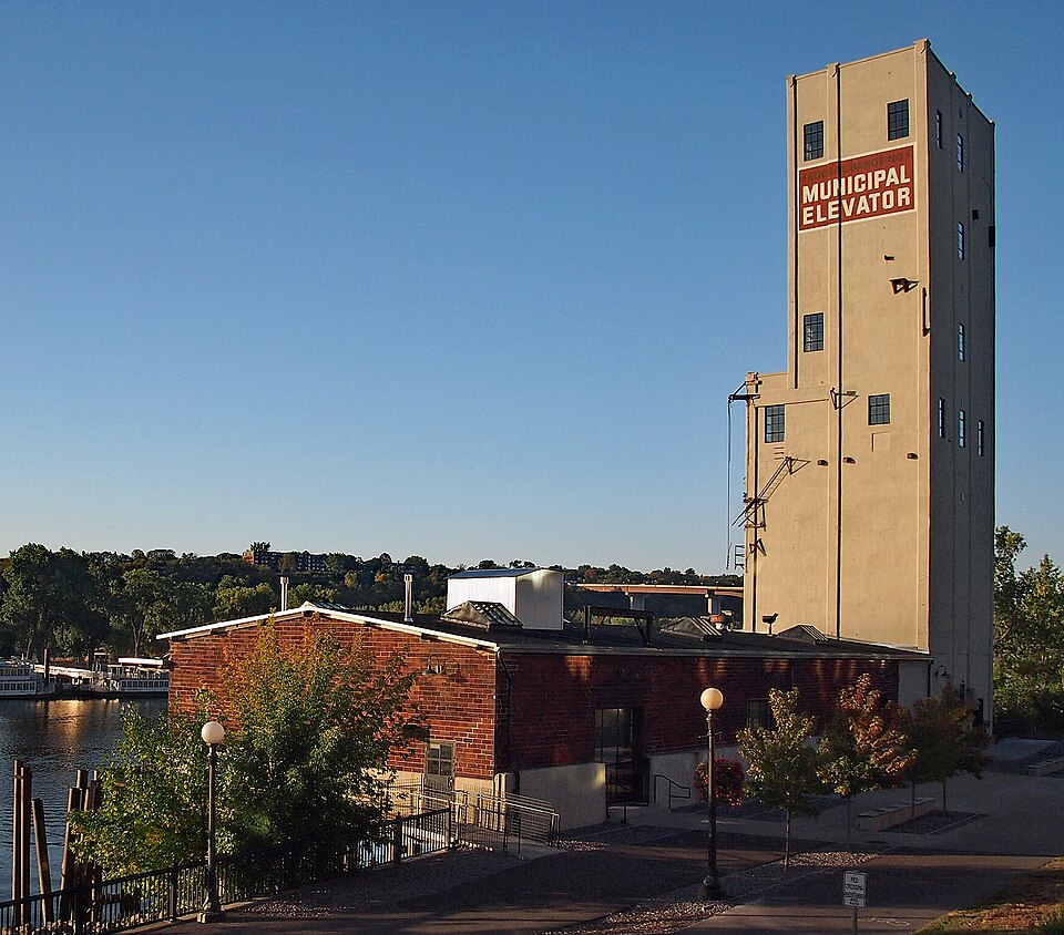
Photograph of Saint Paul Municipal Grain Terminal
Photograph by McGhiever, CC BY-SA 3.0. Via Wikimedia Commons.

St. Paul Municipal Grain Terminal

Listed on the National Register of Historic Places in 2004.

From the record

“The Saint Paul Municipal Grain Terminal is a six-story grain elevator also known as the head house and sack house, and sits on piers over the Mississippi River in Saint Paul, Minnesota, United States. It was built between 1927 and 1931 as part of the Equity Cooperative Exchange and is a remnant of Saint Paul's early history as a Mississippi River port city.”

Wikipedia article Saint Paul Municipal Grain Terminal, CC BY-SA 4.0.

One of 134 National Register listings published here for Ramsey County · listed in 2004 · category: Structure.

Sources: the Wikipedia article · the case file at the National Archives · the National Register database, National Park Service

The listing

  • What is counted as historic. The nomination lists 1 structure as contributing to the listing.
  • Address. 266 Old Shepard Rd., St. Paul, 55102
  • When was it listed? July 2004
  • Category. structure
  • Also known as. Grain Elevator Design in Minnesota MPS
  • City. St. Paul city
  • National Register reference number. 04000721 - the number the National Park Service assigned this property when it was listed, and the key its nomination file is catalogued under at the National Archives.

The ground it stands on

13,839 words

The chapter on St. Paul City in HIstory of Ramsey County and the CIty of St. Paul, published 1881 names St. Paul. This is what it says, exactly as the scans read.

May 18th, 1869. a formal call was extended to Rey. George A. Howard of Catskill, New York. which was declined by him after a visit to St. Paul. January 28th. 1869, the corner stone of the new chureh building was laid with appropriate ceremonies. and in December, the basement was ready for occupancy. the first public service held in it being the Christmas anniversary of the Sunday school. The next day, Sabbath, the first regular church service was held in the basement.

Passage source: HIstory of Ramsey County and the CIty of St. Paul, published 1881.

The necessity of choosing a pastor was apparent. and a call to the Rey. David R. Breed was | ordered. IIe soon after accepted, and in May, 1870, began his duties. In October, 1870, Mr. Breed was formally ordained to the ministry and installed as pastor of the church by the Presbytery of St. Paul.

Passage source: HIstory of Ramsey County and the CIty of St. Paul, published 1881.

Machine-read from a century-old scan, so expect the errors a machine makes: misspelled names, dropped words, stray characters.

Read the whole chapter on St. Paul City - 13,839 words on its settlement, mills, schools and churches.

Fires near this property

3 since 1996

Regional context, not property-specific evidence. The federal wildfire occurrence database lists 3 fires within 5 miles of St. Paul Municipal Grain Terminal between 1996 and 2020, burning about 2 acres in total. None started naturally. 1 was recorded as arson. Distance is straight-line from the map coordinates, so a fire counted here may appear on a neighbouring settlement's page as well.

Reported cause Fires
Missing data/not specified/undetermined1
Railroad operations and maintenance1
Arson/incendiarism1

The most recent of them, most recent first, with the day each was reported and the service that recorded it.

DateCause SizeReported by Name on the report
13 September 1996Missing data/not specified/undeterminedunder an acreMinnesota Department of Natural Resourcesnot named
1 April 2020Arson/incendiarism1.2 acresMinnesota Department of Natural ResourcesSAND DUNES
21 October 2000Railroad operations and maintenanceunder an acreMinnesota Department of Natural Resourcesnot named

Every fire recorded in Ramsey County

Mines and quarries near this property

3 within 5 miles

Regional context, not property-specific evidence. The federal mineral resources record lists 3 workings within 5 miles of St. Paul Municipal Grain Terminal: 1 occurrence, 1 producer, 1 past producer. 1 still produces. What was taken out: Clay, Kaolin. Distance is straight-line from the map coordinates, so a quarry counted here may appear on a neighbouring settlement's page as well.

Where SiteCommodity StatusRecorded
Twin City Brick Co. Clay PitKaolinProducerKaolinite
Dakota County Clay DepositClayOccurrence
Twin City Brick Co PitClayPast Producer

Every working recorded in Ramsey County

Map coverage status

No historic map-sheet match is published for this property yet. That does not mean no map exists. This record needs a coordinate-quality review before it can be joined to a sheet boundary. Browse the county's mapped places while that work is pending.

Listed places nearby

6 within 8 miles

Other National Register properties close enough to walk or drive between, ordered by distance from this one. Both positions come from the same geocoding pass that matched these properties to their map sheets.

Photograph PropertyDistance Listed
Minnesota Building0.1 miles2009
Alexander Ramsey House0.2 miles1969
Justus Ramsey Stone House0.2 miles1975
St. Paul Public/James J. Hill Reference Library0.3 miles1975
Irvine Park Historic District0.3 miles1973
Amhoist Tower0.3 miles2022

Sources for this property

National Archives recordThe nomination case file for reference 04000721 in Record Group 79.
Wikipedia articleCommunity-written account of this property, licensed CC BY-SA.
Ramsey CountyAll 134 listed properties in this county.

Provenance

  • Listing record. National Park Service National Register of Historic Places, listed-properties dataset, current to 2026-05-22.
  • Map join. Address geocoded through the United States Census geocoder, then tested against the published boundary of every sheet in the USGS Historical Topographic Map Collection.
  • How this page is made. Listing fields come from federal records; map-sheet coverage is a labelled coordinate-to-boundary calculation, not a source-field claim.
  • Wildfire. Short, Karen C. 2022. Spatial wildfire occurrence data for the United States, 1992-2020 [FPA_FOD_20221014]. 6th Edition. Fort Collins, CO: Forest Service Research Data Archive. https://doi.org/10.2737/RDS-2013-0009.6 Collected with United States Government funding and usable without additional permissions or fees.
  • Mines and quarries. USGS Mineral Resources Data System (MRDS) https://mrdata.usgs.gov/mrds/ A work of the United States government, no copyright under 17 U.S.C. 105.