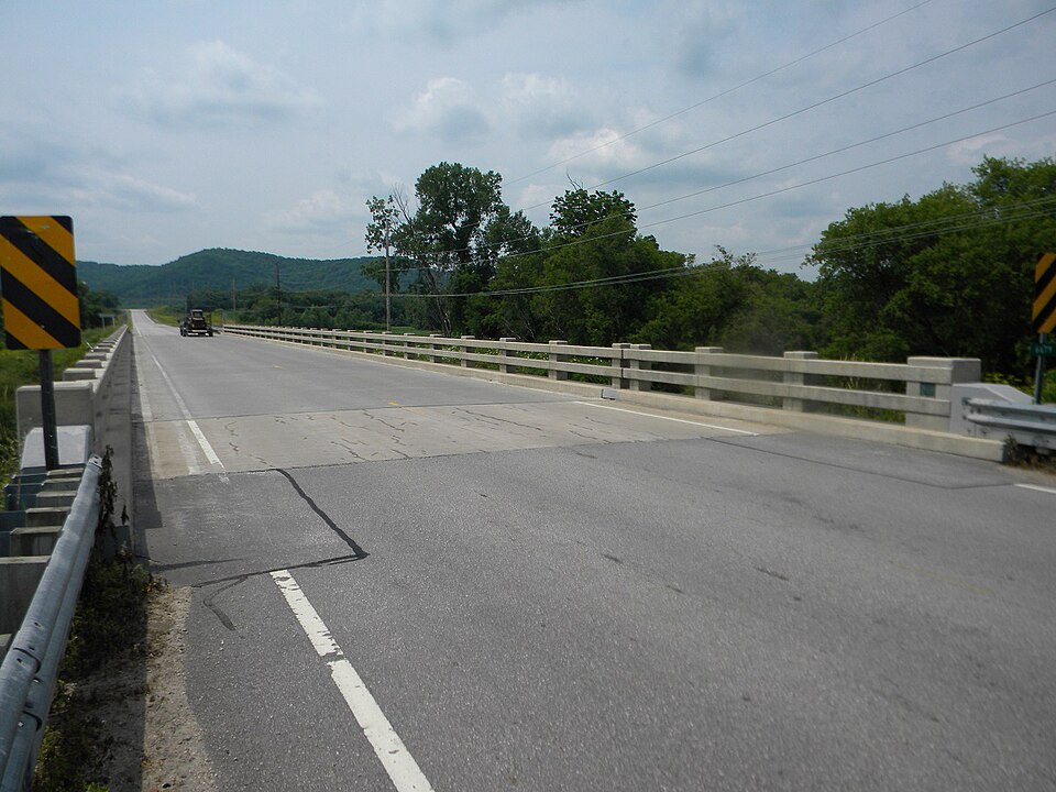
Listed on the National Register of Historic Places in 2011.
From the record
“Bridge No. 6679 is a 314-foot-long (96 m) bridge that carries State Highway 76 over the South Fork of the Root River near Houston, Minnesota. Built in 1949 at a cost of $118,000, it was a step in the evolution of I-beam bridges in Minnesota.”
Wikipedia article Bridge No. 6679, CC BY-SA 4.0.
One of 16 National Register listings published here for Houston County · listed in 2011 · category: Structure.
National Register reference number.11000468- the number the National Park Service assigned this property when it was listed, and the key its nomination file is catalogued under at the National Archives.
La Crescent is situated on portions of sections three^ ten and eleven, in township 104 north of range 4 west, in' Houston County, Slate of Minnesota. It lies on the west bank of the JJississippi River, opposite Nortli La Crosse, and a little noitli of opposite the city of La Crosse. From the steamboat landing at the city of La Crosse to the La Crescent landing is somewhat less than two miles.
Considering the difficulty which attends our pioneers generally in starting towns, and the length of time it takes to get the advantages of good town sites knoAvn to to the world, the town of Houston has not been backward in the race for population, wealth and enterprise which has distinguished the growth of many points in the county. Isor is at all an unfavorable point f«)ra rapid and permanent growth.
Regional context, not property-specific
evidence. The
federal wildfire occurrence database
lists 23 fires within 5 miles of Bridge No. 6679
between 1995 and 2018, burning about 169 acres in total. 1 started naturally. None was recorded as arson.
Distance is straight-line from the map coordinates, so a fire counted
here may appear on a neighbouring settlement's page as well.
Reported cause
Fires
Missing data/not specified/undetermined
9
Debris and open burning
9
Equipment and vehicle use
3
Recreation and ceremony
1
Natural
1
The most recent of
them, most recent first, with the day each was reported and the service
that recorded it.
Regional context, not property-specific
evidence. The federal mineral resources record lists
3 workings within 5 miles of Bridge No. 6679: 3 producers.
All of them still produce. What was taken out: Stone, Crushed/Broken. Distance is straight-line from the
map coordinates, so a quarry counted here may appear on a neighbouring
settlement's page as well.
Regional context, not property-specific
evidence. The National Weather Service names
Houston, the town this property stands in, in 30 storm reports between 1997 and 2025: 13 hail, 7 flood, 5 thunderstorm wind, 2 flash flood.
The reports record 1 death. Each account below is quoted exactly as the forecast office
filed it, from the NOAA Storm Events Database, and each date
opens the federal record of that event.
A 55-year old man was killed near Storer Creek when his mobile home was swept away by flash flooding. The man had been asked to evacuate twice before flood waters swept him and his home away. The normally tranquil trout stream was about 80 yards wide and 7 to 8 feet above nearby bridges.
Very heavy rain caused widespread flash flooding across a good portion of Houston County. Roads around the town of Houston became covered with water and impassable. Rapidly rising water along Riceford Creek caused a campground to be evacuated. A mudslide occurred just outside of Spring Grove. Numerous other roads around the county sustained damage, including County Highway 27 which had a complete section washed out. State Highway 16 east of Houston, State Highway 76 between Caledonia and Houston and County Highway 43 along with numerous other county roads were closed along with at least 20 township roads. In the western part of the county, one vehicle was swept off a road and the driver had to be rescued and at least three campers and a 73 foot mobile home were washed down Crystal Creek. In Hokah, the Root River rise high enough to top the levee requiring a local auto dealership to move about 60 cars to save them from the water. The flooding washed away a gravel road and two walking bridges at Camp Winnebago near Caledonia.
Law enforcement officials reported roads and bridges washed out or still under water. Houston was under mandatory evacuation orders until flood waters receded. Area highways were closed including Highway 26 from Money Creek to Rushford and Highway 9 from Highway 21 to the Winona/Houston County line.
The Root River at Houston reached a record crest of 18.75 feet on August 19. Flood stage is 15 feet. The town of Houston was completely cutoff by flood waters for awhile. Hundreds of acres of crops along the river were lost when they were inundated by flood waters.
Volunteer observers reported 0.1 of rainfall from bands of rain that moved through southeast Minnesota on October 6th. During the afternoon of October 6th, a tractor and pickup truck collided along Minnesota Highway 16 and Redding Road in Houston Township resulting in an injured passenger.
Runoff from rain and melting snow along with ice jams pushed the Root River out of its banks in Houston. The river crested over four feet above the flood stage at 19.28 feet on March 15th. This established a crest of record for this site.
An ice jam on the Root River caused flooding to occur in and around Houston. The ice jam formed after temperatures warmed into the 40s during the early part of February. The river crested almost a foot above the flood stage at 15.74 feet.
Locally heavy rains pushed the Root River at Houston out of its banks on September 23rd. The river gage failed during the flooding and the river is estimated to have returned to within its banks later the same day. The estimated crest was 15.4 feet, which is less than a half foot over the flood stage.
No historic map-sheet match is published
for this property yet. That does not mean no map exists. This record needs
a coordinate-quality review before it can be joined to a sheet boundary.
Browse the county's mapped places while that work is
pending.
Listed places nearby
3 within 8 miles
Other National Register properties close
enough to walk or drive between, ordered by distance from this one. Both
positions come from the same geocoding pass that matched these properties
to their map sheets.
Listing record. National Park Service National Register of Historic Places, listed-properties dataset, current to 2026-05-22.
Map join. Address geocoded through the United States Census geocoder, then tested against the published boundary of every sheet in the USGS Historical Topographic Map Collection.
How this page is made. Listing fields come from federal records; map-sheet coverage is a labelled coordinate-to-boundary calculation, not a source-field claim.
Wildfire. Short, Karen C. 2022. Spatial wildfire occurrence data for the United States, 1992-2020 [FPA_FOD_20221014]. 6th Edition. Fort Collins, CO: Forest Service Research Data Archive. https://doi.org/10.2737/RDS-2013-0009.6 Collected with United States Government funding and usable without additional permissions or fees.
Mines and quarries. USGS Mineral Resources Data System (MRDS) https://mrdata.usgs.gov/mrds/ A work of the United States government, no copyright under 17 U.S.C. 105.
Storms. NOAA National Centers for Environmental Information, Storm Events Database https://www.ncei.noaa.gov/stormevents/ A work of the United States government, no copyright under 17 U.S.C. 105. Narratives are quoted verbatim from the National Weather Service report and are not edited or summarised.
 Block