BlockBefore
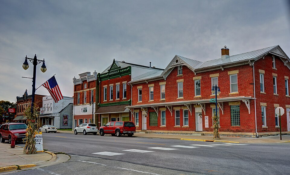
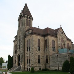
Photograph of Caledonia Commercial Historic District
Photograph by Kevin Schuchmann, CC BY-SA 3.0. Via Wikimedia Commons.

Caledonia Commercial Historic District

Listed on the National Register of Historic Places in 1994.

From the record

“There was an urgent demand for something better and more commodious. Belden laid the proposition before the executive committee of the Caledonia Commercial Club, an organization that has always promoted and used its influence for every cause that has been for the betterment of conditions and to whom one could appeal with confidence if his cause was one of public benefit and interest.”

History of Houston County, Minnesota (1919). Machine-read text.

One of 16 National Register listings published here for Houston County · listed in 1994 · category: District.

Sources: the county history on the Internet Archive · the case file at the National Archives · the National Register database, National Park Service
The listing

The ground it stands on

9,241 words

The chapter on Caledonia Township in History of Houston County, Minnesota, published 1919 names Caledonia. This is what it says, exactly as the scans read.

In the early days there were no places of amusement or community center. Until the churches were built, church services and other public meetings were held in the little old school house. Later, they were held in the old court house which was built over the county jail and which accommodated more people. Then a second court house was built which gave a larger seating capacity and it became the public hall. This building was replaced by the present creditable structure which was the largest public hall in Caledonia and was used for all large public gatherings until 1912 when the city hall was completed.

Passage source: History of Houston County, Minnesota, published 1919.

During the winter of 1911 there had been much talk among the more progressive men of the community of the need of some sort of social center, some place in which the people could get together under better conditions than those enjoyed. There were several organizations that needed a better place in which to carry on their work. The old building used as a city council room, voting room, fireman's hall, and public library, was too small for any of their purposes, poorly lighted, badly heated, dirty and with no accommodations fit for any of the purposes for which it was used and, in fact, a disgrace to a town of the size and importance of Caledonia.

Passage source: History of Houston County, Minnesota, published 1919.

Machine-read from a century-old scan, so expect the errors a machine makes: misspelled names, dropped words, stray characters.

Read the whole chapter on Caledonia Township - 9,241 words on its settlement, mills, schools and churches.

Fires near this property

38 since 1992

Regional context, not property-specific evidence. The federal wildfire occurrence database lists 38 fires within 5 miles of Caledonia Commercial Historic District between 1992 and 2017, burning about 191 acres in total. 1 started naturally. None was recorded as arson. Distance is straight-line from the map coordinates, so a fire counted here may appear on a neighbouring settlement's page as well.

Reported cause Fires
Debris and open burning20
Missing data/not specified/undetermined8
Equipment and vehicle use8
Natural1
Recreation and ceremony1

The most recent of them, most recent first, with the day each was reported and the service that recorded it.

DateCause SizeReported by Name on the report
17 September 2003Missing data/not specified/undeterminedunder an acreMinnesota Department of Natural Resourcesnot named
17 July 2001Naturalunder an acreMinnesota Department of Natural Resourcesnot named
4 June 1995Debris and open burningunder an acreMinnesota Department of Natural Resourcesnot named
3 June 2014Equipment and vehicle useunder an acreMinnesota Department of Natural Resourcesnot named
17 June 1995Debris and open burningunder an acreMinnesota Department of Natural Resourcesnot named
30 May 1996Debris and open burningunder an acreMinnesota Department of Natural Resourcesnot named
15 May 2002Debris and open burningunder an acreMinnesota Department of Natural Resourcesnot named
15 May 1995Debris and open burning2.0 acresMinnesota Department of Natural Resourcesnot named

Every fire recorded in Houston County

Mines and quarries near this property

3 within 5 miles

Regional context, not property-specific evidence. The federal mineral resources record lists 3 workings within 5 miles of Caledonia Commercial Historic District: 3 producers. All of them still produce. What was taken out: Stone, Crushed/Broken. Distance is straight-line from the map coordinates, so a quarry counted here may appear on a neighbouring settlement's page as well.

Where SiteCommodity StatusRecorded
Gengler Quarry & MillStone, Crushed/BrokenProducer
Holty-Badger Quarry - BadgerStone, Crushed/BrokenProducer
Holty-Badger Quarry- HoltyStone, Crushed/BrokenProducer

Every working recorded in Houston County

Storms near this property

32 since 1994

Regional context, not property-specific evidence. The National Weather Service names Caledonia, the town this property stands in, in 32 storm reports between 1994 and 2022: 16 thunderstorm wind, 9 hail, 2 flash flood, 2 heavy rain. No death or injury is recorded in these reports. Each account below is quoted exactly as the forecast office filed it, from the NOAA Storm Events Database, and each date opens the federal record of that event.

WhenEvent Place namedHarm What the report says
August 2018Heavy RainCaledonia$189,000Rainfall totaled 4.80 inches during this time frame.
June 2022Thunderstorm WindCaledonia$100,000A localized downburst blew down trees, power lines, a barn and some farm outbuildings just northwest of Caledonia.
September 2012Thunderstorm WindCaledonia$95,000An eighty foot tall tree fell on a garage and four vehicles near the intersection of First and Main Streets in Caledonia.
August 1997Tornado (F0)Caledonia$80,000no account filed
August 2018Flash FloodCaledonia$70,000Runoff from heavy rains caused street flooding to occur in Caledonia.
June 1998Thunderstorm WindCaledonia$40,000no account filed
June 1998Thunderstorm WindCaledonia$35,000no account filed
March 2017Thunderstorm WindCaledonia$34,000Barns were damaged in the Caledonia area from strong storm winds.
June 1999HailCaledonia$15,000no account filed
August 1997Thunderstorm WindCaledonia$15,000no account filed
August 2000HailCaledonia$12,000no account filed
May 2007Thunderstorm WindCaledonia$10,000Roof damaged at elementary school.
June 1998HailCaledonia$10,000no account filed
May 2012Thunderstorm WindCaledonia$5,000Trees were blown down onto parts of State Highway 76 between Houston and Caledonia.
July 2012LightningCaledonia$5,000Lightning struck the Houston County Courthouse and knocked out phone services, destroyed a control module for one of the ventilation units and a copy machine.
August 2000HailCaledonia$5,000no account filed
June 1997Thunderstorm WindCaledonia$5,000no account filed
June 1998Thunderstorm WindCaledonia$4,000no account filed
September 2005Thunderstorm WindCaledonia$1,500no account filed
May 2007Thunderstorm WindCaledonia$1,000Siding ripped off and overhang damaged on mobile home.
August 2007Flash FloodCaledonia$1,000Law enforcement officials reported water over the roadway near Green Acres and across other sections of the county.
June 2000Thunderstorm WindCaledonia$250no account filed
August 2017Funnel CloudCaledonia-A funnel cloud was sighted northeast of Caledonia.
September 2016Heavy RainCaledonia-The COOP observer in Caledonia measured 4.41 inches of rain.
July 2013HailCaledonia-Up to half dollar sized hail fell in Caledonia.
July 1994Thunderstorm WindCaledonia-Several trees and power lines were blown down by strong thunderstorm winds.
May 2011HailCaledonia-no account filed
April 2010HailCaledonia-no account filed
April 2002HailCaledonia-no account filed
May 1998Thunderstorm WindCaledonia-no account filed
June 1997HailCaledonia-no account filed
June 1996Thunderstorm WindCaledonia-no account filed

Every storm recorded in Houston County

Map coverage status

No historic map-sheet match is published for this property yet. That does not mean no map exists. This record needs a coordinate-quality review before it can be joined to a sheet boundary. Browse the county's mapped places while that work is pending.

Listed places nearby

6 within 8 miles

Other National Register properties close enough to walk or drive between, ordered by distance from this one. Both positions come from the same geocoding pass that matched these properties to their map sheets.

Photograph PropertyDistance Listed
Spafford Williams Hotel0.1 miles1982
David R. and Ellsworth A. Sprague Houses0.2 miles1982
Houston County Courthouse and Jail0.3 miles1983
Schech Mill4.7 miles1978
Portland Prairie Methodist Episcopal Church7.6 miles1982
Bridge No. 66797.9 miles2011

Sources for this property

National Archives recordThe nomination case file for reference 94000830 in Record Group 79.
Houston CountyAll 16 listed properties in this county.

Provenance

  • Listing record. National Park Service National Register of Historic Places, listed-properties dataset, current to 2026-05-22.
  • Map join. Address geocoded through the United States Census geocoder, then tested against the published boundary of every sheet in the USGS Historical Topographic Map Collection.
  • How this page is made. Listing fields come from federal records; map-sheet coverage is a labelled coordinate-to-boundary calculation, not a source-field claim.
  • Wildfire. Short, Karen C. 2022. Spatial wildfire occurrence data for the United States, 1992-2020 [FPA_FOD_20221014]. 6th Edition. Fort Collins, CO: Forest Service Research Data Archive. https://doi.org/10.2737/RDS-2013-0009.6 Collected with United States Government funding and usable without additional permissions or fees.
  • Mines and quarries. USGS Mineral Resources Data System (MRDS) https://mrdata.usgs.gov/mrds/ A work of the United States government, no copyright under 17 U.S.C. 105.
  • Storms. NOAA National Centers for Environmental Information, Storm Events Database https://www.ncei.noaa.gov/stormevents/ A work of the United States government, no copyright under 17 U.S.C. 105. Narratives are quoted verbatim from the National Weather Service report and are not edited or summarised.