BlockBefore
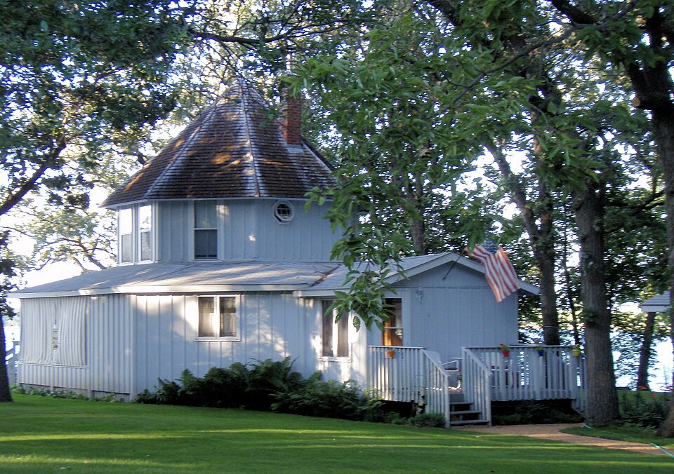
Photograph of Brightwood Beach Cottage
Photograph by Elkman, CC BY-SA 3.0. Via Wikimedia Commons.

Brightwood Beach Cottage

Built in 1889. Listed on the National Register of Historic Places in 1978.

From the record

“Brightwood Beach Cottage is an historic octagonal building on the southern shore of Lake Ripley in Litchfield, Minnesota, United States, that once was a part of the Brightwood Beach Resort of the late nineteenth century. The resort opened in 1889, and it offered cultural amenities such as concerts, classes in fine arts, and other live entertainment.”

Wikipedia article Brightwood Beach Cottage, CC BY-SA 4.0.

One of 10 National Register listings published here for Meeker County · listed in 1978 · category: Building · built in 1889.

Sources: the Wikipedia article · the case file at the National Archives · the National Register database, National Park Service

The listing

  • What is counted as historic. The nomination lists 1 building as contributing to the listing.
  • Address. S. Ripley Dr., Litchfield, 55355
  • When was it listed? May 1978
  • Category. building
  • Township. Litchfield township
  • When was it built? 1889
  • National Register reference number. 78001551 - the number the National Park Service assigned this property when it was listed, and the key its nomination file is catalogued under at the National Archives.

Fires near this property

4 since 2001

Regional context, not property-specific evidence. The federal wildfire occurrence database lists 4 fires within 5 miles of Brightwood Beach Cottage between 2001 and 2015, burning about 349 acres in total. None started naturally. None was recorded as arson. Distance is straight-line from the map coordinates, so a fire counted here may appear on a neighbouring settlement's page as well.

Reported cause Fires
Debris and open burning3
Missing data/not specified/undetermined1

The most recent of them, most recent first, with the day each was reported and the service that recorded it.

DateCause SizeReported by Name on the report
2 May 2015Debris and open burning217 acresLitchfield Wetland Management DistrictSTONE LAKE WF
26 April 2001Debris and open burning105 acresMinnesota Department of Natural Resourcesnot named
29 November 2012Debris and open burning26 acresMinnesota Department of Natural Resourcesnot named
11 November 2013Missing data/not specified/undetermined1.0 acresLitchfield Wetland Management DistrictLITCHFIELD WF

Every fire recorded in Meeker County

Storms near this property

51 since 1993

Regional context, not property-specific evidence. The National Weather Service names Litchfield, the town this property stands in, in 51 storm reports between 1993 and 2025: 27 hail, 19 thunderstorm wind, 2 tornado, 2 funnel cloud. The reports record 3 injuries. Each account below is quoted exactly as the forecast office filed it, from the NOAA Storm Events Database, and each date opens the federal record of that event.

WhenEvent Place namedHarm What the report says
September 2005Thunderstorm WindLitchfield3 hurtFire and rescue officials reported that high winds overturned a trailer camper at Lake Ripley Campground. Three people were pined inside and were transported to the hospital after rescue. A woman and a man in the trailer suffered minor injuries and the third victim, a retired police officer, suffered cracked ribs and numbness in his legs. Two other unoccupied campers were overturned nearby and others were damaged. Trees were also downed around town. A wind gust of 55 MPH was recorded at the Litchfield airport at 3:55 PM CDT.
July 2025Thunderstorm WindLitchfield-Multiple trees down in Litchfield.
July 2023Thunderstorm WindLitchfield-Public works responded to 1 large branch across the road.
May 2022Thunderstorm WindLitchfield-The county courthouse sustained roof damage. Numerous trees were uprooted around Litchfield. Time estimated based on radar.
June 2017Thunderstorm WindLitchfield-Wind gust reported by RAWS station LFSM5, Litchfield 3S, operated by the U.S. Fish and Wildlife Service.
June 2016Heavy RainLitchfield-A rainfall report of 2.76 inches occurred south of Litchfield in less than 6 hours.
July 2016Tornado (EF2)Litchfield-The tornado near Litchfield was rated an EF-2 with peak winds of 115 mph. It had a maximum width of 100 yards and traveled approximately 3.2 miles. The tornado caused a lot of tree damage, though three single family homes received significant roof damage, and a double wide manufactured home, and garage were flipped and rolled. Another garage and shed were destroyed near Highway 12 on the north side of town.
August 2013Thunderstorm WindLitchfield-Several large tree branches were blown down in Litchfield.
August 2011Thunderstorm WindLitchfield-A measured wind gust at the Litchfield RAWS site.
July 2011Thunderstorm WindLitchfield-A large tree fell near Southside Park in Litchfield.
August 2011Thunderstorm WindLitchfield-Several large tree branches were blown down on the east side of Litchfield, Minnesota.
July 2008Funnel CloudLitchfield-The funnel cloud dropped briefly out of the parent thunderstorm, then quickly went back up.
September 2007Thunderstorm WindLitchfield-Numerous trees were felled, including some 22 inches in diameter. One tree fell on a mobile home in the north side of Litchfield.
June 2006HailLitchfield-Hail covered the ground.
May 2006HailLitchfield-Hail covered Highway 22.
June 2005Funnel CloudLitchfield-The Sheriff's department stated that several motorists reported seeing a funnel cloud.
June 2005Thunderstorm WindLitchfield-Trees were downed near Round Lake.
June 2005Thunderstorm WindLitchfield-A pontoon boat was flipped and a dock was destroyed along the Lake Ripley shoreline.
September 2005HailLitchfield-Quarter to golf ball sized hail was reported by a trained spotter. The county sheriff's office reported that several squad cars sustained hail damage. The windshield on one patrol car was broken by the hail.
June 2004Thunderstorm WindLitchfield-A tree was downed.
May 2004Thunderstorm WindLitchfield-Two turkey barns were slightly damaged along Route 23 near Long Lake.
June 2002HailLitchfield-Ground white.
June 2001Tornado (F1)Litchfield-Damage survey indicated brief tornado on the west side of Lake Ripley, downing trees and ripping apart sheds and outbuildings. Tornado was accompanied by a large swath of damaging wind.
June 2001HailLitchfield-Wind blown hail dented houses, vehicles, and hundreds of structures.
July 1999Thunderstorm WindLitchfield-Estimated winds. Several docks and boats flipped on Lake Minnie Belle.
June 1999Thunderstorm WindLitchfield-Large branches blown down. Estimated windspeed.
July 2025HailLitchfield-no account filed
July 2023HailLitchfield-no account filed
August 2013HailLitchfield-no account filed
May 2012HailLitchfield-no account filed
August 2011HailLitchfield-no account filed
September 2007HailLitchfield-no account filed
April 2007HailLitchfield-no account filed
September 2005HailLitchfield-no account filed
May 2004HailLitchfield-no account filed
June 2004HailLitchfield-no account filed
June 2002HailLitchfield-no account filed
June 2001HailLitchfield-no account filed
May 2000HailLitchfield-no account filed
May 1998HailLitchfield-no account filed
July 1997Thunderstorm WindLitchfield-no account filed
July 1997HailLitchfield-no account filed
June 1996HailLitchfield-no account filed
August 1996Thunderstorm WindLitchfield-no account filed
June 1994HailLitchfield-no account filed
August 1993Thunderstorm WindLitchfield-no account filed

Every storm recorded in Meeker County

Map coverage status

No historic map-sheet match is published for this property yet. That does not mean no map exists. This record needs a coordinate-quality review before it can be joined to a sheet boundary. Browse the county's mapped places while that work is pending.

Listed places nearby

6 within 8 miles

Other National Register properties close enough to walk or drive between, ordered by distance from this one. Both positions come from the same geocoding pass that matched these properties to their map sheets.

Photograph PropertyDistance Listed
Litchfield Opera House2.1 miles1984
Litchfield Commercial Historic District2.1 miles1996
Grand Army of the Republic Hall2.2 miles1975
Trinity Episcopal Church2.3 miles1975
Ness Lutheran Church and Cemetery3.2 miles2025
Henry Ames House4.0 miles1984

Sources for this property

National Archives recordThe nomination case file for reference 78001551 in Record Group 79.
Wikipedia articleCommunity-written account of this property, licensed CC BY-SA.
Meeker CountyAll 10 listed properties in this county.

Provenance

  • Listing record. National Park Service National Register of Historic Places, listed-properties dataset, current to 2026-05-22.
  • Map join. Address geocoded through the United States Census geocoder, then tested against the published boundary of every sheet in the USGS Historical Topographic Map Collection.
  • How this page is made. Listing fields come from federal records; map-sheet coverage is a labelled coordinate-to-boundary calculation, not a source-field claim.
  • Wildfire. Short, Karen C. 2022. Spatial wildfire occurrence data for the United States, 1992-2020 [FPA_FOD_20221014]. 6th Edition. Fort Collins, CO: Forest Service Research Data Archive. https://doi.org/10.2737/RDS-2013-0009.6 Collected with United States Government funding and usable without additional permissions or fees.
  • Storms. NOAA National Centers for Environmental Information, Storm Events Database https://www.ncei.noaa.gov/stormevents/ A work of the United States government, no copyright under 17 U.S.C. 105. Narratives are quoted verbatim from the National Weather Service report and are not edited or summarised.