 Block
From the record
One of 42 National Register listings published here for Washington County · listed in 1978 · category: Structure.
Sources: the case file at the National Archives · the National Register database, National Park Service
Listed on the National Register of Historic Places in 1978.
One of 42 National Register listings published here for Washington County · listed in 1978 · category: Structure.
Sources: the case file at the National Archives · the National Register database, National Park Service
Regional context, not property-specific evidence. The federal wildfire occurrence database lists 2 fires within 5 miles of Grey Cloud Lime Kiln between 2012 and 2018, burning about 85 acres in total. None started naturally. None was recorded as arson. Distance is straight-line from the map coordinates, so a fire counted here may appear on a neighbouring settlement's page as well.
| Reported cause | Fires |
|---|---|
| Equipment and vehicle use | 1 |
| Missing data/not specified/undetermined | 1 |
The most recent of them, most recent first, with the day each was reported and the service that recorded it.
| Date | Cause | Size | Reported by | Name on the report |
|---|---|---|---|---|
| 25 April 2018 | Missing data/not specified/undetermined | 75 acres | Minnesota Valley National Wildlife Refuge | GREY CLOUD |
| 17 March 2012 | Equipment and vehicle use | 10 acres | Minnesota Valley National Wildlife Refuge | INNOVATION |
Regional context, not property-specific evidence. The federal mineral resources record lists 9 workings within 5 miles of Grey Cloud Lime Kiln: 6 producers, 2 plants, 1 unknown. 8 still produce. What was taken out: Sand and Gravel, Construction, Sulfur, Stone, Crushed/Broken. Distance is straight-line from the map coordinates, so a quarry counted here may appear on a neighbouring settlement's page as well.
| Where | Site | Commodity | Status | Recorded |
|---|---|---|---|---|
| Shiely Larson Quarry & Plant | Stone, Crushed/Broken | Producer | ||
| (Facility) Northwestern Refinery | Sulfur | Plant | ||
| (Facility) Pine Bend Refinery | Sulfur | Plant | ||
| Cottage Grove Pit and Mill | Sand and Gravel, Construction | Producer | ||
| Nelson Pit and Mill | Sand and Gravel, Construction | Producer | ||
| Noltiemeyer Pit and Mill | Sand and Gravel, Construction | Producer | ||
| Noltiemeyer Pit and Mill | Sand and Gravel, Construction | Producer | ||
| Riggs Pit and Mill | Sand and Gravel, Construction | Producer | ||
| Sand & Gravel Pit | Sand and Gravel, Construction | Unknown |
Regional context, not property-specific evidence. The National Weather Service names Cottage Grove, the town this property stands in, in 33 storm reports between 1996 and 2024: 15 hail, 13 thunderstorm wind, 2 lightning, 1 funnel cloud. The reports record 2 injuries. Each account below is quoted exactly as the forecast office filed it, from the NOAA Storm Events Database, and each date opens the federal record of that event.
| When | Event | Place named | Harm | What the report says |
|---|---|---|---|---|
| October 2005 | Lightning | Cottage Grove | 2 hurt | A lightning strike hit a home in the 7900 Block of 71st Street. The bolt caused an immediate explosion, and injured two 50 year olds who owned the home. The individuals were transported to Regions Hospital, where they were listed in fair and stable condition on the 5th. The fire destroyed the residence and caused some damage to neighboring residences. |
| May 1996 | Thunderstorm Wind | Cottage Grove | $800,000 | no account filed |
| July 2020 | Tornado (EF1) | Cottage Grove | $100,000 | A NWS Storm Survey indicated that an EF1 tornado occurred in far southern Washington County, in a rural area, north of Hastings, Minnesota. ||The tornado spun up 5 miles north of Hastings, Minnesota, and tracked eastward for 3.2 miles until it moved across the St. Croix River, and into Wisconsin. Extensive tree damage occurred along its path, with the heaviest damage on top of the bluff as it moved across the St. Croix River into Wisconsin. A few farm outbuildings were also damaged. The tornado had a maximum speed of 100 mph, with a maximum width of 400 yards. |
| June 2012 | Thunderstorm Wind | Cottage Grove | $25,000 | Scattered trees were downed across the southern part of Washington County from south of Cottage Grove, northeast to near Afton. In addition, there were sporadic reports of power outages due to power lines downed. |
| June 2010 | Thunderstorm Wind | Cottage Grove | $20,000 | Several large trees and power lines were blown down in Cottage Grove, Minnesota. |
| September 2024 | Hail | Cottage Grove | - | Report from Mping. |
| August 2021 | Hail | Cottage Grove | - | A public report of quarter size hail relayed from a local TV Meteorologist. |
| July 2016 | Thunderstorm Wind | Cottage Grove | - | Multiple trees were blown down near Cottage Grove. |
| October 2016 | Hail | Cottage Grove | - | A swath of 0.75 inch hail occurred in the southern part of Washington County from Cottage Grove, east to the Wisconsin border. |
| June 2014 | Heavy Rain | Cottage Grove | - | A 24 hour rainfall total of 4.00 inches was reported. |
| May 2013 | Thunderstorm Wind | Cottage Grove | - | A private weather station reported a wind gust of 58 mph near Cottage Grove, Minnesota. |
| August 2011 | Thunderstorm Wind | Cottage Grove | - | Several large tree branches were blown down. |
| May 2006 | Hail | Cottage Grove | - | Hail occurred at Fire Station Number 2, located near the center of town. |
| July 2005 | Thunderstorm Wind | Cottage Grove | - | Limbs up to 4 inches in diameter fell onto power lines. |
| July 2005 | Lightning | Cottage Grove | - | Lightning struck a home near the intersection of Highway 61 and Jamaica Avenue. The resulting fire caused minor damage to the structure. |
| April 2004 | Thunderstorm Wind | Cottage Grove | - | Trees and power lines were downed. A silo was damaged. |
| June 2001 | Thunderstorm Wind | Cottage Grove | - | Few trees and power lines down. |
| June 2001 | Thunderstorm Wind | Cottage Grove | - | Few trees and power lines down. |
| June 1998 | Thunderstorm Wind | Cottage Grove | - | Large branches down. Estimated windspeed. |
| May 1998 | Thunderstorm Wind | Cottage Grove | - | 1000 trees lost. 29 homes uninhabitable. 548 homes sustained damage. Estimated windspeed. |
| August 2023 | Hail | Cottage Grove | - | no account filed |
| September 2016 | Hail | Cottage Grove | - | no account filed |
| September 2016 | Hail | Cottage Grove | - | no account filed |
| June 2015 | Hail | Cottage Grove | - | no account filed |
| April 2012 | Hail | Cottage Grove | - | no account filed |
| July 2010 | Funnel Cloud | Cottage Grove | - | no account filed |
| June 2007 | Hail | Cottage Grove | - | no account filed |
| May 2004 | Hail | Cottage Grove | - | no account filed |
| April 2002 | Hail | Cottage Grove | - | no account filed |
| June 1999 | Hail | Cottage Grove | - | no account filed |
| June 1999 | Hail | Cottage Grove | - | no account filed |
| June 1997 | Hail | Cottage Grove | - | no account filed |
| June 1996 | Thunderstorm Wind | Cottage Grove | - | no account filed |
No historic map-sheet match is published for this property yet. That does not mean no map exists. This record needs a coordinate-quality review before it can be joined to a sheet boundary. Browse the county's mapped places while that work is pending.
Other National Register properties close enough to walk or drive between, ordered by distance from this one. Both positions come from the same geocoding pass that matched these properties to their map sheets.
| Photograph | Property | Distance | Listed |
|---|---|---|---|
 | Cordenio Severance House | 5.0 miles | 1976 |
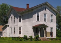 | John P. Furber House | 5.6 miles | 1982 |
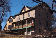 | Charles Spangenberg Farmstead | 6.2 miles | 1978 |
| National Archives record | The nomination case file for reference 78001568 in Record Group 79. |
| Washington County | All 42 listed properties in this county. |