BlockBefore
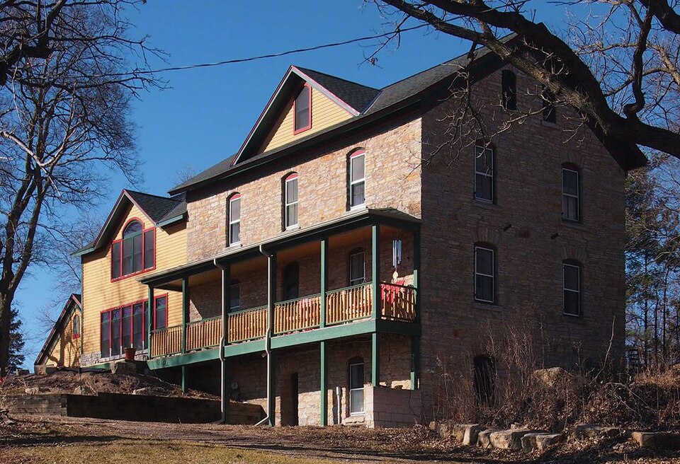
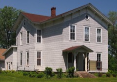
Photograph of Charles Spangenberg Farmstead
Photograph by McGhiever, CC BY-SA 4.0. Via Wikimedia Commons.

Charles Spangenberg Farmstead

Listed on the National Register of Historic Places in 1978.

From the record

“The Charles Spangenberg Farmstead is a historic farm in Woodbury, Minnesota, United States, established in 1869. The three oldest buildings, including an 1871 farmhouse, were listed together on the National Register of Historic Places in 1978 for having local significance in the theme of agriculture.”

Wikipedia article Charles Spangenberg Farmstead, CC BY-SA 4.0.

One of 42 National Register listings published here for Washington County · listed in 1978 · category: Building.

Sources: the Wikipedia article · the case file at the National Archives · the National Register database, National Park Service

The listing

  • What is counted as historic. The nomination lists 3 buildingss as contributing to the listing.
  • Listed as. Spangenberg, Charles, Farmstead - the National Register files a house under its owner's surname.
  • Address. SE of Woodbury at 9431 Dale Rd., Woodbury, 55129
  • When was it listed? December 1978
  • Category. building
  • Also known as. Washington County MRA (AD); Washington County MRA
  • City. Woodbury city
  • National Register reference number. 78001570 - the number the National Park Service assigned this property when it was listed, and the key its nomination file is catalogued under at the National Archives.

The ground it stands on

118 words

This property stands in Woodbury City. History of Washington County and the St. Croix Valley Including the Explorers and Pioneers of Minnesota, published 1881 gives that township a chapter of its own.

The chapter covers the township.

Machine-read from a century-old scan, so expect the errors a machine makes: misspelled names, dropped words, stray characters.

Read the whole chapter on Woodbury City - 118 words on its settlement, mills, schools and churches.

Fires near this property

1 since 2017

Regional context, not property-specific evidence. The federal wildfire occurrence database lists 1 fire within 5 miles of Charles Spangenberg Farmstead in 2017, burning about 6 acres in total. None started naturally. None was recorded as arson. Distance is straight-line from the map coordinates, so a fire counted here may appear on a neighbouring settlement's page as well.

Reported cause Fires
Debris and open burning1

The most recent of them, most recent first, with the day each was reported and the service that recorded it.

DateCause SizeReported by Name on the report
1 April 2017Debris and open burning6.0 acresMinnesota Department of Natural Resourcesnot named

Every fire recorded in Washington County

Mines and quarries near this property

7 within 5 miles

Regional context, not property-specific evidence. The federal mineral resources record lists 7 workings within 5 miles of Charles Spangenberg Farmstead: 5 producers, 1 plant, 1 past producer. 6 still produce. What was taken out: Sand and Gravel, Construction, Sulfur, Silica. Distance is straight-line from the map coordinates, so a quarry counted here may appear on a neighbouring settlement's page as well.

Where SiteCommodity StatusRecorded
(Facility) Northwestern RefinerySulfurPlant
Twincities Silica Pit & MillSilicaPast Producer
Afton Road PitSand and Gravel, ConstructionProducer
Cottage Grove Pit and MillSand and Gravel, ConstructionProducer
Noltiemeyer Pit and MillSand and Gravel, ConstructionProducer
Riggs Pit and MillSand and Gravel, ConstructionProducer

Every working recorded in Washington County

Storms near this property

50 since 1996

Regional context, not property-specific evidence. The National Weather Service names Woodbury, the town this property stands in, in 50 storm reports between 1996 and 2026: 30 hail, 16 thunderstorm wind, 2 tornado, 1 flash flood. No death or injury is recorded in these reports. Each account below is quoted exactly as the forecast office filed it, from the NOAA Storm Events Database, and each date opens the federal record of that event.

WhenEvent Place namedHarm What the report says
May 1998Thunderstorm WindWoodbury$14,000,000Roofs off houses. Estimated windspeed.
May 1996HailWoodbury$1,700,000no account filed
September 2007Tornado (EF0)Woodbury$500,000A National Weather Service storm survey confirmed an EF-0 tornado touched down in the southwestern portion of Woodbury, along Bailey Road.|It dissipated when it reached Woodlane Drive. The tornado caused damage to multiple townhouses, trees, and road signs.
May 2017LightningWoodbury$450,000A home in Woodbury was struck by lightning and caused enough damage to make the home unlivable. No injuries were reported as the homeowner was not at home.
May 2012HailWoodbury$100,000The public reported golf ball hail near the intersection of Bailey Road, and Woodlane in Woodbury, Minnesota. In addition, roof and car damage was reported around Woodbury due to the large hail stones.
August 2009Thunderstorm WindWoodbury$50,000A NWS Skywarn Instructor, who is a broadcast meteorologist, surveyed an area of that was associated with straight-line wind damage that occurred in a new subdivision in Stonemill Farms in Woodbury, Minnesota. The damage was mainly to trees blown down and some siding blown off homes around Aster Lane, Windmill Curve, Walden Drive and Sawmill Curve.
September 2025HailWoodbury-Report received via mPING.
June 2025Thunderstorm WindWoodbury-Measured just southeast of Radio Dr and Lake Rd.
September 2025HailWoodbury-Report received via mPING.
September 2025HailWoodbury-Report submitted via X.
July 2024Thunderstorm WindWoodbury-A storm chaser measured the wind gust on a personal weather station.
August 2023Thunderstorm WindWoodbury-A picture was shared on social media showing large trees uprooted and a home fence that was knocked over.
August 2021HailWoodbury-Most of the hail was pea to dime size over the Woodbury area.
July 2020Tornado (EF0)Woodbury-A tornado damaged about one dozen trees, soffit was ripped off a house, a semi was tipped over, and about six greenhouse hoops were damaged.
July 2019Thunderstorm WindWoodbury-Wind gust measured by a home weather station. In addition, several large tree branches were blown down.
August 2018Thunderstorm WindWoodbury-A large tree was snapped off in Woodbury.
October 2018Thunderstorm WindWoodbury-Several trees were blown down halfway between Woodbury, and Lakeland.
July 2016Thunderstorm WindWoodbury-Several large tree branches and a few small trees were blown down across the city of Woodbury.
May 2012HailWoodbury-Several areas between Newport and Woodbury received up to golf ball size hail.
July 2009HailWoodbury-Local amateur radio operators reported nickel to quarter size hail near Woodbury.
August 2007Thunderstorm WindWoodbury-Three inch diameter branches felled just north of I-94.
September 2007HailWoodbury-Hail occurred at I-494 and Tamarack Road.
June 2005Thunderstorm WindWoodbury-A citizen on Duckwood Trail recorded a wind gust of 59 MPH. A tree on the property was downed onto a deck. More than 50 trees were downed across the city, mainly south of Valley Creek Road and west of Woodbury Drive. The Colby Lake development was hardest hit. One home lost a corner of its roof and yard objects were thrown around.
July 2003Thunderstorm WindWoodbury-Numerous trees felled.
June 1997Thunderstorm WindWoodbury-4 inch diameter tree limbs down. Estimated windspeed.
June 1997HailWoodbury-Three inches of rain and street flooding reported in area.
April 2026HailWoodbury-no account filed
August 2025HailWoodbury-no account filed
May 2022HailWoodbury-no account filed
September 2022HailWoodbury-no account filed
May 2012HailWoodbury-no account filed
April 2006HailWoodbury-no account filed
June 2005HailWoodbury-no account filed
May 2004HailWoodbury-no account filed
May 2001HailWoodbury-no account filed
June 1998Thunderstorm WindWoodbury-no account filed
June 1998HailWoodbury-no account filed
July 1997Thunderstorm WindWoodbury-no account filed
July 1997Flash FloodWoodbury-no account filed
May 1996Thunderstorm WindWoodbury-no account filed
May 1996HailWoodbury-no account filed

Every storm recorded in Washington County

Map coverage status

No historic map-sheet match is published for this property yet. That does not mean no map exists. This record needs a coordinate-quality review before it can be joined to a sheet boundary. Browse the county's mapped places while that work is pending.

Listed places nearby

6 within 8 miles

Other National Register properties close enough to walk or drive between, ordered by distance from this one. Both positions come from the same geocoding pass that matched these properties to their map sheets.

Photograph PropertyDistance Listed
Cordenio Severance House1.9 miles1976
John P. Furber House2.7 miles1982
Grey Cloud Lime Kiln6.2 miles1978
Newington Gilbert House6.4 miles1982
Erastus Bolles House6.4 miles1982
Cushing Hotel6.7 miles1985

Sources for this property

National Archives recordThe nomination case file for reference 78001570 in Record Group 79.
Wikipedia articleCommunity-written account of this property, licensed CC BY-SA.
Washington CountyAll 42 listed properties in this county.

Provenance

  • Listing record. National Park Service National Register of Historic Places, listed-properties dataset, current to 2026-05-22.
  • Map join. Address geocoded through the United States Census geocoder, then tested against the published boundary of every sheet in the USGS Historical Topographic Map Collection.
  • How this page is made. Listing fields come from federal records; map-sheet coverage is a labelled coordinate-to-boundary calculation, not a source-field claim.
  • Wildfire. Short, Karen C. 2022. Spatial wildfire occurrence data for the United States, 1992-2020 [FPA_FOD_20221014]. 6th Edition. Fort Collins, CO: Forest Service Research Data Archive. https://doi.org/10.2737/RDS-2013-0009.6 Collected with United States Government funding and usable without additional permissions or fees.
  • Mines and quarries. USGS Mineral Resources Data System (MRDS) https://mrdata.usgs.gov/mrds/ A work of the United States government, no copyright under 17 U.S.C. 105.
  • Storms. NOAA National Centers for Environmental Information, Storm Events Database https://www.ncei.noaa.gov/stormevents/ A work of the United States government, no copyright under 17 U.S.C. 105. Narratives are quoted verbatim from the National Weather Service report and are not edited or summarised.