 Block
From the record
4 National Register listings published here.
Sources: the county history on the Internet Archive · the National Register database, National Park Service
70 topographic sheets cover 23 settlements here, and 4 properties are on the National Register of Historic Places.
4 National Register listings published here.
Sources: the county history on the Internet Archive · the National Register database, National Park Service
Every property in this county listed on the National Register of Historic Places, with the year it was listed and the federal nomination document.
| Photograph | Property | Type | Listed | Reference |
|---|---|---|---|---|
 | Audrain County Courthouse | building | 2012 | 12000434 |
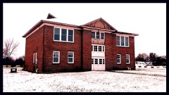 | Lincoln School | building | 1996 | 96000060 |
 | Ross House | building | 1978 | 78001637 |
 | Arthur Simmons Stables Historic District | district | 2004 | 04001286 |
The NOAA Storm Events Database holds 346 reports for this county, causing 1 death, 1 injury and about $5,975,030 in recorded property damage. Each settlement page carries the reports that name it.
| Kind of event | Reports |
|---|---|
| Thunderstorm Wind | 154 |
| Hail | 123 |
| Flash Flood | 34 |
| Tornado | 26 |
| Flood | 5 |
| Lightning | 3 |
| Heavy Rain | 1 |
The most serious of them, by death, then injury, then recorded damage. The accounts are quoted exactly as the forecast office filed them.
| When | Event | Place named | Harm | What the report says |
|---|---|---|---|---|
| June 2024 | Thunderstorm Wind | Vandalia | 1 killed, $50,000 | One direct fatality occurred 5 miles north of Martinsburg when an old, dilapidated barn on Highway 54 collapsed on an individual seeking shelter from the thunderstorm. Large trees and tree limbs were blown down in Vandalia, Laddonia, and Mexico. Siding was also blown off a church south of Mexico Airport (MYJ), power poles were knocked down by tree limbs in Vandalia, and a roof was blown off a trailer in Laddonia. Other communities in the storm's path are Scott's Corner, Rush Hill, and Martinsburg. |
| February 2001 | Flood | Countywide | 1 hurt | no account filed |
| September 1993 | Tornado (F2) | Martinsburg to | $5,000,000 | A tornado with an intermittent damage track first touched down in Martinsburg where many windows were shattered and numerous large trees were blown down. The county sheriff office reported the heaviest damage in a well defined path through town. The tornado crossed into Montgomery County at about 1655 CST. In Wellsville, two eye witnesses saw a tornado approach from the northwest and split into two funnels. The tornado uprooted trees which fell on several cars and houses. A few cars were crushed. A roof off the Kiddie Kastle Day Care Center along Highway 19 was ripped off and deposited between 200 and 250 yards downwind. Extensive damage to houses occured mainly in the southeast part of town. Strong winds from the tornado tore the roof off at least two houses. A wind gust to 90 mph was reported in town but it us unknown if it was directly associated with the tornado. To the east of Wellsville, the tornado apparently tore the roof off a barn near the intersection of Highway 161 and County Road CC before lifting. No one was injured. |
| June 1984 | Tornado (F1) | not stated | $250,000 | no account filed |
| June 1970 | Tornado (F3) | not stated | $250,000 | no account filed |
| April 2025 | Tornado (EF1) | Worchester | $60,000 | A brief tornado tracked south to north just west of Highway MM in north-central Audrain County, destroying a couple of outbuildings and rolling two smaller grain bins. Debris was generally thrown northward and strewn widely, likely due to a downburst immediately following the tornado. The tornado was rated EF-1 with a path length of 0.32 miles and a maximum path width of 50 yards. |
| July 2025 | Flash Flood | Carroll | $60,000 | Heavy rain caused numerous roads to become impassable in Audrain County. These include Highway 54 in Farber, two unnamed roads north of Laddonia, many roads in Laddonia proper, Highway BB just west of Highway W near Middletown, and Highway J at Highway B north of Rush Hill. A water rescue was completed on Highway 54 between Farber and Bassinger Corner. Another vehicle was stuck in water in front of the POET Biorefinery. A third vehicle was stuck in water on Highway 19 in Martinsburg. |
| March 2025 | Tornado (EF1) | Martinsburg | $50,000 | In Madison County, the tornado mostly caused tree damage. The only structural damage was to a residence and an outbuilding on Highway C. From there, the tornado continued northeast before dissipating between the St. Francois River and Madison 418 at approximately 10:57 PM. In Madison County the tornado was rated EF-1 with a path length of 6.75 miles and a maximum path width of 770 yards. |
| June 2022 | Thunderstorm Wind | Mexico | $50,000 | Widespread wind damage between Mexico and Laddonia with numerous trees, tree limbs, as well as power lines blown down. In Mexico, a house sustained moderate roof damage from a fallen tree. Just southwest of Laddonia, a large tree was blown down onto Highway KK, blocking both lanes. Also, several signs were blown down in Mexico. |
| September 1993 | Thunderstorm Wind | Mexico | $50,000 | Strong winds downed trees and power lines in nearby areas ofthe county. |
| July 2008 | Flash Flood | Thompson | $31,000 | Between 4 and 5 inches of rain fell in a short amount of time on already saturated soils causing flash flooding. Numerous roads were flooded including Highway 54 in various places between Vandalia and Mexico. |
| December 1966 | Tornado (F2) | not stated | $25,000 | no account filed |
| June 1960 | Tornado (F1) | not stated | $25,000 | no account filed |
| April 1954 | Tornado (F1) | not stated | $25,000 | no account filed |
| July 2021 | Thunderstorm Wind | Laddonia | $12,000 | Widespread wind damage between Laddonia, Rush Hill and Mexico. One tree was blown down onto Route KK just west of Highway 19. Another tree was blown down onto Route B at 6th Street in Rush Hill. A two foot diameter tree was blown over onto Central Street in Mexico. Also, numerous tree limbs, power lines and power poles were blown over. |
| August 2021 | Thunderstorm Wind | Mexico | $10,000 | Thunderstorm winds blew down numerous tree limbs around Mexico and areas to the south and southeast of town. |
| August 1993 | Thunderstorm Wind | Mexico | $5,000 | A local newspaper reported numerous trees, limbs, and power lines down. Several parked cars received damage from limbs and power outages were common. |
| February 2000 | Thunderstorm Wind | Mexico | $5,000 | no account filed |
| May 1996 | Thunderstorm Wind | Vandalia | $5,000 | no account filed |
| June 1971 | Tornado (F0) | not stated | $2,500 | no account filed |
| July 1965 | Tornado (F1) | not stated | $2,500 | no account filed |
| April 1954 | Tornado (F1) | not stated | $2,500 | no account filed |
| December 2021 | Thunderstorm Wind | Worchester | $2,000 | Thunderstorm winds blew down a tree onto Highway J near the intersection with Highway B. |
| June 2013 | Flood | Martinsburg | $2,000 | no account filed |
| June 1995 | Thunderstorm Wind | Mexico | $300 | Several utility poles and lines were blown down. |
| June 1995 | Thunderstorm Wind | Thompson | $200 | Large trees were blown down over extreme western parts of the county. |
| June 1961 | Tornado (F0) | not stated | $30 | no account filed |
| April 2026 | Thunderstorm Wind | Ortiz | - | Thunderstorm winds downed several trees in a forest on Heckemeyer Road. Additional tree damage was reported on Dawson Road. The storm continued northeast where it downed several large trees near Falcon Lane and Route M in Wardsville. |
| April 2026 | Hail | Mexico | - | A picture of a hailstone compared with a quarter was received. |
| March 2025 | Hail | Ortiz | - | Quarter sized hail fell about halfway between Auxvasse and Mexico. |
| May 2025 | Thunderstorm Wind | Martinsburg | - | Thunderstorm winds downed several trees and power lines across Franklin County. Several vehicle accidents along I-44 were reported at this time as well. |
| April 2025 | Thunderstorm Wind | Vandalia | - | The Vandalia Agricultural Site measured a thunderstorm wind gust of 63 mph. |
| August 2025 | Thunderstorm Wind | Mexico | - | Thunderstorm winds downed many tree limbs which took down powerlines. Winds caused roof damage to two buildings. |
| May 2023 | Thunderstorm Wind | Mexico Mem Arpt | - | Thunderstorm winds blew down several large tree limbs. |
| July 2023 | Thunderstorm Wind | Mexico | - | Thunderstorm winds blew down several large tree limbs and power lines around town. One large tree limb landed on a house causing minor roof damage. |
| April 2023 | Hail | Mexico | - | A wide swath of large hail fell across Audrain County from just west of Mexico northeastward to Vandalia. Large hail was also reported in Laddonia and Farber. |
| March 2023 | Hail | Mexico | - | A long swath of large hail up to golfball size fell across Audrain County between Mexico and Vandalia. Large hail was also reported in Laddonia, Vandiver, Rush Hill, Benton City, and Farber. |
| August 2023 | Thunderstorm Wind | Mexico Mem Arpt | - | The AWOS at Mexico Memorial Airport measured a gust of 61 mph along the leading edge of a bowing segment independent from the primary line of storms. |
| August 2023 | Thunderstorm Wind | Scotts Corner | - | Numerous large maple trees sustained damage with one tree blown over and another split in half. This occurred as a bowing segment largely independent of the primary line of storms passed over the location. |
| July 2023 | Thunderstorm Wind | Mexico | - | Thunderstorm winds caused widespread damage across Mexico and Vandiver. Several trees were blown down as well a power lines and numerous tree limbs. |
| July 2022 | Flash Flood | Skinner | - | Up to 7 inches of rain fell in a 6 to 10 hour period with the heaviest rain across the southern half of Audrain County. Numerous roads were flooded including U.S. Business 54, East Liberty Road at Reading Farms, South Morris Street, Lakeview Road at Elmwood Road, Fairground Road and Park Crest Road. Four vehicles were stranded on the flooded roadways. All of the vehicle occupants were moved to safety and no injuries were reported. |
| June 2021 | Thunderstorm Wind | Mexico | - | Thunderstorm winds blew down numerous tree limbs around Mexico and Laddonia. In Mexico, one large tree limb landed on a parked car causing moderate damage. Also, a small metal storage shed was blown onto the roadway near Holt Street and Martin Luther King Drive. In Laddonia, a large two foot diameter tree was blown over taking down several nearby power lines. |
| June 2021 | Flash Flood | Ortiz | - | Up to 4 inches of rain fell in a short amount of time causing flash flooding. Numerous roads were flooded across the southern half of the county. |
| June 2021 | Thunderstorm Wind | Thompson | - | Thunderstorm winds blew down a 31 foot by 70 foot pole barn, with the debris blown south across the roadway two miles west northwest of Thompson. Also, several power lines were blown down between Thompson and the Audrain/Callaway County line. |
| June 2021 | Thunderstorm Wind | Molino | - | Thunderstorm winds blew down numerous tree limbs. Also, in Farber some shingles were blown off of the roof of a house on west side of town. |
| June 2020 | Flash Flood | Ortiz | - | Up to five inches of rain fell in about a 3 hour period causing flash flooding. Numerous roads were flooded including State Highway D at intersection with County Road 947, County Road 917 south of Highway D, County Road 919 north of Highway D, and intersection of Highways T and E. A water rescue was performed on Highway T west of Highway 15. |
| June 2019 | Thunderstorm Wind | Mexico | - | Thunderstorm winds blew down several large tree limbs. |
| June 2019 | Thunderstorm Wind | Mexico | - | Thunderstorm winds blew down numerous trees, tree limbs and several power lines around town. |
| June 2019 | Flash Flood | Larrabee | - | Up to four inches of rain fell in a short amount of time onto already saturated soils. This caused widespread flash flooding with numerous roads across the county flooded. |
| June 2019 | Thunderstorm Wind | Benton City | - | Thunderstorm winds uprooted a large tree in town. |
| May 2019 | Thunderstorm Wind | Mexico | - | Thunderstorm winds blew down numerous large tree limbs around town. |
| May 2019 | Thunderstorm Wind | Vandalia Arpt | - | Thunderstorm winds blew down several power lines and tree limbs along Highway WW south of Vandalia. |
| May 2019 | Tornado (EF0) | Worchester | - | A weak tornado briefly spun up near the intersection of Highway J and Bean Creek in Audrain County, causing some tree damage. The tornado quickly moved to the NNW, where it caused extensive damage to a barn and damaged more trees. It continued to track to the NNW crossing Audrain Road 350, blowing down more trees and tree limbs before lifting and dissipating. Overall the tornado was rated EF0 with a path length of 0.83 miles and a max path width of 150 yards. No deaths or injuries were reported. |
| May 2019 | Thunderstorm Wind | Bassinger Corner | - | Thunderstorm winds blew down a corrugated barn that was open on both ends, as well as uprooting a large tree and snapping off numerous tree limbs on a farmstead. |
| May 2019 | Thunderstorm Wind | Francis | - | Thunderstorm winds damaged a barn and blew down numerous tree limbs about 7 miles west northwest of Rush Hill. |
| May 2019 | Thunderstorm Wind | Farber | - | Thunderstorm winds blew off a large portion of the roof of a barn, bent a large TV antenna and snapped off several large trees on a farmstead. |
| May 2018 | Thunderstorm Wind | Mexico | - | In Mexico, thunderstorm winds blew down a large tree which also took down some power lines. A church nearby sustained minor roof damage. |
| May 2018 | Thunderstorm Wind | Farber | - | Thunderstorm winds blew down numerous large tree limbs in the eastern portions of Audrain County, especially near the intersection of Highways W and K and on County Road 532. |
| August 2018 | Thunderstorm Wind | Mexico | - | A wide swath of damaging winds occurred over Audrain County from just north of Mexico southeastward towards Vandiver and Martinsburg. Numerous trees, tree limbs and power lines were blown down. Also, an outbuilding just east northeast of Vandiver sustained roof damage. |
| July 2017 | Thunderstorm Wind | Bassinger Corner | - | Thunderstorm winds blew down numerous trees across the eastern half of Audrain County. |
The Survey's mineral resources record lists 71 workings inside this county. 4 still produce and 67 are closed or unrecorded. Each settlement page carries the workings within five miles of it.
| Commodity | Workings |
|---|---|
| Clay | 60 |
| Stone, Crushed/Broken | 5 |
| Sand and Gravel, Construction | 4 |
| Coal, Stone, Crushed/Broken | 1 |
| Fire Clay (Refractory) | 1 |
The least common of them first, because a county's hundredth gravel pit says nothing its first ten did not.
| Where | Site | Commodity | Status | Recorded |
|---|---|---|---|---|
| Northern Fire Clay District | Fire Clay (Refractory) | Unknown | ||
| Unk | Coal, Stone, Crushed/Broken | Past Producer | ||
| Unk | Sand and Gravel, Construction | Past Producer | ||
| Unk | Sand and Gravel, Construction | Past Producer | ||
| Unk | Sand and Gravel, Construction | Past Producer | ||
| Unk | Sand and Gravel, Construction | Past Producer | ||
| Martinsburg Limestone Mill | Stone, Crushed/Broken | Producer | ||
| Unk | Stone, Crushed/Broken | Past Producer | ||
| Unk | Stone, Crushed/Broken | Past Producer | ||
| Unk | Stone, Crushed/Broken | Past Producer | ||
| Unk | Stone, Crushed/Broken | Past Producer | ||
| Adzell Mines | Clay | Unknown | ||
| Blum Pits | Clay | Past Producer | ||
| Erdel Pit | Clay | Past Producer | ||
| Farber Plant | Clay | Producer | ||
| Hafner Pit | Clay | Past Producer | ||
| Hammett Pit | Clay | Past Producer | ||
| Havenor Pit | Clay | Past Producer | ||
| Highes Mine | Clay | Past Producer | ||
| Hook Pit | Clay | Past Producer | ||
| Hook-Leader Pit | Clay | Past Producer | ||
| Hushman Pit | Clay | Past Producer | ||
| Jones Pit | Clay | Past Producer | ||
| Laclede Pit | Clay | Past Producer | ||
| Mexico Plant + Main Office | Clay | Unknown | ||
| Mine Number Fifty-Two | Clay | Past Producer | ||
| Mine Number Six | Clay | Past Producer | ||
| Pit Number Four | Clay | Past Producer | ||
| Pit Number Twelve | Clay | Past Producer | ||
| Snook Pit | Clay | Past Producer | ||
| Todd Pit | Clay | Past Producer | ||
| Unk | Clay | Past Producer | ||
| Unk | Clay | Past Producer | ||
| Unk | Clay | Past Producer | ||
| Unk | Clay | Past Producer | ||
| Unk | Clay | Past Producer | ||
| Unk | Clay | Past Producer | ||
| Unk | Clay | Past Producer | ||
| Unk | Clay | Past Producer | ||
| Unk | Clay | Past Producer | ||
| Unk | Clay | Past Producer | ||
| Unk | Clay | Past Producer | ||
| Unk | Clay | Past Producer | ||
| Unk | Clay | Past Producer | ||
| Unk | Clay | Past Producer | ||
| Unk | Clay | Past Producer | ||
| Unk | Clay | Past Producer | ||
| Unk | Clay | Past Producer | ||
| Unk | Clay | Past Producer | ||
| Unk | Clay | Past Producer | ||
| Unk | Clay | Past Producer | ||
| Unk | Clay | Past Producer | ||
| Unk | Clay | Past Producer | ||
| Unk | Clay | Past Producer | ||
| Unk | Clay | Past Producer | ||
| Unk | Clay | Past Producer | ||
| Unk | Clay | Past Producer | ||
| Unk | Clay | Past Producer | ||
| Unk | Clay | Past Producer | ||
| Unk | Clay | Past Producer | ||
| Unk | Clay | Past Producer | ||
| Unk | Clay | Past Producer | ||
| Unk | Clay | Past Producer | ||
| Unk | Clay | Past Producer | ||
| Unk | Clay | Past Producer | ||
| Unk | Clay | Past Producer | ||
| Unknown - Clay | Clay | Past Producer | ||
| Vandalia Brick Plant Pit | Clay | Past Producer | ||
| Vandalia Plant | Clay | Producer | ||
| Vandalia Works | Clay | Producer | ||
| Walsh - Clarke Pit | Clay | Past Producer |
History of Audrain County, Missouri : Written and Compiled from the Most Authentic Official and Private Sources, Including a History of Its Townships, Towns and Villages; Together with ... Biographical Sketches of Prominent Citizens .. devotes a chapter to each township: its boundaries and streams, who settled it and when, the mills, the schools and the churches. All 5 are reproduced here in full. Each row shows the township's own shape and where it lies in the county, drawn from the Census Bureau's boundary. Which settlements belong to which township is computed from that same boundary, not taken from the book.
| Shape and position in the county | Township | Settlements in it | Length | Sections |
|---|---|---|---|---|
| Cuivre Township | Farber, Hickory Creek, Vandalia | 2,779 words | 4 | |
| Linn Township | Culiver, Rices Corner, Rush Hill, Scotts Corner | 992 words | 1 | |
| Loutre Township | Benton City, Martinsburg | 1,115 words | 3 | |
| Prairie Township | Bassinger Corner, Laddonia, Worcester | 4,646 words | 3 | |
| Salt River Township | Champ, Mexico, Molino, Ortiz | 20,316 words | 44 |
One book written about this county, cut here where the book itself is cut, at its printed chapters: 24 chapters in all. Every chapter is public domain, machine-read from the scan and reproduced complete. A chapter already given under one of the county's towns is not repeated in this list.
Named settlements recorded in the Geographic Names Information System, each with the topographic sheets covering it. Villages, hamlets and abandoned places alike. Each is shown with the nearest named watercourse or landform and the survey quadrangle it falls on.
Cuivre township · 63382 · On Lost Creek · Vandalia Lake quadrangle
16 sheets, 1890 to 1986
No longer a settlement
Salt River township · 65265 · On Davis Creek · Mexico West quadrangle
17 sheets, 1890 to 1986
Salt River township · 65265 · Auxvasse quadrangle
16 sheets, 1890 to 1986
No longer a settlement
South Fork township · 65265 · On Long Branch · Mexico East quadrangle
17 sheets, 1890 to 1986
The vanished settlements of Audrain County: the places named above that are no longer on the map.