 Block
From the record
5 National Register listings published here.
Sources: the county history on the Internet Archive · the National Register database, National Park Service
66 topographic sheets cover 66 settlements here, and 5 properties are on the National Register of Historic Places.
5 National Register listings published here.
Sources: the county history on the Internet Archive · the National Register database, National Park Service
Every property in this county listed on the National Register of Historic Places, with the year it was listed and the federal nomination document.
| Photograph | Property | Type | Listed | Reference |
|---|---|---|---|---|
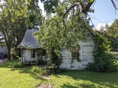 | Charles and Bettie Birthright House | building | 2009 | 09000857 |
| Campbell Commercial Historic District | district | 1991 | 91001482 | |
 | Ely and Walker Shirt Factory No. 5 | building | 2008 | 07001319 |
| Kennett City Hall and Masonic Lodge | building | 1981 | 81000333 | |
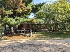 | Given Owens House | building | 1983 | 83000987 |
The NOAA Storm Events Database holds 442 reports for this county, causing 3 deaths, 39 injuries and about $36,446,960 in recorded property damage. Each settlement page carries the reports that name it.
| Kind of event | Reports |
|---|---|
| Thunderstorm Wind | 213 |
| Hail | 149 |
| Tornado | 39 |
| Flash Flood | 33 |
| Flood | 4 |
| Heavy Rain | 3 |
| Lightning | 1 |
The most serious of them, by death, then injury, then recorded damage. The accounts are quoted exactly as the forecast office filed them.
| When | Event | Place named | Harm | What the report says |
|---|---|---|---|---|
| November 1973 | Tornado (F2) | not stated | 2 killed, $250,000 | no account filed |
| December 2015 | Flood | Wilhelmina | 1 killed | A person drowned when attempting to swim in the St. Francis River while it was flooded. |
| April 1981 | Tornado (F4) | not stated | 26 hurt, $25,000,000 | no account filed |
| February 2018 | Tornado (EF2) | Wilhelmina | 5 hurt, $2,000,000 | The tornado tracked from Clay County, AR to Dunklin County. Most of the damage was in Malden where a number of homes were damaged. A few homes, trees and power poles were damaged from the St. Francis River to Malden. The path was intermittent. The tornado crossed into New Madrid County and then lifted. Estimated peak wind along the entire track was 115 mph. |
| April 1973 | Tornado (F2) | not stated | 2 hurt, $25,000 | no account filed |
| March 1964 | Tornado (F2) | not stated | 2 hurt, $25,000 | no account filed |
| November 1984 | Thunderstorm Wind | not stated | 2 hurt | no account filed |
| January 1957 | Tornado (F1) | not stated | 1 hurt, $25,000 | no account filed |
| April 1985 | Thunderstorm Wind | not stated | 1 hurt | no account filed |
| December 2021 | Tornado (EF3) | Hornersville Mem Arp | $1,500,000 | The tornado crossed from Mississippi County, Arkansas into Dunklin County, Missouri near the Little River area south of Hornersville, near the Arkansas/Missouri state line. Several homes and mobile homes were heavily damaged or destroyed along State Line Road. Several vehicles and a boat were tossed or overturned. Additional debarking of trees was noted. After exiting the Little River area, the tornado damaged six metal electric transmission line towers. Five of the towers had their top sections collapse, and one tower completely collapsed. Several center pivot irrigation systems were overturned. The tornado then crossed into Pemiscot County, Missouri. Peak winds in Dunklin County were estimated at 140 mph. |
| April 2018 | Tornado (EF1) | Arbyrd | $1,500,000 | The tornado developed near the intersection of County Roads 627 and 638 and moved east. The tornado damaged storage buildings, trees, power poles, and center pivot irrigation systems. A few residences also experienced shingle and roof damage. The tornado turned northeast after crossing State Highway K. The most significant damage was noted along County Road 657 south-southwest of Hornersville. The tornado dissipated in the Hornersville Swamp Conversation Area. |
| April 2006 | Tornado (F3) | Senath | $1,500,000 | The tornado tracked east out of Greene County, Arkansas into Dunklin County, Missouri. The tornado then continued east into Pemiscot County, Missouri. Seven homes were destroyed and thirty-three homes were damaged. |
| May 2011 | Flood | Glennonville | $500,000 | Heavy rains during late April into the beginning of May caused the St. Francis River to reach near record levels. The river remained above flood stage through the end of the month. Numerous roads were flooded and/or damaged. Several homes and businesses sustained minor damage due to flooding. Several agriculture fields were flooded. The town of Hornersville was flooded. In addition, the town of Wilhelmina was evacuated due to flood waters. |
| March 2025 | Tornado (EF1) | Octa | $350,000 | A tornado touched down shortly before 1 AM CDT along State Highway A between County Roads 516 and 526. The tornado moved northeast, causing multiple irrigation pivots to be overturned, downing numerous power poles, and snapping trees southwest of Kennett. Numerous homes suffered roof damage north of US Highway 412 and the South Bypass, along State Route VV, East 7th Street, and South Anthony Street. As the tornado crossed the intersection of Highway 412 and Highway 25, additional wooden power poles were damaged, trees were uprooted, and damage was caused to several businesses and a motel. Some homes had roof damage on Seely Street and Legion Street. The tornado continued northeast, with additional irrigation pivots overturned. A small barn outbuilding was destroyed as the tornado crossed the Dunklin and Pemiscot County line. Peak winds were estimated at 110 mph. |
| May 2020 | Thunderstorm Wind | Campbell | $300,000 | A macroburst struck portions of Dunklin County with widespread wind damage from Campbell to Clarkton. Numerous trees and power lines were knocked down. There was significant damage to a building in Campbell. A warehouse suffered major damage in Clarkton and a center pivot irrigation system was overturned. The Lynn Oak Church also suffered damage. A train was derailed along Highway 62 near the Arkansas state line, closing the highway. |
| April 2022 | Tornado (EF0) | Hornersville Mem Arp | $260,000 | This tornado began just south of County Road West County Road 70 in the Garson area causing damage to hardwood trees. As the tornado moved northeast across agricultural land, several center pivot irrigation systems were rolled. The tornado crossed into Dunklin County near County Road 645, damaging a mobile home unit and additional center pivot irrigation systems along Missouri Route K and County Road 626. An outbuilding was damaged along County Road 655 with the tornado lifting as it moved into Hornersville. Peak winds were estimated at 85 mph. Thanks to NSSL for assistance with this damage survey. |
| April 2017 | Tornado (EF1) | Hornersville | $250,000 | Damage to roofs. Some sheds and outbuildings destroyed. Roof on a abandoned school collapsed. Tractor trailer overturned at the intersection of Highway 164 and route N. Large brick building was destroyed. There was a house with windows blown out and a tree on a house. Peak winds were estimated at 90 mph. |
| April 1985 | Tornado (F1) | not stated | $250,000 | no account filed |
| May 1973 | Tornado (F1) | not stated | $250,000 | no account filed |
| March 1955 | Tornado (F2) | not stated | $250,000 | no account filed |
| April 2014 | Flash Flood | Wilhelmina | $200,000 | Very heavy rain fell across Northern Dunklin County. 8.50 inches of rain was recorded. Many roads were flooded across Northern Dunklin County especially in the communities of Campbell and Malden. Several homes and businesses were flooded in Malden. An apartment complex in Campbell was flooded with water up to four feet deep. Fifteen residents were rescued from the complex. Several homes were flooded in Campbell as well resulting in additional water rescues. |
| April 2023 | Thunderstorm Wind | Malden | $150,000 | Straight-line winds uprooted numerous trees around downtown Malden. A funeral home suffered roof and wall damage. Numerous homes had roof damage. A shed was destroyed. |
| March 2026 | Tornado (EF0) | Clarkton | $125,000 | A tornado touched down just east of Baird between County Roads 316 and 320 overturning multiple center pivots. The tornado continued into the town of Clarkton, causing roof damage to a state school, convenience store, and multiple homes along Page Street just south of W Highway 162. Additional damage was noted to an outbuilding south of E Highway 162, with debris spreading into a nearby field. The tornado lifted just before the town of Gideon. |
| April 2017 | Thunderstorm Wind | Kennett Mem Arpt | $100,000 | Numerous power lines down between Kennett and Hayti along Highway 412. In addition, several back roads have power lines, power poles and debris from houses covering them. |
| September 2012 | Tornado (EF0) | Bucoda | $100,000 | A tornado briefly touched down near the intersection of Highway N and US Highway 412 near Bucoda. A farm shed was damaged as well as the equipment inside. |
| June 2019 | Thunderstorm Wind | Cardwell | $75,000 | Power lines and trees down in Cardwell. Four streets were blocked. A roof was blown off a building. Several houses had roof and siding damage. Several utility poles were knocked down across southern Dunklin County. A church steeple was blown off in Hornersville. |
| April 2006 | Thunderstorm Wind | Kennett | $75,000 | Straight lined winds blew trees and power lines down near Kennett. Three buildings were damaged. Two houses on county roads 508 and 551 sustained major damage. Irrigation equipment was also blown over. |
| March 2017 | Thunderstorm Wind | Campbell | $50,000 | Large metal building destroyed. One vehicle and trailer damaged by flying debris. |
| January 2008 | Thunderstorm Wind | Cardwell | $50,000 | Straight line winds tore roofs off houses while damaging outbuildings and knocking down trees. |
| November 2000 | Thunderstorm Wind | Holcomb | $50,000 | Several mobile homes were destroyed. A couple of carports were also destroyed. Some trees and power lines were blown down. |
| October 2007 | Thunderstorm Wind | Senath | $40,000 | Straight line winds knocked down trees and power lines in Senath. In addition, roofs were blown off several buildings. |
| June 1999 | Thunderstorm Wind | Kennett | $35,000 | A hangar at the Kennett Municipal Airport was blown down. Numerous trees, power lines and signs were knocked down. |
| June 2018 | Thunderstorm Wind | Bucoda | $30,000 | A big tree was blown down on a Deputy Sheriff's car oh Highway V west of County Road 621. |
| March 2017 | Thunderstorm Wind | Malden | $30,000 | High winds caused roof damage and some trees down in town. |
| May 2012 | Thunderstorm Wind | Clarkton | $30,000 | Straight line winds extensively damaged a roof of a school. |
| January 1999 | Thunderstorm Wind | Campbell | $30,000 | An anchored mobile home was blown over near Campbell. A tractor trailer was blown over and an outbuilding was damaged near Kennett. |
| May 2006 | Thunderstorm Wind | Kennett | $27,000 | A trailer was blown off its foundation and several trees were knocked down by straight line winds. |
| April 2025 | Tornado (EF1) | Glennonville | $25,000 | The tornado crossed from Butler County, Missouri, over the St Francis River, and into far northwest Dunklin County for a brief time before lifting. A couple of homes received minor roof damage and numerous trees were uprooted in Dunklin County. Estimated peak winds were around 95 mph in Dunklin County. |
| February 2023 | Thunderstorm Wind | Malden Arpt | $25,000 | Straight-line winds damaged the roof of a building at the Malden airport. A small pump station was also damaged a few hundred yards east of the airport. |
| April 2008 | Thunderstorm Wind | Malden | $25,000 | Straight line winds knocked over an irrigation pivot along Highway 25 between Malden and Kennett. |
| April 2006 | Thunderstorm Wind | Malden | $25,000 | Straight line winds caused damage to a building and the Malden Airport. Some campers were rolled. Trees were uprooted. |
| September 2006 | Thunderstorm Wind | Malden | $25,000 | Straight line winds blew trees down just north of Malden. One tree was 3 feet in diameter. In addition, a few roofs were blown off of homes. Some damage was also reported at the Malden Regional Airbase and Industrial Park. Fallen trees and debris were common sights at the Airbase after the storm, including a large tree which was found on top of a school bus and another on top of a home. |
| January 2000 | Thunderstorm Wind | White Oak | $25,000 | Some grain tanks and small buildings were blown down. Several shingles were blown off some roofs. Trees and power lines were also knocked down. |
| May 1998 | Thunderstorm Wind | Cardwell | $25,000 | A trailer was rolled over. Several barns and outbuildings were blown down and a couple of roofs were damaged. Several trees were knocked down. |
| August 1981 | Tornado (F1) | not stated | $25,000 | no account filed |
| April 1967 | Tornado (F1) | not stated | $25,000 | no account filed |
| May 1957 | Tornado (F1) | not stated | $25,000 | no account filed |
| April 1954 | Tornado (F2) | not stated | $25,000 | no account filed |
| September 2022 | Thunderstorm Wind | Caruth | $20,000 | Center pivot irrigation unit overturned near a cotton plant off Highway 164. |
| August 2017 | Flash Flood | Kennett Mem Arpt | $20,000 | A restaurant closed due to flash flooding. |
| May 2008 | Tornado (EF0) | Senath | $20,000 | A weak tornado touched down in a field about 2 miles northeast of Senath and flipped over one section a center pivot irrigation system. The tornado then moved across the field and struck a barn causing moderate damage. |
| November 1998 | Thunderstorm Wind | Kennett | $20,000 | Several homes were damaged. A few trees were also knocked down. |
| May 1995 | Hail | Southern Dunklin | $20,000 | Several large tree limbs were blown down. A few of these limbs damaged a home and a car. |
| May 2025 | Thunderstorm Wind | Clarkton | $15,000 | Trees and powerlines down in Clarkton. |
| July 2023 | Thunderstorm Wind | Frisbee | $15,000 | Trees and powerlines were knocked down south of Holcomb. |
| September 2006 | Flash Flood | North Portion | $15,000 | Heavy rains caused some roads over the northern half of Dunklin County to be flooded including Highway 25 and some secondary roads. In the city of Campbell, residents were evacuated due to rising flood waters. Some homes had flood water up to waist high in them. Crops were also severely damaged. |
| July 2005 | Thunderstorm Wind | Malden | $15,000 | A building under construction had its roof blown down. Several trees and power lines were knocked down. |
| June 2004 | Thunderstorm Wind | Kennett | $15,000 | One building was damaged. A trailer was blown around. Some power lines were knocked down. |
| April 2006 | Hail | Kennett | $15,000 | no account filed |
| March 2026 | Thunderstorm Wind | Hornersville | $10,000 | Damage to a porch and garage door. A fence and large tree branches were knocked down. |
The Survey's mineral resources record lists 10 workings inside this county. None of them still produces: all are closed or unrecorded. Each settlement page carries the workings within five miles of it.
| Commodity | Workings |
|---|---|
| Sand and Gravel, Construction | 10 |
The least common of them first, because a county's hundredth gravel pit says nothing its first ten did not.
| Where | Site | Commodity | Status | Recorded |
|---|---|---|---|---|
| Dalton Pit | Sand and Gravel, Construction | Past Producer | ||
| Unk | Sand and Gravel, Construction | Past Producer | ||
| Unk | Sand and Gravel, Construction | Past Producer | ||
| Unk | Sand and Gravel, Construction | Past Producer | ||
| Unk | Sand and Gravel, Construction | Past Producer | ||
| Unk | Sand and Gravel, Construction | Past Producer | ||
| Unk | Sand and Gravel, Construction | Past Producer | ||
| Unk | Sand and Gravel, Construction | Past Producer | ||
| Unk | Sand and Gravel, Construction | Past Producer | ||
| Wetherholt Pit | Sand and Gravel, Construction | Past Producer |
One book written about this county, cut here where the book itself is cut, at its printed chapters: 9 chapters in all. Every chapter is public domain, machine-read from the scan and reproduced complete. A chapter already given under one of the county's towns is not repeated in this list.
| Chapter | Length |
|---|---|
| Chapter 1: Territory of Missouri | 2,902 words |
| Chapter 2: Indians and Other Races the Mound Builders | 2,812 words |
| Chapter 4: The Civil Avar | 1,509 words |
| Chapter 5: Early Settlement | 4,034 words |
| Chapter 6: Churches, Etc | 4,478 words |
| Resources | 1,876 words |
| Chapter 9: Courts, Officials, Etc | 2,237 words |
| Chapter 10: Towns and Villages Caruth | 10,272 words |
| Chapter 11: Politics, Etc | 27,410 words in 2 parts |
Named settlements recorded in the Geographic Names Information System, each with the topographic sheets covering it. Villages, hamlets and abandoned places alike. Each is shown with the nearest named watercourse or landform and the survey quadrangle it falls on.
Independence township · 63857 · Near Cagle Island · Kennett North quadrangle
11 sheets, 1940 to 1984
No longer a settlement
Buffalo township · 63829 · On Seneca Slough · Cardwell quadrangle
14 sheets, 1940 to 1984
Independence township · 63857 · Near Horse Island · Kennett South quadrangle
12 sheets, 1934 to 1984
Buffalo township · 63829 · On Indian Hill Slough · Cardwell quadrangle
14 sheets, 1940 to 1984
Clay township · 63855 · On Old Channel Little River (historical) · Hornersville quadrangle
12 sheets, 1934 to 1984
Independence township · 63857 · On Snipe Slough · Kennett South quadrangle
12 sheets, 1934 to 1984
Clay township · 63855 · On Old Channel Little River (historical) · Hornersville quadrangle
12 sheets, 1934 to 1984
Independence township · 63857 · Near Horse Island · Kennett South quadrangle
12 sheets, 1934 to 1984
Union township · 63933 · Near Bass Island · Piggott quadrangle
11 sheets, 1940 to 1984
The vanished settlements of Dunklin County: the places named above that are no longer on the map.