 Block
From the record
6 National Register listings published here.
Sources: the National Register database, National Park Service
78 topographic sheets cover 35 settlements here, and 6 properties are on the National Register of Historic Places.
6 National Register listings published here.
Sources: the National Register database, National Park Service
Every property in this county listed on the National Register of Historic Places, with the year it was listed and the federal nomination document.
| Photograph | Property | Type | Listed | Reference |
|---|---|---|---|---|
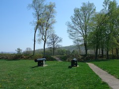 | Fort Davidson | site | 1970 | 70000332 |
 | Immanuel Evangelical Lutheran Church | building | 1979 | 79001364 |
 | Iron County Courthouse Buildings | building | 1979 | 79001363 |
 | Ironton Lodge Hall | building | 2013 | 13000191 |
 | St. Paul's Episcopal Church | building | 1969 | 69000107 |
| Ursuline Academy-Arcadia College Historic District | district | 1998 | 98000816 |
Every wildfire the federal occurrence database records inside this county: 315 of them, burning about 9,474 acres. 3 started naturally and 136 were recorded as arson. Each settlement page carries the fires within five miles of it.
| Reported cause | Fires |
|---|---|
| Arson/incendiarism | 136 |
| Debris and open burning | 86 |
| Missing data/not specified/undetermined | 41 |
| Power generation/transmission/distribution | 20 |
| Equipment and vehicle use | 14 |
| Recreation and ceremony | 8 |
| Natural | 3 |
| Smoking | 3 |
| Railroad operations and maintenance | 2 |
| Misuse of fire by a minor | 2 |
The five largest, by the area the report gives. Five of them were set deliberately.
| Date | Cause | Size | Reported by | Name on the report |
|---|---|---|---|---|
| 3 April 2011 | Missing data/not specified/undetermined | 644 acres | Mark Twain National Forest | BLAIR |
| 28 June 2012 | Arson/incendiarism | 616 acres | Mark Twain National Forest | EAST END |
| 12 April 2006 | Missing data/not specified/undetermined | 542 acres | Mark Twain National Forest | CROOKED TRUCK TRAIL |
| 4 November 2008 | Arson/incendiarism | 414 acres | Mark Twain National Forest | MILL ROCK CREEK |
| 19 March 1995 | Arson/incendiarism | 343 acres | Mark Twain National Forest | NEAL'S CREEK #1 |
| 14 February 1996 | Arson/incendiarism | 287 acres | Mark Twain National Forest | GUNSTOCK |
| 2 April 1997 | Debris and open burning | 280 acres | Missouri Department of Conservation | not named |
| 5 November 2010 | Arson/incendiarism | 238 acres | Mark Twain National Forest | HICKORY GROVE |
Every settlement page carries the fires within five miles of it - see the settlement index below.
The NOAA Storm Events Database holds 222 reports for this county, causing 3 deaths, 27 injuries and about $10,146,300 in recorded property damage. Each settlement page carries the reports that name it.
| Kind of event | Reports |
|---|---|
| Thunderstorm Wind | 88 |
| Hail | 80 |
| Tornado | 27 |
| Flash Flood | 22 |
| Heavy Rain | 2 |
| Flood | 2 |
| Lightning | 1 |
The most serious of them, by death, then injury, then recorded damage. The accounts are quoted exactly as the forecast office filed them.
| When | Event | Place named | Harm | What the report says |
|---|---|---|---|---|
| September 2021 | Thunderstorm Wind | Glover | 1 killed, 1 hurt, $30,000 | A dead tree fell onto a vehicle that was traveling southbound on Highway 21, injuring the driver and killing the passenger. A witness trailing the vehicle reported there was only light wind and rain, as did a Missouri State Trooper. The vehicle was destroyed. |
| May 2002 | Flash Flood | Countywide | 1 killed, $5,500,000 | no account filed |
| November 2024 | Flash Flood | Middle Brook | 1 killed, $60,000 | Flash flooding caused 1 fatality near Knob Creek in Ironton. It also resulted in swift water rescues along County Road 207 in Arcadia and on State Highway C near Annapolis. A car was pushed off a bridge and into the St. Francois River at State Highway U and County Road 31. Water was covering the bridge at the time. |
| July 2001 | Flash Flood | Annapolis | 6 hurt | no account filed |
| December 1967 | Tornado (F4) | not stated | 5 hurt, $2,500,000 | no account filed |
| January 1950 | Tornado (F2) | not stated | 5 hurt, $250,000 | no account filed |
| April 1972 | Tornado (F2) | not stated | 4 hurt, $25,000 | no account filed |
| July 2000 | Lightning | Arcadia | 4 hurt | Four Boy Scouts were injured by a lightning strike while camping on Taum Sauk Mountain, the highest peak in Missouri. The lightning hit a pine tree about 130 feet away. The electricity apparently went through the roots into the boys tent, blowing 4 holes into the bottom of the tent. One boy was knock unconscious. He was not breathing and would likely have died were it not for CPR applied by one of the Scout Leaders. The other boys suffered burns from first to third degree on their backs and arms. |
| March 2025 | Tornado (EF3) | Des Arc | 2 hurt, $800,000 | In Iron County the tornado caused some of its most significant damage in Des Arc where residences were significantly damaged. Two injuries were confirmed here. The tornado continued to track northeast beyond Des Arc where it caused damage to a few more residences, an outbuilding, and numerous trees. It then exited into Madison County. In Iron County the tornado was rated EF-3 with a path length of 7.64 miles and a maximum path width of 800 yards. |
| December 1982 | Tornado (F2) | not stated | $250,000 | no account filed |
| December 2015 | Flash Flood | Brunot | $220,000 | Between 5 and 6 inches of rain fell in a 48 hour period between December 26th and December 28th. There were two waves of rainfall, the second wave caused flash flooding in Iron County. One vehicle became stranded at a low water crossing on County Road 160 just south of Route F, around 545 am on December 28th. The occupant(s) were able to get out, but video from the scene several hours later showed the vehicle being pushed as the current from Brushy Creek became strong enough to lift the SUV and float it downstream. Numerous other roads were flooded including Highway 21 between Routes AA and CC, Highway 221 from Highway 21 through the town of Pilot Knob, Route E over Marble Creek and Route N over the East Fork Black River. |
| March 2008 | Flash Flood | Vulcan | $200,000 | Up to 6 inches of rain fell on already saturated soils in Iron county from the late evening hours of March 17th through March 18th. Numerous roads were covered with water countywide. Also, 8 to 10 homes in Des Arc were flooded and the bridge north of town on Highway 143 was washed out. In the Ironton/Arcadia area, Knob Creek and Stouts Creek were out of their banks and overtopping the bridge that goes over them. Highway D, Highway 21 were impassable in spots and Highway 49 about half a mile south of Highway 72 was flooded. |
| July 1998 | Flash Flood | Countywide | $200,000 | no account filed |
| October 1984 | Tornado (F1) | not stated | $25,000 | no account filed |
| April 1972 | Tornado (F2) | not stated | $25,000 | no account filed |
| May 2024 | Thunderstorm Wind | Belleview | $10,000 | Power lines were downed and there was tree damage in and around Highway 21 and County Road 27 just north of Belleview. Power poles were snapped on Highway 21 just northwest of Pilot Knob. |
| May 2024 | Tornado (EF1) | Vulcan | $10,000 | The tornado continued to track northeast along County Road 149. It snapped off or uprooted numerous trees. Also, a house sustained minor shingle damage to its roof. Then the tornado shifted its track a bit more easterly eventually crossing County Road 147, then Highway 49 around three quarters of a mile north of Vulcan. As it crossed Highway F, 3.5 miles northeast of Vulcan, it uprooted several large trees. Then the tornado track shifted back to a northeasterly direction, crossing County Road 135, about 6 miles northeast of Vulcan, where it uprooted or snapped off several more large trees. Then the tornado crossed into southern Madison County. In Iron County, the path length was 12.05 miles with a max path width of 150 yards with a rating of EF1. |
| April 2023 | Thunderstorm Wind | Goodland | $10,000 | Thunderstorm winds blew down several large trees onto Highway 49. |
| July 2022 | Thunderstorm Wind | Ironton | $10,000 | Thunderstorm winds blew down a large tree on the north side of town. The tree landed on a nearby garage causing moderate damage. |
| April 2008 | Flash Flood | Glover | $5,000 | Up to four inches of rain fell in a short amount of time on already saturated soils. Numerous roads were flooded throughout the county including Highway 21 near Hogan, and Highways C, F and K east and west of Annapolis were closed due to high water over them. A couple of homes in the Ironton and Annapolis areas were surrounded by the high water but did not get water in them. |
| October 1993 | Hail | Annapolis | $5,000 | The county sheriff reported golf ball-size hail west of Annapolis. The local fire department later reported hail up to two inches in diamater and large trees down north of town. |
| October 1993 | Hail | Annapolis | $5,000 | The county sheriff reported golf ball-size hail west of Annapolis. The local fire department later reported hail up to two inches in diamater and large trees down north of town. |
| May 2000 | Tornado (F0) | Annapolis | $3,000 | A small tornado caused damage between Annapolis and Vulcan along Highway 49. One home suffered roof damage and another was damaged by a downed tree. Other damage was limited to downed trees and power lines. |
| September 2007 | Flash Flood | Glover | $1,000 | Two to three inches of rain fell over a short amount of time on ground that was already saturated from previous rains in the past 24 hours. The sheriff's department reported water on Highway 21 north of Glover in the Royal Gorge area. |
| March 1996 | Thunderstorm Wind | Ironton | $1,000 | no account filed |
| May 2024 | Tornado (EF0) | Annapolis | $500 | The tornado tracked east into southern Iron County and then south of Annapolis, where it continued to produce minor tree damage and caused minor damage to the roof panels of a farm outbuilding on County Road 165 and Highway F. From there, the tornado continued into Madison County. The tornado was rated EF0 with a path length of 11.25 miles and a max path width of 167 yards. No deaths or injuries were reported. |
| October 1993 | Thunderstorm Wind | Annapolis | $500 | The county sheriff reported golf ball-size hail west of Annapolis. The local fire department later reported hail up to two inches in diamater and large trees down north of town. |
| July 1995 | Thunderstorm Wind | Iron Mountain | $200 | Several large trees were blown down near Iron Mountain Lake. |
| April 1998 | Hail | Ironton | $100 | no account filed |
| May 2025 | Tornado (EF1) | East End | - | A brief tornado touched down in far northern Iron County where it downed and damaged numerous trees along Highway DD. The tornado then continued into Washington County. |
| May 2025 | Thunderstorm Wind | Pilot Knob | - | Thunderstorm winds downed numerous trees across Ironton and Pilot Knob. |
| May 2025 | Tornado (EF2) | Des Arc | - | An EF-2 tornado touched down in Des ARc and tracked for 3.26 miles. Some buildings damaged by a tornado on March 14th were damaged again by this tornado. |
| April 2025 | Flash Flood | Vulcan | - | The Missouri Department of Transportation has reported multiple road closures in Iron County due to flooding that began on April 3rd. Some of these closures continued into May. Road closures include: Route F from CR 160 to CR 135, Route 40 at Route BB, and Route F from Missouri 49 to CR 165. Over the duration of the event, portions of Iron County received up to 7.5 inches of rain. |
| March 2024 | Thunderstorm Wind | Belleview | - | Thunderstorm winds blew down several powerlines near Belleview. |
| May 2024 | Thunderstorm Wind | Grover | - | Law enforcement reported trees down in southern Iron County near the Reynolds/Iron border. |
| May 2024 | Tornado (EF1) | Arcadia | - | A tornado touched down in the southwestern portion of Arcadia, near the intersection of W. Maple Street and S. Main Street. As it tracked to the east it uprooted or snapped off several large trees as it crossed Highway 21 and tracked along Highway 72. It eventually moved northeast, skirting the south shore of Lake Killarney snapping off more trees before lifting and dissipating near Ozark Drive. Overall, the tornado was rated EF1 with a path length of 4.08 miles and a max path width of 100 yards. No deaths or injuries were reported. |
| May 2024 | Hail | Viburnum | - | Trained spotter and social media reported 2 inch hailstones in and near Viburnum. |
| May 2024 | Tornado (EF0) | Vulcan | - | A tornado touched down 1.8 miles southeast of Annapolis, between Highway 49 and Highway F. As it tracked to the east northeast it uprooted or snapped off several large trees before crossing Highway F, then lifted and dissipated. Overall, the tornado was rated EF0 with a path length of 0.59 miles and a max path width of 75 yards. No deaths or injuries were reported. |
| May 2024 | Tornado (EF1) | Brunot | - | A tornado touched down around 4.5 miles east northeast of Vulcan and tracked to the northeast. As it crossed Highway F it uprooted several large trees. Then as it approached County Road 135 it uprooted or snapped off several more large trees before lifting and dissipating. Overall, the tornado was rated EF1 with a path length of 1.67 miles and a max path width of 150 yards. No deaths or injuries were reported. |
| May 2024 | Thunderstorm Wind | Belleview | - | Law enforcement reported trees down on MO-32 north of Belleview Schools. |
| May 2024 | Tornado (EF1) | Ironton | - | A tornado touched down in Arcadia just west of the intersection of North Main Street and Elm Street. It tracked to the east through town snapping off several large trees. After crossing Russellville Road, it either uprooted or snapped off several more large trees on the Arcadia Valley Golf Club. The tornado then began to track more northeasterly and skirted the north shore of Lake Killarney snapping off even more trees as it crossed Highway 72 then crossed it once again, remaining on the north side of Highway 72 before crossing into Madison County. The tornado was rated EF1 in Iron County with a path length of 5.37 miles and a max path width of 150 yards. |
| May 2024 | Tornado (EF1) | Annapolis | - | A tornado touched down on the west side of Annapolis, just west of County Road 142. As it crossed County Road 142, it uprooted a large tree. It tracked to the east northeast through town. As it approached Tabitha Street it took most of the roof off of a manufactured home just across the street from South Iron High School and South Iron Elementary School. It caused damage to the elementary school with a large section of roof lifted off, several walls blow over, and numerous windows broken. The tornado then crossed Highway 49 with a number of trees either uprooted or snapped off as it tracked to the east northeast. As it approached Highway C, more trees were uprooted before the tornado lifted and dissipated almost 2 miles east northeast of Annapolis. Overall, the tornado was rated EF1 with a path length of 2.56 miles and a max path width of 250 yards. No deaths or injuries were reported. |
| November 2024 | Heavy Rain | Banner | - | The mesonet station in Council Bluff measured 7.94 inches of rain between November 4th and 5th. |
| August 2021 | Thunderstorm Wind | Banner | - | Thunderstorm winds blew down a tree at the intersection of Highway 32 and County Road 41. |
| October 2021 | Tornado (EF1) | Minimum | - | A tornado touched down on south side of County Road 124, 1.3 miles west intersection with Highway E, in southern Iron County. This tornado uprooted several trees and broke branches on numerous other trees before continuing into a field where it damaged a manufactured home. The tornado then moved into a densely wooded portion of Mark Twain National Forest where it uprooted or damaged many trees as it crossed from Iron County, about 8 miles east of Glover, into Madison County. The tornado was rated EF1 with a path length of 4.35 miles and a max path width of 250 yards in Madison County. No deaths or injuries. |
| November 2020 | Thunderstorm Wind | Viburnum | - | Thunderstorm winds blew a large tree over and onto Highway Y on the north side of Viburnum. |
| March 2019 | Thunderstorm Wind | Viburnum | - | Thunderstorm winds blew down several 40 foot tall, one foot diameter oak trees onto Highway 49 just west northwest of Viburnum. |
| June 2019 | Thunderstorm Wind | Viburnum | - | Thunderstorm winds blew down several trees along Highway 49 between Viburnum and Bixby. |
| June 2019 | Flash Flood | Ironton | - | Up to three inches of rain fell in a short amount of time causing flash flooding. Several roads around Pilot Knob were flooded including West Maple Street and Highway 221. |
| October 2019 | Thunderstorm Wind | Ironton | - | Thunderstorm winds blew down several trees along College Street in Arcadia. |
| August 2019 | Thunderstorm Wind | Ironton | - | Thunderstorm winds blew down an 8 inch diameter tree onto Highway D, just east southeast of Arcadia. |
| April 2019 | Tornado (EF1) | Banner | - | A weak short-lived tornado destroyed a farm outbuilding just west of County Road 21. Damage was strewn to the northeast of the track. The tornado was rated EF1 with a path length of 0.06 miles and a max path width of 30 yards. No deaths or injuries occurred with this tornado. |
| December 2018 | Thunderstorm Wind | Belleview | - | Thunderstorm winds blew down several trees onto Highway N near Iron/Reynolds County line. |
| February 2018 | Flash Flood | Vulcan | - | A number of rounds of rain moved through the region over several days. Thus the soils were saturated. Between one and three inches of rain fell in a short amount of time causing flash flooding. Numerous roads were flooded including Highway D just southeast of Arcadia and Highway CC just southwest of Arcadia. |
| June 2018 | Thunderstorm Wind | Ironton | - | Thunderstorm winds blew down several large tree limbs around town. Also, one tree was blown over onto a house causing moderate damage. |
| April 2018 | Hail | Viburnum | - | A wide swath of large hail fell across northern Iron County. One inch hail was reported in Viburnum, Bixby and just south of Council Bluff Lake. |
| June 2018 | Thunderstorm Wind | Ironton | - | Thunderstorm winds blew down several trees along Highway 21 in Arcadia. |
| July 2017 | Flash Flood | Glover | - | Up to three inches of rain fell in a short amount of time causing flash flooding. Several roads were flooded including the south bound lane at the intersection of Highways 21 and 49 on the north side of Glover. |
| May 2017 | Thunderstorm Wind | Viburnum | - | Thunderstorm winds blew down numerous large tree limbs around town. |
| May 2017 | Hail | Sabula | - | A wide swath of large hail fell between Chloride and Annapolis. The largest hail stones were two inches in diameter. |
The Survey's mineral resources record lists 106 workings inside this county. 7 still produce and 99 are closed or unrecorded. Each settlement page carries the workings within five miles of it.
| Commodity | Workings |
|---|---|
| Iron | 29 |
| Stone, Crushed/Broken | 17 |
| Lead | 9 |
| Granite | 9 |
| Manganese | 8 |
| Clay | 7 |
| Limestone, Dimension | 6 |
| Iron, Manganese | 5 |
| Copper | 4 |
| Stone, Dimension | 2 |
| Sulfur, Phosphorus-Phosphates | 1 |
| Cadmium, Silver, Copper, Zinc | 1 |
| Cobalt, Nickel | 1 |
| Zinc, Copper | 1 |
The least common of them first, because a county's hundredth gravel pit says nothing its first ten did not.
| Where | Site | Commodity | Status | Recorded |
|---|---|---|---|---|
| (Facility) Buick Smelter | Lead, Smelter, Silver, Zinc, Smelter, Copper | Plant | ||
| Annapolis Mine | Lead, Zinc, Copper, Nickel, Cobalt | Past Producer | 1865, 1915 | |
| Argentiferrous Lead Mine | Lead, Silver | Past Producer | ||
| Biser Diggings | Feldspar, Iron | Past Producer | ||
| Buick Mine | Zinc, Lead, Cobalt, Silver, Copper, Nickel, Cadmium | Producer | 1960, 1969 | |
| Cuthbertson Mtn Mine | Manganese, Iron | Past Producer | ||
| Glover | Lead, Refiner | Producer | ||
| Magmont Mine | Lead, Cadmium, Silver, Copper, Zinc, Cobalt, Nickel | Producer | 1962, 1968 | |
| Nitre Cave | Nitrogen-Nitrates | Past Producer | ||
| Sheahan Granite Quarry | Tin, Stone, Dimension | Past Producer | 1888 | |
| Shepherd Mountain | Iron, Sulfur, Phosphorus-Phosphates | Past Producer | 1815 | |
| Unknown - Asbestos Prospect | Asbestos | Prospect | ||
| Unknown - Titanium | Titanium | Past Producer | ||
| Benson Quarry | Stone, Dimension | Past Producer | ||
| Unknown - Granite Dimension | Stone, Dimension | Past Producer | ||
| Ketcherside Gap Copper Deposit | Copper | Past Producer | ||
| Unknown - Copper | Copper | Past Producer | ||
| Unknown - Copper | Copper | Past Producer | ||
| Unknown - Copper | Copper | Past Producer | ||
| Buford Mtn | Iron, Manganese | Past Producer | ||
| Buford Mtn Mine | Iron, Manganese | Past Producer | ||
| Cuthbertson's Hill | Iron, Manganese | Occurrence | ||
| John Baird Property | Iron, Manganese | Past Producer | ||
| Unknown - Iron-Manganese | Iron, Manganese | Past Producer | ||
| Hastings Quarry | Limestone, Dimension | Past Producer | ||
| May Quarry | Limestone, Dimension | Past Producer | ||
| Russell Quarry | Limestone, Dimension | Past Producer | ||
| Unknown - Ls | Limestone, Dimension | Past Producer | ||
| Unknown - Ls Dimension | Limestone, Dimension | Past Producer | ||
| Unknown -Ls | Limestone, Dimension | Past Producer | ||
| Burt Mine | Clay | Past Producer | ||
| Kaolin Mine | Clay | Past Producer | ||
| Montana Mine | Clay | Past Producer | ||
| Old Barger Property | Clay | Past Producer | ||
| Unknown - Clay | Clay | Prospect | ||
| Unknown - Clay | Clay | Past Producer | ||
| Unknown - Clay | Clay | Past Producer | ||
| Fred Swearingim Prospect | Manganese | Prospect | ||
| Martin Mine | Manganese | Past Producer | ||
| Russel Property | Manganese | Past Producer | ||
| Unknown - Manganese | Manganese | Prospect | ||
| Unknown - Manganese | Manganese | Past Producer | ||
| Unknown - Manganese | Manganese | Prospect | ||
| Unknown - Manganese | Manganese | Prospect | ||
| Unknown - Manganese | Manganese | Prospect | ||
| Annapolis | Lead | Past Producer | Galena | |
| Central Services | Lead | Unknown | ||
| Graniteville Quarry | Granite | Past Producer | ||
| Graniteville Quarry | Granite | Past Producer | ||
| Graniteville Quarry and Mill | Granite | Producer | ||
| Schneider Quarry | Granite | Past Producer | ||
| Sheanan Bros Quarry | Granite | Past Producer | ||
| Unknown - Granite | Granite | Past Producer | ||
| Unknown - Granite | Granite | Past Producer | ||
| Unknown - Granite | Granite | Past Producer | ||
| Unknown - Granite | Granite | Past Producer | ||
| Unknown - Lead | Lead | Prospect | ||
| Unknown - Lead | Lead | Past Producer | ||
| Unknown - Lead | Lead | Past Producer | ||
| Unknown - Lead | Lead | Prospect | ||
| Unknown - Lead Prospect | Lead | Prospect | ||
| Annapolis Quarry and Mill | Stone, Crushed/Broken | Producer | ||
| Duncan Brothers Quarry | Stone, Crushed/Broken | Past Producer | ||
| Hollman Bros Quarry | Stone, Crushed/Broken | Past Producer | ||
| Jones Quarry | Stone, Crushed/Broken | Past Producer | ||
| Unknown - Lead | Stone, Crushed/Broken | Past Producer | ||
| Unknown - Ls | Stone, Crushed/Broken | Past Producer | ||
| Unknown - Ls | Stone, Crushed/Broken | Past Producer | ||
| Unknown - Ls | Stone, Crushed/Broken | Past Producer | ||
| Unknown - Ls | Stone, Crushed/Broken | Past Producer | ||
| Unknown - Ls | Stone, Crushed/Broken | Past Producer | ||
| Unknown - Ls | Stone, Crushed/Broken | Past Producer | ||
| Unknown - Ls | Stone, Crushed/Broken | Past Producer | ||
| Unknown - Ls | Stone, Crushed/Broken | Past Producer | ||
| Unknown - Ls | Stone, Crushed/Broken | Past Producer | ||
| Unknown - Ls | Stone, Crushed/Broken | Unknown | ||
| Unknown - Ls | Stone, Crushed/Broken | Past Producer | ||
| Unknown - Ls | Stone, Crushed/Broken | Past Producer | ||
| Big Bogg Mtn Mine | Iron | Past Producer | ||
| Buford Mountain | Iron | Past Producer | ||
| Burt Bank | Iron | Occurrence | Surface | |
| Cedar Hill Mine | Iron | Past Producer | 1872 | |
| Cedar Hill Mine | Iron | Past Producer | ||
| Eaton Iron Mine | Iron | Past Producer | ||
| Graves Iron Mine | Iron | Past Producer | ||
| Graves Mine | Iron | Past Producer | 1905, 1906 | |
| Lewis Mountain | Iron | Occurrence | ||
| Lewis Mtn Mine | Iron | Past Producer | ||
| Love Bank | Iron | Past Producer | ||
| Pilot Knob | Iron | Prospect | 1835, 1848 | |
| Pilot Knob Pellet Comp. Mine/Plant | Iron | Producer | ||
| Red Point Land Fe Occurrence | Iron | Occurrence | ||
| Robinson Mine | Iron | Past Producer | ||
| Rogers Bank | Iron | Occurrence | ||
| Russell Mountain | Iron | Past Producer | 1872 | |
| Russell Mtn Mine | Iron | Past Producer | ||
| Shut-In Mine | Iron | Past Producer | 1816 | |
| Shut-In Mine | Iron | Past Producer | ||
| Sligo Iron Mine | Iron | Past Producer | ||
| Smith Land | Iron | Past Producer | ||
| Unknown - Iron | Iron | Past Producer | ||
| Unknown - Iron | Iron | Past Producer | ||
| Unknown - Iron | Iron | Past Producer | ||
| Unknown - Iron | Iron | Past Producer | ||
| Unknown - Iron | Iron | Past Producer | ||
| Unknown - Iron | Iron | Past Producer |
Named settlements recorded in the Geographic Names Information System, each with the topographic sheets covering it. Villages, hamlets and abandoned places alike. Each is shown with the nearest named watercourse or landform and the survey quadrangle it falls on.
Iron township · 63623 · On Townsen Creek · Graniteville quadrangle
24 sheets, 1937 to 1989
Dent township · 63623 · Near Marques Hollow · Viburnum East quadrangle
22 sheets, 1943 to 1999
Arcadia township · 63663 · On East Branch Knob Creek · Ironton quadrangle
25 sheets, 1937 to 2000
Kaolin township · 63623 · On Sam Branch · Johnson Mountain quadrangle
20 sheets, 1924 to 1999
No longer a settlement
Iron township · 63650 · On Charles Creek · Graniteville quadrangle
24 sheets, 1937 to 1989
Dent township · 65565 · Near Payne Hollow · Viburnum East quadrangle
22 sheets, 1943 to 1999
Iron township · 63650 · Near Middlebrook Hill · Graniteville quadrangle
24 sheets, 1937 to 1989
Arcadia township · 63650 · Near Froe Hollow · Lake Killarney quadrangle
25 sheets, 1937 to 2000
Iron township · 63650 · On Middlebrook Hill · Graniteville quadrangle
24 sheets, 1937 to 1989
Arcadia township · 63663 · On East Branch Knob Creek · Ironton quadrangle
25 sheets, 1937 to 2000
Kaolin township · 63623 · On Clayton Creek · Johnson Mountain quadrangle
20 sheets, 1924 to 1999
Arcadia township · 63621 · On Knob Creek · Lake Killarney quadrangle
25 sheets, 1937 to 2000
Kaolin township · 63623 · Near Guyser Hollow · Johnson Mountain quadrangle
20 sheets, 1924 to 1999
No longer a settlement
Arcadia township · 63650 · On Knob Creek · Lake Killarney quadrangle
25 sheets, 1937 to 2000
The vanished settlements of Iron County: the places named above that are no longer on the map.