BlockBefore
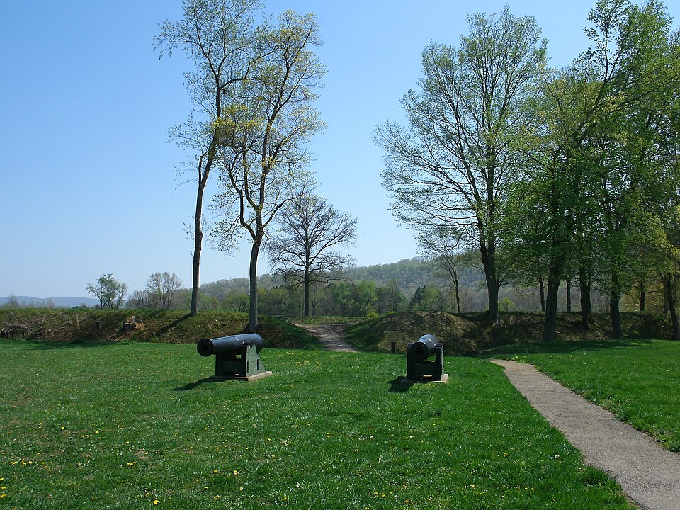
Photograph of Battle of Pilot Knob State Historic Site
Photograph by Kbh3rd, CC BY 3.0. Via Wikimedia Commons.

Fort Davidson

Listed on the National Register of Historic Places in 1970.

From the record

“Fort Davidson, a fortification near the town of Pilot Knob, Missouri, was the site of the Battle of Fort Davidson during the American Civil War. Built by Union Army soldiers during the American Civil War, the fort repulsed Confederate attacks during the Battle of Fort Davidson on September 27, 1864, during Price's Raid.”

Wikipedia article Fort Davidson, CC BY-SA 4.0.

One of 6 National Register listings published here for Iron County · listed in 1970 · category: Site.

Sources: the Wikipedia article · the case file at the National Archives · the National Register database, National Park Service


The listing

  • What is counted as historic. The nomination lists 1 site as contributing to the listing.
  • Address. On MO 21, S of jct. with Rte. V in Clark National Forest, Pilot Knob, 63650
  • When was it listed? February 1970
  • Category. site
  • Township. Arcadia township
  • National Register reference number. 70000332 - the number the National Park Service assigned this property when it was listed, and the key its nomination file is catalogued under at the National Archives.

Fires near this property

29 since 1992

Regional context, not property-specific evidence. The federal wildfire occurrence database lists 29 fires within 5 miles of Fort Davidson between 1992 and 2020, burning about 135 acres in total. None started naturally. 4 were recorded as arson. Distance is straight-line from the map coordinates, so a fire counted here may appear on a neighbouring settlement's page as well.

Reported cause Fires
Debris and open burning16
Missing data/not specified/undetermined6
Arson/incendiarism4
Misuse of fire by a minor2
Recreation and ceremony1

The most recent of them, most recent first, with the day each was reported and the service that recorded it.

DateCause SizeReported by Name on the report
3 September 1996Recreation and ceremony10 acresMissouri Department of Conservationnot named
2 September 1995Debris and open burning2.0 acresMissouri Department of Conservationnot named
9 April 1994Arson/incendiarism1.0 acresMissouri Department of Conservationnot named
7 April 2013Debris and open burning8.3 acresMark Twain National Forest334
4 April 1992Misuse of fire by a minor1.0 acresMissouri Department of Conservationnot named
14 April 1995Missing data/not specified/undetermined1.0 acresMissouri Department of Conservationnot named
10 April 1993Debris and open burning2.0 acresMissouri Department of Conservationnot named
3 March 1992Debris and open burning1.0 acresMissouri Department of Conservationnot named

Every fire recorded in Iron County

Mines and quarries near this property

10 of 32 shown

Regional context, not property-specific evidence. The federal mineral resources record lists 32 workings within 5 miles of Fort Davidson: 27 past producers, 2 prospects, 2 producers, 1 occurrence. 2 still produce. What was taken out: Iron, Granite, Limestone, Dimension, Stone, Crushed/Broken. Distance is straight-line from the map coordinates, so a quarry counted here may appear on a neighbouring settlement's page as well.

Where SiteCommodity StatusRecorded
Sheahan Granite QuarryTin, Stone, DimensionPast Producer1888
Shepherd MountainIron, Sulfur, Phosphorus-PhosphatesPast Producer1815
Unknown - Lead - IronIron, LeadPast Producer
Unknown - Lead ProspectLeadProspect
Jones QuarryStone, Crushed/BrokenPast Producer
Unknown - LsStone, Crushed/BrokenPast Producer
Hastings QuarryLimestone, DimensionPast Producer
Russell QuarryLimestone, DimensionPast Producer
Unknown - Ls DimensionLimestone, DimensionPast Producer

Every working recorded in Iron County

Storms near this property

11 since 2003

Regional context, not property-specific evidence. The National Weather Service names Pilot Knob, the town this property stands in, in 11 storm reports between 2003 and 2025: 6 hail, 2 tornado, 2 thunderstorm wind, 1 flash flood. No death or injury is recorded in these reports. Each account below is quoted exactly as the forecast office filed it, from the NOAA Storm Events Database, and each date opens the federal record of that event.

WhenEvent Place namedHarm What the report says
May 2025Thunderstorm WindPilot Knob-Thunderstorm winds downed numerous trees across Ironton and Pilot Knob.
July 2012Thunderstorm WindPilot Knob-Thunderstorm winds blew down several large trees and powerlines in Pilot Knob.
February 2008Flash FloodPilot Knob-Two to three inches of rain fell over portions of Iron county during the evening hours of February 5th. Water 6 to 12 inches deep was reported on Highway 221 in Pilot Knob at an underpass. Also, several low water crossings were flooded for a time in the area.
September 2006Tornado (F1)Pilot Knob-As the tornado moved into Iron County from Reynolds County, it tracked northeast paralleling Route N for a mile, resulting in a long swath of continuous damage which spanned both sides of the road. Numerous trees were either uprooted or snapped, 5 homes sustained roof and exterior damage, and a mobile home was flipped on its side. The damage path was around a third of a mile wide and was rated high end F1. The tornado then narrowed and moved across the southeast portion of Snow Hollow Lake where trees were snapped and uprooted. Two homes sustained moderate damage due to the tornado and fallen trees. The damage path was about 75 yards wide and was rated F1 in intensity. The tornado continued northeast crossing Highway 21 around a mile north of Pilot Knob. Several homes on each side of the highway and a day care center on the west side received minor roof damage. Trees were also snapped and uprooted. The tornado then crossed Middlebrook Road where one home lost a portion of its roof, a mobile home sustained moderate damage and a machine shed was destroyed. This damage was rated F1 in intensity and was about 100 yards wide. The tornado then moved up the ridge line further east snapping a number of trees half way up. The tornado then crossed Route V around half a mile south of the Iron/St. Francois County line, snapping and topping trees on both sides of the road. The damage path was about 40 yards wide and was rated F1. It appears the tornado lifted just south of the Iron/St. Francois County line around a mile northeast of Route V. No injuries or deaths were reported.
September 2006Tornado (F2)Pilot Knob-The tornado touched down 6 miles west of Pilot Knob on Route N where it destroyed a mobile home and blew down several trees and numerous tree limbs. The damage path was about 40 yards wide and was rated F1 in intensity. The tornado then traveled east towards Snow Hollow Lake. A ranch home was severely damaged along the north side of the lake. The tornado then hit several large trees along the east side of the lake. The damage path was 100 yards wide in this location with F2 intensity. The tornado continued moving to the east for another mile before lifting and dissipating. No injuries or deaths were reported.
March 2020HailPilot Knob-no account filed
March 2012HailPilot Knob-no account filed
April 2006HailPilot Knob-no account filed
September 2006HailPilot Knob-no account filed
May 2003HailPilot Knob-no account filed

Every storm recorded in Iron County

Map coverage status

No historic map-sheet match is published for this property yet. That does not mean no map exists. This record needs a coordinate-quality review before it can be joined to a sheet boundary. Browse the county's mapped places while that work is pending.

Listed places nearby

5 within 8 miles

Other National Register properties close enough to walk or drive between, ordered by distance from this one. Both positions come from the same geocoding pass that matched these properties to their map sheets.

Sources for this property

National Archives recordThe nomination case file for reference 70000332 in Record Group 79.
Wikipedia articleCommunity-written account of this property, licensed CC BY-SA.
Iron CountyAll 6 listed properties in this county.

Provenance

  • Listing record. National Park Service National Register of Historic Places, listed-properties dataset, current to 2026-05-22.
  • Map join. Address geocoded through the United States Census geocoder, then tested against the published boundary of every sheet in the USGS Historical Topographic Map Collection.
  • How this page is made. Listing fields come from federal records; map-sheet coverage is a labelled coordinate-to-boundary calculation, not a source-field claim.
  • Wildfire. Short, Karen C. 2022. Spatial wildfire occurrence data for the United States, 1992-2020 [FPA_FOD_20221014]. 6th Edition. Fort Collins, CO: Forest Service Research Data Archive. https://doi.org/10.2737/RDS-2013-0009.6 Collected with United States Government funding and usable without additional permissions or fees.
  • Mines and quarries. USGS Mineral Resources Data System (MRDS) https://mrdata.usgs.gov/mrds/ A work of the United States government, no copyright under 17 U.S.C. 105.
  • Storms. NOAA National Centers for Environmental Information, Storm Events Database https://www.ncei.noaa.gov/stormevents/ A work of the United States government, no copyright under 17 U.S.C. 105. Narratives are quoted verbatim from the National Weather Service report and are not edited or summarised.