 Block
From the record
9 National Register listings published here.
Sources: the National Register database, National Park Service
143 topographic sheets cover 35 settlements here, and 9 properties are on the National Register of Historic Places.
9 National Register listings published here.
Sources: the National Register database, National Park Service
Every property in this county listed on the National Register of Historic Places, with the year it was listed and the federal nomination document.
| Photograph | Property | Type | Listed | Reference |
|---|---|---|---|---|
| Community Theater | building | 2006 | 06001134 | |
| Headquarters, Rolla Division of the Bureau of Mines | building | 2017 | 100000910 | |
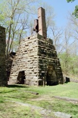 | Maramec Iron Works District | district | 1969 | 69000122 |
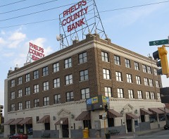 | National Bank of Rolla Building | building | 2001 | 01001380 |
| Ozark Iron Furnace Stack | structure | 1970 | 70000345 | |
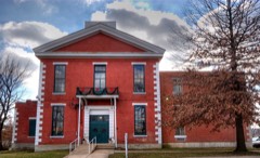 | Phelps County Courthouse | building | 1993 | 92001745 |
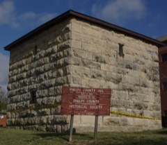 | Phelps County Jail | building | 1990 | 90000766 |
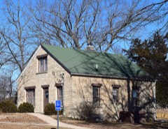 | Rolla Ranger Station Historic District | district | 2003 | 03000717 |
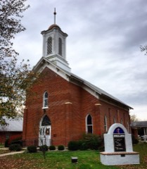 | St. James Chapel | building | 1983 | 83001035 |
Every wildfire the federal occurrence database records inside this county: 593 of them, burning about 8,946 acres. 3 started naturally and 108 were recorded as arson. Each settlement page carries the fires within five miles of it.
| Reported cause | Fires |
|---|---|
| Debris and open burning | 244 |
| Missing data/not specified/undetermined | 168 |
| Arson/incendiarism | 108 |
| Equipment and vehicle use | 22 |
| Recreation and ceremony | 17 |
| Smoking | 15 |
| Railroad operations and maintenance | 9 |
| Misuse of fire by a minor | 4 |
| Natural | 3 |
| Fireworks | 1 |
| Other causes | 1 |
| Power generation/transmission/distribution | 1 |
The five largest, by the area the report gives. Five of them were set deliberately.
| Date | Cause | Size | Reported by | Name on the report |
|---|---|---|---|---|
| 22 April 2007 | Missing data/not specified/undetermined | 1,249 acres | Missouri Department of Conservation | RUNNING BOY |
| 8 March 2000 | Arson/incendiarism | 755 acres | Mark Twain National Forest | CORN |
| 30 March 2005 | Debris and open burning | 592 acres | Mark Twain National Forest | FREEMAN |
| 30 March 2005 | Missing data/not specified/undetermined | 500 acres | Missouri State Fire Marshal's Office | not named |
| 8 April 2019 | Arson/incendiarism | 307 acres | Mark Twain National Forest | BIG PINEY |
| 12 March 2007 | Arson/incendiarism | 273 acres | Mark Twain National Forest | KNOTWELL |
| 3 April 2011 | Arson/incendiarism | 243 acres | Mark Twain National Forest | DARK BOTTOM HOLLOW |
| 17 March 1994 | Arson/incendiarism | 210 acres | Missouri Department of Conservation | not named |
Every settlement page carries the fires within five miles of it - see the settlement index below.
The NOAA Storm Events Database holds 568 reports for this county, causing 2 deaths, 12 injuries and about $20,868,780 in recorded property damage. Each settlement page carries the reports that name it.
| Kind of event | Reports |
|---|---|
| Hail | 203 |
| Thunderstorm Wind | 178 |
| Flash Flood | 71 |
| Flood | 38 |
| Tornado | 35 |
| Heavy Rain | 32 |
| Lightning | 5 |
| Funnel Cloud | 5 |
| Wildfire | 1 |
The most serious of them, by death, then injury, then recorded damage. The accounts are quoted exactly as the forecast office filed them.
| When | Event | Place named | Harm | What the report says |
|---|---|---|---|---|
| December 2010 | Tornado (EF3) | Rolla Downtown Arpt | 2 killed, 6 hurt, $1,000,000 | A NWS survey team determined that an EF-3 tornado occurred north of Rolla. The heaviest damage occurred between state Highway E and County Road 8040. Two single wide mobile homes were completely destroyed with debris thrown upstream while the frames were detached. Two fatalities occurred in one of these homes. A two story home had all but its interior walls destroyed. Several cars were thrown with one vehicle thrown over the destroyed home. Minor to moderate roof and tree damage occurred at various locations near the starting point to Highway 63 north of Rolla. There was primarily tree damage between Highway 63 and Highway 68. |
| September 2006 | Tornado (F1) | St James | 2 hurt, $1,500,000 | A National Weather Service storm survey revealed that a tornado tracked across a section of northeast Phelps County, and through the community of St. James. Several structures were heavily damaged including a Walmart distribution center, the Manchester Packing Plant, and the St. James Middle School. The tornado dissipated three miles east of St. James, just prior to crossing into Crawford County. No injuries occurred from the tornado. |
| March 2025 | Tornado (EF2) | Rolla Downtown Arpt | 1 hurt, $2,500,000 | An EF-2 tornado moved through Phelps County, including the city of Rolla. The tornado started in the Mark Twain National Forest approximately 7 miles southeast of Newburg, MO with damage diminishing to the north of Dillion, MO. The tornado caused an intermittent path of damaged and uprooted trees before causing damage to homes and businesses along Highway 63 south of Rolla then continued to cause damage across southeast sections of Rolla that included significant damage to some homes, roof damage to multiple schools and other businesses. One person was injured across this portion of the path. The damage became more intermittent across eastern sections of Rolla, then became even more sparse as it crossed Interstate 44 at Highway V though still strong enough to damage a barn roof, uproot additional trees, and shifted a mobile home off its piers, and then lifted near Little Prairie Conservation Area to the north of Dillion, MO. At its peak, the tornado reached 500 yards wide and had peak winds estimated at 110-120 mph. |
| April 2002 | Flash Flood | North Portion | 1 hurt, $300,000 | no account filed |
| June 1973 | Tornado (F2) | not stated | 1 hurt, $250,000 | no account filed |
| November 1960 | Tornado (F1) | not stated | 1 hurt, $25,000 | no account filed |
| June 1999 | Tornado (F3) | St James | $3,500,000 | no account filed |
| December 2015 | Flash Flood | Flat | $2,500,000 | Highway J was closed due to high water at the Spring Creek Arm of the Big Piney River. Numerous roads and bridges were damaged. Approximately 8 homes were destroyed and 22 homed suffered moderate damaged from flood water. This storm report will contain the damage estimates for the entire county for this event. |
| May 1978 | Tornado (F2) | not stated | $2,500,000 | no account filed |
| November 2024 | Flood | Beulah | $2,000,000 | Of the $1 million in damages to roads and bridges across the county, the worst damages were located along the Big Piney near Buelah, followed by the Newburg and Duke areas. Additionally, four homes suffered major damages. |
| April 2017 | Flash Flood | Newburg | $1,000,000 | At least 50 homes and business sustained flood damage across the county. Numerous roads and bridges were severely damaged or washed away across the county. This report will contain the total dollar estimate for flood damage to infrastructure, businesses, and homes across McDonald County. |
| August 2013 | Flash Flood | Newburg | $750,000 | This storm report will include the total estimated damage for the flooding event. The Little Piney Creek rose two feet in one hour and flooded portions of the town of Newburg. Up to two hundred residents in Newburg had to be evacuated. Several businesses and homes were flooded. There were several low water crossings and roadways that had damage due to flood waters. |
| April 1993 | Thunderstorm Wind | Edgar Springs | $500,000 | Numerous trees were uprooted and buildings demolished by high wind gusts. A 96-foot greenhouse, three barns, a wellhouse, several windows, and fences were heavily damaged on one farm. A mobile home and two out-buildings were also damaged at a second location. Reported by the county sheriff office and a county newspaper. |
| August 2013 | Flash Flood | Newburg | $250,000 | Several buildings along Front Street and 1st Street in downtown Newburg were flooded. The police chief reported moderate to severe street damage due to rushing water. |
| April 2011 | Flash Flood | Flat | $250,000 | Route J was closed due to flooding.||The total cost estimate for flooding damages for Phelps County for this entire episode has been included. This includes roads, bridges, and structures which were affected. |
| June 1999 | Tornado (F2) | Edgar Spgs | $175,000 | no account filed |
| September 2001 | Lightning | Rolla | $150,000 | no account filed |
| January 2008 | Tornado (EF3) | Powellville | $110,000 | A National Weather Service storm survey revealed that an EF-3 tornado tracked into northeast Phelps County. The tornado impacted areas on the northern edge of Jerome destroying one home and several oubuildings. |
| August 2022 | Thunderstorm Wind | Rolla | $100,000 | Extensive wind damage occurred to five homes, multiple power lines and poles, and trees. | A barn was also destroyed. |
| May 2001 | Thunderstorm Wind | Rolla | $100,000 | no account filed |
| June 1999 | Tornado (F1) | Flat | $100,000 | no account filed |
| July 2016 | Thunderstorm Wind | Rolla | $50,000 | Numerous trees and power lines were blown down across the county. A few trees were blown on to cars. One tree was blown down on to a house causing structural damage. |
| March 2012 | Flash Flood | Jerome | $50,000 | Water flooded out homes causing evacuations to be conducted. Highway D was closed due to flooding. |
| April 2011 | Thunderstorm Wind | Rolla | $50,000 | Numerous power polls down were reported down 2 miles south of Rolla along State Highway O, near and just east the intersection of Highway 72. |
| December 2010 | Tornado (EF1) | Seaton | $50,000 | The NWS survey team determined that the EF-1 tornado that touched down and caused two fatalities near Lecoma in Dent County tracked into southern Phelps County where it enlarged to around a quarter mile wide near County Road 179. The tornado ended around County Road 154 as an EF-0 about 50 yards wide. The tornado downed several trees and damaged power lines in Phelps County. |
| June 2009 | Thunderstorm Wind | Rolla | $50,000 | Severe thunderstorm wind gusts removed a roof from a home and overturned a shed. Power lines were also blown down from large trees falling onto them. |
| April 1994 | Thunderstorm Wind | St. James | $50,000 | Ham radio operators reported an overturned tractor-semitrailer along Interstate 44 from high wind. A section of the interstate was closed for a short time. Homes received minor damage and numerous trees were blown down in Rolla. |
| April 1994 | Thunderstorm Wind | Rolla | $50,000 | Ham radio operators reported an overturned tractor-semitrailer along Interstate 44 from high wind. A section of the interstate was closed for a short time. Homes received minor damage and numerous trees were blown down in Rolla. |
| May 2002 | Lightning | Rolla | $50,000 | no account filed |
| May 2022 | Tornado (EF1) | Duke | $40,000 | A National Weather Service storm survey determined that an EF-1 with peak winds of 90 mph and a width of 200 yards snapped and uprooted numerous trees and damaged several small outbuildings. The tornado was on the ground for five minutes and tracked for 3 miles. |
| March 2009 | Thunderstorm Wind | Edgar Spgs | $40,000 | Thunderstorm wind gusts caused damage to a garage along with several trees and fenses. Numerous roofs were damaged with windows blown out of several buildings. |
| May 2022 | Thunderstorm Wind | Vida | $30,000 | Wind damage reports were received between Lake Spring and Rolla along Highways O and 72. High winds downed trees and power lines and a home and a barn suffered minor roof and siding damage. |
| June 2008 | Thunderstorm Wind | Northwye | $30,000 | Thunderstorm wind gusts damaged several Uhaul trailers. Portable sheds and a greenhouse were damaged at the Lowes store. |
| March 2025 | Tornado (EF1) | Flat | $25,000 | Following a review of satellite and radar imagery, the NWS determined an EF-1 tornado touched down in Phelps County. This tornado was within a larger path of the parent storm that produced additional tornadoes between Diggins, MO through Rolla. This tornado started six miles west of Yancy Milles, MO in the vicinity of County Road 7630 and then tracked through the Mark Twain National Forest before lifting just before Highway 63, three miles north of Vida, MO. Based upon satellite imagery in conjunction to radar data, the endpoint of this tornado was just to the southeast of a subsequent tornado that tracked northeast toward Rolla, MO. Damage was largely to uprooted trees, though a barn damaged on Highway T near the intersection of County Road 7460. |
| April 2024 | Tornado (EF0) | St James | $25,000 | A NWS storm survey concluded that a brief and weak EF-0 tornado damaged small outbuildings at an elementary school before causing damage to a light pole at the football stadium. A school camera showed footage of the tornado as it crossed over a school building. |
| April 2024 | Thunderstorm Wind | Rolla | $25,000 | Multiple power lines were reported with some downed trees causing damage. A 42 mph gust was recorded on a home weather station north of town. |
| April 2024 | Thunderstorm Wind | Rolla | $25,000 | Shingles and some roof decking was removed from the roof of a motel by high wind gusts. |
| May 2023 | Hail | Austria | $25,000 | Golf ball to hen egg sized hail was reported in a mostly rural area. At lease one home and a vehicle suffered minor damage. |
| May 2021 | Thunderstorm Wind | Rolla | $25,000 | High winds downed tree limbs damaging street lights and power lines causing power outages. |
| August 2020 | Thunderstorm Wind | Rolla | $25,000 | Several power lines were reported down in town. |
| April 2019 | Tornado (EF0) | Sugartree | $25,000 | A National Weather Service storm survey confirmed an EF-0 tornado. The tornado initially touched down in a field west of the river and uprooted and snapped/twisted numerous trees in a convergent manner as it proceeded to the northeast across the river and up a bluff. A vehicle and home at the bottom of the bluff sustained minor damage along with numerous trees. Several large oak and hickory trees in excess of two feet in diameter were snapped off or uprooted in a convergent pattern at the top of the bluff in front of a home overlooking the river. Some minor damage occurred to an expansive deck and retaining wall with some minor shingle damage to the home. The tornado then lifted and damaged several trees northeast of the home before dissipating. The maximum wind speeds were estimated at 85 mph. |
| May 2016 | Lightning | Edgar Spgs | $25,000 | A farmer near Edgar Springs lost a dozen cows due to a lightning strike. Cows were gathered around a tree when the tree was struck by lightning and killed the cows. Time and location was estimated. |
| March 2009 | Thunderstorm Wind | Edgar Spgs | $25,000 | Thunderstorm wind gusts tore a metal roof off of a business in Edgar Springs. Several trees were damaged along with a window that was blown out of a home. |
| June 2008 | Thunderstorm Wind | Rolla | $25,000 | A warehouse on the north side of Rolla sustained roof damage from severe thunderstorm wind gusts. |
| December 1982 | Tornado (F1) | not stated | $25,000 | no account filed |
| December 1966 | Tornado (F2) | not stated | $25,000 | no account filed |
| April 1966 | Tornado (F1) | not stated | $25,000 | no account filed |
| August 2021 | Thunderstorm Wind | Newburg | $20,000 | Several large tree limbs and power lines were reported down. |
| August 2008 | Thunderstorm Wind | Rolla | $20,000 | Thunderstorm wind gusts knocked over several trees and power poles in Rolla. Power failures resulted from the damage for several hours. |
| April 2001 | Thunderstorm Wind | Rolla | $20,000 | no account filed |
| June 2024 | Thunderstorm Wind | Jerome | $15,000 | Pictures and video from fire department and citizens near Jerome depicted widespread wind damage with uprooted and snapped trees and some outbuildings collapsed. |
| July 2011 | Thunderstorm Wind | Rolla | $15,000 | Several trees and power lines were blown down. Shingles were blown off several roofs and windows were broken due to downed trees. A few sheds were blow over. |
| July 2002 | Thunderstorm Wind | Rolla | $15,000 | no account filed |
| November 1998 | Thunderstorm Wind | Rolla | $15,000 | no account filed |
| April 2023 | Thunderstorm Wind | Dillon | $10,000 | Multiple tree limbs and a home with shingle damage was reported. |
| August 2020 | Thunderstorm Wind | Winkler | $10,000 | Several large tree limbs were downed and a horse barn had part of the roof peeled back. |
| August 2019 | Thunderstorm Wind | Rolla | $10,000 | Several trees were reported down across Rolla. One tree was on a residence Faulkner Road with minor damage reported. |
| August 2019 | Thunderstorm Wind | Doolittle | $10,000 | The Phelps County dispatch reported power lines down near the Doolittle outer road. |
| July 2016 | Thunderstorm Wind | Rolla | $10,000 | Several power lines and large tree limbs were blown down across the county. |
| July 2016 | Thunderstorm Wind | Vida | $10,000 | A picture from social media showed numerous trees and power lines blown down. Time was estimated by radar. |
The Survey's mineral resources record lists 289 workings inside this county. 17 still produce and 272 are closed or unrecorded. Each settlement page carries the workings within five miles of it.
| Commodity | Workings |
|---|---|
| Fire Clay (Refractory) | 128 |
| Iron | 117 |
| Stone, Crushed/Broken | 22 |
| Sand and Gravel, Construction | 10 |
| Lead | 6 |
| Copper | 3 |
| Zinc | 2 |
| Limestone, Dimension | 2 |
| Copper, Iron | 1 |
| Flagstone | 1 |
| Aluminum | 1 |
| Calcium | 1 |
| Clay | 1 |
The least common of them first, because a county's hundredth gravel pit says nothing its first ten did not.
| Where | Site | Commodity | Status | Recorded |
|---|---|---|---|---|
| Dillon Storage Shed & Pit | Clay | Producer | ||
| Hinke Pit | Calcium | Past Producer | ||
| Kelly Mine No. 3 | Copper, Iron | Occurrence | Limonite | |
| Rosati Stone | Flagstone | Producer | ||
| Unk | Aluminum | Past Producer | ||
| Unk | Lead, Zinc | Past Producer | ||
| Unk | Limestone, Dimension | Past Producer | ||
| Unk | Lead, Zinc | Past Producer | ||
| Unk | Limestone, Dimension | Past Producer | ||
| Decamp Mine | Iron, Copper | Past Producer | Limonite, Marcasite | |
| Reed Mine | Iron, Copper | Past Producer | Surface/Underground | |
| Stimson Mine | Iron, Copper | Past Producer | 1880 | |
| Unk | Lead | Past Producer | ||
| Unk | Lead | Prospect | ||
| Unk | Lead | Past Producer | ||
| Unk | Lead | Past Producer | ||
| Portable Gravel Plant | Sand and Gravel, Construction | Producer | ||
| Roha Pit & Plant | Sand and Gravel, Construction | Producer | ||
| Roving Screen Plant | Sand and Gravel, Construction | Producer | ||
| Unk | Sand and Gravel, Construction | Past Producer | ||
| Unk | Sand and Gravel, Construction | Producer | ||
| Unk | Sand and Gravel, Construction | Producer | ||
| Unk | Sand and Gravel, Construction | Producer | ||
| Unk | Sand and Gravel, Construction | Past Producer | ||
| Unk | Fire Clay (Refractory), Sand and Gravel, Construction | Past Producer | ||
| Unk | Sand and Gravel, Construction | Producer | ||
| Farney Quarry | Stone, Crushed/Broken | Producer | ||
| Jerome Quarry & Mill | Stone, Crushed/Broken | Producer | ||
| John Adkins Quarry | Stone, Crushed/Broken | Past Producer | ||
| Mcdowell Asphalt Paving Quarry/Plt | Stone, Crushed/Broken | Producer | ||
| Nivens Lime Quarry | Stone, Crushed/Broken | Unknown | ||
| Quail Run Quarry & Plant | Stone, Crushed/Broken | Producer | ||
| Radford Quarry | Stone, Crushed/Broken | Past Producer | ||
| Rolla Materials Quarry | Stone, Crushed/Broken | Producer | ||
| Umr Mine | Stone, Crushed/Broken | Producer | ||
| Unk | Stone, Crushed/Broken | Past Producer | ||
| Unk | Stone, Crushed/Broken | Past Producer | ||
| Unk | Stone, Crushed/Broken | Past Producer | ||
| Unk | Stone, Crushed/Broken | Past Producer | ||
| Unk | Stone, Crushed/Broken | Past Producer | ||
| Unk | Stone, Crushed/Broken | Past Producer | ||
| Unk | Stone, Crushed/Broken | Past Producer | ||
| Unk | Stone, Crushed/Broken | Past Producer | ||
| Unk | Stone, Crushed/Broken | Past Producer | ||
| Unk | Stone, Crushed/Broken | Past Producer | ||
| Unk | Stone, Crushed/Broken | Past Producer | ||
| Unk | Stone, Crushed/Broken | Past Producer | ||
| Unk | Stone, Crushed/Broken | Producer | ||
| African Mine | Iron | Past Producer | Surface/Underground | |
| African Mine | Iron | Past Producer | ||
| Agricultural College Land | Iron | Occurrence | Limonite | |
| Beaver Creek #2 | Iron | Past Producer | ||
| Beaver Creek Mine | Iron | Past Producer | Limonite | |
| Beaver Creek Mine #1 | Iron | Past Producer | ||
| Bowman Mine | Iron | Past Producer | ||
| Brady Mine | Iron | Past Producer | Surface/Underground | |
| Brady Mine | Iron | Past Producer | ||
| Brady Mine | Iron | Past Producer | ||
| Bronson Mine | Iron | Past Producer | ||
| Browns Prospect | Iron | Prospect | ||
| Buckland Mine | Iron | Past Producer | Hematite, Marcasite | |
| Buckland Mine | Iron | Past Producer | ||
| Burns Mine | Iron | Past Producer | Hematite | |
| Burns Mine | Iron | Past Producer | ||
| C O Parry Prospect | Iron | Prospect | ||
| Charles Bailey Mine | Iron | Prospect | ||
| Clark Mine | Iron | Occurrence | Limonite | |
| Clark Mine | Iron | Past Producer | ||
| Clinton Mine | Iron | Past Producer | Hematite | |
| Clinton Mine | Iron | Past Producer | ||
| Clinton-Moselle | Iron | Past Producer | ||
| Cold Spring Mine | Iron | Past Producer | ||
| Cooper Mine | Iron | Past Producer | ||
| Decamp Mine | Iron | Past Producer | ||
| Donan Prospect # 2 | Iron | Unknown | ||
| Donan Prospect #1 | Iron | Unknown | ||
| Gottscall | Iron | Occurrence | ||
| Gus Storr Prospect | Iron | Past Producer | ||
| Hammock Flat Rocks | Iron | Prospect | ||
| Hendrickson Bank | Iron | Past Producer | ||
| Horse Hollow Bank | Iron | Prospect | ||
| Hudgeons Mine | Iron | Occurrence | Surface | |
| Hudgeons Mine | Iron | Prospect | ||
| Hyer Mine | Iron | Past Producer | Hematite | |
| Hyer Mine | Iron | Past Producer | ||
| James Mine | Iron | Past Producer | ||
| Jerry Cooper Mine | Iron | Past Producer | ||
| Kelly Mine # 2 | Iron | Past Producer | ||
| Kelly Mine # 3 | Iron | Prospect | ||
| Kelly Mine #1 | Iron | Past Producer | ||
| Kelly Mine No. 1 | Iron | Past Producer | ||
| Kelly Mine No. 2 | Iron | Past Producer | Hematite, Limonite, Pyrite | |
| Kiser King Prospect | Iron | Occurrence | ||
| Knobview | Iron | Past Producer | ||
| Lamb Mine | Iron | Past Producer | Surface/Underground | |
| Lamb Mine | Iron | Prospect | ||
| Lamb Mine | Iron | Prospect | ||
| Lamb Prospect | Iron | Prospect | ||
| Lennox Fleming Prospect | Iron | Prospect | ||
| Lenox Mine | Iron | Past Producer | Hematite | |
| Lenox Mine | Iron | Past Producer | ||
| Little Piney #1 | Iron | Past Producer | ||
| Little Piney #2 | Iron | Past Producer | ||
| Little Piney Bank No. 1 | Iron | Occurrence | Limonite | |
| Little Piney Bank No. 2 | Iron | Occurrence | Limonite | |
| Luther Mine | Iron | Past Producer | ||
| Maramec Iron Works | Iron | Past Producer | ||
| Mcdole Mine | Iron | Past Producer | ||
| Mcginnis Mine | Iron | Prospect | ||
| Meramec Mine | Iron | Past Producer | 1826, 1891 | |
| Moselle #1 | Iron | Prospect | ||
| Moselle #10 | Iron | Past Producer | ||
| Moselle + James Mine | Iron | Past Producer | ||
| Moselle Mine No. 1 | Iron | Past Producer | 1880 | |
| Moselle Mine No. 9 | Iron | Past Producer | ||
| Moselle No. 10 | Iron | Past Producer | 1872, 1934 | |
| Ozark Branch Bank | Iron | Occurrence | Limonite | |
| Ozark Mine | Iron | Past Producer | 1880 | |
| Ozark Mine | Iron | Prospect | ||
| Parry Prospect | Iron | Prospect | ||
| Piney Creek Prospect | Iron | Prospect | ||
| Reed Mine | Iron | Past Producer | ||
| Rolla Mine | Iron | Past Producer | ||
| Santee and Clark Mine | Iron | Past Producer | Hematite, Limonite | |
| See Bank | Iron | Past Producer | Ocher | |
| See Bank | Iron | Prospect | ||
| Smith Mine | Iron | Past Producer | 1880 | |
| Smith Mine | Iron | Past Producer | ||
| Smith Mine | Iron | Past Producer | ||
| South Mountain Mine | Iron | Past Producer | Hematite | |
| South Mtn Mine | Iron | Past Producer | ||
| Stimson Mine | Iron | Past Producer | ||
| Strahan Land | Iron | Occurrence | Limonite | |
| Strawhan Bank | Iron | Prospect | ||
| Strawhun Bank | Iron | Occurrence | Limonite | |
| Taylor's Rolla Mine | Iron | Past Producer | ||
| Thornton Dowling Mine | Iron | Past Producer | ||
| Thornton-Dowling Mine | Iron | Past Producer | ||
| Tinto Mine | Iron | Past Producer | ||
| Unk | Iron | Prospect | ||
| Unk | Iron | Prospect | ||
| Unk | Iron | Prospect | ||
| Unk | Iron | Past Producer | ||
| Unk | Iron | Past Producer | ||
| Unk | Iron | Past Producer | ||
| Unk | Iron | Past Producer | ||
| Unk | Iron | Past Producer | ||
| Unk | Iron | Past Producer | ||
| Unk | Iron | Prospect | ||
| Unk | Iron | Past Producer | ||
| Unk | Iron | Past Producer | ||
| Unk | Iron | Prospect | ||
| Unk | Iron | Past Producer | ||
| Unk | Iron | Past Producer | ||
| Unk | Iron | Past Producer | ||
| Vercamp Shaft | Iron | Prospect | ||
| W D Jones Mine | Iron | Prospect | ||
| Williford Mine | Iron | Occurrence | Hematite, Limonite | |
| Williford Mine | Iron | Past Producer | ||
| Winkler Mine | Iron | Past Producer | 1892 | |
| Winkler Mine | Iron | Past Producer | ||
| Winkler-Moselle Mine | Iron | Past Producer | ||
| Abbott Pits | Fire Clay (Refractory) | Past Producer | ||
| Allmeyer Pit | Fire Clay (Refractory) | Past Producer | ||
| Baity Pit | Fire Clay (Refractory) | Past Producer | ||
| Blair Prospect Pit | Fire Clay (Refractory) | Prospect | ||
| Buskett Bank | Fire Clay (Refractory) | Past Producer | ||
| Cemetery Pit | Fire Clay (Refractory) | Past Producer | ||
| Claggert #1 | Fire Clay (Refractory) | Past Producer | ||
| Cooper Pits | Fire Clay (Refractory) | Past Producer | ||
| Della Cella Pits | Fire Clay (Refractory) | Past Producer | ||
| Dillon Pits | Fire Clay (Refractory) | Past Producer | ||
| Forbes Clay Pit | Fire Clay (Refractory) | Past Producer | ||
| Fryer | Fire Clay (Refractory) | Unknown | ||
| Fryer Pits | Fire Clay (Refractory) | Past Producer | ||
| Fryers Pit | Fire Clay (Refractory) | Past Producer | ||
| Gnemi-Dillon # 1 | Fire Clay (Refractory) | Past Producer | ||
| Gronehalt Pit | Fire Clay (Refractory) | Past Producer | ||
| Hawkins Bank | Fire Clay (Refractory) | Prospect | ||
| Hogue #1 | Fire Clay (Refractory) | Past Producer | ||
| Hogue Pit | Fire Clay (Refractory) | Past Producer | ||
| Howell Pit | Fire Clay (Refractory) | Past Producer | ||
| Kelly Pit | Fire Clay (Refractory) | Past Producer | ||
| Kronner Pit | Fire Clay (Refractory) | Past Producer | ||
| Lentzl Pit | Fire Clay (Refractory) | Past Producer | ||
| Matlock Bank | Fire Clay (Refractory) | Past Producer | ||
| Miller Pit | Fire Clay (Refractory) | Past Producer | ||
| Pfitcenreuther Pit | Fire Clay (Refractory) | Past Producer | ||
| Phil Ostenhold Pit | Fire Clay (Refractory) | Past Producer | ||
| Romine Pit | Fire Clay (Refractory) | Past Producer | ||
| Smallwood Pit | Fire Clay (Refractory) | Past Producer | ||
| St James Pit | Fire Clay (Refractory) | Past Producer | ||
| Strack Pit | Fire Clay (Refractory) | Past Producer | ||
| Talbart Pit | Fire Clay (Refractory) | Past Producer | ||
| Unk | Fire Clay (Refractory) | Past Producer | ||
| Unk | Fire Clay (Refractory) | Producer | ||
| Unk | Fire Clay (Refractory) | Past Producer | ||
| Unk | Fire Clay (Refractory) | Past Producer | ||
| Unk | Fire Clay (Refractory) | Past Producer | ||
| Unk | Fire Clay (Refractory) | Past Producer | ||
| Unk | Fire Clay (Refractory) | Past Producer | ||
| Unk | Fire Clay (Refractory) | Past Producer | ||
| Unk | Fire Clay (Refractory) | Past Producer | ||
| Unk | Fire Clay (Refractory) | Past Producer | ||
| Unk | Fire Clay (Refractory) | Past Producer | ||
| Unk | Fire Clay (Refractory) | Past Producer | ||
| Unk | Fire Clay (Refractory) | Past Producer | ||
| Unk | Fire Clay (Refractory) | Past Producer | ||
| Unk | Fire Clay (Refractory) | Past Producer | ||
| Unk | Fire Clay (Refractory) | Past Producer | ||
| Unk | Fire Clay (Refractory) | Past Producer | ||
| Unk | Fire Clay (Refractory) | Past Producer | ||
| Unk | Fire Clay (Refractory) | Past Producer | ||
| Unk | Fire Clay (Refractory) | Past Producer | ||
| Unk | Fire Clay (Refractory) | Past Producer | ||
| Unk | Fire Clay (Refractory) | Past Producer | ||
| Unk | Fire Clay (Refractory) | Past Producer | ||
| Unk | Fire Clay (Refractory) | Past Producer | ||
| Unk | Fire Clay (Refractory) | Past Producer | ||
| Unk | Fire Clay (Refractory) | Past Producer | ||
| Unk | Fire Clay (Refractory) | Past Producer | ||
| Unk | Fire Clay (Refractory) | Past Producer | ||
| Unk | Fire Clay (Refractory) | Past Producer | ||
| Unk | Fire Clay (Refractory) | Past Producer | ||
| Unk | Fire Clay (Refractory) | Past Producer | ||
| Unk | Fire Clay (Refractory) | Past Producer | ||
| Unk | Fire Clay (Refractory) | Past Producer | ||
| Unk | Fire Clay (Refractory) | Past Producer | ||
| Unk | Fire Clay (Refractory) | Past Producer | ||
| Unk | Fire Clay (Refractory) | Past Producer | ||
| Unk | Fire Clay (Refractory) | Unknown | ||
| Unk | Fire Clay (Refractory) | Past Producer | ||
| Unk | Fire Clay (Refractory) | Past Producer | ||
| Unk | Fire Clay (Refractory) | Prospect | ||
| Unk | Fire Clay (Refractory) | Past Producer | ||
| Unk | Fire Clay (Refractory) | Past Producer | ||
| Unk | Fire Clay (Refractory) | Past Producer | ||
| Unk | Fire Clay (Refractory) | Past Producer | ||
| Unk | Fire Clay (Refractory) | Past Producer | ||
| Unk | Fire Clay (Refractory) | Past Producer | ||
| Unk | Fire Clay (Refractory) | Past Producer | ||
| Unk | Fire Clay (Refractory) | Past Producer | ||
| Unk | Fire Clay (Refractory) | Unknown | ||
| Unk | Fire Clay (Refractory) | Past Producer | ||
| Unk | Fire Clay (Refractory) | Past Producer | ||
| Unk | Fire Clay (Refractory) | Past Producer | ||
| Unk | Fire Clay (Refractory) | Past Producer | ||
| Unk | Fire Clay (Refractory) | Past Producer | ||
| Unk | Fire Clay (Refractory) | Past Producer | ||
| Unk | Fire Clay (Refractory) | Past Producer | ||
| Unk | Fire Clay (Refractory) | Past Producer | ||
| Unk | Fire Clay (Refractory) | Past Producer | ||
| Unk | Fire Clay (Refractory) | Past Producer | ||
| Unk | Fire Clay (Refractory) | Past Producer | ||
| Unk | Fire Clay (Refractory) | Past Producer | ||
| Unk | Fire Clay (Refractory) | Past Producer | ||
| Unk | Fire Clay (Refractory) | Past Producer | ||
| Unk | Fire Clay (Refractory) | Past Producer | ||
| Unk | Fire Clay (Refractory) | Past Producer | ||
| Unk | Fire Clay (Refractory) | Past Producer | ||
| Unk | Fire Clay (Refractory) | Past Producer | ||
| Unk | Fire Clay (Refractory) | Past Producer | ||
| Unk | Fire Clay (Refractory) | Past Producer | ||
| Unk | Fire Clay (Refractory) | Past Producer | ||
| Unk | Fire Clay (Refractory) | Past Producer | ||
| Unk | Fire Clay (Refractory) | Past Producer | ||
| Unk | Fire Clay (Refractory) | Past Producer | ||
| Unk | Fire Clay (Refractory) | Past Producer | ||
| Unk | Fire Clay (Refractory) | Past Producer | ||
| Unk | Fire Clay (Refractory) | Past Producer | ||
| Unk | Fire Clay (Refractory) | Past Producer | ||
| Unk | Fire Clay (Refractory) | Past Producer | ||
| Unk | Fire Clay (Refractory) | Past Producer | ||
| Unk | Fire Clay (Refractory) | Past Producer | ||
| Unk | Fire Clay (Refractory) | Past Producer | ||
| Unk | Fire Clay (Refractory) | Past Producer | ||
| Unk | Fire Clay (Refractory) | Past Producer | ||
| Unk | Fire Clay (Refractory) | Past Producer | ||
| Unk | Fire Clay (Refractory) | Past Producer | ||
| Unk | Fire Clay (Refractory) | Past Producer | ||
| Unk | Fire Clay (Refractory) | Past Producer | ||
| Unk | Fire Clay (Refractory) | Past Producer | ||
| Unk | Fire Clay (Refractory) | Past Producer | ||
| Unk | Fire Clay (Refractory) | Past Producer | ||
| Unk | Fire Clay (Refractory) | Past Producer | ||
| Unk | Fire Clay (Refractory) | Past Producer | ||
| Unk | Fire Clay (Refractory) | Past Producer | ||
| Weathers Bank | Fire Clay (Refractory) | Past Producer | ||
| Wiburn & Brockard Pit | Fire Clay (Refractory) | Past Producer |
Named settlements recorded in the Geographic Names Information System, each with the topographic sheets covering it. Villages, hamlets and abandoned places alike. Each is shown with the nearest named watercourse or landform and the survey quadrangle it falls on.
Arlington township · 65550 · On Little Piney Creek · Newburg quadrangle
25 sheets, 1912 to 2004
Spring Creek township · 65436 · On South Sherrill Creek · Beulah quadrangle
20 sheets, 1937 to 2004
St. James township · 65559 · Maramec Spring quadrangle
22 sheets, 1928 to 1989
Spring Creek township · 65462 · On Sample Creek · Edgar Springs quadrangle
19 sheets, 1937 to 1989
Meramec township · 65559 · On Elliot Branch · Maramec Spring quadrangle
22 sheets, 1928 to 1989
No longer a settlement
Arlington township · 65529 · On Little Piney Creek · Newburg quadrangle
25 sheets, 1912 to 2004
Meramec township · 65559 · Near Brown Hollow · Maramec Spring quadrangle
22 sheets, 1928 to 1989
No longer a settlement
Miller township · 65401 · On Wildcat Branch · Vichy quadrangle
17 sheets, 1937 to 1985
No longer a settlement
Spring Creek township · 65461 · On Spring Creek · Devils Elbow quadrangle
22 sheets, 1936 to 2004
Miller township · 65550 · In Sugartree Hollow · Newburg quadrangle
25 sheets, 1912 to 2004
Cold Spring township · 65401 · On Abbott Branch · Yancy Mills quadrangle
26 sheets, 1912 to 2004
Miller township · 65401 · Near Yates Hollow · Newburg quadrangle
25 sheets, 1912 to 2004
No longer a settlement
Spring Creek township · 65550 · On Kitchens Branch · Yancy Mills quadrangle
26 sheets, 1912 to 2004
The vanished settlements of Phelps County: the places named above that are no longer on the map.