BlockBefore
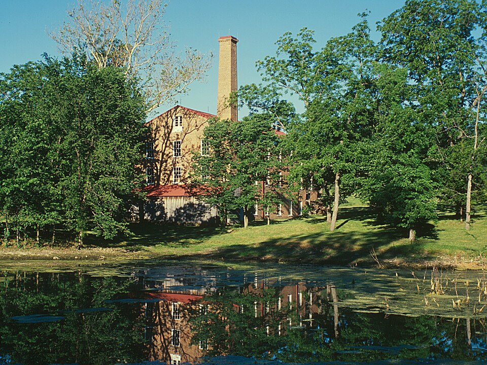
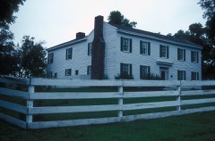
Photograph of Watkins Woolen Mill State Park and State Historic Site
Photograph by Watkins_Mill,_County_Highway_MM,_Lawson_vicinity_(Clay_County,_Missouri).jpg : Jet Lowe, Photographer derivative work: K, Public domain. Via Wikimedia Commons.

Watkins Mill

A National Historic Landmark. Built in 1964. Listed on the National Register of Historic Places in 1966.

From the record

“Watkins Mill is a preserved woolen mill dating to the mid-19th century, located near Lawson, Missouri, United States. The mill is protected as Watkins Woolen Mill State Historic Site, which preserve its machinery and business records in addition to the building itself.”

Wikipedia article Watkins Woolen Mill State Park and State Historic Site, CC BY-SA 4.0.

One of 39 National Register listings published here for Clay County · listed in 1966 · category: District · built in 1964 · a National Historic Landmark.

Sources: the Wikipedia article · the case file at the National Archives · the National Register database, National Park Service
The listing

  • Address. 6 mi. NW of Excelsior, Excelsior, 64062
  • When was it listed? November 1966
  • Category. district
  • Township. Washington township
  • When was it built? 1964
  • National Register reference number. 66000416 - the number the National Park Service assigned this property when it was listed, and the key its nomination file is catalogued under at the National Archives.

What happened here

An account from the chapter on Washington township. The inset identifies its exact source book and publication year.

From History of Clay County, Missouri, published 1920 - Washington Township

Chapter Xxii The Mormons

MORMON INFLUX TO JACKSON COUNTY IN 1832 - TROUBLE IN JACKSON COUNTYTOOK REFUGE IN CLAY AND OTHER COUNTIES- HOSTILITIES AGAINST MORMONS - MORMONS ARMED - FORCES CONCENTRATED AT FAR WEST - STATE MILITIA CALLED OUT - GENERAL DONIPHAN IN COMMAND^ - MORMONS SURRENDER - JOE SMITH .-YND OTHER LEADERS INDICTED - IN JAIL AT LIBERTY - LEADERS SAVED BY' DONIPHAN - GOVERNOR BOGGS MURDERED - MORMONS REMAIN AWAY FROM STATE FOR FIFTY' YEARS - AT INDEPENDENCE.

Read the rest of this passage

The ground it stands on

43,568 words

The chapter on Washington Township in History of Clay County, Missouri, published 1920 names Excelsior. This is what it says, exactly as the scans read.

Although the population of Clay County has not materially increased during the last two decades, yet the lines of manufactures and various industries show a very decided increase within the last five years, which inevitably must in the near future very greatly increase the population of the county. Thus far the increase in population has been in North Kansas City, and Excelsior Springs. Probably no place in the state has more manufacturing plants in course of erection, and to be erected in

Passage source: History of Clay County, Missouri, published 1920.

The principal towns or cities in Fishing River townships are Excelsior Springs and Missouri City. The oi'igin of the latter place was the establishment at the mouth of Rose's branch, in 1834, at what was known as Williams' Landing, whei-e a ferry was kept by Williams. A stock of goods was brought to this place in 1849 by Eli Casey, who opened a store and had as clerks Linneus R. Sublette and Dr. Frank Cooley. Several buildings, residences and store houses were built and the place named Richfield. The high water of the river in 1844, on its receding, left a large sand-bar in front of Richfield, preventing the landing of steamboats and operation of a ferry. A joint stock company composed of Graham L. Hughes. John Keller, John Shouse and others laid out a town just below but mainly on the bluffs overlooking the river, giving it the name of St. Bernard. Below St. Bernard another town was laid out and called Atchison. The first store established on the hill was by Robert G. Gilmer, father of the editor and publisher of the Liberty Tribune and The Liberty Advance. The three towns of St. Bernard, Richfield and Atchison were incorporated by the Legislature as one and given the name of Missouri City, March 14, 1859.

Passage source: History of Clay County, Missouri, published 1920.

Machine-read from a century-old scan, so expect the errors a machine makes: misspelled names, dropped words, stray characters.

Read the whole chapter on Washington Township - 43,568 words on its settlement, mills, schools and churches.

Fires near this property

32 since 1992

Regional context, not property-specific evidence. The federal wildfire occurrence database lists 32 fires within 5 miles of Watkins Mill between 1992 and 2018, burning about 76 acres in total. 1 started naturally. 2 were recorded as arson. Distance is straight-line from the map coordinates, so a fire counted here may appear on a neighbouring settlement's page as well.

Reported cause Fires
Missing data/not specified/undetermined15
Debris and open burning9
Smoking3
Arson/incendiarism2
Natural1
Recreation and ceremony1
Equipment and vehicle use1

The most recent of them, most recent first, with the day each was reported and the service that recorded it.

DateCause SizeReported by Name on the report
3 September 2007Debris and open burningunder an acreMissouri State Fire Marshal's Officenot named
8 August 2018Missing data/not specified/undeterminedunder an acreMissouri Department of Conservation177901-08922-08082018-1512
9 July 2018Debris and open burning7.1 acresMissouri Department of Conservation177358-08922-07092018-1629
7 July 2006Missing data/not specified/undeterminedunder an acreMissouri State Fire Marshal's Officenot named
4 July 2006Missing data/not specified/undeterminedunder an acreMissouri State Fire Marshal's Officenot named
25 July 2011Missing data/not specified/undetermined5.0 acresMissouri Department of Conservationnot named
16 July 2004Naturalunder an acreMissouri State Fire Marshal's Officenot named
23 June 2011Missing data/not specified/undetermined1.0 acresMissouri Department of Conservationnot named

Every fire recorded in Clay County

Mines and quarries near this property

10 of 15 shown

Regional context, not property-specific evidence. The federal mineral resources record lists 15 workings within 5 miles of Watkins Mill: 14 past producers, 1 producer. 1 still produces. What was taken out: Stone, Crushed/Broken. Distance is straight-line from the map coordinates, so a quarry counted here may appear on a neighbouring settlement's page as well.

Where SiteCommodity StatusRecorded
Clay County Mine and MillStone, Crushed/BrokenProducer
Doc Gould MineStone, Crushed/BrokenPast Producer
Everett Q #28-50Stone, Crushed/BrokenPast Producer
Hedges QuarryStone, Crushed/BrokenPast Producer
Kelly QuarryStone, Crushed/BrokenPast Producer
Lawson QuarryStone, Crushed/BrokenPast Producer
Rice QuarryStone, Crushed/BrokenPast Producer
UnkStone, Crushed/BrokenPast Producer
UnknownStone, Crushed/BrokenPast Producer

Every working recorded in Clay County

Map coverage status

No historic map-sheet match is published for this property yet. That does not mean no map exists. This record needs a coordinate-quality review before it can be joined to a sheet boundary. Browse the county's mapped places while that work is pending.

Listed places nearby

6 within 8 miles

Other National Register properties close enough to walk or drive between, ordered by distance from this one. Both positions come from the same geocoding pass that matched these properties to their map sheets.

Sources for this property

National Archives recordThe nomination case file for reference 66000416 in Record Group 79.
Wikipedia articleCommunity-written account of this property, licensed CC BY-SA.
Clay CountyAll 39 listed properties in this county.

Provenance

  • Listing record. National Park Service National Register of Historic Places, listed-properties dataset, current to 2026-05-22.
  • Map join. Address geocoded through the United States Census geocoder, then tested against the published boundary of every sheet in the USGS Historical Topographic Map Collection.
  • How this page is made. Listing fields come from federal records; map-sheet coverage is a labelled coordinate-to-boundary calculation, not a source-field claim.
  • Wildfire. Short, Karen C. 2022. Spatial wildfire occurrence data for the United States, 1992-2020 [FPA_FOD_20221014]. 6th Edition. Fort Collins, CO: Forest Service Research Data Archive. https://doi.org/10.2737/RDS-2013-0009.6 Collected with United States Government funding and usable without additional permissions or fees.
  • Mines and quarries. USGS Mineral Resources Data System (MRDS) https://mrdata.usgs.gov/mrds/ A work of the United States government, no copyright under 17 U.S.C. 105.