 Block
From the record
One of 39 National Register listings published here for Clay County · listed in 1978 · category: Site.
Sources: the case file at the National Archives · the National Register database, National Park Service
Listed on the National Register of Historic Places in 1978.
One of 39 National Register listings published here for Clay County · listed in 1978 · category: Site.
Sources: the case file at the National Archives · the National Register database, National Park Service
An account from the chapter on Washington township. The inset identifies its exact source book and publication year.
MORMON INFLUX TO JACKSON COUNTY IN 1832 - TROUBLE IN JACKSON COUNTYTOOK REFUGE IN CLAY AND OTHER COUNTIES- HOSTILITIES AGAINST MORMONS - MORMONS ARMED - FORCES CONCENTRATED AT FAR WEST - STATE MILITIA CALLED OUT - GENERAL DONIPHAN IN COMMAND^ - MORMONS SURRENDER - JOE SMITH .-YND OTHER LEADERS INDICTED - IN JAIL AT LIBERTY - LEADERS SAVED BY' DONIPHAN - GOVERNOR BOGGS MURDERED - MORMONS REMAIN AWAY FROM STATE FOR FIFTY' YEARS - AT INDEPENDENCE.
The chapter on Washington Township in History of Clay County, Missouri, published 1920 names Kearney. This is what it says, exactly as the scans read.
Again it was deemed advisable to limit the area of the county, and on January 2, 1833, the reduction was made to its present limits, being bounded on the north by Clinton on the east by Ray, on the south by Jackson, with the Missouri River intei"vening - and on the west by Platte. The county comprises 254,423 acres. The county was divided into only two townships - Gallatin and Fishing River; the county seat being in Gallatin until May 2, 1825, when Liberty Township was created. Platte Township was createti June 4, 1827; Washington Township, August 9, 1830, and Kearney Township was created September 3, 1872. That pai-t of the county north of its present limits in 1831, extending to the Iowa line was called Lafayette Township, and was very sparsely settled, and on the west of the limits of the county "attached for civil and military purposes," was the Platte country, or rather the greater part of what constitutes now Platte County, was in 1837, divided into Pettie, CaiToll, Far West and Preston Townships. /
Passage source: History of Clay County, Missouri, published 1920.
The annexation of Texas was the alleged cause of the declaration of war by Mexico against the United States in April, 1846, and a counter declaration by Congress was made, that "a state of war exists between the United States and Mexico." There was a strip of disputed territory lying between the Nueces and Rio Grande rivers, in Texas; the United States troops occupied this territory, when the Mexicans crossed the Rio Grande, with a large army, under command of two able generals, Ampudia and Arista. General Taylor had defeated these troops in their attack on the American forces at Palo Alto on the 8th of May, and at Resaca de la Palma, the day following, and these defeats were accomplished with great slaughter of Mexicans. The United States Congi'ess, in April, 1846, had passed an act authorizing the President to call into the war with Mexico 50,000 troops. The general commanding the American forces determined to attack Mexico at three different places; but changed his plans so that Major-General Scott, with a well appointed force, was sent to Vera Cruz; General Wood was ordered to effect a junction with General Taylor at Saltillo, and Gen. Kearney was ordered to divide his troops into three separate commands; the first to lead in person to the shores of the Pacific. A body of troops of about 1,000 Mis- souri volunteers, under the command of Col. A. W. Doniphan, was ordered to make an invasion of the State of Chihuahua, with the expectation of joining General Wood at the capital ; while the greater number of soldiers were to be left as a garrison at Santa Fe, under the command of Gen. Sterling Price. The original plan of operations against Mexico was as follows: A southern wing of the army or the "Army of Occupation," commanded by Major-General Taylor, was to strike directly into the heart of Mexico ; a column under Brigadier-General Wood, or the "Anny of the Center," to operate against the City of Chihuahua, and a command under Colonel Kearny, afterwards general, known as the "Army of the West," to march upon the city of Santa Fe.
Passage source: History of Clay County, Missouri, published 1920.
Machine-read from a century-old scan, so expect the errors a machine makes: misspelled names, dropped words, stray characters.
Read the whole chapter on Washington Township - 43,568 words on its settlement, mills, schools and churches.
Regional context, not property-specific evidence. The federal wildfire occurrence database lists 58 fires within 5 miles of James Brothers' House and Farm (Boundary Increase) between 1992 and 2018, burning about 135 acres in total. 1 started naturally. 5 were recorded as arson. Distance is straight-line from the map coordinates, so a fire counted here may appear on a neighbouring settlement's page as well.
| Reported cause | Fires |
|---|---|
| Missing data/not specified/undetermined | 29 |
| Debris and open burning | 13 |
| Recreation and ceremony | 8 |
| Arson/incendiarism | 5 |
| Smoking | 2 |
| Natural | 1 |
The most recent of them, most recent first, with the day each was reported and the service that recorded it.
| Date | Cause | Size | Reported by | Name on the report |
|---|---|---|---|---|
| 8 September 2004 | Missing data/not specified/undetermined | under an acre | Missouri State Fire Marshal's Office | not named |
| 3 September 2007 | Debris and open burning | under an acre | Missouri State Fire Marshal's Office | not named |
| 10 September 2004 | Missing data/not specified/undetermined | under an acre | Missouri State Fire Marshal's Office | not named |
| 1 September 2007 | Recreation and ceremony | 6.0 acres | Missouri State Fire Marshal's Office | not named |
| 8 August 2018 | Missing data/not specified/undetermined | under an acre | Missouri Department of Conservation | 177901-08922-08082018-1512 |
| 9 July 2018 | Debris and open burning | 7.1 acres | Missouri Department of Conservation | 177358-08922-07092018-1629 |
| 8 July 2006 | Missing data/not specified/undetermined | under an acre | Missouri State Fire Marshal's Office | not named |
| 7 July 2006 | Missing data/not specified/undetermined | under an acre | Missouri State Fire Marshal's Office | not named |
Regional context, not property-specific evidence. The federal mineral resources record lists 16 workings within 5 miles of James Brothers' House and Farm (Boundary Increase): 14 past producers, 2 producers. 2 still produce. What was taken out: Stone, Crushed/Broken. Distance is straight-line from the map coordinates, so a quarry counted here may appear on a neighbouring settlement's page as well.
| Where | Site | Commodity | Status | Recorded |
|---|---|---|---|---|
| Clay County Mine and Mill | Stone, Crushed/Broken | Producer | ||
| Doc Gould Mine | Stone, Crushed/Broken | Past Producer | ||
| Everett Q #28-50 | Stone, Crushed/Broken | Past Producer | ||
| Everett Quarries #5 | Stone, Crushed/Broken | Producer | ||
| Hedges Quarry | Stone, Crushed/Broken | Past Producer | ||
| Kearney Quarry | Stone, Crushed/Broken | Past Producer | ||
| Kelly Quarry | Stone, Crushed/Broken | Past Producer | ||
| Matthews Quarry | Stone, Crushed/Broken | Past Producer | ||
| Unknown | Stone, Crushed/Broken | Past Producer | ||
| Unknown | Stone, Crushed/Broken | Past Producer |
Regional context, not property-specific evidence. The National Weather Service names Kearney, the town this property stands in, in 78 storm reports between 1993 and 2026: 43 hail, 27 thunderstorm wind, 6 flash flood, 1 tornado. The reports record 1 injury. Each account below is quoted exactly as the forecast office filed it, from the NOAA Storm Events Database, and each date opens the federal record of that event.
| When | Event | Place named | Harm | What the report says |
|---|---|---|---|---|
| June 1994 | Thunderstorm Wind | Kearney | 1 hurt, $5,000 | Power lines and large trees were knocked down. A motorists traveling through the storm was badly bruised by wind blown hail after trying to seek shelter in a nearby ditch. The size of the hail was unknown. |
| August 2000 | Thunderstorm Wind | Kearney | $50,000 | Several large trees were downed in Kearney. Property damage resulted from some of the trees landing on houses. |
| September 2001 | Thunderstorm Wind | Kearney | $2,000 | Several large trees down and gas station signs blown down. |
| April 2026 | Hail | Kearney | - | Quarter sized hail reported in Kearney. |
| May 2025 | Hail | Kearney | - | Tennis ball sized hail near Kearney. |
| May 2025 | Hail | Kearney | - | Golf ball sized hail reported north of Kearney. |
| May 2025 | Hail | Kearney | - | Two inch hail reported in Kearney. |
| May 2025 | Hail | Kearney | - | Half dollar sized hail reported on the south side of Kearney. |
| May 2025 | Hail | Kearney | - | Half dollar sized hail was reported east of Kearney. |
| May 2025 | Thunderstorm Wind | Kearney | - | Multiple social media reports of trees and limbs down in Kearney. |
| March 2025 | Thunderstorm Wind | Kearney | - | Light pole snapped. |
| July 2025 | Thunderstorm Wind | Kearney | - | Report of tree limbs down at Route 92 and Jesse James Farm Road. |
| July 2025 | Thunderstorm Wind | Kearney | - | Carport and vehicle damaged and multiple trees downed at a residence northeast of Kearney. |
| July 2025 | Thunderstorm Wind | Kearney | - | Social media report of limbs down east of Kearney. |
| April 2023 | Hail | Kearney | - | Quarter sized hail was reported in Kearney. |
| June 2023 | Hail | Kearney | - | Quarter sized hail was reported on the south side of Kearney. |
| June 2023 | Hail | Kearney | - | Two inch hail was reported in central Kearney. |
| June 2023 | Hail | Kearney | - | Quarter sized hail was reported on the northwest side of Kearney. |
| March 2022 | Hail | Kearney | - | This report came in via social media. |
| June 2022 | Thunderstorm Wind | Kearney | - | Public reported 60 mph wind via social media. |
| June 2021 | Thunderstorm Wind | Kearney | - | Trained spotter reported 60 mph wind near Kearney. |
| July 2020 | Thunderstorm Wind | Kearney | - | A large tree branch fell due to strong winds. |
| April 2019 | Hail | Kearney | - | This report was received via social media. |
| August 2017 | Flood | Kearney | - | Water was over several roads in Kearney. |
| June 2016 | Thunderstorm Wind | Kearney | - | Several tree branches ranging from 3 to 4 inches were down across the entire area. A large tree was down near Nebo Hills Road and 112th Road. |
| June 2016 | Hail | Kearney | - | This report was received via social media. |
| August 2016 | Flash Flood | Kearney | - | Flash flooding was reported at the intersection of Interstate 35 and Highway 92 near Kearney. |
| May 2015 | Flash Flood | Kearney | - | A water rescue was performed at 172nd St and Bishop Rd. |
| June 2015 | Flash Flood | Kearney | - | Several areas around Kearney received flash flooding as a result of heavy rain. The parking lot to the Pilot Truck Stop was flooded. Vehicles had water up the doors. West of Kearney, there was water flowing over the road at the intersection of Highway 92 and Francis Road. Northwest of Kearney water was flowing over 162nd Road and Nation Road. |
| May 2011 | Tornado (EF0) | Kearney | - | At 1145CST a brief EF0 tornado touchdown, was observed around 1 mile west northwest of Kearney. The tornado touched down and then right back up. No damage was observed. |
| June 2001 | Flash Flood | Kearney | - | 5 to 6 inches of water reported over roadway northeast of Kearney. |
| June 2001 | Flash Flood | Kearney | - | Water reported over roads from heavy rain. |
| June 2001 | Flash Flood | Kearney | - | 92 highway east of Kearney still closed due to flooding from Clear Creek. |
| June 1998 | Thunderstorm Wind | Kearney | - | A storm spotter reported 70 MPH winds along I-29 a mile southwest of Kearney. |
| May 1997 | Hail | Kearney | - | A storm spotter reported one inch diameter hail in Kearney along I-35. |
| May 1997 | Thunderstorm Wind | Kearney | - | A spotter reported a 60 MPH wind gust along I-35 in Kearney during a severe thunderstorm. |
| April 1995 | Hail | Kearney | - | Severe thunderstorms dumped hail from golf ball- to softball-size on parts of northern Kansas City and Gladstone. The storms then moved northeast to Kearney and Holt. Many homes received roof damage and at least four car dealerships received major damage to inventory. Baseball-size hail at the Metro North Mall smashed car windshields and broke windows. |
| April 1993 | Hail | Kearney | - | A cooperative observer reported hail up to nickel-size fell for a duration of 2 minutes. |
| September 2019 | Hail | Kearney | - | no account filed |
| May 2015 | Hail | Kearney | - | no account filed |
| June 2015 | Hail | Kearney | - | no account filed |
| May 2014 | Hail | Kearney | - | no account filed |
| April 2011 | Hail | Kearney | - | no account filed |
| April 2011 | Hail | Kearney | - | no account filed |
| April 2011 | Hail | Kearney | - | no account filed |
| April 2011 | Hail | Kearney | - | no account filed |
| April 2010 | Hail | Kearney | - | no account filed |
| April 2010 | Hail | Kearney | - | no account filed |
| April 2010 | Hail | Kearney | - | no account filed |
| May 2008 | Thunderstorm Wind | Kearney | - | no account filed |
| June 2008 | Hail | Kearney | - | no account filed |
| June 2008 | Hail | Kearney | - | no account filed |
| April 2006 | Hail | Kearney | - | no account filed |
| March 2006 | Hail | Kearney | - | no account filed |
| March 2006 | Hail | Kearney | - | no account filed |
| March 2005 | Hail | Kearney | - | no account filed |
| June 2005 | Thunderstorm Wind | Kearney | - | no account filed |
| June 2004 | Thunderstorm Wind | Kearney | - | no account filed |
| June 2004 | Thunderstorm Wind | Kearney | - | no account filed |
| May 2003 | Hail | Kearney | - | no account filed |
No historic map-sheet match is published for this property yet. That does not mean no map exists. This record needs a coordinate-quality review before it can be joined to a sheet boundary. Browse the county's mapped places while that work is pending.
Other National Register properties close enough to walk or drive between, ordered by distance from this one. Both positions come from the same geocoding pass that matched these properties to their map sheets.
| Photograph | Property | Distance | Listed |
|---|---|---|---|
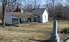 | James Brothers' House and Farm | 0.1 miles | 1972 |
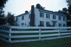 | Claybrook House | 0.9 miles | 1981 |
 | Watkins Mill | 3.3 miles | 1966 |
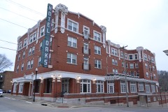 | Excelsior Springs Hall of Waters Commercial West Historic District | 5.6 miles | 1999 |
 | Wyman School | 5.9 miles | 2008 |
 | First Methodist Church | 6.1 miles | 2009 |
| National Archives record | The nomination case file for reference 78003417 in Record Group 79. |
| Clay County | All 39 listed properties in this county. |