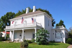
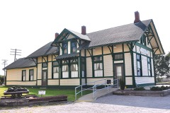
Listed on the National Register of Historic Places in 1981.
From the record
“The Confederate Memorial State Historic Site is a state-owned property occupying approximately 135 acres (55 ha) in northern Higginsville, Missouri, United States. From 1891 to 1950, the site was used as an old soldiers' home for veterans of the Confederate States Army after the American Civil War.”
Wikipedia article Confederate Memorial State Historic Site, CC BY-SA 4.0.
One of 32 National Register listings published here for Lafayette County · listed in 1981 · category: Building.
National Register reference number.81000335- the number the National Park Service assigned this property when it was listed, and the key its nomination file is catalogued under at the National Archives.
Mr. Corder is a native of Rappahannock county, Va.,. born March 5, 1828. His parents moved to Lafayette county in the spring of 1839. Mr. C. has since been a resident of this county, obtaining his education principally in Lexington, Mo. Has always lived upon and operated the farm which his father entered in 1839. In 1861, he enlisted in the Missouri State Guards, under Shelby. He served six months in the M. S. G. and then enlisted in the regular service, joining company C, Col. Gordon's regiment. Was engaged at the battles of Lexington, Pea Ridge, and quite a number of others of less note. Was honorably discharged at Shreveport, in June, 1865. He went through the service without receiving a scratch, although having several bullet holes in his coat, and also having several horses shot under him. In 1853, he married Miss Elizabeth Wall, of Henry county, Mo. Six children were born to them, as follows: Wm. M., Nathan, Rovella A., Robertie Lee, Bettie and George. In 1878, Mr. Corder platted and laid out the town of Corder, which the railroad company named in his honor. Is a member of the A. F. and A. M., Higginsville Lodge, No. 364; also a member of the P. of H., Corder Lodge. Is also a memher of the M. E. church, south, of Dover. Postoffice, Corder.
The subject of this sketch is a native of Missouri, and was born in Warren county, April 8, 1860. Was educated at the Central Wesleyan College, at Warrenton. In 1874, he went to Higginsville, and there engaged in the mercantile business with his brother. Was also engaged with M. E. Keller, at Lexington, in the dry goods and clothing business for a time, and afterwards again at Higginsville. He next went to St. Louis and engaged as traveling saleman, for the wholesale grocery firm of S. B. Sale & Co., with whom he remained for one year. He then purchased his brother's interest in a store at Corder, since which time he has been engaged in the mercantile trade at that place. Has a large and well assorted stock and an excellent trade. December 26, 1880, he was married to Miss Rosie M. Grow, of Higginsville, Mo.
Regional context, not property-specific
evidence. The
federal wildfire occurrence database
lists 33 fires within 5 miles of Confederate Chapel, Cemetery and Cottage
between 2014 and 2020, burning about 244 acres in total. None started naturally. None was recorded as arson.
Distance is straight-line from the map coordinates, so a fire counted
here may appear on a neighbouring settlement's page as well.
Reported cause
Fires
Missing data/not specified/undetermined
22
Debris and open burning
9
Equipment and vehicle use
2
The most recent of
them, most recent first, with the day each was reported and the service
that recorded it.
Regional context, not property-specific
evidence. The federal mineral resources record lists
4 workings within 5 miles of Confederate Chapel, Cemetery and Cottage: 4 past producers.
None of them still produces. What was taken out: Stone, Crushed/Broken. Distance is straight-line from the
map coordinates, so a quarry counted here may appear on a neighbouring
settlement's page as well.
Regional context, not property-specific
evidence. The National Weather Service names
Higginsville, the town this property stands in, in 53 storm reports between 1993 and 2020: 27 thunderstorm wind, 22 hail, 3 tornado, 1 flash flood.
No death or injury is recorded in these reports. Each account below is quoted exactly as the forecast office
filed it, from the NOAA Storm Events Database, and each date
opens the federal record of that event.
A severe thunderstorm dropped up to golfball size hail on Bates City, and then went on to develop 2 weak tornadoes. The first tornado touched down south of Bates City at 1820 CST and was crossing Interstate 70 3 miles west of Odessa at 1831 CST. Only minor tree damage was reported. It then lifted north of Odessa. A second touchdown occurred about 5 miles northwest of Higginsville at 1845 CST. The track took it across State Route 13 5 miles northwest of Higginsville near the Tabo Creek bridge at 1900 CST. At 1905 CST, the tornado crossed Route 213 3 miles southwest of Dover, and then lifted 1 mile southwest of Dover at 1906 CST. A house along state Route 13, 6 miles southeast of the junction with Route E, had shingles removed from the roof as the funnel apparently lifted as it passed overhead. Eyewitnesses reported that the tornado bounced up and down as it continued on a path about 4.5 miles to the east-northeast. The damage path varied from about 30 to 40 yards wide, with most of the path over cultivated farm fields. Most damage was minimal, but the most significant damage occurred at the Humfeldt farm 2.6 miles south of U.S. Route 24 along state Route 213. A corrugated steel equipment building was destroyed when the south and west walls were blown in, and the roof was partially peeled off. There was only minor damage to the equipment inside. The tornado passed to the south of the house and garage, missing them by 25 feet. Only one shutter was blown off of the upper floor of the house with no other damage. Mud was splattered on all four sides of both the house and garage. The tornado was photographed as it was dissipating, in its rope stage between 1901 and 1906 CST. In addition, tree damage occurred in Corder with the gust front ahead of the parent thunderstorm.
At 1425CST a brief EF0 tornado touchdown, was observed by television helicopter, a little over a half north of Higginsville. The tornado moved about a tenth of a mile to the east, and lifted at 1427CST. Touchdown was in an open field with no damage observed.
At 1207CST a brief EF0 tornado touchdown, was observed 1.9 miles south southwest of Higginsville. The tornado touched down and went right back up. No Damage was observed.
The same supercell storm that produced the tornado southeast of Lexington also produced dime to quarter size hail, which covered the ground in Higginsville.
No historic map-sheet match is published
for this property yet. That does not mean no map exists. This record needs
a coordinate-quality review before it can be joined to a sheet boundary.
Browse the county's mapped places while that work is
pending.
Listed places nearby
6 within 8 miles
Other National Register properties close
enough to walk or drive between, ordered by distance from this one. Both
positions come from the same geocoding pass that matched these properties
to their map sheets.
Listing record. National Park Service National Register of Historic Places, listed-properties dataset, current to 2026-05-22.
Map join. Address geocoded through the United States Census geocoder, then tested against the published boundary of every sheet in the USGS Historical Topographic Map Collection.
How this page is made. Listing fields come from federal records; map-sheet coverage is a labelled coordinate-to-boundary calculation, not a source-field claim.
Wildfire. Short, Karen C. 2022. Spatial wildfire occurrence data for the United States, 1992-2020 [FPA_FOD_20221014]. 6th Edition. Fort Collins, CO: Forest Service Research Data Archive. https://doi.org/10.2737/RDS-2013-0009.6 Collected with United States Government funding and usable without additional permissions or fees.
Mines and quarries. USGS Mineral Resources Data System (MRDS) https://mrdata.usgs.gov/mrds/ A work of the United States government, no copyright under 17 U.S.C. 105.
Storms. NOAA National Centers for Environmental Information, Storm Events Database https://www.ncei.noaa.gov/stormevents/ A work of the United States government, no copyright under 17 U.S.C. 105. Narratives are quoted verbatim from the National Weather Service report and are not edited or summarised.
 Block