 Block
From the record
2 National Register listings published here.
Sources: the National Register database, National Park Service
52 topographic sheets cover 21 settlements here, and 2 properties are on the National Register of Historic Places.
2 National Register listings published here.
Sources: the National Register database, National Park Service
Every property in this county listed on the National Register of Historic Places, with the year it was listed and the federal nomination document.
| Photograph | Property | Type | Listed | Reference |
|---|---|---|---|---|
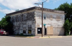 | Gladstone Hotel | building | 1980 | 80004592 |
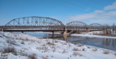 | Lewis and Clark Bridge | structure | 1997 | 97001451 |
Every wildfire the federal occurrence database records inside this county: 82 of them, burning about 9,689 acres. 24 started naturally and 1 was recorded as arson. Each settlement page carries the fires within five miles of it.
| Reported cause | Fires |
|---|---|
| Equipment and vehicle use | 30 |
| Natural | 24 |
| Missing data/not specified/undetermined | 17 |
| Debris and open burning | 4 |
| Fireworks | 2 |
| Power generation/transmission/distribution | 1 |
| Firearms and explosives use | 1 |
| Recreation and ceremony | 1 |
| Arson/incendiarism | 1 |
| Smoking | 1 |
The five largest, by the area the report gives. None of them was recorded as arson.
| Date | Cause | Size | Reported by | Name on the report |
|---|---|---|---|---|
| 24 March 2008 | Debris and open burning | 5,064 acres | Miles City Field Office | EASTER |
| 30 August 2006 | Natural | 1,308 acres | Miles City Field Office | FLYING CREEK |
| 9 August 2020 | Equipment and vehicle use | 422 acres | McCone County | DUCK CREEK |
| 8 September 1998 | Natural | 365 acres | Miles City Field Office | MCCONE |
| 27 August 2020 | Natural | 320 acres | McCone County | FUDGE - MCCONE |
| 23 July 2016 | Equipment and vehicle use | 189 acres | Eastern Land Office | MAXWELL HILL - MCCONE |
| 1 September 2006 | Natural | 156 acres | Miles City Field Office | GIBBS |
| 17 May 2017 | Missing data/not specified/undetermined | 150 acres | Eastern Land Office | STONEY |
Every settlement page carries the fires within five miles of it - see the settlement index below.
The NOAA Storm Events Database holds 479 reports for this county, causing 1 death, 4 injuries and about $5,585,300 in recorded property damage. Each settlement page carries the reports that name it.
| Kind of event | Reports |
|---|---|
| Hail | 237 |
| Thunderstorm Wind | 199 |
| Flash Flood | 16 |
| Tornado | 9 |
| Flood | 8 |
| Heavy Rain | 7 |
| Funnel Cloud | 3 |
The most serious of them, by death, then injury, then recorded damage. The accounts are quoted exactly as the forecast office filed them.
| When | Event | Place named | Harm | What the report says |
|---|---|---|---|---|
| July 1983 | Tornado (F1) | not stated | 1 killed, 1 hurt, $250,000 | no account filed |
| July 1996 | Hail | Circle | 2 hurt, $30,000 | no account filed |
| August 1995 | Hail | Vida | 1 hurt, $25,000 | Three-inch hail damaged car windshields and tore gutters off of homes. Several wheat fields sustained damage. The hail tore the roof off a John Deere combine. One woman was injured when hail struck her in the forehead. |
| July 2001 | Thunderstorm Wind | Circle | $1,600,000 | Damaging downburst winds blew down 25 steel electric towers as well as 25 wooden power poles. It also caused 100 percent crop damage over a 20 mile long area starting from 10 miles north and northwest of Circle, then southeast along Highway 200 to the Dawson County line. The crop damage ranged from 1 to 5 miles wide. Several farms had significant damage to buildings and property. The town of Circle had the grain elevators crushed in, with significant wind damage to other portions of the elevator buildings. Metal sheeting from the grain elevators was found downstream nearly a mile away. Many houses and vehicles had windows broken or shattered, and large trees were uprooted. The Circle Airport had a measured wind gust of 113 mph. |
| June 2021 | Thunderstorm Wind | Cow Creek Dot | $1,200,000 | Several power line poles (both from the local electric cooperative and the Department of Energy, which were replaced in recent years) were snapped at their bases in this area. A nearby home weather station recorded a 79 mph thunderstorm wind gust. |
| May 2020 | Thunderstorm Wind | Brockway | $350,000 | Public reported wind damage just west of Brockway and just south of US Highway 200. Former emergency manager's roof was blown half off, and part of his garage was collapsed. Event time is estimated. House was totaled by insurance. |
| June 2016 | Thunderstorm Wind | Cow Creek Dot | $284,000 | Follow-up information: DOE/WAPA had 14 H-structure power poles snapped or blown over along MT highway 13. These power poles were less than 1 year old. The rural utility company had 50 single-line poles snapped or blown over along MT highway 13. Three to five miles west of that location, another 25 power poles were snapped or blown over. |
| June 2016 | Thunderstorm Wind | Brockway | $280,000 | Significant damage to 30 power transmission poles and 30-40 power distribution poles along Highway 200 between Van Norman and Brockway. A large camper was rolled in the Timber Creek area along Highway 24. |
| July 1995 | Tornado | not stated | $250,000 | A tornado did damage to a farmstead. The tornado lifted a house and then set it back on its foundation. Several outbuildings were destroyed. A grain semi which was parked in front of the yard was overturned. Several ,pick-up trucks parked around the farm were overturned. |
| May 2020 | Thunderstorm Wind | Brockway | $187,000 | Utility company reported more than 100 power poles and 16 distribution towers down along MT-Highway 200. Started about 2 miles west of Brockway, then northeastward toward the town of Circle. |
| June 2005 | Flash Flood | South Portion | $172,000 | Water was running over Horse Creek Road northwest of Circle. There was considerable damage to roads, bridges, and culverts in the southern portion of the county. Three bridges were out due to the heavy rainfall, and one 6 foot culvert collapsed along Duck Creek Road near Watkins. One home was evacuated, and three homes had severe flood damage along County Road 252, and continued to have problems during the month of June with each additional rainfall. |
| July 2000 | Hail | Circle | $150,000 | Baseball sized hail six inches deep fell on the community of Circle breaking windows and destroying area crops. |
| May 2020 | Thunderstorm Wind | Weldon | $100,000 | At the Nelson Creek Recreation Area, law enforcement officials reported three unoccupied camping trailers were rolled and destroyed. |
| May 2020 | Thunderstorm Wind | Weldon | $100,000 | NWS employees conducted a damage survey of a collapsed barn, estimating winds speeds of 85 to 90 mph. |
| July 2015 | Thunderstorm Wind | Vida | $100,000 | A metal pole barn with wooden frame sustained damage from thunderstorm outflow winds, including the roof being blown off, and the north and south walls collapsing. Owner was not present to witness the damage. Event time is estimated from radar imagery. Through discussion and photo analysis of the damage, the peak wind speed is estimated at 95 mph. |
| June 2007 | Hail | Vida | $100,000 | The hail was accompanied by 50 to 60 mph thunderstorm wind gusts. The combination of the hail and wind led to some significant crop damage as well as structural damage to several farms. See entire episode narrative for full details. |
| July 2008 | Thunderstorm Wind | Circle | $45,000 | A small bow echo downed eight power poles along Highway 200 and damaged a few shed roofs. The power was not restored until August 1st. |
| July 1997 | Thunderstorm Wind | Circle | $40,000 | An airplane hanger housing two airplanes was destroyed as its roof was lifted off and the walls caved in. The airplanes inside were significantly damaged. |
| July 2000 | Thunderstorm Wind | Circle | $35,000 | Severe thunderstorm winds took down eight power lines in Circle leaving 100 customers without power. Strong winds also took the top off of on of the local grain bins. |
| June 2010 | Tornado (EF1) | Ft Peck Lake Handar | $30,000 | Landowner reported a tornado that snapped numerous trees and damaged some metal storage sheds across his property. Tornadic winds were estimated from NWS Survey at 100 mph. |
| July 2001 | Hail | Vida | $30,000 | A Montana Department of Transportation truck got caught in large hail along Highway 24, near Rock Creek. The truck had several large hail dents in it, and the windshield was shattered. |
| July 2000 | Flash Flood | Weldon | $30,000 | Heavy rain caused caused a bridge on the Weldon Road to be washed out. |
| July 1999 | Hail | Weldon | $25,000 | A severe thunderstorm dropped softball sized hail near the small community of Weldon. Windows were broken out of homes and pickup trucks. At 11 a.m. the next morning, the hail was still the size of quarters. |
| August 1954 | Tornado (F2) | not stated | $25,000 | no account filed |
| July 2013 | Hail | Brockway | $20,000 | Trained spotter reported hail up to the size of golf balls broke windows, damaged siding, damaged a camper, and destroyed a pea crop. |
| June 2007 | Thunderstorm Wind | Vida | $20,000 | Telephone poles were down on Highway 13 at mile marker 33. Also, 13 power poles were blown down by damaging thunderstorm winds. |
| August 2002 | Flash Flood | Northwest Portion | $20,000 | no account filed |
| June 2007 | Hail | Vida | $10,000 | The hail ranged in size from nickel to quarter and covered the ground. Two windows were blown out on the west side of a home along with some damge to the siding. See entire episode narrative for full details. |
| June 2002 | Thunderstorm Wind | Circle | $10,000 | Wind tipped camper over on Highway 200 5 miles southwest of Circle. |
| August 1995 | Hail | Vida | $10,000 | Grapefruit-size hail damaged shingles and car windshields. Some wheat was destroyed. Some windows were also broken in houses. |
| August 2002 | Hail | Vida | $10,000 | no account filed |
| July 2000 | Thunderstorm Wind | Vida | $10,000 | no account filed |
| July 1998 | Thunderstorm Wind | Brockway | $8,000 | Roof damage done to businesses in Brockway. |
| July 2013 | Hail | Brockway | $5,000 | Trained spotter reported that hail up to the size of baseballs fell for over 10 minutes, breaking windows and stripping most of the leaves from a tree. |
| July 2010 | Thunderstorm Wind | Circle | $5,000 | Awning torn off of a home and flipped up on the roof by severe winds. |
| July 1995 | Thunderstorm Wind | Vandalia | $5,000 | A storm spotter just south of poplar reported an estimated wind gust of 70 mph. |
| July 1995 | Thunderstorm Wind | not stated | $5,000 | no account filed |
| July 1999 | Hail | Vida | $4,000 | no account filed |
| May 1991 | Tornado (F0) | not stated | $2,500 | no account filed |
| May 2010 | Flash Flood | Ft Peck Lake Handar | $1,000 | Spotter reported water over Highway 24 at North Rock Creek turnoff. Adjacent fields were covered with two to three feet of water. |
| August 1998 | Thunderstorm Wind | Vida | $1,000 | A roof was blown off of a small machine shed. |
| July 2008 | Thunderstorm Wind | Vida | $600 | Cottonwood tree limbs were blown off. |
| June 2010 | Hail | Vida | $100 | Clouds were rotating with 50 mph winds accompanying the hail. A window was broken from the storm. |
| July 2008 | Thunderstorm Wind | Brockway | $100 | The wind removed a window screen and blew it across the yard. |
| April 2026 | Thunderstorm Wind | Vida | - | The Vida W Montana Climate Office mesonet site (VDWM8) recorded a 58 mph wind gust. |
| April 2026 | Thunderstorm Wind | Vida | - | The Vida NE Montana Climate Office mesonet site (VDNM8) recorded a 60 mph wind gust. |
| April 2026 | Thunderstorm Wind | Ft Peck Lake Handar | - | The Fort Peck Dam handar site (GGWFP) measured a 59 mph wind gust. |
| April 2026 | Thunderstorm Wind | Weldon | - | The Fort Peck S Montana Climate Office mesonet site (MTM87) recorded a 66 mph wind gust. |
| April 2026 | Thunderstorm Wind | Ft Peck Lake Handar | - | The Fort Peck Lake handar site (GGWFP) recorded a 66 mph wind gust. |
| May 2025 | Thunderstorm Wind | Weldon | - | Report occurred at the Mesonet station MTM87 Fort Peck S. |
| June 2025 | Hail | Circle | - | Hail up to the size of quarters was reported with wind gusts up to 30 mph. |
| June 2025 | Thunderstorm Wind | Ft Peck Lake Handar | - | This was reported by the Handar at the Fort Peck Dam station. |
| July 2025 | Hail | Brockway | - | Trained spotter reported that their vehicle windshield was cracked by hen egg size hail. |
| July 2025 | Hail | Brockway | - | Public reported hen egg size hail. |
| July 2025 | Thunderstorm Wind | Ft Peck Lake Handar | - | A wind gust of 60 mph was measured at the Fort Peck Dam mesonet site (GGWFP). |
| July 2025 | Thunderstorm Wind | Brockway | - | Public reported difficulty controlling their vehicle and estimated wind gusts of 60 mph. |
| July 2025 | Thunderstorm Wind | Vida | - | Trained spotter reported a 63 mph wind gust. |
| July 2025 | Funnel Cloud | Brockway | - | Video of a funnel cloud was recorded by a storm chaser and posted on social media. |
| July 2025 | Hail | Brockway | - | Trained spotter reported their truck window was broken by ping pong ball size hail. |
| August 2025 | Thunderstorm Wind | Ft Peck Lake Handar | - | Public estimated 80 mph wind gusts. |
Named settlements recorded in the Geographic Names Information System, each with the topographic sheets covering it. Villages, hamlets and abandoned places alike. Each is shown with the nearest named watercourse or landform and the survey quadrangle it falls on.
Circle census division · 59214 · On Cotter Creek · Brockway quadrangle
6 sheets, 1954 to 1983
North McCone census division · 59223 · Fort Peck quadrangle
11 sheets, 1914 to 1984
No longer a settlement
Circle census division · 59215 · Near Devils Table Rock · Rodgers Hall quadrangle
8 sheets, 1954 to 1978
No longer a settlement
North McCone census division · 59215 · Hudiburgh Reservoir NW quadrangle
5 sheets, 1954 to 1983
No longer a settlement
Circle census division · 59215 · Hudiburgh Reservoir SE quadrangle
5 sheets, 1954 to 1983
No longer a settlement
North McCone census division · 59223 · Fort Peck quadrangle
11 sheets, 1914 to 1984
No longer a settlement
Circle census division · 59214 · Flowing Well quadrangle
7 sheets, 1954 to 1983
No longer a settlement
North McCone census division · 59201 · On Prairie Elk Creek · Flynn Creek South quadrangle
7 sheets, 1915 to 1972
No longer a settlement
North McCone census division · 59201 · On U P Creek · Macon quadrangle
6 sheets, 1916 to 1972
No longer a settlement
North McCone census division · 59201 · Near Williams Coulee · Sadie Coulee quadrangle
5 sheets, 1954 to 1983
No longer a settlement
North McCone census division · 59201 · On Box Elder Creek · Flynn Creek South quadrangle
7 sheets, 1915 to 1972
North McCone census division · 59274 · Vida quadrangle
5 sheets, 1954 to 1983
No longer a settlement
Circle census division · 59215 · On Spring Creek · Buffalo Creek quadrangle
5 sheets, 1954 to 1983
No longer a settlement
North McCone census division · 59274 · Dailey Spring quadrangle
5 sheets, 1954 to 1983
No longer a settlement
Circle census division · 59214 · Cemetery Coulee quadrangle
7 sheets, 1954 to 1983
No longer a settlement
The vanished settlements of McCone County: the places named above that are no longer on the map.