 Block
From the record
7 National Register listings published here.
Sources: the National Register database, National Park Service
45 topographic sheets cover 20 settlements here, and 7 properties are on the National Register of Historic Places.
7 National Register listings published here.
Sources: the National Register database, National Park Service
Every property in this county listed on the National Register of Historic Places, with the year it was listed and the federal nomination document.
| Photograph | Property | Type | Listed | Reference |
|---|---|---|---|---|
 | Carroll House Hotel | building | 1994 | 94000221 |
 | Dickey County Courthouse | building | 1980 | 80004283 |
 | Ellendale Opera House Block | building | 1992 | 92000354 |
 | Klein and Sutmar Block | building | 1987 | 87001792 |
| Walter T. Noonan House | building | 1987 | 87001791 | |
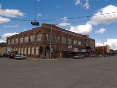 | Oakes National Bank Block | building | 1987 | 87001790 |
 | US Post Office-Oakes | building | 1989 | 89001753 |
Every wildfire the federal occurrence database records inside this county: 51 of them, burning about 943 acres. 3 started naturally and none was recorded as arson. Each settlement page carries the fires within five miles of it.
| Reported cause | Fires |
|---|---|
| Debris and open burning | 19 |
| Equipment and vehicle use | 12 |
| Missing data/not specified/undetermined | 9 |
| Power generation/transmission/distribution | 5 |
| Natural | 3 |
| Smoking | 1 |
| Fireworks | 1 |
| Recreation and ceremony | 1 |
The five largest, by the area the report gives. None of them was recorded as arson.
| Date | Cause | Size | Reported by | Name on the report |
|---|---|---|---|---|
| 22 April 2008 | Missing data/not specified/undetermined | 360 acres | North Dakota State Forest Service | SHARP PRUITZ |
| 15 April 2008 | Missing data/not specified/undetermined | 300 acres | North Dakota State Forest Service | TIMOTHY WAGNER CRP |
| 11 October 2015 | Debris and open burning | 100 acres | Kulm Wetlands Management District | REINKE WPA |
| 26 August 2017 | Equipment and vehicle use | 21 acres | North Dakota State Forest Service | TANK |
| 13 March 2016 | Missing data/not specified/undetermined | 20 acres | North Dakota State Forest Service | ZETOCHA FIRE |
| 11 July 2017 | Equipment and vehicle use | 20 acres | North Dakota State Forest Service | WOLF |
| 11 April 2003 | Debris and open burning | 16 acres | Kulm Wetlands Management District | KNUTSON |
| 6 April 2017 | Debris and open burning | 15 acres | North Dakota State Forest Service | 242017 |
Every settlement page carries the fires within five miles of it - see the settlement index below.
The NOAA Storm Events Database holds 294 reports for this county, causing no deaths, 2 injuries and about $8,733,280 in recorded property damage. Each settlement page carries the reports that name it.
| Kind of event | Reports |
|---|---|
| Hail | 140 |
| Thunderstorm Wind | 92 |
| Tornado | 35 |
| Funnel Cloud | 10 |
| Flash Flood | 8 |
| Flood | 4 |
| Heavy Rain | 3 |
| Lightning | 2 |
The most serious of them, by death, then injury, then recorded damage. The accounts are quoted exactly as the forecast office filed them.
| When | Event | Place named | Harm | What the report says |
|---|---|---|---|---|
| August 1989 | Thunderstorm Wind | not stated | 1 hurt | no account filed |
| August 1989 | Thunderstorm Wind | not stated | 1 hurt | no account filed |
| July 2011 | Thunderstorm Wind | Merricourt | $1,250,000 | A National Weather Service Storm Survey was conducted across Dickey County. Widespread mature hardwood trees were snapped or uprooted along a 45 mile long and 4 mile wide damage swath, along with thousands of acres of crop damage due to wind driven hail. Several communities along the damage path also had severe wind damage. Near Merricourt, damage was observed to a home and to several farm vehicles. In Monango, extensive tree damage was observed, including a large hardwood tree with the diameter of 22 inches. A pole barn and two grain bins were destroyed two miles south of Fullerton, along with several large trees snapped or uprooted. Around Oakes, numerous buildings sustained heavy damage, along with the destruction of a 200 foot radio station tower. Damage across Dickey County was extensive. |
| June 2022 | Thunderstorm Wind | Ellendale | $1,000,000 | Extensive damage occurred throughout the city of Ellendale and surrounding areas. In Ellendale, many hardwood trees were snapped and others were uprooted, some falling onto homes. A home had almost all the shingles and much of the sheathing torn off the roof, and the garage door was collapsed inward. Some power poles were broken in town, and several power service lines to homes were torn. South of Ellendale to the South Dakota state line, multiple power poles were snapped. At the Ellendale Cemetery, multiple hardwood and softwood trees were snapped and others were uprooted. In parts of Ellendale, ping pong ball size hail accompanied the storm. |
| July 1999 | Tornado (F2) | Ellendale | $800,000 | One half mile debris from 3 mobile homes. Large trees uprooted. 70kt winds reported with storm. |
| June 2005 | Flash Flood | Merricourt | $750,000 | no account filed |
| July 2018 | Flash Flood | Ellendale Arpt | $500,000 | Rain amounts across the Ellendale area ranged from five to eight inches from slow moving rain showers and low-topped thunderstorms. The bulk of the rain fell in about three hours with the rain event lasting about six hours. This led to runoff that flooded basements with up to four feet of water and caused sanitary sewer systems to back up. One basement wall collapsed. A total of 24 homes were affected along with two churches and one apartment complex. |
| July 2011 | Flood | Forbes | $500,000 | Persistent thunderstorms with heavy rain over a long period of time brought widespread flooding to many county and township roads across Dickey County. |
| June 1998 | Hail | Oakes | $500,000 | Report from insurance adjuster. |
| August 1993 | Hail | Forbes | $500,000 | The hail occurred with 4.15 inches of rain in 70 minutes. The hail damaged a 30-square mile area in southern Dickey County. |
| June 2007 | Thunderstorm Wind | Ellendale | $450,000 | NWS storm survey completed on Monday, June 18, and confirmed the findings of emergency management officials, that very high thunderstorm winds and not a tornado caused the damage in Dickey County. Over most of the wind damage area the damage was consistent with wind speeds of 70 mph. However, in an area inside the city limits of Ellendale, from the elevator toward the northeast, damage was consistent with wind speeds of 85 mph. Damage was mainly to trees throughout the area and to grain bins in the immediate Ellendale area, along with a few power lines and a cell phone communications tower. Part of the elevator was completely toppled onto the street below. Note that some of the large diameter trees uprooted in Ellendale would have been consistent with 90 or 95 mph winds, and that speeds were reduced due to saturated soils. The area had received 16.7 inches of rain since March 1. There were no deaths or injuries. |
| April 2009 | Flood | Merricourt | $250,000 | Rapid snowmelt created overland flooding and flooding along the James River resulting in damage to numerous county and local roads and two homes. |
| July 2007 | Thunderstorm Wind | Merricourt | $250,000 | Combined severe thunderstorm winds and hail as large as half dollars (1.25 inch diameter) resulted in very significant crop damage through Dickey County. Damage extended from near the Lamoure County line northeast of Merricourt, through Dickey County, into Brown County, South Dakota. Dickey County Emergency Management reported an average 4 mile wide hail swath in the vicinity of Highway 281 with nearly 100 percent crop damage is some areas. At 1100 PM CDT an estimated 95 mph wind 1 mile west of Monango damaged many outbuildings on a hog farm. Some buildings were significantly damaged at the farm. This same storm crossed into Brown County, South Dakota, and did extensive damage there. See the StormData entry from the Aberdeen National Weather Service office. |
| June 2022 | Hail | Forbes | $200,000 | Siding and roofs of homes were damaged, and multiple vehicles were dented. |
| June 2021 | Thunderstorm Wind | Oakes | $200,000 | Several large tree branches around Oakes were snapped. Garaged doors were blown in, and a home TV tower was bent over. |
| June 2020 | Thunderstorm Wind | Ellendale | $150,000 | A 130 foot by 300 foot pole barn structure sustained substantial damage from straight line winds. Almost all of the roofing structure collapsed, along with portions of the walls. The debris was spread to the north of the structure. |
| July 2018 | Thunderstorm Wind | Oakes Muni Arpt | $150,000 | A center-pivot irrigation system was blown completely over. Large trees were uprooted. |
| September 2017 | Hail | Monango | $125,000 | There was damage to crops and property. |
| May 2007 | Flash Flood | Ellendale | $100,000 | Reported rainfall ammounts up to 5 inches caused street flooding, basement flooding, and water standing in fields. |
| March 2009 | Flood | Merricourt | $99,000 | Overland flooding damaged state, county and township roads. The James River spilled and flooded two homes. Flooding continued into April. |
| July 2008 | Thunderstorm Wind | Ellendale | $85,000 | Severe thunderstorm wind gusts overturned several grain bins and destroyed them. Tree limbs were broken and crops were damaged. |
| July 2011 | Tornado (EF1) | Merricourt | $75,000 | A National Weather Service storm survey confirmed that an EF1 tornado on the Enhanced Fujita Scale briefly touched down five miles northwest of Merricourt. There was an eye witness to the tornado. A pole barn was damaged along with numerous trees snapped. The damage corresponded to low end EF1 on the Enhanced Fujita Scale. From that it was determined that wind speeds were on the order of 90 miles per hour. |
| August 2016 | Flash Flood | Forbes | $60,000 | Dickey County Highway 2 was flooded in multiple locations between the communities of Forbes and Merricourt. Very heavy rain fell on locations that received up to three inches of rain the previous night. Multiple additional township roads also became flooded throughout Dickey County and some were washed out in places. |
| April 2023 | Flood | Merricourt | $50,000 | Flooding from snow melt runoff caused significant damages to county infrastructure. |
| June 2020 | Thunderstorm Wind | Ellendale Arpt | $50,000 | Multiple trees and at least one power pole blew down in the city of Ellendale. |
| July 2016 | Thunderstorm Wind | Forbes | $50,000 | The public reported thunderstorm wind gusts of 60 mph combined with nickel sized hail. Damage occurred to shingles on roofs and to vehicles. |
| July 2011 | Thunderstorm Wind | Ludden | $50,000 | Strong thunderstorm winds resulted in numerous trees and branches blown down around Ludden. |
| August 2009 | Thunderstorm Wind | Ellendale | $50,000 | Numerous tree damage was reported in the city of Ellendale due to the severe thunderstorm winds. |
| June 2015 | Hail | Fullerton | $50,000 | no account filed |
| September 2017 | Hail | Merricourt | $40,000 | Windows and vehicles were damaged. |
| June 2013 | Thunderstorm Wind | Glover | $40,000 | Strong thunderstorm winds resulted in small trees uprooted, a sixty-four foot antenna tower broken off, and damage to an outbuilding. |
| July 2011 | Thunderstorm Wind | Fullerton | $25,000 | Strong thunderstorm winds blew numerous tree branches down. |
| June 1992 | Tornado (F1) | not stated | $25,000 | no account filed |
| June 1967 | Tornado (F1) | not stated | $25,000 | no account filed |
| July 1966 | Tornado (F2) | not stated | $25,000 | no account filed |
| May 1965 | Tornado (F0) | not stated | $25,000 | no account filed |
| June 1957 | Tornado (F2) | not stated | $25,000 | no account filed |
| August 2019 | Thunderstorm Wind | Clement | $20,000 | Multiple trees were snapped, some that were large. Crops in the area were flattened or severely damaged. Radar analysis indicated that this may have been due to a wet microburst. |
| June 2013 | Flash Flood | Ellendale | $20,000 | Fast moving water damaged roads and shoulders. Two County roads were closed. Rain reports ranged from 2.72 inches to nearly five inches. |
| August 2021 | Thunderstorm Wind | Ellendale | $15,000 | Some limbs were blown off a few trees, and an old tree blew over and damaged a power pole. |
| July 2018 | Thunderstorm Wind | Oakes Muni Arpt | $15,000 | Two power poles were snapped, and crops were shredded and destroyed. |
| July 2011 | Thunderstorm Wind | Merricourt | $15,000 | Strong thunderstorm winds blew over a grain bin. |
| July 2011 | Thunderstorm Wind | Ellendale | $15,000 | Strong thunderstorm winds resulted in roof damage. |
| July 2011 | Thunderstorm Wind | Merricourt | $15,000 | Evergreen trees were snapped in the city of Merricourt. |
| March 2009 | Flash Flood | Oakes | $15,000 | Minor damage occurred to county roads due to the flash flooding. Action by county crews kept flash flood waters away from a few homes that were threatened. |
| May 2008 | Tornado (EF0) | Guelph | $10,000 | The Dickey County Emergency Manager conducted a storm survey in the area and found evidence of a weak tornado. Tree branches were broken in parts of tree rows. No other structures were impacted. This was the first of three tornadoes in Dickey County this evening. An EF scale rating of middle EF0 was assigned with estimated wind speeds around 75 mph. |
| May 2008 | Tornado (EF0) | Oakes | $10,000 | The Dickey County Emergency Manager conducted a storm damage survey. This tornado remained in open areas, uprooting smaller trees and breaking branches. This was the third of three tornadoes in Dickey County this evening. An EF scale rating of middle EF0 was assigned with estimated wind speeds around 75 mph. |
| May 2008 | Tornado (EF0) | Guelph | $10,000 | A Dickey County Deputy Sheriff originally reported this tornado and indicated that it was visible only as debris rotating on the ground with little if any visible condensation funnel. The Dickey County Emergency Manager later conducted a storm damage survey. There was minor damage to one side of a farm house near the tornado starting point about 4 miles northwest of Guelph. No other damage was observed as the tornado then remained over open areas. This was the second of three tornadoes in Dickey County this evening. An EF scale rating of higher end EF0 was assigned with estimated wind speeds around 80 mph. |
| July 2008 | Thunderstorm Wind | Ellendale | $10,000 | A second wave of severe thunderstorm wind gusts caused damage to trees in the city of Ellendale. |
| June 2014 | Thunderstorm Wind | Oakes | $8,000 | There were multiple reports of wind damage in Oakes. A few trees were blown down and a swing set was blown over. |
| August 2006 | Hail | Fullerton | $5,000 | Broken windows. |
| July 1999 | Hail | Monango | $5,000 | Damage to sheriff vehicle. |
| June 2008 | Thunderstorm Wind | Ellendale | $4,000 | Estimated thunderstorm wind gusts of 75 miles per hour blew down a tree one foot in diameter, and also snapped three inch in diameter branches. |
| July 2020 | Thunderstorm Wind | Forbes | $3,000 | Multiple large cottonwood trees blew over or were snapped. |
| July 2020 | Thunderstorm Wind | Forbes | $3,000 | Two larger diameter trees were blown down. In addition, numerous smaller branches and limbs were also blown down. |
| July 2012 | Thunderstorm Wind | Ellendale | $3,000 | Numerous small tree limbs were blown down by the strong winds. |
| May 1970 | Tornado (F0) | not stated | $2,500 | no account filed |
| August 1960 | Tornado (F2) | not stated | $2,500 | no account filed |
| June 1998 | Hail | Fullerton | $2,000 | Damage to vehicle. |
| September 1997 | Thunderstorm Wind | Fullerton | $1,000 | winds tore heavy steel door off of a grain bin. door has yet to be found |
The Survey's mineral resources record lists 3 workings inside this county. None of them still produces: all are closed or unrecorded. Each settlement page carries the workings within five miles of it.
| Commodity | Workings |
|---|---|
| Sand and Gravel, Construction | 3 |
The least common of them first, because a county's hundredth gravel pit says nothing its first ten did not.
| Where | Site | Commodity | Status | Recorded |
|---|---|---|---|---|
| Dickey County Hwy Dept Pit | Sand and Gravel, Construction | Past Producer | ||
| Redland Pit | Sand and Gravel, Construction | Past Producer | ||
| Wiese Pit | Sand and Gravel, Construction | Past Producer |
Named settlements recorded in the Geographic Names Information System, each with the topographic sheets covering it. Villages, hamlets and abandoned places alike. Each is shown with the nearest named watercourse or landform and the survey quadrangle it falls on.
Hudson township · 58474 · Fullerton SE quadrangle
13 sheets, 1894 to 1986
No longer a settlement
Keystone township · 58436 · On South Fork Maple River · Monango quadrangle
12 sheets, 1894 to 1986
No longer a settlement
Port Emma township · 58474 · Guelph quadrangle
13 sheets, 1894 to 1986
No longer a settlement
The vanished settlements of Dickey County: the places named above that are no longer on the map.