 Block
From the record
6 National Register listings published here, 1 of them a National Historic Landmark.
Sources: the National Register database, National Park Service
26 topographic sheets cover 8 settlements here, and 6 properties are on the National Register of Historic Places.
6 National Register listings published here, 1 of them a National Historic Landmark.
Sources: the National Register database, National Park Service
Every property in this county listed on the National Register of Historic Places, with the year it was listed and the federal nomination document.
| Photograph | Property | Type | Listed | Reference |
|---|---|---|---|---|
 | Beulah School | building | 1997 | 97001200 |
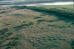 | Big Hidatsa Village Site | site | 1966 | 66000600 |
 | Fort Clark Archeological District | site | 1986 | 86002800 |
| Knife River Bridge near Stanton | structure | 2001 | 01000428 | |
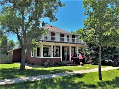 | Fred Krause House | building | 1992 | 92000344 |
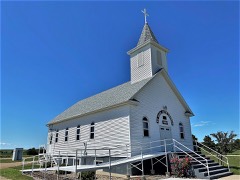 | St. Paul's Lutheran Church | building | 2005 | 05000625 |
Every wildfire the federal occurrence database records inside this county: 116 of them, burning about 4,046 acres. 14 started naturally and 2 were recorded as arson. Each settlement page carries the fires within five miles of it.
| Reported cause | Fires |
|---|---|
| Missing data/not specified/undetermined | 28 |
| Equipment and vehicle use | 24 |
| Debris and open burning | 20 |
| Natural | 14 |
| Fireworks | 8 |
| Recreation and ceremony | 7 |
| Smoking | 4 |
| Power generation/transmission/distribution | 4 |
| Railroad operations and maintenance | 2 |
| Arson/incendiarism | 2 |
| Misuse of fire by a minor | 2 |
| Firearms and explosives use | 1 |
The five largest, by the area the report gives. None of them was recorded as arson.
| Date | Cause | Size | Reported by | Name on the report |
|---|---|---|---|---|
| 12 March 2012 | Missing data/not specified/undetermined | 1,000 acres | North Dakota State Forest Service | SCHNEIDER FIRE |
| 20 February 2012 | Debris and open burning | 610 acres | Knife River Indian Villages National Historic Site | KREIGER WF |
| 3 August 2016 | Equipment and vehicle use | 550 acres | North Dakota State Forest Service | FIELD FIRE |
| 28 September 2012 | Equipment and vehicle use | 500 acres | North Dakota State Forest Service | STEVE OSTER FIRE |
| 15 March 2008 | Missing data/not specified/undetermined | 350 acres | North Dakota State Forest Service | JEFF OLIGER |
| 14 April 2008 | Missing data/not specified/undetermined | 300 acres | Knife River Indian Villages National Historic Site | BUFFALO HILL |
| 14 April 2015 | Equipment and vehicle use | 100 acres | North Dakota State Forest Service | REICH |
| 20 April 1998 | Missing data/not specified/undetermined | 80 acres | Fort Berthold Agency | LUKYMOUND |
Every settlement page carries the fires within five miles of it - see the settlement index below.
The NOAA Storm Events Database holds 318 reports for this county, causing no deaths, 3 injuries and about $9,109,000 in recorded property damage. Each settlement page carries the reports that name it.
| Kind of event | Reports |
|---|---|
| Hail | 148 |
| Thunderstorm Wind | 128 |
| Tornado | 22 |
| Flood | 7 |
| Funnel Cloud | 5 |
| Flash Flood | 4 |
| Heavy Rain | 3 |
| Lightning | 1 |
The most serious of them, by death, then injury, then recorded damage. The accounts are quoted exactly as the forecast office filed them.
| When | Event | Place named | Harm | What the report says |
|---|---|---|---|---|
| July 1976 | Tornado (F1) | not stated | 2 hurt, $25,000 | no account filed |
| June 1956 | Tornado (F3) | not stated | 1 hurt, $250,000 | no account filed |
| August 2014 | Flood | Golden Vly | $2,500,000 | Upwards of nine inches of rain in parts of western Mercer County led to very significant overland flooding. There was also flooding along the Knife River, Spring Creek, and their tributaries. Water was added to the Knife River system not only from rain in Mercer County but rain in Dunn County as well. There was significant damage to roads and crops. Officials estimated damage to at least 90 residences. Damage occurred to storm sewer and sanitary sewer systems. A county emergency declaration was issued. |
| August 2023 | Thunderstorm Wind | Pick City | $1,000,000 | In the Beulah Bay area, two homes had parts of their roofs torn off, large trees were uprooted, manufactured homes were damaged, and multiple campers and boats on trailers were flipped. At Hazen Bay, campers were flipped and trees uprooted. Significant crop damage was also observed throughout this area and surrounding areas, with many fields appearing completely flattened suffering total crop loss. |
| March 2009 | Flood | Golden Vly | $553,000 | Spring Creek and the Knife River flooded due to snow melt and ice jams. The Knife, through Beulah, did significant damage to structures. Overland flooding damaged county and township roads. Fifty five homes were flooded. Flooding continued into April. |
| June 2025 | Thunderstorm Wind | Stanton | $500,000 | Homes were damaged with shingles and siding blown off. |
| June 2011 | Flood | Pick City | $500,000 | See the event episode narrative for details. |
| June 2018 | Thunderstorm Wind | Stanton | $400,000 | An intense microburst occurred at this location with estimated 130 mph winds. Every building on the property was severely damaged or destroyed. The home suffered severe damage with the roof being torn off and the back wall blown out. Four people were inside the home and sought shelter in the basement, uninjured. Large diameter trees were snapped. Crops were also damaged. |
| August 2006 | Hail | Stanton | $350,000 | Damage to vehicles, roofs, and windows. Five Mercer County Sheriff vehicles damaged. |
| June 2018 | Thunderstorm Wind | Stanton | $300,000 | Numerous large tree branches were broken, and several large tree trunks snapped in the city of Stanton. A few garages had a wall blown out or parts of their roofs torn off. |
| August 2006 | Hail | Stanton | $300,000 | Extensive damage to 40 vehicles and several buildings at the Great River Energy Plant. |
| April 2009 | Flood | Golden Vly | $255,000 | A second round of flooding along the Knife River and Spring Creek resulted in additional damage to homes near Beulah and Hazen. State, county, and township roads were also damaged. |
| July 1988 | Tornado (F0) | not stated | $250,000 | no account filed |
| July 1976 | Tornado (F1) | not stated | $250,000 | no account filed |
| August 2023 | Thunderstorm Wind | Hazen | $150,000 | Multiple hopper-style grain bins were blown over, with another bin damage. A wooden structure was also damaged. |
| June 2018 | Thunderstorm Wind | Stanton | $150,000 | A large wooden barn was completely destroyed. |
| June 1999 | Tornado (F1) | Beulah | $150,000 | damage confined to farm stead. |
| July 2016 | Thunderstorm Wind | Hazen | $100,000 | Numerous trees were down in Hazen. |
| July 2016 | Thunderstorm Wind | Hazen | $100,000 | A camper trailer was turned over on its side. House siding was torn off and road signs were flattened. |
| July 2009 | Thunderstorm Wind | Stanton | $75,000 | Severe thunderstorm wind gusts resulted in extensive tree damage in and around Stanton. Several windows were blown out. |
| April 2023 | Flood | Golden Vly | $70,000 | Flooding from snow melt runoff caused significant damages to county infrastructure. |
| July 2010 | Thunderstorm Wind | Beulah | $70,000 | Estimated winds of 60 mph were reported. A light pole at a gas station in Beulah was blown over, along with several trees in the town of Beulah blown down. Blown over trees or branches knocked utility lines to the ground, momentarily disrupting power. |
| July 2014 | Hail | Zap | $60,000 | Strong winds accompanied the large hail. Follow up reports included damage to structures, vehicles, and crops. |
| July 2025 | Thunderstorm Wind | Golden Vly | $50,000 | A roof was torn off a mobile home. |
| June 2021 | Thunderstorm Wind | Golden Vly | $50,000 | A recreational vehicle was tipped over, and a small garage was shifted off its foundation. |
| July 2011 | Thunderstorm Wind | Pick City | $50,000 | The strong winds flipped over campers. |
| August 2010 | Tornado (EF0) | Beulah | $50,000 | A tornado touched down in Mercer County and impacted a farmstead. A large cottonwood tree was uprooted and two grain bins were destroyed. The damage corresponded to a middle EF0 on the Enhanced Fujita Tornado Scale. From that it was determined that wind speeds were around 75 mph. |
| August 1993 | Hail | Beulah | $50,000 | no account filed |
| August 1993 | Thunderstorm Wind | Hebron | $50,000 | no account filed |
| September 2010 | Flash Flood | Golden Vly | $45,000 | Torrential rain resulted in a flash flood around Zap. A thunderstorm rain total of 4.75 inches was reported from six miles northwest of Zap. Two feet of water covered county roads and highway 200. There was also a report of water in the basement of a home. In addition, Spring Creek near Zap rose nearly ten feet in response to the rain. It pushed the creek to almost one foot over flood stage. The creek was quick to receed. |
| August 2006 | Flash Flood | Beulah | $40,000 | Flash flooding between the cities of Beulah and Hazen, along each side of highway 200, and in the city of Beulah. Major roads were not flooded while some county roads were under water and partially washed out. A few streets in Beulah were closed due to high water. |
| June 2018 | Thunderstorm Wind | Pick City | $35,000 | A medium sized wooden outbuilding on a farm was shifted off its foundation, while its front door was torn off and back wall was blown out. |
| July 1997 | Tornado (F0) | Golden Vly | $35,000 | Tornado touched down 2 N of Golden Valley and moved to the north before dissipating. Tornado destroyed a pole barn and an airplane hanger. Strangely the airplane in the hanger only received a few scratches. |
| July 2014 | Hail | Beulah | $30,000 | There was crop, roof, and vehicle damage. |
| July 2008 | Hail | Hazen | $30,000 | A swath of quarter to golf ball size hail fell south to north across the city of Hazen. Some property damage was reported, but there were no specifics. |
| May 1975 | Tornado (F2) | not stated | $25,000 | no account filed |
| August 1969 | Tornado (F1) | not stated | $25,000 | no account filed |
| August 1962 | Tornado (F1) | not stated | $25,000 | no account filed |
| July 2024 | Thunderstorm Wind | Hazen | $20,000 | Tree damage occurred in the city of Hazen. |
| July 2006 | Thunderstorm Wind | Beulah | $20,000 | Roof torn from barn. |
| June 2012 | Hail | Zap | $12,000 | Large hail resulted in minor car and home damage. |
| July 2025 | Thunderstorm Wind | Pick City | $10,000 | A tree uprooted at Lake Shore Estates/Dakota Waters Bay, and many tree branches were blown down at Lake Shore Estates. |
| July 2014 | Thunderstorm Wind | Hazen | $10,000 | Large hail accompanied the strong winds. Trees were snapped and branches broken. |
| July 2014 | Thunderstorm Wind | Golden Vly | $10,000 | Hail and heavy rain accompanied the strong winds. There was minor flooding. |
| August 2011 | Thunderstorm Wind | Beulah | $10,000 | Large hail accompanied the strong winds and damaged property on the farm. |
| July 2009 | Thunderstorm Wind | Beulah | $10,000 | Severe thunderstorm wind gusts resulted in some tree damage in and around Beulah. |
| June 2018 | Flash Flood | Golden Vly | $8,000 | A slow moving thunderstorm produced heavy rain over eastern Dunn County and western Mercer County. Over five inches of rain fell over some locations causing creeks to come out of their banks and overland flooding to develop. Water was running across North Dakota Highway 1806 in Mercer County. Crops were damaged by the water. |
| July 2008 | Thunderstorm Wind | Stanton | $8,000 | Strong thunderstorm winds blew down 12 inch diameter trees. |
| August 2021 | Hail | Beulah | $7,000 | A pickup truck was damaged. |
| June 2008 | Hail | Stanton | $7,000 | Golfball to baseball size hail was reported. Damage was sustained to multiple skylights and shingles at the Knife River Indian Villages National Historic Site. Other damage reports were unavailable. |
| June 2021 | Thunderstorm Wind | Beulah | $5,000 | A chicken coop was destroyed. |
| July 2015 | Thunderstorm Wind | Stanton | $5,000 | A trained spotter reported that large tree branches were broken. |
| July 2013 | Thunderstorm Wind | Stanton | $5,000 | Tree 18 inches in diameter knocked over. |
| July 2005 | Lightning | Hazen | $5,000 | Home struck by lightning. Blew out the TV, VCR, and telephone. Plaster in the bathroom was knocked off the walls. An electircal outlet on the outside of the home had the cover on it blown off and thrown 15 feet. The plug outlet was no longer usable. |
| August 2008 | Thunderstorm Wind | Zap | $3,000 | The severe thunderstorm wind gusts snapped three inch in diameter tree limbs. |
| October 1967 | Tornado | not stated | $2,500 | no account filed |
| July 1966 | Tornado | not stated | $2,500 | no account filed |
| July 2008 | Thunderstorm Wind | Stanton | $1,000 | A six inch in diameter tree was blown down in Stanton. |
| August 2025 | Tornado (EFU) | Zap | - | The tornado touched down in an open field south of Zap and impacted no structures. There was no damage to evaluate. By National Weather Service policy the tornado is rated EF-U (Unknown). |
| June 2024 | Thunderstorm Wind | Stanton | - | Thunderstorm wind gusts were estimated by the public. |
The Survey's mineral resources record lists 1 working inside this county. It still produces. Each settlement page carries the workings within five miles of it.
| Commodity | Workings |
|---|---|
| Sand and Gravel, Construction | 1 |
The least common of them first, because a county's hundredth gravel pit says nothing its first ten did not.
| Where | Site | Commodity | Status | Recorded |
|---|---|---|---|---|
| Pischel Pit | Sand and Gravel, Construction | Producer |
Named settlements recorded in the Geographic Names Information System, each with the topographic sheets covering it. Villages, hamlets and abandoned places alike. Each is shown with the nearest named watercourse or landform and the survey quadrangle it falls on.
West Mercer unorganized territory · 58523 · On Spring Creek · Beulah quadrangle
6 sheets, 1954 to 1968
Golden Valley city · 58541 · On Goodman Creek · Golden Valley quadrangle
7 sheets, 1953 to 1974
East Mercer unorganized territory · 58545 · On Brady Creek · Hazen East quadrangle
5 sheets, 1954 to 1968
East Mercer unorganized territory · 58571 · On Knife River · Stanton SE quadrangle
8 sheets, 1948 to 1967
No longer a settlement
The vanished settlements of Mercer County: the places named above that are no longer on the map.