 Block
From the record
10 National Register listings published here.
Sources: the National Register database, National Park Service
27 topographic sheets cover 16 settlements here, and 10 properties are on the National Register of Historic Places.
10 National Register listings published here.
Sources: the National Register database, National Park Service
Every property in this county listed on the National Register of Historic Places, with the year it was listed and the federal nomination document.
| Photograph | Property | Type | Listed | Reference |
|---|---|---|---|---|
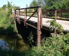 | Big Blue River Bridge | structure | 1992 | 92000708 |
 | Butler County District No. 10 School | building | 2011 | 11000884 |
 | Clear Creek Bridge | structure | 1992 | 92000734 |
 | David City Park and Municipal Auditorium | district | 2000 | 00001378 |
 | Fremont, Elkhorn and Missouri Valley Railroad Depot | building | 1979 | 79003682 |
 | St. Mary of the Assumption Catholic Church, School and Grottoes | district | 2008 | 08001132 |
 | Surprise Opera House | building | 1988 | 88000940 |
 | Chauncey S. Taylor House | building | 1982 | 82003184 |
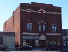 | Thorpe's Opera House | building | 1988 | 88000941 |
 | Upper Oak Creek Descent Ruts of the Woodbury Cutoff, Ox Bow Trail of the California Road | site | 1992 | 92001572 |
Every wildfire the federal occurrence database records inside this county: 93 of them, burning about 697 acres. 1 started naturally and 9 were recorded as arson. Each settlement page carries the fires within five miles of it.
| Reported cause | Fires |
|---|---|
| Debris and open burning | 36 |
| Equipment and vehicle use | 26 |
| Missing data/not specified/undetermined | 13 |
| Arson/incendiarism | 9 |
| Smoking | 7 |
| Recreation and ceremony | 1 |
| Natural | 1 |
The five largest, by the area the report gives. Four of them were set deliberately.
| Date | Cause | Size | Reported by | Name on the report |
|---|---|---|---|---|
| 19 May 2010 | Arson/incendiarism | 80 acres | Nebraska Forest Service | not named |
| 6 April 2011 | Debris and open burning | 80 acres | Nebraska Forest Service | not named |
| 19 March 2009 | Arson/incendiarism | 60 acres | Nebraska Forest Service | not named |
| 29 October 2005 | Equipment and vehicle use | 60 acres | Nebraska Forest Service | not named |
| 6 March 2017 | Equipment and vehicle use | 40 acres | Nebraska Forest Service | not named |
| 6 January 2009 | Arson/incendiarism | 25 acres | Nebraska Forest Service | not named |
| 1 April 2009 | Arson/incendiarism | 20 acres | Nebraska Forest Service | not named |
| 16 March 2011 | Equipment and vehicle use | 20 acres | Nebraska Forest Service | not named |
Every settlement page carries the fires within five miles of it - see the settlement index below.
The NOAA Storm Events Database holds 372 reports for this county, causing no deaths, 13 injuries and about $37,417,500 in recorded property damage. Each settlement page carries the reports that name it.
| Kind of event | Reports |
|---|---|
| Hail | 179 |
| Thunderstorm Wind | 118 |
| Tornado | 37 |
| Flash Flood | 14 |
| Flood | 14 |
| Heavy Rain | 5 |
| Funnel Cloud | 4 |
| Lightning | 1 |
The most serious of them, by death, then injury, then recorded damage. The accounts are quoted exactly as the forecast office filed them.
| When | Event | Place named | Harm | What the report says |
|---|---|---|---|---|
| May 2004 | Thunderstorm Wind | Rising City | 7 hurt | See narrative below. |
| June 1953 | Tornado (F2) | not stated | 2 hurt, $250,000 | no account filed |
| June 1953 | Tornado (F1) | not stated | 2 hurt, $25,000 | no account filed |
| June 2003 | Thunderstorm Wind | Rising City | 1 hurt | Thunderstorm wind gusts estimated at 70 mph downed power poles and trees northwest of Rising City. The winds flipped a semi-tractor trailer hauling playground equipment near the junction of highways 92 and 81 causing minor injuries to a passenger. Around 1600 customers lost power in Butler county due to downed power lines. |
| August 1952 | Tornado (F3) | not stated | 1 hurt | no account filed |
| March 1990 | Tornado (F4) | not stated | $25,000,000 | no account filed |
| September 2007 | Hail | David City | $4,000,000 | Hail up to 2 inches in diameter damaged at least several hundred vehicles in town and also caused roof damage to a few hundred homes. The main damage path was from the southwest into the northeast part of town with the damage estimated at $4 million. |
| April 1985 | Tornado (F1) | not stated | $2,500,000 | no account filed |
| May 1980 | Tornado (F1) | not stated | $2,500,000 | no account filed |
| April 1978 | Tornado | not stated | $2,500,000 | no account filed |
| June 1996 | Tornado (F1) | Abie | $150,000 | no account filed |
| August 2017 | Flash Flood | Octavia | $100,000 | Highway 15 was closed due to flooding and debris in the road. In addition numerous county roads were closed across Butler County. |
| August 2017 | Flood | Garrison | $100,000 | At least 50 roads were closed across Butler County due to widespread flooding with amounts of 4 to 6 inches reported. David City reported 6.01 inches of rain. |
| June 1997 | Thunderstorm Wind | David City | $100,000 | At David City, strong winds collapsed a large airport hanger and toppled at least five center pivots irrigation systems. Trees fell on two homes in the Surprise area causing damage. Severe tree damage occurred at Garrison and Rising City. Many power lines were downed. |
| May 2024 | Flash Flood | Bruno | $25,000 | The Butler County Emergency Manager reported flooding in Bruno, and in rural areas just to the south and eat of the town. Many roads were under water, particularly in the Skull Creek area. |
| April 1978 | Tornado | not stated | $25,000 | no account filed |
| June 1970 | Tornado (F2) | not stated | $25,000 | no account filed |
| August 1959 | Tornado | not stated | $25,000 | no account filed |
| May 1995 | Thunderstorm Wind | Brainard | $15,000 | Wind damage to trees and building destroyed. |
| October 2000 | Tornado (F0) | Rising City | $13,000 | A tornado touched down around 1 mile east of Rising City. Moving north, it damaged a corn crib and an old garage around 6 miles south of Bellwood and then overturned 2 center pivots and downed a few trees and power lines before lifting around 5 miles south of Bellwood. |
| June 2010 | Flash Flood | Bellwood | $10,000 | Rainfall of 2 inches or so in about an hour caused flash flooding across various county roads and portions of Highways 15 and 64 in northwest Butler county. The rain fell on saturated soils due to heavy rain that fell earlier in the week. Damage from this flooding consisted mainly of gravel washed off county roads and some crop damage. |
| June 2000 | Thunderstorm Wind | David City | $10,000 | Thunderstorm winds estimated at over 70 mph did considerable tree damage in David City including downing several trees. Building material near the fairgrounds was also tossed around damaging several cars in the area. |
| June 1996 | Tornado (F0) | Loma | $10,000 | no account filed |
| June 2010 | Flood | Ulysses | $6,000 | Rainfall of 2 to 4 inches on 6/20 caused flooding along the Big Blue River from near Surprise to near Ulysses. The river at Surprise crested at close to 8 feet in the afternoon of 6/21, flood stage is 7 feet. The river was above flood stage at Surprise from the morning until the evening of 6/21. The flooding affected mainly farmland near the river but a few county roads were also flooded. |
| September 2014 | Flood | Surprise | $5,000 | The Big Blue River rose above flood stage on the evening of the 11th, and then crested in the early morning on the 12th before falling below flood stage later on the same day. The flooding was minor and confined to low-lying areas along the river. |
| August 1996 | Thunderstorm Wind | David City | $5,000 | no account filed |
| June 1997 | Thunderstorm Wind | Surprise | $3,000 | no account filed |
| May 1992 | Tornado (F0) | not stated | $2,500 | no account filed |
| July 1988 | Tornado (F0) | not stated | $2,500 | no account filed |
| June 1971 | Tornado (F0) | not stated | $2,500 | no account filed |
| June 1957 | Tornado (F1) | not stated | $2,500 | no account filed |
| May 2018 | Flood | Bellwood | $1,000 | Between 1 1/2 to 2 inches of heavy rain fell across northern Butler County.This caused water in a low lying area near the the Platte River to overflow across County Road 44 between County Roads E and F. |
| July 2011 | Flood | Surprise | $1,000 | Rainfall of 3 to 5 inches fell across sections of the upper Big Blue River west of Surprise. The heavy rain caused the Big Blue River near Surprise to exceed its 7 foot flood stage for a little over 24 hours. The flooding affected mainly agricultural lowlands along the river. |
| May 2011 | Flood | Surprise | $1,000 | Rainfall of around 3 inches in several hours caused flooding along the upper reaches of the Big Blue River near Surprise. The river near Surprise crested at little over 8 feet a little before midnight CST on the 12th, flood stage is 7 feet. Flooding mainly affected agricultural lowlands but also flooded a county road or two in the area. |
| May 2011 | Flash Flood | Surprise | $1,000 | Heavy rain, around 3 inches in a few hours in the Surprise area, caused the Big Blue River and some small tributaries to flood in the Surprise area. The flooding mainly affected agricultural lowlands, but a few roads were also flooded for a bit. |
| October 2000 | Thunderstorm Wind | Bellwood | $1,000 | Thunderstorm wind gusts estimated at over 60 mph blew some power lines down by Bellwood and blew the roof off of a garage. |
| July 1958 | Tornado (F0) | not stated | $250 | no account filed |
| June 1957 | Tornado (F1) | not stated | $250 | no account filed |
| April 2026 | Hail | Dwight | - | Emergency management report of hail estimated at 1.75 inches in diameter with lots of quarter sized hail mixed in. Hail caused damage to vinyl siding. |
| April 2026 | Hail | Dwight | - | Delayed report from emergency management of hail up to ping pong ball sized with wind-driven damage to windows and siding. |
| April 2026 | Hail | Dwight | - | Trained spotter report of hail measured at 1.50 inches in diameter with corresponding photographs shared on social media. |
| April 2026 | Hail | Ulysses | - | Public report of hail estimated at 1.00 inch in diameter. |
| April 2026 | Hail | Dwight | - | Public report of hail estimated at 1.25 inches in diameter. |
| April 2026 | Hail | Dwight | - | Trained spotter report of hail estimated at 2.00 inches in diameter. |
| May 2025 | Hail | Millers Fld Arpt | - | NWS Employee report of hail measured up to 1.75 in diameter. |
| May 2025 | Thunderstorm Wind | Bruno | - | Trained spotter report of wind gusts estimated at 50 to 60 mph along with pea sized hail. |
| April 2025 | Thunderstorm Wind | David City | - | Personal weather station measured gust of 82 mph. |
| April 2025 | Hail | David City | - | Public report of hail estimated up to 2.4 in diameter. Delayed report with the time estimated from radar. |
| July 2025 | Thunderstorm Wind | Bellwood | - | Law enforcement report of several trees uprooted and branches broken. Wind speed estimated at 60-65 mph along the outflow boundary of a thunderstorm. |
| July 2025 | Thunderstorm Wind | Nimburg | - | Mesonet measured wind gust of 60 mph along the outflow boundary of a thunderstorm. |
| July 2025 | Thunderstorm Wind | Brainard | - | Personal weather station measured wind gust of 65 mph along the outflow boundary of a thunderstorm. |
| September 2025 | Thunderstorm Wind | Brainard | - | Photos shared via social media of a destroyed outbuilding and a large, downed tree branch which did damage to the roof of a home. Time estimated based on radar. |
| April 2024 | Funnel Cloud | Brainard | - | The Butler County Emergency Manager reported a funnel cloud just to the southwest of Brainard. |
| April 2024 | Hail | Ulysses | - | The Butler County Emergency Manager reported golf ball sized hail in downtown Ulysses. |
| May 2024 | Tornado (EF0) | Brainard | - | This brief tornado touched down a quarter mile north of 28 Road and a quarter mile west of Q Road, and tracked east for approximately two-thirds of a mile before dissipating. On the west side of Q road, a center pivot was overturned. Several hardwood trees were blown down on the east side of Q road. This tornado had peak estimated winds of 84 miles per hour, with a max width of 50 yards and an estimated mean width of 40 yards. |
| May 2024 | Tornado (EF0) | Loma | - | This tornado touched down approximately half a mile east of T Road on 28 Road where tree branches were snapped off trees and littered across the road. This tornado then continued east along 28 Road to V Road snapping branches of trees along its way. Just after it crossed V Road, trees along 28 Road were sheared off at their tops. The tornado then continued east where it dissipated a quarter mile east of W Road. At the time of dissipation, a farm outbuilding had pieces of its roof paneling blown off. The peak estimated winds in this tornado were 80 miles per hour, with a max width at 50 yards and an estimated average width of 40 yards. |
| May 2024 | Thunderstorm Wind | Bellwood | - | The Butler County Emergency Manager reported several center pivots overturned and multiple power poles snapped from the intersection of U.S. Highway 80 and State Highway 64 East towards Bellwood. A damage survey also found an empty grain bin that had been blown off its foundation and smashed against the side of a farm building. |
| April 2024 | Tornado (EFU) | Brainard | - | Trained spotters with video and photo confirmation reported a tornado lasting approximately 1 minute over open fields. There was no damage found from this tornado, so its width and wind speeds were not able to be accurately estimated. |
| July 2024 | Flood | Surprise | - | Flooding from excessive rain runoff was noted at the Surprise river gauge (SRPN1) along the Big Blue River in southwestern Butler county. The river gauge crested at 2 am CST on the 2nd at a height of 7.57 feet. Flood stage continued until 2 am CST on the 4th. |
| April 2024 | Tornado (EF1) | Dwight | - | Several trained spotters observed a tornado that began near the intersection of Highway 15 and Ashland Road. It moved to the north-northeast as a broad multiple vortex tornado, but the overall motion was observed to be relatively weak despite the tornado's width. The tornado snapped several trees and a road sign near the intersection of Highway 15 and 66. It continued nearly due north from that location with very little damage along an intermittent track, but it did overturn multiple center pivot irrigation systems. While the funnel was often not fully condensed, there was a rather persistent dust whirl below the base of the funnel all the way north to near Road 29 just east of Highway 15. Near the time of its demise, a second brief tornado developed just 1 mile to the east of this tornado. The peak winds in this tornado were estimated to be at 100 miles per hour. The tornado was estimated to be 200 yards across at its widest, with an average width of 100 yards during its lifespan. |
The Survey's mineral resources record lists 1 working inside this county. It still produces. Each settlement page carries the workings within five miles of it.
| Commodity | Workings |
|---|---|
| Sand and Gravel, Construction | 1 |
The least common of them first, because a county's hundredth gravel pit says nothing its first ten did not.
| Where | Site | Commodity | Status | Recorded |
|---|---|---|---|---|
| Pb 3 Pit and Plant | Sand and Gravel, Construction | Producer |
Named settlements recorded in the Geographic Names Information System, each with the topographic sheets covering it. Villages, hamlets and abandoned places alike. Each is shown with the nearest named watercourse or landform and the survey quadrangle it falls on.
Ulysses township · 68669 · On North Branch Big Blue River · Ulysses quadrangle
11 sheets, 1899 to 1985