 Block
From the record
14 National Register listings published here.
Sources: the National Register database, National Park Service
54 topographic sheets cover 22 settlements here, and 14 properties are on the National Register of Historic Places.
14 National Register listings published here.
Sources: the National Register database, National Park Service
Every property in this county listed on the National Register of Historic Places, with the year it was listed and the federal nomination document.
| Photograph | Property | Type | Listed | Reference |
|---|---|---|---|---|
 | Argo Hotel | building | 1999 | 99000478 |
 | Commercial Hotel, The | building | 1990 | 90000563 |
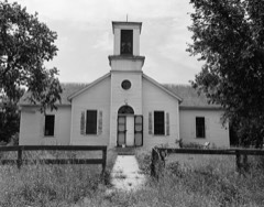 | Congregational Church and Manse | building | 1972 | 72000753 |
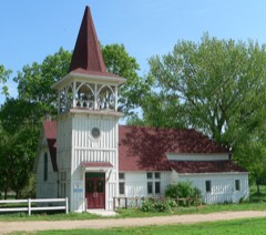 | Episcopal Church | building | 1972 | 72000754 |
 | Gross State Aid Bridge | structure | 1992 | 92000773 |
 | Knox County Courthouse | district | 1990 | 90000972 |
 | Niobrara River Bridge | structure | 1992 | 92001576 |
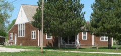 | Ponca Tribal Self-Help Community Building Historic District | district | 2003 | 03000106 |
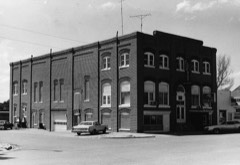 | Pospeshil Theatre | building | 1988 | 88000935 |
 | St. Rose of Lima Catholic Church and School Complex | building | 2011 | 11000106 |
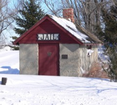 | Winnetoon Jail | building | 1995 | 95000094 |
| Winnetoon Public School | building | 2020 | 100005053 | |
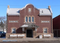 | Z.C.B.J. Opera House | building | 1988 | 88000946 |
Every wildfire the federal occurrence database records inside this county: 101 of them, burning about 9,048 acres. 2 started naturally and 2 were recorded as arson. Each settlement page carries the fires within five miles of it.
| Reported cause | Fires |
|---|---|
| Debris and open burning | 51 |
| Equipment and vehicle use | 20 |
| Missing data/not specified/undetermined | 11 |
| Smoking | 5 |
| Power generation/transmission/distribution | 3 |
| Misuse of fire by a minor | 3 |
| Recreation and ceremony | 2 |
| Natural | 2 |
| Arson/incendiarism | 2 |
| Fireworks | 2 |
The five largest, by the area the report gives. None of them was recorded as arson.
| Date | Cause | Size | Reported by | Name on the report |
|---|---|---|---|---|
| 10 March 2012 | Debris and open burning | 2,464 acres | Winnebago Agency | SIX PACK |
| 5 October 2011 | Equipment and vehicle use | 1,200 acres | Nebraska Forest Service | not named |
| 19 July 2002 | Equipment and vehicle use | 870 acres | Winnebago Agency | A1302105 |
| 13 March 2015 | Debris and open burning | 700 acres | Nebraska Forest Service | not named |
| 16 March 2015 | Debris and open burning | 700 acres | Nebraska Forest Service | not named |
| 29 April 2018 | Missing data/not specified/undetermined | 640 acres | Nebraska Forest Service | not named |
| 12 April 2018 | Debris and open burning | 600 acres | Nebraska Forest Service | not named |
| 8 April 2014 | Misuse of fire by a minor | 350 acres | Winnebago Agency | BASIL |
Every settlement page carries the fires within five miles of it - see the settlement index below.
The NOAA Storm Events Database holds 549 reports for this county, causing 1 death, 112 injuries and about $9,513,060 in recorded property damage. Each settlement page carries the reports that name it.
| Kind of event | Reports |
|---|---|
| Hail | 317 |
| Thunderstorm Wind | 143 |
| Tornado | 46 |
| Flood | 20 |
| Flash Flood | 17 |
| Heavy Rain | 3 |
| Lightning | 2 |
| Funnel Cloud | 1 |
The most serious of them, by death, then injury, then recorded damage. The accounts are quoted exactly as the forecast office filed them.
| When | Event | Place named | Harm | What the report says |
|---|---|---|---|---|
| May 1959 | Tornado (F2) | not stated | 1 killed, 2 hurt, $250,000 | no account filed |
| June 1950 | Tornado (F2) | not stated | 101 hurt, $25,000 | no account filed |
| July 1984 | Hail | not stated | 5 hurt | no account filed |
| May 2007 | Tornado (EF2) | Crofton | 3 hurt, $1,000,000 | A grain bin was damaged as this tornado initially touched down along with two or three large power line support structures northwest of Crofton. The tornado tracked toward Lewis and Clark Lake taking the roof off of a house and destroying a garage. The tornado also caused other roof damage as it continued tracking toward Lewis and Clark Lake. When it reached the lake it caused significant damage to a recreation area and marina. The tornado also caused 3 minor injuries when it apparently lifted a large SUV off the ground and carried it a hundred feet or so before setting it down with the windows blown in. Numerous campers and boats were flipped or missing at the recreation area, along with vehicle damage. About $1 million in damage was estimated to have occurred at the recreation area. Many trees were also toppled. This tornado and others in Knox county downed 30 to 40 power poles. A Storage building in the area was also severely damaged. This tornado started as one tornado to the southwest was lifting and a weaker one to the northeast was forming. There were several reports by the public of multiple tornadoes in the area, either from the three tornadoes mentioned here, or from multiple vortexes within this tornado. The tornado crossed Lewis and Clark Lake and did f1 damage in South Dakota. |
| April 1994 | Tornado (F1) | Bloomfield | 1 hurt, $500,000 | A small tornado touched down about four and a half miles south of Bloomfield. One person was injured as he took cover in a ditch as the tornado approached. Debris from a building fell on him and broke his leg. There was damage to outbuildings and irrigation systems on more than a dozen farms. |
| April 1985 | Tornado (F2) | not stated | $2,500,000 | no account filed |
| June 2000 | Hail | Crofton | $1,500,000 | A hail storm began northwest of Crofton Nebraska and cut a half mile wide swath of damage down to Hartington in Cedar county. Hail, which at times was baseball size, was driven by 50 mph winds causing extensive damage to cars, windows, siding, roofs and crops in the area. Insurance agents stated that between 1 and 2 million dollars in damage was sustained from around Crofton through Hartington. The worst damage was reported at the junction of Highways 81 and 12, 5 miles east of Crofton. Around the junction of Higways 12 and 81 local agronomists estimated that defoliation of corn was in the 85 to 90 percent range with 35 percent of the crop dead. |
| March 2019 | Flood | Verdel | $1,200,000 | This is for flooding along the Niobrara River. The river gauge at Verdel, operated by the USGS, peaked at 19.38 feet at 6 pm on March 13th. Major flood stage is 10 feet. This peak is the highest on record. This gauge was destroyed by ice and floodwaters during the event. The high water value was obtained post-flood by the USGS. This historic flooding along the Niobrara River was the result of rain, snowmelt and the failure of the upstream Spencer Dam. The dam failed due to overtopping with some estimates of 3 to 5 feet of water going over the dam. The resulting wave of water from this dam failure caused substantial damage in low-lying areas of the town of Niobrara. Damage was somewhat isolated in regards to the whole town, but what was affected was absolutely devastated. Major damage sustained to the Country Cafe, and farm buildings next door. Thick river ice slabs 2-3 ft thick also contributed to damage, with the Country Cafe having most of its walls lost due to ice. The owner said when they arrived, the ice piles left behind from the flood were close to 10 ft high and completely surrounded the Cafe up to the roof. Measured a 6.4 ft high water mark in the cafe. The Highway 12 bridge was washed out in two sections on the west side of the river channels. Property damage amounts are for the entire county. |
| August 1993 | Thunderstorm Wind | Bloomfield | $500,000 | A severe thunderstorm with strong downburst winds passed over Bloomfield. A small hangar at the airport was destroyed, some buildings were damaged around town, and a few trees were blown down. |
| May 1992 | Tornado (F1) | not stated | $250,000 | no account filed |
| May 1992 | Tornado (F1) | not stated | $250,000 | no account filed |
| June 1981 | Tornado (F1) | not stated | $250,000 | no account filed |
| October 1980 | Tornado (F1) | not stated | $250,000 | no account filed |
| October 1980 | Tornado (F1) | not stated | $250,000 | no account filed |
| June 2011 | Flood | Verdel | $150,000 | Flooding along the Missouri River gradually worsened over the area during June as record releases from Ft. Randal Dam brought widespread flooding along the river. In Knox county the flooding closed Highway 12 between Verdel and Niobrara and east of Niobrara and also closed Highway 14/37 north of Niobrara. The flooding also forced the evacuation of 50 to 60 residences including the Lazy River Acres area in between Niobrara and Verdel. The flooding carried over into July. |
| August 2011 | Flood | Verdel | $50,000 | Flooding along the Missouri River gradually worsened over the area during June and July and persisted into August as record releases due to heavy rain and mountain snow melt above Ft. Randal Dam brought widespread flooding along the River. In Knox county the flooding closed Highway 12 between Verdel and Niobrara and the highway east of Niobrara and also closed Highway 14/37 north of Niobrara. The flooding also forced the evacuation of 50 to 60 residences including the Lazy River Acres area between Niobrara and Verdel. The flooding carried over into September. |
| July 2011 | Flood | Verdel | $50,000 | Flooding along the Missouri River gradually worsened over the area during June and persisted through July as record releases from Ft. Randal Dam brought widespread flooding along the River. In Knox county the flooding closed Highway 12 between Verdel and Niobrara and east of Niobrara and also closed Highway 14/37 north of Niobrara. The flooding also forced the evacuation of 50 to 60 residences including the Lazy River Acres area in between Niobrara and Verdel. The flooding carried over into August. |
| June 2000 | Hail | Verdigre | $50,000 | Damage to vehicles and roofs. |
| July 2010 | Flood | Niobrara | $35,000 | Rainfall of at least 4 to 8 inches fell across the Ponca Creek basin from late in the evening of the 21st into the early morning hours of the 22nd. The heavy rain caused flooding along Ponca Creek for much of July 22nd. The creek near Verdel crested a little over 14.5 feet during the early afternoon hours of the 22nd, flood stage is 12 feet. The flooding caused numerous washouts of county roads and and also flooded Highway 12 along with agricultural lowlands. Several culverts needed replacement after the flood. There was also significant flooding of a resort near the Missouri River close to where Ponca Creek flows into it with over 2 feet of water reported in the campground. |
| August 2017 | Flash Flood | Creighton | $30,000 | Heavy rains caused flooding along Highway 13 south/southwest of Creighton. |
| October 1996 | Thunderstorm Wind | Niobrara | $30,000 | no account filed |
| May 2011 | Flood | Verdel | $25,000 | Heavy rain on the upper Missouri River basin and then high releases from Missouri River Reservoirs brought prolonged flooding along the Missouri River. In Knox county the flooding closed Highway 12 east of Verdel and east of Niobrara and also closed Highway 14/37 north of Niobrara. The flooding also forced the evacuation of Lazy River Acres which was in between Niobrara and Verdel. The flooding carried over into and got progressively worse in June. |
| July 1996 | Hail | Crofton | $25,000 | no account filed |
| May 1992 | Tornado (F1) | not stated | $25,000 | no account filed |
| May 1992 | Tornado (F1) | not stated | $25,000 | no account filed |
| April 1985 | Tornado (F1) | not stated | $25,000 | no account filed |
| June 1976 | Tornado (F1) | not stated | $25,000 | no account filed |
| May 1975 | Tornado (F0) | not stated | $25,000 | no account filed |
| June 1971 | Tornado (F0) | not stated | $25,000 | no account filed |
| May 1959 | Tornado (F1) | not stated | $25,000 | no account filed |
| July 2010 | Flash Flood | Verdel | $20,000 | Rainfall of 5 to 6 inches fell south of Verdel causing flash flooding along small creeks in the area. According to the cooperative observer south of Verdel the flooding washed out 6 to 7 small earth dams as water around a quarter mile wide flooded out trees, fences and other objects in its path in the area. |
| May 2000 | Thunderstorm Wind | Creighton | $20,000 | Thunderstorm winds snapped 1 large tree in half and uprooted another one. One of the trees fell on a house causing considerable roof damage and damage to the west side of the house. |
| June 2010 | Flood | Verdel | $15,000 | Heavy rain from June 8th through the morning of the 11th caused Ponca Creek to flood along sections of Highway 12 near Verdel. Additional heavy rain the next few nights caused it to remain above its 12 foot flood stage until the early evening hours of June 15th. The creek crested at 14.8 feet during the late afternoon of June 12th. The flooding mainly affected agricultural lowlands along the stream, but a few county roads were flooded and a bridge south of Highway 12 on a county road was washed out. |
| July 2010 | Flood | Verdel | $15,000 | Rainfall of at least 4 to 8 inches fell across the lower Niobrara River basin late in the evening of the 21st into the early morning hours of the 22nd. This caused the Niobrara River to flood across the Jct of Highways 12 and 14 near Niobrara swamping at least one vehicle. A few other roads in the area also flooded. At its peak almost 20,000 cfs of water was flowing down the Niobrara, compared to normal flows of 1,000 cfs. According to NPPD records, spillway gates from an upstream reservoir were opened for the first time since 1966 to relieve water pressure against the dam. The high water also flooded a local golf course and surrounding agricultural land. |
| July 2010 | Flash Flood | Verdel | $15,000 | Rainfall of 4 to 6 inches fell in about a 4 to 6 hour period along the Ponca Creek basin. The heavy rain caused a rapid rise of Ponca Creek which flooded areas along the creek east and west of Verdel. Some county roads and Highway 12 near the creek were flooded along with agricultural lowlands. Several washouts of county roads occurred. |
| June 2024 | Flood | Verdel | $10,000 | Slow-moving training thunderstorms across north-central Nebraska dropped a large swath of 3 to 6 inches of rain in the Ponca Creek drainage basin the 20th into the 21st. This resulted in moderate flooding along Ponca Creek near Verdel. The creek crested at 15.71 feet at 0000 CDT on the 23rd. Flood stage at this river gauge site is 13.5 feet. Reports were received from North Platte of water approaching the bottoms of rural bridges over the stream with significant tree debris in the water. The county in response to the flooding sandbagged around vulnerable homes and buildings along the creek bank. |
| September 2010 | Flash Flood | Crofton | $10,000 | Rainfall of over 7 inches was reported in less than 24 hours in the Crofton area. The second round of heavy rain to hit the area during the evening of the 22nd produced flash flooding of streets and a park in Crofton. Two sections of the fence around a baseball field were taken out by flood waters. |
| July 2010 | Flood | Niobrara | $10,000 | Rainfall of 4 to 6 inches fell across much of this area during the night of July 21st and 22nd. The heavy rain produced flooding along Bazile Creek which flooded across Highway 12 east of Niobrara depositing some debris and causing its temporary closure. A Few county roads in the area were also flooded as were agricultural lowlands near the Creek. |
| May 2007 | Tornado (EF0) | Center | $10,000 | This tornado tracked north through a very rural area with most roads in the area minimum maintenance with limited access. A machine shed was destroyed and a trailer overturned northeast of Center and 6 cattle were killed in the area. But generally any damage was confined to old deserted farm sites along with trees in the area. |
| May 1999 | Tornado (F0) | Creighton | $10,000 | Power lines/poles downed. |
| August 1997 | Thunderstorm Wind | Verdigre | $6,000 | Many trees and power lines downed. |
| September 2011 | Flood | Verdel | $5,000 | Flooding along the Missouri River, which worsened over the area during June and July, persisted into August before moderating late in that month and in September. Record releases due to heavy rain and mountain snow melt above Ft. Randal Dam brought the widespread flooding along the river. In Knox county at its height the flooding closed Highway 12 between Verdel and Niobrara and the highway east of Niobrara and also closed Highway 14/37 north of Niobrara. However, the highways had reopened by early September. Earlier the flooding had forced the evacuation of 50 to 60 residences including the Lazy River Acres area between Niobrara and Verdel. |
| August 1997 | Thunderstorm Wind | Center | $3,000 | Roof blown off a shed. |
| June 1977 | Tornado (F1) | not stated | $2,500 | no account filed |
| June 1975 | Tornado (F2) | not stated | $2,500 | no account filed |
| May 1960 | Tornado (F0) | not stated | $2,500 | no account filed |
| May 1960 | Tornado (F0) | not stated | $2,500 | no account filed |
| August 1956 | Tornado (F0) | not stated | $2,500 | no account filed |
| July 2024 | Thunderstorm Wind | Center | $2,000 | Law enforcement reported damage to wind screens and trees at a food lot. |
| September 2010 | Flash Flood | Santee | $2,000 | Rainfall of 6 to 7 inches fell on Sept. 22nd which produced flash flooding along Bazile Creek reducing Highway 12 to one lane east of Niobrara. |
| June 2010 | Flash Flood | Creighton | $2,000 | Rainfall of around 3.5 inches caused flash flooding and evacuation of campers at Bruce Park in Creighton. Creighton's city hall also sustained substantial water damage due to the heavy rain which ponded on the roof and then leaked around a flashing. |
| August 1996 | Lightning | Verdel | $500 | no account filed |
| June 1986 | Tornado (F0) | not stated | $30 | no account filed |
| May 1986 | Tornado (F0) | not stated | $30 | no account filed |
| July 2025 | Hail | Niobrara | - | Emergency management report of hail measured up to 1 inch in diameter. Time estimated from radar. |
| July 2025 | Hail | Venus | - | Trained spotter report of hail estimated up to 1 inch in diameter. |
| July 2025 | Thunderstorm Wind | Creighton Arpt | - | Personal weather station measured wind gust of 58 mph. |
| June 2025 | Hail | Crofton | - | Report of hail, mostly dime sized but a few quarter sized hail stones mixed in. |
| July 2025 | Hail | Winnetoon | - | Trained spotter report of hail nearing tennis ball-size from chaser live stream. Time estimated from radar on Highway 14 West of Winnetoon, NE. |
| May 2024 | Hail | Bloomfield | - | A swath of severe hail started in Bloomfield, Nebraska with half dollar sized hail being reported by the public on the north side of town. As the storm moved northeast, severe hail fell in mainly rural areas before entering the town of Crofton where golf ball sized hail was reported. |
The Survey's mineral resources record lists 2 workings inside this county. All of them still produce. Each settlement page carries the workings within five miles of it.
| Commodity | Workings |
|---|---|
| Sand and Gravel, Construction | 2 |
The least common of them first, because a county's hundredth gravel pit says nothing its first ten did not.
| Where | Site | Commodity | Status | Recorded |
|---|---|---|---|---|
| Crosley Sand & Gravel Pit & Plant | Sand and Gravel, Construction | Producer | ||
| Selders Sand & Gravel Pit & Plant | Sand and Gravel, Construction | Producer |
Named settlements recorded in the Geographic Names Information System, each with the topographic sheets covering it. Villages, hamlets and abandoned places alike. Each is shown with the nearest named watercourse or landform and the survey quadrangle it falls on.
Creighton township · 68729 · On Spring Creek · Center West quadrangle
10 sheets, 1955 to 1985
Niobrara township · 68760 · On Niobrara River · Niobrara quadrangle
11 sheets, 1950 to 1989
Western township · 68783 · On Pishel Creek · Pishelville quadrangle
10 sheets, 1950 to 1989