 Block
Lake Arthur, New Mexico
9 topographic sheets cover this place, the earliest surveyed in 1954 and the latest in 1978. It stands in the Hagerman census division. It lies in ZIP code area 88253. It stands on Walnut Creek. The Survey maps it on the Artesia NE quadrangle. 378 people lived here at the 2020 count. It stands 3,379 feet above sea level.
On record in Lake Arthur
Buildings and businesses the archive holds for this place. Each opens its own page, with the source record it came from.
On the National Register 1 record
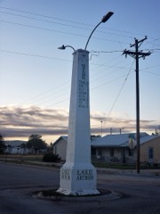 Ozark Trails Marker at Lake Arthurlisted 2004
Population over time
2 figuresLake Arthur fell from 436 to 378 between 2010 and 2020. These are the recorded population figures Wikidata holds for this place, reached through the Geographic Names Information System number this page is keyed on rather than by name, so they belong to this place and not to another of the same name. Most are census counts, but not all are: an early figure may be a founding or settlement estimate, and an estimate published within five years of a census is left out. The change column is computed, and is left blank where more than 20 years separate a figure from the one before it, because a gap that long is not a change between two counts.
| Year | People | Change |
|---|---|---|
| 2010 | 436 | |
| 2020 | 378 | -58 (-13%) |
Topographic sheets covering this place
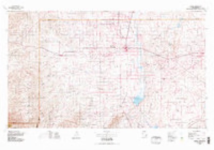
4 surveys from 9 printed sheetsMatched by testing this settlement's coordinate against the published boundary of every sheet in the United States Geological Survey's historical collection. Each opens the scanned sheet at the Survey.
- 1954 USGS Carlsbad quadrangle1:250000, 3 printings
- 1955 USGS Artesia NE quadrangle1:24000, 3 printings
- 1958 USGS Carlsbad quadrangle1:250000, 2 printings
- 1978 USGS Artesia quadrangle1:100000
Fires near this place
45 since 1992Regional context, not property-specific evidence. The federal wildfire occurrence database lists 45 fires within 5 miles of Lake Arthur between 1992 and 2020, burning about 2,373 acres in total. 2 started naturally. None was recorded as arson. Distance is straight-line from the map coordinates, so a fire counted here may appear on a neighbouring settlement's page as well.
| Reported cause | Fires |
|---|---|
| Missing data/not specified/undetermined | 29 |
| Equipment and vehicle use | 8 |
| Debris and open burning | 3 |
| Natural | 2 |
| Railroad operations and maintenance | 1 |
| Power generation/transmission/distribution | 1 |
| Smoking | 1 |
The most recent of them, most recent first, with the day each was reported and the service that recorded it.
| Date | Cause | Size | Reported by | Name on the report |
|---|---|---|---|---|
| 8 August 2005 | Missing data/not specified/undetermined | 110 acres | Roswell Field Office | PUEBLO2 |
| 28 August 2014 | Equipment and vehicle use | under an acre | New Mexico State Forestry Division | FISHER |
| 12 August 1998 | Missing data/not specified/undetermined | under an acre | New Mexico State Forestry Division | SPENCE II |
| 12 August 1998 | Missing data/not specified/undetermined | under an acre | New Mexico State Forestry Division | SPENCE |
| 26 July 2016 | Natural | under an acre | Carlsbad Field Office | BUFFALO |
| 26 July 2005 | Missing data/not specified/undetermined | 47 acres | Roswell Field Office | PUEBLO |
| 26 July 2005 | Natural | 37 acres | Roswell Field Office | ARTHUR |
| 19 July 2015 | Missing data/not specified/undetermined | under an acre | Roswell Field Office | POST |
Settlements close enough to share some of these fires:
Mines and quarries near this place
3 within 5 milesRegional context, not property-specific evidence. The federal mineral resources record lists 3 workings within 5 miles of Lake Arthur: 2 unknowns, 1 past producer. None of them still produces. What was taken out: Sand and Gravel, Construction. Distance is straight-line from the map coordinates, so a quarry counted here may appear on a neighbouring settlement's page as well.
| Where | Site | Commodity | Status | Recorded |
|---|---|---|---|---|
| Gravel Pit | Sand and Gravel, Construction | Unknown | ||
| Gravel Pit | Sand and Gravel, Construction | Unknown | ||
| Materials Pit | Sand and Gravel, Construction | Past Producer |
Storms near this place
43 since 1995Regional context, not property-specific evidence. The National Weather Service names Lake Arthur in 43 storm reports between 1995 and 2025: 20 hail, 14 flash flood, 4 thunderstorm wind, 2 tornado. The reports record 4 deaths and 7 injuries. Each account below is quoted exactly as the forecast office filed it, from the NOAA Storm Events Database, and each date opens the federal record of that event.
| When | Event | Place named | Harm | What the report says |
|---|---|---|---|---|
| July 1996 | Flash Flood | Lake Arthur | 4 killed | no account filed |
| March 2019 | Tornado (EF2) | Lake Arthur | 6 hurt, $2,000,000 | Just before 6 pm MDT on Tuesday, March 12, 2019, a tornado touched down in Chaves County, about 15 miles south southwest of Dexter. The tornado moved north northeast for approximately 15 minutes before dissipating about one half mile northeast of the community of Dexter. Six people suffered minor injuries, and six homes were substantially damaged or completely destroyed. An additional dozen homes and structures also sustained minor to moderate damage. This was the first March tornado documented in Chaves County since 1959, and the earliest known EF1 or stronger tornado in the state of New Mexico. The last EF2 tornado in New Mexico occurred on May 23, 2012. Damage amounts are a rough estimate. |
| August 2015 | Thunderstorm Wind | Lake Arthur | 1 hurt, $10,000 | Spotter reported overturned 18-wheeler along U.S. Highway 285 from severe thunderstorm winds. The driver was injured in the crash and transported to a local hospital. |
| May 2021 | Flash Flood | Lake Arthur | $750,000 | Thunderstorms producing heavy rain resulted in major flash flooding across southern Roswell and southern Chaves County. Heavy rainfall had fallen in the area the previous evening, and an additional 3 to 5 inches of rain during the morning of May 31st exacerbated the flash flooding. Numerous locations along U.S. Highway 285 from Lake Arthur northward into Roswell had upwards of 2 feet of water along the travel corridor while low water crossings had upwards of 4 feet of water which overfilled the banks. Multiple reports of flooding across fields, ditches, yards, and vehicles were reported. Several side roads were unpassable and had to be barricaded. A breached arroyo near the Roswell Airport also forced the closure of roads around the airport for about a week. Damages are estimated. |
| June 2018 | Thunderstorm Wind | Lake Arthur | $150,000 | Three single-wide mobile homes were overturned and destroyed by straight line winds near Sagebrush Valley Road and U.S. Highway 285. All three trailers were supported on concrete blocks with no tie-downs and no skirting. There were no injuries as none of the units were occupied at the time. Several recreational vehicles were also overturned and damaged in the vicinity. A large tree at a residence near Hagerman was toppled and crushed a nearby carport causing damage to one vehicle. Damage amounts are a rough estimate. |
| June 2018 | Thunderstorm Wind | Lake Arthur | $100,000 | A large barn with concrete floors, concrete footings, and large wood beam trusses was completely destroyed by straight line winds. A semi-trailer inside the barn was also overturned. There were no injuries as the structure was unoccupied. Damage amounts are a rough estimate. |
| October 2019 | Flash Flood | Lake Arthur | $20,000 | Additional record rainfall on October 3rd led to another round of flash flooding around Roswell, Lake Arthur, and Portales. The Roswell airport set a new daily record rainfall of 0.95 for October 3rd, breaking the previous record of 0.89 set in 2015. The Bitter Lake Wildlife Refuge set a new daily record rainfall of 1.43 for October 3rd. A trailer park community along U.S. 285 was inundated with water and one home was damaged by flood waters. The area along State Road 2 and U.S. 285 between Jackson Road and Pueblo Road southwest of Lake Arthur was closed due to high water. State Road 409 was closed again due to flash flooding leading to the Bitter Lake Wildlife Refuge. Fortunately, no injuries were reported with the second round of flooding. Damage amounts are estimated for water damage to one trailer home. |
| October 2015 | Flash Flood | Lake Arthur | $20,000 | New Mexico State road 2 closed due to flooding. A motorist was stranded in 3 to 4 feet of water. The road remained closed into the next day. |
| July 2009 | Flash Flood | Lake Arthur | $7,500 | Water overflowed Walnut Creek about 2 miles south of Lake Arthur, flooding a portion of State Road 2. |
| May 2024 | Flash Flood | Lake Arthur | $2,000 | Flash flood waters inundated four culverts beneath State Highway 13 and overtopped the Highway 101 near Brady Road. A 4 foot cattle fence was destroyed, damage is an estimate. The debris field was 2 to 3 feet deep. |
| May 2024 | Hail | Lake Arthur | $1,500 | Golf ball size hail from a severe thunderstorm moving east across southern Chaves County damaged a car travelling along U.S. Highway 285. |
| August 2025 | Flash Flood | Lake Arthur | - | State Road 2 was closed at the intersection with East Jackson Road due to flooding along the normally dry Walnut Arroyo. Based on photo provided, floodwaters looked to be about 1 foot deep and not moving. |
| September 2025 | Flash Flood | Lake Arthur | - | Repeated rounds of moderate to heavy rainfall resulted in standing water estimated up to a foot deep over an estimated one tenth of a mile stretch of highway along NM 13 at mile marker 29 approximately six miles west of U.S. Highway 285. |
| September 2024 | Flash Flood | Lake Arthur | - | A video shared on social media showed a portion of Highway 2 south of Lake Arthur in southern Chaves County under six inches of water. Radar and gauge readings showed the likely period of flooding rains occurred in the morning from 8am to 9am MDT, while the reports were received later in the early afternoon when the heavier rain ended. |
| November 2024 | Flash Flood | Lake Arthur | - | Water from Walnut Creek overflowed onto State Road 2, resulting in the closure of the roadway. |
| May 2024 | Hail | Lake Arthur | - | A resident near the Roswell Correctional Facility reported golf ball sized hail from a severe thunderstorm moving east across southern Chaves County. |
| May 2023 | Hail | Lake Arthur | - | A trained spotter reported nickel to golf ball size hail. |
| May 2023 | Thunderstorm Wind | Lake Arthur | - | Thunderstorm wind gust to 62 mph reported near Lake Arthur. |
| June 2021 | Flood | Lake Arthur | - | Two to four inches of heavy rain that fell in a short period of time forced the closure of New Mexico State Road 2 from mile marker 6 to mile marker 9 near Lake Arthur for several hours. Damage impacts are unknown. |
| June 2019 | Hail | Lake Arthur | - | Golf ball size hail near Hagerman. |
| June 2019 | Tornado (EF0) | Lake Arthur | - | A storm chaser reported a rain-wrapped tornado on the ground several miles west of Hagerman. Location and duration are estimated based on spotter testimony. |
| August 2017 | Flash Flood | Lake Arthur | - | NM-2 closed between mile markers 6 and 8 due to flooding over the roadway. |
| August 2016 | Flash Flood | Lake Arthur | - | Walnut Creek overflowing banks on Spence Road, Jackson Road, and Highway 2 southwest of Lake Arthur. Roadways impassable. |
| June 2014 | Hail | Lake Arthur | - | Hail covered ground near Fox road and SR2. |
| June 2014 | Hail | Lake Arthur | - | Golfball hail covered the ground. |
| June 2014 | Hail | Lake Arthur | - | Hen egg size hail reported on US Highway 285. |
| September 2014 | Flash Flood | Lake Arthur | - | Emergency Manger reported that a motorcyclist was rescued in deep water just off of Highway 285 at Lake Arthur. NM 2 was also closed for multiple hours by the State Police due to standing water on the road. |
| September 2014 | Funnel Cloud | Lake Arthur | - | Video of a funnel cloud in Lake Arthur was posted to social media via the public. |
| May 2012 | Hail | Lake Arthur | - | Quarter size hail reported 2 miles east of Lake Arthur. |
| May 2010 | Hail | Lake Arthur | - | Ping pong ball sized hail started at 405 pm MST. Hail decreased in size to quarters by 415 pm. |
| July 2002 | Heavy Rain | Lake Arthur | - | Heavy rain filled low water crossings along Walnut Creek in far southern Chaves County. State Road 2 had water topping the ditches and into travel lanes near the Chaves-Eddy County line. |
| June 1999 | Flash Flood | Lake Arthur | - | Three feet of water closed low water crossings along Walnut Creek west of Lake Arthur. |
| May 2025 | Hail | Lake Arthur | - | no account filed |
| June 2014 | Hail | Lake Arthur | - | no account filed |
| June 2014 | Hail | Lake Arthur | - | no account filed |
| May 2010 | Hail | Lake Arthur | - | no account filed |
| May 2010 | Hail | Lake Arthur | - | no account filed |
| June 2007 | Hail | Lake Arthur | - | no account filed |
| April 2005 | Hail | Lake Arthur | - | no account filed |
| October 2003 | Hail | Lake Arthur | - | no account filed |
| April 1999 | Hail | Lake Arthur | - | no account filed |
| June 1996 | Hail | Lake Arthur | - | no account filed |
| June 1995 | Hail | Lake Arthur | - | no account filed |
Nearest settlements
The eight closest, with where each one stands in the county. Distances are straight-line, computed from the Geographic Names Information System coordinates.
| Map | Place | Distance | Sheets |
|---|---|---|---|
| Mossman | 3.9 miles | 8 | |
| Hagerman | 8.3 miles | 8 | |
| Greenfield | 11.6 miles | 9 | |
| Lake Van | 13.5 miles | 9 | |
| Blackdom (historical) | 13.7 miles | 8 | |
| Dexter | 13.7 miles | 9 | |
| South Mill | 16.6 miles | 8 | |
| Chisum | 18.4 miles | 9 |
Elsewhere
Matched on this settlement's Geographic Names Information System number rather than its name, so it cannot be a different place of the same name in another state.
| Wikipedia article on Lake Arthur | An encyclopaedic summary. Its text is share-alike, so it is linked here rather than copied. |
| Wikidata item Q2518484 | The structured record the population and elevation above come from. Public domain (CC0). |
Provenance
This settlement is recorded in the Geographic Names Information System as feature 890873. The sheet list is computed by point-in-boundary test against the United States Geological Survey's historical topographic inventory. Both are works of the United States government and carry no copyright under 17 U.S.C. 105.
Wildfire. Short, Karen C. 2022. Spatial wildfire occurrence data for the United States, 1992-2020 [FPA_FOD_20221014]. 6th Edition. Fort Collins, CO: Forest Service Research Data Archive. https://doi.org/10.2737/RDS-2013-0009.6 Collected with United States Government funding and usable without additional permissions or fees.
Mines and quarries. USGS Mineral Resources Data System (MRDS) https://mrdata.usgs.gov/mrds/ A work of the United States government, no copyright under 17 U.S.C. 105.
Storms. NOAA National Centers for Environmental Information, Storm Events Database https://www.ncei.noaa.gov/stormevents/ A work of the United States government, no copyright under 17 U.S.C. 105. Narratives are quoted verbatim from the National Weather Service report and are not edited or summarised.