 Block
Hagerman, New Mexico
8 topographic sheets cover this place, the earliest surveyed in 1951 and the latest in 1979. It stands in the Hagerman census division. It lies in ZIP code area 88232. The Survey maps it on the Hagerman quadrangle. 975 people lived here at the 2020 count. It stands 3,422 feet above sea level.
On record in Hagerman
Buildings and businesses the archive holds for this place. Each opens its own page, with the source record it came from.
On the National Register 1 record
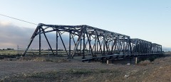 Rio Felix Bridge At Hagermanlisted 1997
Topographic sheets covering this place
5 surveys from 8 printed sheetsMatched by testing this settlement's coordinate against the published boundary of every sheet in the United States Geological Survey's historical collection. Each opens the scanned sheet at the Survey.
- 1951 USGS Hagerman quadrangle1:24000, 2 printings
- 1955 USGS Roswell quadrangle1:250000, 3 printings
- 1958 USGS Roswell quadrangle1:250000
- 1962 USGS Roswell quadrangle1:250000
- 1979 USGS Roswell quadrangle1:100000
Fires near this place
26 since 1993Regional context, not property-specific evidence. The federal wildfire occurrence database lists 26 fires within 5 miles of Hagerman between 1993 and 2018, burning about 2,311 acres in total. 1 started naturally. 1 was recorded as arson. Distance is straight-line from the map coordinates, so a fire counted here may appear on a neighbouring settlement's page as well.
| Reported cause | Fires |
|---|---|
| Missing data/not specified/undetermined | 18 |
| Debris and open burning | 3 |
| Smoking | 2 |
| Natural | 1 |
| Arson/incendiarism | 1 |
| Equipment and vehicle use | 1 |
The most recent of them, most recent first, with the day each was reported and the service that recorded it.
| Date | Cause | Size | Reported by | Name on the report |
|---|---|---|---|---|
| 28 August 2011 | Missing data/not specified/undetermined | 5.0 acres | Roswell Field Office | AFTERNOON |
| 4 July 2005 | Arson/incendiarism | under an acre | Southwestern Native Aquatic Resources & Recovery Center | HATCHERY |
| 5 June 2006 | Missing data/not specified/undetermined | under an acre | Roswell Field Office | TRACKS |
| 22 May 2008 | Missing data/not specified/undetermined | 1,500 acres | Capitan District | CHOCTAW |
| 14 May 2000 | Missing data/not specified/undetermined | under an acre | New Mexico State Forestry Division | SAGEBRUSH |
| 5 April 2000 | Missing data/not specified/undetermined | 65 acres | New Mexico State Forestry Division | MORGAN |
| 24 April 2000 | Missing data/not specified/undetermined | 1.0 acres | New Mexico State Forestry Division | CHICKSAW |
| 16 April 2018 | Equipment and vehicle use | under an acre | Roswell Field Office | FIREBALL |
Settlements close enough to share some of these fires:
Mines and quarries near this place
4 within 5 milesRegional context, not property-specific evidence. The federal mineral resources record lists 4 workings within 5 miles of Hagerman: 3 unknowns, 1 past producer. None of them still produces. What was taken out: Sand and Gravel, Construction. Distance is straight-line from the map coordinates, so a quarry counted here may appear on a neighbouring settlement's page as well.
| Where | Site | Commodity | Status | Recorded |
|---|---|---|---|---|
| Gravel Pit | Sand and Gravel, Construction | Unknown | ||
| Gravel Pit | Sand and Gravel, Construction | Past Producer | ||
| Gravel Pit | Sand and Gravel, Construction | Unknown | ||
| Rio Felix Pit | Sand and Gravel, Construction | Unknown |
Storms near this place
38 since 1994Regional context, not property-specific evidence. The National Weather Service names Hagerman in 38 storm reports between 1994 and 2024: 13 hail, 10 flash flood, 9 thunderstorm wind, 4 tornado. No death or injury is recorded in these reports. Each account below is quoted exactly as the forecast office filed it, from the NOAA Storm Events Database, and each date opens the federal record of that event.
| When | Event | Place named | Harm | What the report says |
|---|---|---|---|---|
| October 2024 | Flash Flood | Hagerman | $10,000,000 | The NM Department of Transportation reported river flooding along the Rio Felix south of Roswell overtopping and damaging the U.S. Highway 285 bridge, and overtopping the NM State Highway 2 bridge just north of Hagerman closing both bridges. Flooding from heavy rains and poor drainage also extended over much of Dexter just north of Hagerman. Damage is an estimate. A Flood Warning was issued and repeatedly extended until local reports of the water receding came from local Emergency Management. |
| July 2021 | Flash Flood | Hagerman | $250,000 | Heavy rain led to the rapid rise of the Rio Felix near Hagerman with the gauge on Wiggins Lane measuring a maximum crest of 11.4 feet. The Chaves County emergency manager reported significant flash flooding across all low water crossings near the Rio Felix. Rapidly flowing water resulted in damage to a bridge on Morgan Road. The flash flooding also forced the closure of several Hagerman roads, including Cherokee Road, Lincoln Avenue, and Shoshoni Road. Damages are estimated for the structural damage to the bridge as well as an unknown amount of damage to nearby homes and businesses along the Rio Felix. |
| June 2024 | Thunderstorm Wind | Hagerman | $200,000 | A peak wind gust of 91mph was reported by a trained spotter near Hagerman. Corresponding thunderstorm wind damage as relayed by the police chief and the Roswell Daily News included a barn and pivot on Morgan Road, a portion of a metal roof being torn off from a residence, and 40 to 50 electric poles and 8 transmission lines. There were several reports of fallen trees in town as well, including one at the Hagerman Public Schools. The Chaves County Undersheriff also reported a road closure along U.S. Highway 285 between mile markers 83 and 90 due to traffic accidences induced by low visibility brownout conditions. Thankfully, there were no reports of injuries or fatalities. Damage is an estimate. |
| June 2024 | Lightning | Hagerman | $50,000 | Lightning struck a tree in the front yard of a residence at 207 Linden Street in Hagerman, NM. The large and very alive tree was split down its main trunk with large branches causing damage to the roof of the house and their vehicle. |
| July 2008 | Thunderstorm Wind | Hagerman | $50,000 | Thunderstorm wind gusts in excess of 80 mph struck the southeast side of Hagerman. Outbuildings sustained heavy damage to doors and roofs and empty grain bins were destroyed. In addition, several small to medium size trees were uprooted. An estimated 2 inches of rain in 30 minutes accompanied the wet microburst. |
| July 2009 | Flash Flood | Hagerman | $25,000 | Highway 249 east of Hagerman was closed with damage to the road due to water overflowing the Rio Felix. |
| June 2024 | Tornado (EF0) | Hagerman | $10,000 | Multiple reports of a landspout, possibly multiple landspouts just east of Hagerman were collected and relayed by the Hagerman Police Chief. A poorly constructed and dilapidated trailer home was destroyed by this landspout. Time is estimated based on a corresponding wind gust measurement and radar data. Path is also based on the multiple reports on the east side of Hagerman likely aligning up to be the one landspout that tracked northward. |
| May 2021 | Thunderstorm Wind | Hagerman | $10,000 | A trained spotter near Hagerman reported a snapped power pole along Morgan Road west of New Mexico State Road 2 as the result of a severe thunderstorm. Damages are estimated for the loss of the power pole. |
| July 2009 | Flash Flood | Hagerman | $5,000 | Heavy rain caused the normally dry Rio Felix to rise ten feet and flood Morgan road west of Hagerman. |
| July 2009 | Flash Flood | Hagerman | $5,000 | Heavy rain caused the normally dry Rio Felix to rise 10 feet and flood Lincoln road west of Hagerman. |
| July 2009 | Flash Flood | Hagerman | $5,000 | The Rio Felix was flowing at a depth of ten feet and began to flood the area around Cherokee Road, three miles west of Hagerman. |
| May 2011 | Thunderstorm Wind | Hagerman | $3,000 | An amateur radio operator reported one third of his metal roof was blown off is home from a microburst at 425 Stephens St., two miles southwest of Hagerman. |
| June 2019 | Thunderstorm Wind | Hagerman | $2,000 | A shed was destroyed by thunderstorm outflow winds. Damage amounts are estimated for a small shed. |
| June 2024 | Tornado (EFU) | Hagerman | - | Multiple reports of a landspout, or landspouts were relayed by the Hagerman Police Chief on the west side of town. This landspout was reported to have begun on the southwest side of town reaching the RV Park at Argyle Street and Wichita Road. No damage was attributed to this individual landspout. Timing is based on limited radar data. |
| May 2024 | Flash Flood | Hagerman | - | Sheriffs Office reported the normally dry Rio Felix overtopped Morgan Road west of Hagerman. Lincoln and Cherokee Roads were also flooded. Roads were closed due to dangerous flows. |
| June 2023 | Hail | Hagerman | - | Public service in Chaves County reported penny size hail on roadway. Roadway was closed for reasons outside of hail accumulation. |
| May 2021 | Thunderstorm Wind | Hagerman | - | A trained spotter measured a 60 mph wind gust from a severe thunderstorm near Hagerman. |
| July 2021 | Thunderstorm Wind | Hagerman | - | Hagerman law enforcement estimated a 60 mph wind gust from a severe thunderstorm moving northeast through the area. |
| July 2021 | Hail | Hagerman | - | A trained spotter near Hagerman reported penny size hail from a strong thunderstorm tracking northeast through the area. |
| July 2021 | Funnel Cloud | Hagerman | - | The Chaves County emergency manager reported a brief funnel cloud near Hagerman. |
| June 2019 | Thunderstorm Wind | Hagerman | - | Thunderstorm outflow winds gusted up to 70 mph near Hagerman. Power flashes were observed. |
| May 2011 | Hail | Hagerman | - | Hagerman Police Department reported golf ball sized hail along State Road 249 east of Hagerman. |
| April 2010 | Hail | Hagerman | - | Nickel sized hail was reported at 630pm MST and quickly grew to Quarter size hail and continued until 740pm MST. The hail covered the ground. |
| July 2000 | Flash Flood | Hagerman | - | Roads were closed by flash flooding in Hagerman and nearby rural areas. |
| June 1999 | Flash Flood | Hagerman | - | High water from the Rio Felix covered roads near Hagerman. |
| July 1997 | Thunderstorm Wind | Hagerman | - | Hagerman Police reported about 10 minutes of 60 mph gusts from city HAZMET equipment. |
| December 1997 | Tornado (F0) | Hagerman | - | A thunderstorm which developed along a cold front moving into south central Chaves County produced a small, brief tornado. The tornado formed in an environment of northeast surface winds and moderate southwest winds aloft. This is only the second recorded tornado for December in New Mexico. Previously a tornado was reported December 26, 1966 near Pojoaque in Santa Fe County. |
| May 1995 | Hail | Hagerman | - | A severe thunderstorm pounded northern Eddy County with hail to golf ball-size and reached north into southern Chaves County with dime-size hail. Damage of $1.5 million at Artesia included numerous cars dented and with broken windshields, and considerable hail damage to homes, businesses and school buildings. |
| April 2010 | Hail | Hagerman | - | no account filed |
| May 2005 | Tornado (F0) | Hagerman | - | no account filed |
| April 2005 | Hail | Hagerman | - | no account filed |
| June 2005 | Hail | Hagerman | - | no account filed |
| October 2003 | Hail | Hagerman | - | no account filed |
| May 1999 | Hail | Hagerman | - | no account filed |
| October 1998 | Hail | Hagerman | - | no account filed |
| August 1997 | Hail | Hagerman | - | no account filed |
| August 1997 | Flash Flood | Hagerman | - | no account filed |
| May 1994 | Hail | Hagerman | - | no account filed |
Nearest settlements
The eight closest, with where each one stands in the county. Distances are straight-line, computed from the Geographic Names Information System coordinates.
| Map | Place | Distance | Sheets |
|---|---|---|---|
| Greenfield | 3.7 miles | 9 | |
| Mossman | 4.4 miles | 8 | |
| Lake Van | 5.6 miles | 9 | |
| Dexter | 6.2 miles | 9 | |
| Lake Arthur | 8.3 miles | 9 | |
| Blackdom (historical) | 10.2 miles | 8 | |
| South Mill | 10.3 miles | 8 | |
| Chisum | 11.2 miles | 9 |
Elsewhere
Matched on this settlement's Geographic Names Information System number rather than its name, so it cannot be a different place of the same name in another state.
| Wikipedia article on Hagerman | An encyclopaedic summary. Its text is share-alike, so it is linked here rather than copied. |
| Wikidata item Q1568586 | The structured record the population and elevation above come from. Public domain (CC0). |
Provenance
This settlement is recorded in the Geographic Names Information System as feature 923608. The sheet list is computed by point-in-boundary test against the United States Geological Survey's historical topographic inventory. Both are works of the United States government and carry no copyright under 17 U.S.C. 105.
Wildfire. Short, Karen C. 2022. Spatial wildfire occurrence data for the United States, 1992-2020 [FPA_FOD_20221014]. 6th Edition. Fort Collins, CO: Forest Service Research Data Archive. https://doi.org/10.2737/RDS-2013-0009.6 Collected with United States Government funding and usable without additional permissions or fees.
Mines and quarries. USGS Mineral Resources Data System (MRDS) https://mrdata.usgs.gov/mrds/ A work of the United States government, no copyright under 17 U.S.C. 105.
Storms. NOAA National Centers for Environmental Information, Storm Events Database https://www.ncei.noaa.gov/stormevents/ A work of the United States government, no copyright under 17 U.S.C. 105. Narratives are quoted verbatim from the National Weather Service report and are not edited or summarised.