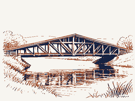
MAJOR BIBLIOGRAPHICAL REFERENCES 1957, pages 9, 13, 14. Covered Bridges on the Byways of Ohio, Oxford Printing Company, 1969, page 11.
10 GEOGRAPHICAL DATA ACREAGE OF NOMINATED PROPERTY less than one UTM REFERENCES VERBAL BOUNDARY DESCRIPTION 11 FORM PREPARED BY NAME/ TITLE Ohio Covered Bridge- Committee May 11, 1975 STREET & NUMBER CITY OR TOWN Col umbus 12 STATE HISTORIC PRESERVATION OFFICER CERTIFICATION THE EVALUATED SIGNIFICANCE OF THIS PROPERTY WITHIN THE STATE IS: LOCAL - NATIONAL - As the designated State Historic Preservation Officer for the National Historic Preservation Act of 1966 (Public Law 89-665).I hereby nominate this property for inclusion in the National Register and certify that it has been evaluated according to the *S SIGNATURE FOR NPS USE ONLY KEEPER OF THE NATIONAL REGISTER / 4309 CODE NORTHING 614-279-9576 STATE DATE EASTING COUNTY ZONE TELEPHONE ORGANIZATION ATTEST: 3155 Whitehead Road Caldwell's Atlas and Historical Sketches of Adams County, Ohio, 1880, Allen, Richard S., Covered Bridges of the Northeast, Stephan Greene Press, Miriam F.
Wood Ketcham, Bryan E., pages 26 and 112. LIST ALL STATES AND COUNTIES FOR PROPERTIES OVERLAPPING STATE OR COUNTY BOUNDARIES criteria and procedures pet forth by thg National Park Service. LUDED IN THE NATIONAL REGISTER Ohio Aoting 44.3100420 Photos - ARCHITECTURAL HISTORIAN ARCHEOLOGIST / REVIEW UNIT CHIEF MAR 1 6 1976 OTHER KEEPER HAER CONTROL Entered Send-back TECHNICAL Re-submit HISTORIAN State Accept Federal Register Entry National Register Write-up 12-12-75 12-30-75 BRANCH CHIEF OK~ 11.4.75 IN T:2106 Review 3-15-76 United States Department of the Interior National Park Service WASo No.7 Working Number /0. 31. 75. 1 93 7 4-6-26 West portal, north side, Lookinig southeast PROPERTY OF THE NATIONAL REGISTER NPS Number . 3/16/76 Form No. 10-301a (Rev.
10-74) UNITED DEPARTMENT OF THE INTERIOR FOR NPS USE ONLY NATIONAL PARK SERVICE OCT 31 1975 NATIONAL REGISTER OF HISTORIC PLACES PROPERTY PHOTOGRAPH FORM SEE INSTRUCTIONS IN HOW TO COMPLETE NATIONAL REG/STER FORMS TYPE ALL ENTRIES -- ENCLOSE WITH PHOTOGRAPH AND/OR COMMON CITY. TOWN _VICINITY OF PHOTO REFERENCE DATE OF PHOTO NEGATIVE FILED AT 3155 Whitehead Road, Columbus, Ohio 43204 DESCRIBE VIEW, DIRECTION, ETC. IF DISTRICT. GIVE BUILDING NAME & STREET LOCATION HISTORIC IDENTIFICATION COUNTY RECEIVED Adams STATE NAME March 1975 INT:2983-75 at Harshaville Harshaville Covered Bridge PHOTO NO. Ohio MAR 1 6 1976 DATE ENTERED PHOTO CREDIT Miriam F. Wood southeast. West portal, north side of bridge, looking NPS Number .. PROPERTY OF THE NATIONAL REGISTER PHOTO CREDIT - MIRIAM F WOOD Harsha ville Covered Bridge Loc. Form No. 10-301a (Rev.
10-74) UNITED STATES DEPARTMENT OF THE INTERIOR FOR NPS USE ONLY NATIONAL PARK SERVICE NATIONAL REGISTER OF HISTORIC PLACES PROPERTY PHOTOGRAPH FORM DATE ENTERED SEE INSTRUCTIONS IN HOW TO COMPLETE NATIONAL REGISTER FORMS TYPE ALL ENTRIES -IENCLOSE WITH PHOTOGRAPH AND/OR COMMON CITY, TOWN -VICINITY OF PHOTO REFERENCE PHOTO CREDIT Miriam F. Wood DATE OF PHOTO March 1975 NEGATIVE FILED AT 3155 Whitehead Road, Columbus, Ohio 43204 DESCRIBE VIEW, DIRECTION, ETC. IF DISTRICT, GIVE BUILDING NAME & STREET West portal, looking east. INT: 2983-75 COUNTY LOCATION HISTORIC IDENTIFICATION Adams STATE NAME at Harshaville PHOTO NO. Ohio Harshaville Covered Bkidge Form No.
10-301 UNITED STATES DEPARTMENT OF THE INTERIOR NATIONAL PARK SERVICE RECEIVED OCT 9 1 1975 NATIONAL REGISTER OF HISTORIC PLACES PROPERTY MAP FORM SEE INSTRUCTIONS IN HOW TO COMPLETE NATIONAL REGISTER FORMS TYPE ALL ENTRIES - ENCLOSE WITH MAP AND/OR COMMON CITY. TOWN VICINITY OF SOURCE U.S.G.S. Seaman, Ohio Quadrangle DATE 1961 TO BE INCLUDED ON ALL MAPS 1. PROPERTY BOUNDARIES 2. NORTH ARROW 3. UTM REFERENCES INT: 3464- 75 LOCATION COUNTY HISTORIC at Harshaville Adams REQUIREMENTS STATE NAME Harshaville Covered Bridge FOR NPS USE ONLY MAP REFERENCE DATE ENTERED (Rev. 10-74: Ohio SEAMAN, OHIO SEAMAN QUADRANGLE RECEIVED DEPARTMENT OF THE INTERIOR UNITED STATES DIVISION OF GEOLOGICAL SURVEY Harshaville Bridge OCT 31 1975 GEOLOGICAL SURVEY Mapped, edited, and published by the Geological Survey ROAD CLASSIFICATION MAR 1 6 1976 Clinton County Dr. Thomas H.
Smith Columbus, Ohio 43211 INT: 2980-75 Location STATE Name Lorain County Date Entered Also Notified Grafton ENTRIES IN THE NATIONAL REGISTER McArthur Harshaville Trinity Epiacopal Church Harshaville Covered Bridge Regional Director, Midwest Region State Historic Preservation Officer Lynchburg Covered Bridge 3/22/76 Lumaculate Conception Church Arbaugh Lynchiburg Interstate 7l at 17th Avenue Hon. Charles A. Mosher Hon. Clarence B. Miller Adans County Director, The Ohio Historical Society Eakin Mill Covered Bridge Clinton Coumty 2 OTHER NAMES: 3) date of entry: Harshav ille State (III)CONGRESS.
DISTRICT - FEDERAL 1 CONDITION - deteriorated Xoriginal site 2 E& SUBSTANTIALLY INTACT -3 Oruins OO NOT INTACT-O Ounexposed 5O UNKNOWN -6 Ounexcavated O NOT APPLICABLE - 9 ACCESS - No Access CAREAS OF SIGNIFICANCE : X ENGINEERING -11 - LANDSCAPE ARCH.- 15 - POLITICS / GOVT.- 21 -RECREATION -28 CLAIMS: explain 'first'O CARCHEOLOGY - prehistoric-2 -COMMERCE -6 - LAW - 16 C RELIGION- 22 C SETTLEMENT-29 -ARCHEOLOGY- historic-1 C COMMUNICATIONS-7 - EXPLORATION - 12 - LITERATURE - 17 - SCIENCE- 23 'oldest' O D AGRICULTURE -3 - CONSERVATION - 8 - HEALTH -27 - MILITARY- 18 - ARCHITECTURE-4 - ECONOMICS- 9 - INDUSTRY -13 - MUSIC - 19 E SOCIAL / CULTURAL - 30 'only' D - ART-5 - EDUCATION-10 - INVENTION - 14 - PHILOSOPHY -20 XI TRANSPORTATION - 25 2functions gdates of initial construction: (pre-CIvil War)c.1804g60 CURRENTLY: Bridge @architectural style(s): @builder/contractor: in 1804 by Theodore Burr of Oxford, NY.
reviewers initials _date. TIF ADDITIONAL SPACE NEEDED, NUMBER & PUT ON REVERSE ASSOCIATION 4/12/78 historic events: INSTITUTIONAL: ENTERTAINMENT-26 engineer: vicinity of PRIVATE ORGANIZATION EVENTS: Xaltered ADMINISTRATOR: Dexcellent NATIONAL REGISTER WRITE-UP artist: metal roof added URBAN PLANNING-31 master builder: county code: NAME as it appears on federal register: SAVED?YES 3artisan: GNPS REGION: 12SOURCE Of NOMINATION Adams CR 1 17features: - SOCIAL/HUMANITARIAN-24 OTHER (SPECIFY) major alterations: c. 1933-piersbuilt; pre-1933, sheet ©landscape architeet / garden designer: ( interior decorator: X NO Bridge ETHNIC GROUP NAMES LOCAL give role & date Xgood OWNER PRIVATE OSTATE OMUNICIPAL LOCATION street& number City/town 3-16-76 9ADAPTIVE USE YES XNO
 Block
Block