 Block
From the record
One of 12 National Register listings published here for Washington County · listed in 1975 · category: Building.
Sources: the case file at the National Archives · the National Register database, National Park Service
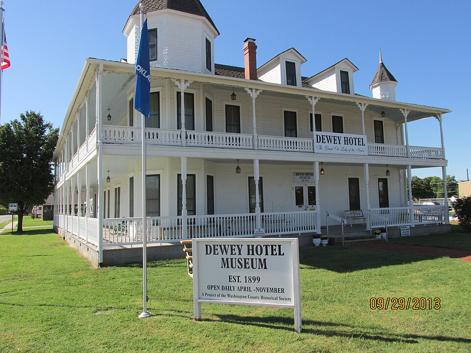
Listed on the National Register of Historic Places in 1975.
One of 12 National Register listings published here for Washington County · listed in 1975 · category: Building.
Sources: the case file at the National Archives · the National Register database, National Park Service
Regional context, not property-specific evidence. The federal wildfire occurrence database lists 19 fires within 5 miles of Dewey Hotel between 2000 and 2017, burning about 19,865 acres in total. 2 started naturally. 7 were recorded as arson. Distance is straight-line from the map coordinates, so a fire counted here may appear on a neighbouring settlement's page as well.
| Reported cause | Fires |
|---|---|
| Arson/incendiarism | 7 |
| Missing data/not specified/undetermined | 5 |
| Natural | 2 |
| Power generation/transmission/distribution | 2 |
| Debris and open burning | 2 |
| Equipment and vehicle use | 1 |
The most recent of them, most recent first, with the day each was reported and the service that recorded it.
| Date | Cause | Size | Reported by | Name on the report |
|---|---|---|---|---|
| 4 September 2012 | Natural | 1.1 acres | Osage Agency | HOPPER 1 |
| 19 September 2000 | Missing data/not specified/undetermined | 2,500 acres | Oklahoma Division of Forestry | OSAGE HILLS |
| 1 April 2011 | Missing data/not specified/undetermined | 43 acres | Osage Agency | BISHOP |
| 8 March 2008 | Arson/incendiarism | under an acre | Cherokee Nation Tribe | LATE NITE |
| 8 March 2008 | Arson/incendiarism | under an acre | Cherokee Nation Tribe | DEE-KAY |
| 28 March 2008 | Debris and open burning | 420 acres | Osage Agency | HAGEBUSH |
| 22 March 2010 | Equipment and vehicle use | under an acre | Osage Agency | MOUND |
| 2 March 2006 | Missing data/not specified/undetermined | 5.0 acres | Osage Agency | SNAKE |
Regional context, not property-specific evidence. The federal mineral resources record lists 13 workings within 5 miles of Dewey Hotel: 11 past producers, 2 producers. 2 still produce. What was taken out: Stone, Crushed/Broken, Sand and Gravel, Construction, Clay. Distance is straight-line from the map coordinates, so a quarry counted here may appear on a neighbouring settlement's page as well.
| Where | Site | Commodity | Status | Recorded |
|---|---|---|---|---|
| Unknown Sand Pit | Sand and Gravel, Construction | Past Producer | ||
| Unknown Sand Pit | Sand and Gravel, Construction | Past Producer | ||
| Unknown Sand Pit | Sand and Gravel, Construction | Past Producer | ||
| Unknown Sand Pit | Sand and Gravel, Construction | Past Producer | ||
| Unknown Shale Pit | Clay | Past Producer | ||
| Unknown Shale Pit | Clay | Past Producer | ||
| Unknown Shale Pit | Clay | Past Producer | ||
| Unknown Shale Pit | Clay | Past Producer | ||
| B&C Quarry & Plant | Stone, Crushed/Broken | Producer | ||
| No.3 Quarry & Mill | Stone, Crushed/Broken | Producer |
Regional context, not property-specific evidence. The National Weather Service names Dewey, the town this property stands in, in 74 storm reports between 1993 and 2026: 36 thunderstorm wind, 29 hail, 7 flash flood, 2 tornado. The reports record 3 injuries. Each account below is quoted exactly as the forecast office filed it, from the NOAA Storm Events Database, and each date opens the federal record of that event.
| When | Event | Place named | Harm | What the report says |
|---|---|---|---|---|
| April 2003 | Tornado (F2) | Dewey | 3 hurt, $1,700,000 | A tornado entered Washington county 5 miles northwest of Dewey and passed between Dewey and Copan before entering Nowata county 1 mile north of Wann or 6.8 miles east northeast of Copan. The tornado produced F2 damage and a half mile wide damage path at its peak. 41 homes, two businesses and 40 barns and sheds were damaged. 16 of the homes were severely damaged including two mobile homes which were completely destroyed. Three people were treated at an emergency room of a hospital in Bartlesville due to injuries received during the tornado. Two of those people were inhabitants of one of the moble homes that was destroyed. |
| April 2026 | Hail | Dewey | $25,000 | Half dollar size hail damaged homes and vehicles. |
| August 2017 | Thunderstorm Wind | Dewey | $25,000 | Strong thunderstorm wind severely damaged a large metal barn. |
| June 2007 | Flash Flood | Dewey | $25,000 | Heavy rain caused Coon Creek to flood causing parts of Highway 75 and Highway 123 to be closed. Water also flowed into the Meadowcreek subdivision and a mobile home park. |
| August 2003 | Thunderstorm Wind | Dewey | $25,000 | Thunderstorm winds estimated at 75 miles an hour caused considerable damage across the Dewey.Utility service was interupted to thousands of customers. |
| May 2000 | Flash Flood | Dewey | $25,000 | Heavy rains cause major street flooding. The heavy rains also caused 2 to 3 inch deep water to enter the Bulldogger apartments. |
| June 2025 | Thunderstorm Wind | Dewey | $15,000 | Strong thunderstorm wind blew down a large tree onto a house and privacy fence. |
| September 2014 | Thunderstorm Wind | Dewey | $10,000 | Strong thunderstorm wind blew shingles from the roofs of homes and peeled off the roof of a barn. |
| February 2012 | Thunderstorm Wind | Dewey | $10,000 | Strong thunderstorm wind overturned a travel trailer and caused extensive damage to a carport. |
| June 2008 | Thunderstorm Wind | Dewey | $10,000 | Strong thunderstorm wind gusts blew down a power pole, which fell on a house. |
| July 2003 | Thunderstorm Wind | Dewey | $10,000 | Thunderstorm winds estimated at 70 miles an hour blew power poles and power lines down. |
| August 1998 | Thunderstorm Wind | Dewey | $6,000 | A roof was removed from a mobile home. Also, several utility poles were blown down, and several tree limbs were blown down. |
| April 2010 | Thunderstorm Wind | Dewey | $5,000 | Strong thunderstorm wind damaged a barn and other outbuildings north of Dewey. |
| May 2007 | Thunderstorm Wind | Dewey | $5,000 | Thunderstorm winds estimated at 60 miles an hour blew down large tree limbs and blew a metal roof off a building. |
| April 2019 | Thunderstorm Wind | Dewey | $2,000 | Strong thunderstorm wind snapped power poles and large tree limbs. |
| June 2018 | Thunderstorm Wind | Dewey | $2,000 | Strong thunderstorm wind snapped two power poles. |
| May 1999 | Thunderstorm Wind | Dewey | $2,000 | Power lines were blown down in Dewey. |
| June 1997 | Thunderstorm Wind | Dewey | $2,000 | no account filed |
| March 2017 | Thunderstorm Wind | Dewey | $1,000 | Strong thunderstorm wind blew down a tree and several sections of a privacy fence. |
| August 1998 | Thunderstorm Wind | Dewey | $500 | Trees were blown down near Dewey. |
| August 1997 | Thunderstorm Wind | Dewey | $500 | no account filed |
| September 1998 | Thunderstorm Wind | Dewey | $300 | Several trees were blown down just west of Dewey. |
| May 2000 | Thunderstorm Wind | Dewey | $100 | Thunderstorm winds blew a tree down. |
| April 1999 | Thunderstorm Wind | Dewey | $100 | Several tree limbs were blown down. |
| September 1996 | Thunderstorm Wind | Dewey | $100 | no account filed |
| September 1996 | Thunderstorm Wind | Dewey | $100 | no account filed |
| April 2020 | Thunderstorm Wind | Dewey | - | Thunderstorm wind gusts were estimated to 70 mph. |
| May 2019 | Flash Flood | Dewey | - | Portions of Highway 60 east of Bartlesville, between Bison Road and CR 4015, were flooded and closed. |
| May 2019 | Flash Flood | Dewey | - | Lakeshore Mobile Home park was evacuated due to flooding of Coon Creek. |
| May 2017 | Flash Flood | Dewey | - | Several roads were flooded in and around Dewey. |
| August 2017 | Thunderstorm Wind | Dewey | - | Strong thunderstorm wind blew down trees across Highway 60 near the N 4000 Road. |
| October 2017 | Thunderstorm Wind | Dewey | - | Strong thunderstorm wind gusts were estimated to 60 mph. |
| August 2015 | Flash Flood | Dewey | - | Portions of County Road 1400 were flooded. |
| May 2012 | Thunderstorm Wind | Dewey | - | Strong thunderstorm wind blew down large trees. |
| April 2011 | Tornado (EF1) | Dewey | - | This is the first of two segments of this tornado. In Washington County, this tornado uprooted several trees. Maximum estimated wind in the tornado based on this damage was 95 mph. The tornado continued into Nowata County, Oklahoma. |
| April 2010 | Thunderstorm Wind | Dewey | - | Strong thunderstorm wind blew down large tree limbs. |
| April 2010 | Hail | Dewey | - | A storm chaser with KJRH reported quarter size hail. |
| June 2010 | Thunderstorm Wind | Dewey | - | Strong thunderstorm wind blew down several large trees. |
| May 2009 | Thunderstorm Wind | Dewey | - | Thunderstorm winds estimated at 70 miles an hour blew a tree down. The tree blocked a road. |
| July 2005 | Thunderstorm Wind | Dewey | - | Thunderstorm winds estimated at 60 miles an hour blew down large tree limbs. |
| July 2005 | Thunderstorm Wind | Dewey | - | Thunderstorm winds estimated at 60 miles an hour blew down large tree limbs. |
| August 2005 | Thunderstorm Wind | Dewey | - | Strong thunderstorm wind blew down large tree limbs. |
| July 2003 | Thunderstorm Wind | Dewey | - | Thunderstorm winds estimated at 60 miles an hour blew down a large tree limb. |
| May 2002 | Flash Flood | Dewey | - | Thunderstorms produced heavy rain over Washington county during the late evening hours. Bartlesville received 2.18 inches of rain. This rainfall was enough that it caused some city streets to become impassable in nearby Dewey. |
| July 1994 | Hail | Dewey | - | An isolated severe thunderstorm developed in Washington County of northeast Oklahoma during the early morning of July 17th. Dime-size hail fell just north of Dewey, and strong thunderstorm winds blew out a window at an Arby's Restaurant on the northeast side of Bartlesville. |
| May 2025 | Hail | Dewey | - | no account filed |
| February 2024 | Hail | Dewey | - | no account filed |
| July 2023 | Hail | Dewey | - | no account filed |
| April 2020 | Hail | Dewey | - | no account filed |
| April 2020 | Hail | Dewey | - | no account filed |
| April 2020 | Hail | Dewey | - | no account filed |
| April 2016 | Hail | Dewey | - | no account filed |
| April 2016 | Hail | Dewey | - | no account filed |
| August 2015 | Hail | Dewey | - | no account filed |
| November 2015 | Hail | Dewey | - | no account filed |
| March 2011 | Hail | Dewey | - | no account filed |
| April 2011 | Hail | Dewey | - | no account filed |
| April 2010 | Hail | Dewey | - | no account filed |
| May 2010 | Hail | Dewey | - | no account filed |
| February 2009 | Hail | Dewey | - | no account filed |
No historic map-sheet match is published for this property yet. That does not mean no map exists. This record needs a coordinate-quality review before it can be joined to a sheet boundary. Browse the county's mapped places while that work is pending.
Other National Register properties close enough to walk or drive between, ordered by distance from this one. Both positions come from the same geocoding pass that matched these properties to their map sheets.
| Photograph | Property | Distance | Listed |
|---|---|---|---|
 | C.A. Comer House | 0.5 miles | 2015 |
 | Nellie Johnstone No. 1 | 3.5 miles | 1972 |
| First United Methodist Church | 3.6 miles | 2020 | |
 | Washington County Memorial Hospital | 3.8 miles | 2014 |
 | Old Washington County Courthouse | 3.9 miles | 1981 |
| Bartlesville Downtown Historic District | 4.0 miles | 1991 |
| National Archives record | The nomination case file for reference 75001578 in Record Group 79. |
| Washington County | All 12 listed properties in this county. |