 Block
From the record
One of 19 National Register listings published here for Rogers County · listed in 1982 · category: Building · built in 1920.
Sources: the case file at the National Archives · the National Register database, National Park Service
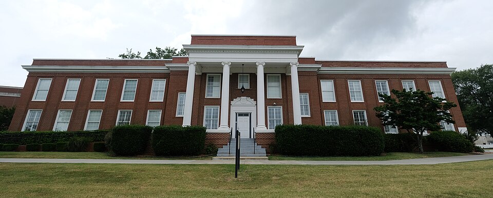
Built in 1920. Listed on the National Register of Historic Places in 1982.
One of 19 National Register listings published here for Rogers County · listed in 1982 · category: Building · built in 1920.
Sources: the case file at the National Archives · the National Register database, National Park Service
Regional context, not property-specific evidence. The federal mineral resources record lists 27 workings within 5 miles of Maurice Meyer Barracks: 27 past producers. None of them still produces. What was taken out: Sand and Gravel, Construction, Stone, Crushed/Broken. Distance is straight-line from the map coordinates, so a quarry counted here may appear on a neighbouring settlement's page as well.
| Where | Site | Commodity | Status | Recorded |
|---|---|---|---|---|
| Unknown Limestone Pit | Stone, Crushed/Broken | Past Producer | ||
| Unknown Limestone Pit | Stone, Crushed/Broken | Past Producer | ||
| Unknown Gravel Pit | Sand and Gravel, Construction | Past Producer | ||
| Unknown Gravel Pit | Sand and Gravel, Construction | Past Producer | ||
| Unknown Gravel Pit | Sand and Gravel, Construction | Past Producer | ||
| Unknown Gravel Pit | Sand and Gravel, Construction | Past Producer | ||
| Unknown Gravel Pit | Sand and Gravel, Construction | Past Producer | ||
| Unknown Gravel Pit | Sand and Gravel, Construction | Past Producer | ||
| Unknown Gravel Pit | Sand and Gravel, Construction | Past Producer | ||
| Unknown Gravel Pit | Sand and Gravel, Construction | Past Producer |
Regional context, not property-specific evidence. The National Weather Service names Claremore, the town this property stands in, in 132 storm reports between 1993 and 2025: 58 thunderstorm wind, 53 hail, 16 flash flood, 3 tornado. The reports record 2 deaths. Each account below is quoted exactly as the forecast office filed it, from the NOAA Storm Events Database, and each date opens the federal record of that event.
| When | Event | Place named | Harm | What the report says |
|---|---|---|---|---|
| May 2015 | Flash Flood | Claremore | 1 killed | Firefighter drowns performing water rescue just west of town on highway 20. |
| July 1997 | Lightning | Claremore | 1 killed | A 42 year old man was struck and killed by lightning when he went outdoors to roll up his car windows. |
| March 2016 | Tornado (EF2) | Claremore | $1,000,000 | This tornado damaged numerous homes east of Highway 66 and west of I-44. Some of the worst damage in the path occurred in a housing area near Highway 88 where several homes received severe damage to their roofs and wall structures. Several vehicles were rolled. The tornado moved east along the E 500 Road where trees were snapped or uprooted, homes were damaged, and barns were destroyed. The tornado then moved east-northeast toward Will Rogers Downs on Highway 20, where it turned sharply to the northeast and dissipated after damaging several large barns. Based on this damage, maximum estimated wind in the tornado was 120 to 130 mph. |
| April 2008 | Heavy Rain | Claremore | $1,000,000 | Heavy rain caused a landslide on a hill along Highway 20 near Keetonville. The landslide did severe damage to the road. |
| June 2012 | Flash Flood | Claremore | $300,000 | Locally heavy rain resulted in over three feet of water flooding streets in town. A few homes on the southwest side of town were damaged by the flood water. A road south of town near Concord Heights was washed out. |
| March 2020 | Hail | Claremore | $250,000 | Large hail damaged vehicles, and the roofs of homes and businesses. |
| March 2020 | Hail | Claremore | $150,000 | Large hail damaged vehicles, and the roofs of homes and businesses. |
| November 1999 | Tornado (F1) | Claremore | $150,000 | A tornado touched down 3 miles southeast of Claremore and traveled about 3 miles northeast to 1/2 mile northeast of Will Rogers Downs or 4 miles east of Claremore. One mobile home was destroyed and another mobile home was blown off its foundation. A house under construction was flattened and three horse barns were heavily damaged. |
| May 2008 | Thunderstorm Wind | Claremore | $25,000 | Thunderstorm winds estimated at 80 miles hour did structural damage to buildings and to a mobile home. Power lines were also blown down. |
| March 2016 | Hail | Claremore | $25,000 | no account filed |
| April 2006 | Hail | Claremore | $20,000 | Tennis ball size hail fell four miles northeast of Owasso or at 161st East Avenue and 96th Street North. |
| August 2016 | Thunderstorm Wind | Claremore | $10,000 | Strong thunderstorm wind damaged the roof of a business, snapped numerous large tree limbs, and snapped a power pole. |
| September 2012 | Thunderstorm Wind | Claremore | $10,000 | Strong thunderstorm wind uprooted several trees and damaged the roofs of homes. |
| May 2011 | Thunderstorm Wind | Claremore | $10,000 | Several trees were uprooted, large limbs were snapped, and the roofs of several homes were damaged. |
| May 2011 | Thunderstorm Wind | Claremore | $10,000 | Several barns were damaged by strong thunderstorm winds. |
| April 2011 | Thunderstorm Wind | Claremore | $10,000 | Strong thunderstorm wind blew down several trees and damaged roofs at Rogers State University. |
| June 2008 | Thunderstorm Wind | Claremore | $10,000 | Thunderstorm winds estimated at 80 miles an hour damaged a metal fire station building. Power poles and trees were also blown down. |
| August 1999 | Tornado (F1) | Claremore | $10,000 | A "rope" tornado caused roof damage to a barn, blew the roof off a mobile home and caused other damage 5 miles northeast of Owasso. |
| May 2017 | Hail | Claremore | $10,000 | no account filed |
| November 1996 | Thunderstorm Wind | Claremore | $10,000 | no account filed |
| August 1998 | Thunderstorm Wind | Claremore | $9,000 | A 50-foot cattle trailer was turned completely over. Large elm trees were twisted and one was uprooted. There was structural damage to the aluminum frame and door locks on a building at the A-Bar Ranch east of the Claremore Municipal Airport. Winds were estimated at 70 miles an hour by the general public. |
| June 2023 | Thunderstorm Wind | Claremore | $5,000 | Strong thunderstorm wind removed the majority of shingles from the west side of a roof, blew down a stop sign, and blew down a maple tree. |
| June 2022 | Thunderstorm Wind | Claremore | $5,000 | Strong thunderstorm wind blew down a tree onto a car. |
| July 2020 | Thunderstorm Wind | Claremore | $5,000 | Strong thunderstorm wind blew down a large sign. |
| May 2017 | Thunderstorm Wind | Claremore | $5,000 | Strong thunderstorm wind uprooted a tree, snapped numerous large tree limbs, and snapped power poles along Blue Starr Drive and Clubhouse Road on the northwest side of Claremore. |
| May 2010 | Thunderstorm Wind | Claremore | $5,000 | Strong thunderstorm wind blew down trees and power lines. |
| June 2009 | Thunderstorm Wind | Claremore | $5,000 | Thunderstorm winds measured at 80 miles an hour blew down trees and power lines. |
| August 2006 | Thunderstorm Wind | Claremore | $5,000 | Thunderstorm winds estimated at 70 miles an hour blew down a tree. The tree fell on a house. |
| June 2004 | Thunderstorm Wind | Claremore | $5,000 | Thunderstorm winds estimated at 60 miles an hour blew down large tree limbs and power lines. As many as 8,000 Claremore residents were without power at the peak of the outage. |
| July 2002 | Thunderstorm Wind | Claremore | $5,000 | Thunderstorm winds estimated at 70 miles an hour blew trees and power lines down. |
| October 2004 | Thunderstorm Wind | Claremore | $3,000 | Thunderstorm winds blew down power lines and trees. |
| June 2023 | Thunderstorm Wind | Claremore | $2,000 | Strong thunderstorm wind snapped numerous large tree limbs, and blew down a portion of a privacy fence. |
| July 2018 | Thunderstorm Wind | Claremore | $2,000 | Strong thunderstorm wind snapped power poles. |
| April 2014 | Thunderstorm Wind | Claremore | $2,000 | Strong thunderstorm wind blew the roof off of a shed. |
| November 1998 | Thunderstorm Wind | Claremore | $1,500 | Several trees were blown down, and an awning was blown off of a business. A newspaper clipping showed a picture of a large oak tree that barely missed falling onto a home on Crestview Drive east of Claremore. |
| May 1999 | Thunderstorm Wind | Claremore | $500 | Several trees were blown down in Claremore. |
| November 1996 | Thunderstorm Wind | Claremore | $500 | no account filed |
| April 1999 | Thunderstorm Wind | Claremore | $300 | A door was blown off of a house. Two downtown buildings in Claremore had their frontages damaged. One of these was the Chamber of Commerce which had two concrete veneer blocks from the roofline blown down. |
| August 1997 | Thunderstorm Wind | Claremore | $100 | no account filed |
| August 1997 | Thunderstorm Wind | Claremore | $100 | no account filed |
| June 2025 | Thunderstorm Wind | Claremore | - | Thunderstorm wind gusts were estimated to 60 mph on Highway 88 and the E 470 Road. |
| June 2023 | Thunderstorm Wind | Claremore | - | Strong thunderstorm wind blew down several large hackberry and hickory trees. |
| August 2023 | Thunderstorm Wind | Claremore | - | Strong thunderstorm wind snapped large tree limbs. |
| May 2019 | Flash Flood | Claremore | - | Numerous roads in and around the City of Claremore were flooded and closed. |
| May 2019 | Flash Flood | Claremore | - | Numerous roads were flooded and closed in and around Claremore. |
| June 2019 | Flash Flood | Claremore | - | Numerous roads in the City of Claremore were flooded. Road closures included Lynn Riggs Boulevard on the west side of the courthouse, Archer between Highway 20 and Dupont, and Lowry Road at the low water bridge. |
| June 2019 | Flash Flood | Claremore | - | Portions of several roads on the west side of Claremore were flooded and closed. |
| June 2019 | Flash Flood | Claremore | - | Several roads were flooded and closed in and around Claremore. |
| August 2019 | Thunderstorm Wind | Claremore | - | Strong thunderstorm wind blew down trees at the Heritage Hills Golf Course, on the west side of Claremore. |
| August 2018 | Thunderstorm Wind | Claremore | - | Strong thunderstorm wind snapped large tree limbs. |
| May 2017 | Thunderstorm Wind | Claremore | - | Thunderstorm wind gusts were estimated to near 60 mph. |
| June 2017 | Thunderstorm Wind | Claremore | - | Strong thunderstorm wind snapped large tree limbs. |
| May 2015 | Flash Flood | Claremore | - | Several roads were flooded in and around town. |
| May 2015 | Flash Flood | Claremore | - | Portions of Highway 20 on the east side of Claremore were flooded. |
| June 2014 | Thunderstorm Wind | Claremore | - | A storm chaser measured thunderstorm wind gusts to 63 mph. |
| July 2013 | Thunderstorm Wind | Claremore | - | Strong thunderstorm wind snapped several large tree limbs at the Heritage Hills Golf Course. |
| September 2012 | Thunderstorm Wind | Claremore | - | A large tree was uprooted by strong thunderstorm wind. |
| April 2011 | Thunderstorm Wind | Claremore | - | Thunderstorm wind gusts up to 65 mph were estimated about 1 mile north of Rogers State University. |
| May 2011 | Thunderstorm Wind | Claremore | - | Thunderstorm wind gusts of 60 mph were measured by the AWOS unit at the Claremore Regional Airport. |
| April 2010 | Thunderstorm Wind | Claremore | - | An amateur radio operator measured 61 mile per hour thunderstorm wind gusts. |
No historic map-sheet match is published for this property yet. That does not mean no map exists. This record needs a coordinate-quality review before it can be joined to a sheet boundary. Browse the county's mapped places while that work is pending.
Other National Register properties close enough to walk or drive between, ordered by distance from this one. Both positions come from the same geocoding pass that matched these properties to their map sheets.
| Photograph | Property | Distance | Listed |
|---|---|---|---|
| Eastern University Preparatory School | under 500 feet | 1982 | |
 | Claremore Auto Dealership | 1.1 miles | 1995 |
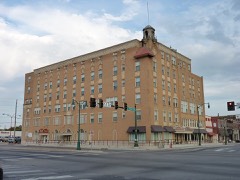 | Will Rogers Hotel | 1.2 miles | 1994 |
| Downtown Claremore Historic District | 1.3 miles | 2016 | |
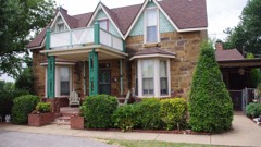 | Hanes Home | 1.4 miles | 1982 |
| Will Rogers Memorial Library | 1.4 miles | 2023 |
| National Archives record | The nomination case file for reference 82003698 in Record Group 79. |
| Rogers County | All 19 listed properties in this county. |