 Block
Block
La Rue, Ohio
10 topographic sheets cover this place, the earliest surveyed in 1915 and the latest in 1986. It stands in Montgomery Township. It lies in ZIP code area 43332. The Survey maps it on the La Rue quadrangle. 676 people lived here at the 2020 count. It stands 925 feet above sea level.
Population over time
2 figuresLa Rue fell from 747 to 676 between 2010 and 2020. These are the recorded population figures Wikidata holds for this place, reached through the Geographic Names Information System number this page is keyed on rather than by name, so they belong to this place and not to another of the same name. Most are census counts, but not all are: an early figure may be a founding or settlement estimate. The change column is computed, and is left blank where more than 20 years separate a figure from the one before it, because a gap that long is not a change between two counts.
| Year | People | Change |
|---|---|---|
| 2010 | 747 | |
| 2020 | 676 | -71 (-10%) |
Then and now
1915 to 1986The same ground, surveyed 71 years apart. Drag the handle to wipe between them. Both sheets are United States Geological Survey originals; neither has been altered.

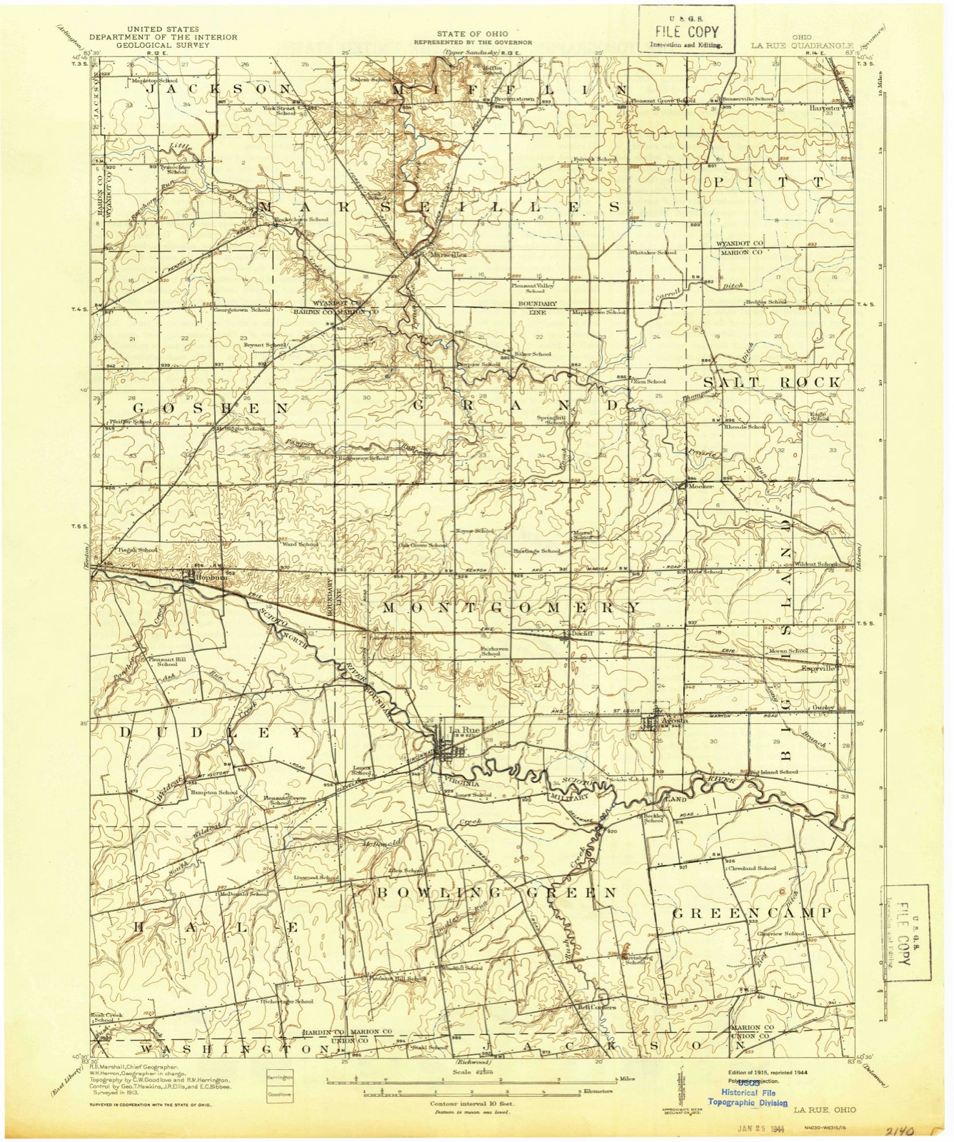
Topographic sheets covering this place
10 sheetsMatched by testing this settlement's coordinate against the published boundary of every sheet in the United States Geological Survey's historical collection. Each opens the scanned sheet at the Survey.
- 1915 USGS La Rue quadrangle1:62500
- 1950 USGS Marion quadrangle1:250000
- 1961 USGS La Rue quadrangle1:24000
- 1961 USGS La Rue quadrangle1:24000
- 1962 USGS Marion quadrangle1:250000
- 1966 USGS Marion quadrangle1:250000
- 1966 USGS Marion quadrangle1:250000
- 1966 USGS Marion quadrangle1:250000
- 1986 USGS Marion quadrangle1:100000
- 1986 USGS Marion quadrangle1:100000







Specimens collected nearby
12 of 110 shownMuseums hold 110 specimens collected within 10 miles of La Rue between 1929 and 1964: 109 Animalia, 1 Fungi. 12 distinct Species records are shown. Collected by J A PETERS AND PHILLIP CLARK, John W. Peacock, King Lawrence J. and others. Each is a physical object with a catalogue number, and each entry opens the museum's record. This is what was collected and kept, not a survey of what lives here - nothing can be concluded from a species being absent.
| Image | Species | Year | Collected by | Where, as recorded |
|---|---|---|---|---|
 | Campostoma anomalum anomalum | 1929 | Trautman, M. B. (Milton Bernard) & Foster, R. (Robert) | McDonald Creek, within Bowling Green township, near La Rue, Bowling Green township |
 | Ericymba buccata Cope, 1865 | 1929 | Trautman, M. B. (Milton Bernard) & Foster, R. (Robert) | Tymochtee Creek, within Grand township, near Marseilles, Grand township |
 | Erimyzon oblongus claviformis (Girard, 1856) | 1929 | Trautman, M. B. (Milton Bernard) & Foster, R. (Robert) | Pawpaw Run, within Grand township, near Marseilles, Grand township |
 | Etheostoma nigrum Rafinesque, 1820 | 1929 | Trautman, M. B. (Milton Bernard) & Foster, R. (Robert) | McDonald Creek, within Bowling Green township, near La Rue, Bowling Green township |
 | Etheostoma spectabile (Agassiz, 1854) | 1929 | Trautman, M. B. (Milton Bernard) & Foster, R. (Robert) | McDonald Creek, within Bowling Green township, near La Rue, Bowling Green township |
 | Fundulus notatus (Rafinesque, 1820) | 1929 | Trautman, M. B. (Milton Bernard) & Foster, R. (Robert) | McDonald Creek, within Bowling Green township, near La Rue, Bowling Green township |
 | Ictalurus melas (Linnaeus, 1758) | 1929 | Trautman, M. B. (Milton Bernard) & Foster, R. (Robert) | Pawpaw Run, within Grand township, near Marseilles, Grand township |
 | Lepomis cyanellus Rafinesque, 1819 | 1929 | Trautman, M. B. (Milton Bernard) & Foster, R. (Robert) | Tymochtee Creek, within Grand township, near Marseilles, Grand township |
 | Luxilus cornutus (Mitchill, 1817) | 1929 | MB Trautman | Tymochtee Creek, at Marseilles, Marseilles Twnp |
 | Notropis umbratilis (Girard, 1856) | 1929 | Trautman, M. B. (Milton Bernard) & Foster, R. (Robert) | McDonald Creek, within Bowling Green township, near La Rue, Bowling Green township |
 | Phenacobius mirabilis (Girard, 1856) | 1929 | Trautman, M. B. (Milton Bernard) & Foster, R. (Robert) | McDonald Creek, within Bowling Green township, near La Rue, Bowling Green township |
 | Pimephales notatus (Rafinesque, 1820) | 1929 | Trautman, M. B. (Milton Bernard) & Foster, R. (Robert) | Pawpaw Run, within Grand township, near Marseilles, Grand township |
All 110 specimens within 10 miles, at the Global Biodiversity Information Facility.
Storms nearby
27 since 1997The National Weather Service names La Rue in 27 storm reports between 1997 and 2019: 17 thunderstorm wind, 5 flood, 4 hail, 1 funnel cloud. No death or injury is recorded in these reports. Each account below is quoted exactly as the forecast office filed it, from the NOAA Storm Events Database, and each date opens the federal record of that event.
| When | Event | Place named | Harm | What the report says |
|---|---|---|---|---|
| December 2013 | Flood | La Rue | $500,000 | The Scioto River at La Rue in Marion County Ohio experienced it's worst flood in 50 years (03/05/63 15.95 feet) when it crested at a stage of 14.18 feet on December 22nd. This major flood surpassed the more recent floods February 28, 2011 by only 0.09 feet. The Scioto River will flood the outskirts of town before reaching the city limits. When the river comes out of banks, it quickly fills up the low lying town. The Kiwanis Village retirement community, an apartment complex for seniors inundated as much as 2 feet in some units, and reached the roofs of cars left in the parking lot. 100 people had to be evacuated. Access in and out of town were cut off by flood waters. The floods were the result of heavy rain tha fell on December 21st over saturated ground. Any snow had long since melted and the ground was not frozen. The basin average rainfall was around 3 inches. |
| June 2011 | Thunderstorm Wind | La Rue | $300,000 | A supercell thunderstorm produced a significant downburst which damaged and destroyed several large grain storage silos in the area. A garage roof was blown off and shingles were blown off several structures. A large barn was blown off its foundation. Large tree limbs were downed as well as four power poles. |
| December 2013 | Thunderstorm Wind | La Rue | $100,000 | A line of thunderstorms caused considerable damage in Marion County. A silo was damaged near LaRue and a semi truck was blown over near Marion. Many trees and large limbs were also downed across the area. |
| November 2011 | Hail | La Rue | $50,000 | Hail the size of golf balls was observed. Several vehicles were damaged by the hail. |
| June 2011 | Thunderstorm Wind | La Rue | $50,000 | Thunderstorm winds downed several large trees. Numerous power poles were downed as as well. |
| April 2001 | Thunderstorm Wind | La Rue | $35,000 | Thunderstorm winds downed several trees and large tree limbs. A car was damaged and a mobile home had some skirting torn off. Two small sheds were also blown down. |
| August 2009 | Thunderstorm Wind | La Rue | $20,000 | Utility poles, power lines, and a tree was reported down throughout western portions of the county. |
| September 2003 | Thunderstorm Wind | La Rue | $15,000 | Thunderstorm winds downed three power poles near La Rue. |
| October 2001 | Thunderstorm Wind | La Rue | $15,000 | Thunderstorm winds downed several trees approximately five miles north of La Rue near the intersection of State Routes 37 and 309. |
| May 2012 | Thunderstorm Wind | La Rue | $10,000 | Thunderstorm winds downed a few trees. |
| July 2018 | Thunderstorm Wind | La Rue | $5,000 | Thunderstorm winds downed trees in southwest Marion County and also in the City of Marion. |
| August 2006 | Thunderstorm Wind | La Rue | $5,000 | Three trees were reported down. |
| July 2003 | Thunderstorm Wind | La Rue | $5,000 | Thunderstorm winds downed two large trees. |
| May 2013 | Thunderstorm Wind | La Rue | $3,000 | A trained spotter measured a 65 mph thunderstorm wind gust. Several large tree limbs were snapped. |
| June 2003 | Thunderstorm Wind | La Rue | $2,000 | Thunderstorm winds downed several large tree limbs five miles north of La Rue. A wheat field in the same area was flattened. |
| July 2010 | Thunderstorm Wind | La Rue | $1,000 | Thunderstorm winds downed one large tree. |
| January 2019 | Flood | La Rue | - | The Scioto River at La Rue crested at 13.04 feet on the night of the 24th. When the Scioto exceeds 13.00 feet the river waters approach the town of La Rue. No flood damage losses has been reported in this area on this event. Route 37 and parts of Vine Street were flooded. |
| November 2018 | Flood | La Rue | - | The Scioto River at LaRue reached a stage of 13.87 feet on the afternoon of November 2nd. Major flood stage is 14.0 feet, just inches away from the observed river levels. Flood mitigation projects in the region have worked to address the impacts from flood events of this category which resulted in no monetary damages. The river did surpass its banks and flood into the town roads for 20.5 hours on the 2nd. For most of that time flood waters exceeded 5 or more inches of 100+ feet in length across the primary throughway in town. Similar flood levels events of 2011 and 2013 resulted in major property losses of up to 1 million dollars in each year. Most of those flood loss dollars were in the area of the recently installed improvements and were not damaged in this event. No flood damage losses has been reported in this area on this event though waters were inches away from inundated businesses and a nursing home. |
| June 2011 | Hail | La Rue | - | Thunderstorms produced quarter size hail. |
| June 2011 | Thunderstorm Wind | La Rue | - | Thunderstorm winds downed several tree limbs. |
| June 2006 | Flood | La Rue | - | The Scioto River at LaRue flooded from the early morning hours of the 3rd through the early morning hours of the 4th. Flood stage is 11.0 feet. The river crested during the afternoon on the 3rd. No injuries or signficant damage was reported during this event. |
| June 2006 | Hail | La Rue | - | Penny size hail was observed. |
| July 2006 | Flood | La Rue | - | During the early morning hours of July 13th, the Scioto River at LaRue went into flood. Flood stage for the Scioto River at LaRue is 11 feet. The river crested at 12.9 feet during the evening of the 13th. However, due to the widespread heavy rainfall across the area, the river remained in flood through the 14th and finally went below flood stage during the early morning hours of the 15th. |
| May 2005 | Thunderstorm Wind | La Rue | - | A 58 mph wind gust was measured by a trained spotter located just south of La Rue |
| August 2001 | Funnel Cloud | La Rue | - | Trained spotters reported a funnel cloud. The funnel cloud quickly dissipated and caused no damage. |
| May 1998 | Hail | La Rue | - | no account filed |
| July 1997 | Thunderstorm Wind | La Rue | - | no account filed |
Nearest settlements
The eight closest, with where each one stands in the county. Distances are straight-line, computed from the Geographic Names Information System coordinates.
| Map | Place | Distance | Sheets |
|---|---|---|---|
| Winnemac (historical) | 0.3 miles | 10 | |
| Holmesville (historical) | 2.7 miles | 11 | |
| DeCliff | 3.1 miles | 11 | |
| New Bloomington | 3.6 miles | 11 | |
| Meeker | 6.2 miles | 11 | |
| Gurley (historical) | 6.9 miles | 11 | |
| Espyville | 7.0 miles | 11 | |
| Longville (historical) | 8.9 miles | 13 |
Elsewhere
Matched on this settlement's Geographic Names Information System number rather than its name, so it cannot be a different place of the same name in another state.
| Wikipedia article on La Rue | An encyclopaedic summary. Its text is share-alike, so it is linked here rather than copied. |
| Wikidata item Q2413269 | The structured record the population and elevation above come from. Public domain (CC0). |
Provenance
This settlement is recorded in the Geographic Names Information System as feature 1058187. The sheet list is computed by point-in-boundary test against the United States Geological Survey's historical topographic inventory. Both are works of the United States government and carry no copyright under 17 U.S.C. 105.
Specimens. Global Biodiversity Information Facility (GBIF), https://www.gbif.org/. Only records licensed CC0 or CC BY are used. Records licensed CC BY-NC are excluded because this site carries advertising. Images are checked individually and any whose licence is non-commercial, no-derivatives or unreadable is refused.
Storms. NOAA National Centers for Environmental Information, Storm Events Database https://www.ncei.noaa.gov/stormevents/ A work of the United States government, no copyright under 17 U.S.C. 105. Narratives are quoted verbatim from the National Weather Service report and are not edited or summarised.