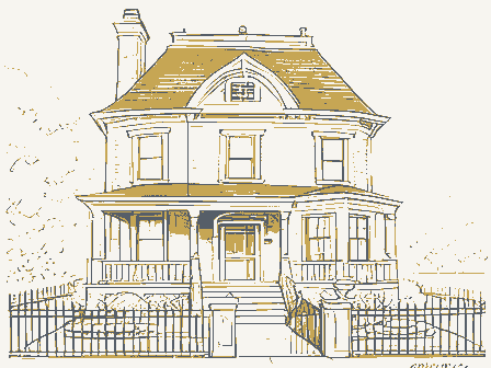
Listed on the National Register of Historic Places in
1982. A historic map-sheet match is not published yet. The record needs a coordinate-quality review before it can be joined to a sheet boundary.
From the record
one of 18 National Register listings in Wayne County · listed in 1982 · category: Building.
National Register reference number.13000897- the number the National Park Service assigned this property when it was listed, and the key its nomination file is catalogued under at the National Archives.
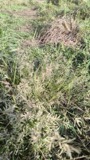
Specimens collected near this property
12 of 57 shown
Regional context, not property-specific
evidence. Museums hold 57 specimens
collected within 10 miles of Gish Farmhouses between 1896 and
1970: 31 Animalia, 21 Plantae, 3 Fungi, 2 Chromista. 12 distinct Species records are shown.
Collected by A C ALLEN, Bruce, J. A., Cusick, A.W. and others. Each is a
physical object with a catalogue
number, and each entry opens the museum's record. This is what was
collected and kept, not a survey of what lives here - nothing can be
concluded from a species being absent.
Regional context, not property-specific
evidence. The federal mineral resources record lists
1 working within 5 miles of Gish Farmhouses: 1 plant.
All of them still produce. What was taken out: Sand and Gravel, Construction. Distance is straight-line from the
map coordinates, so a quarry counted here may appear on a neighbouring
settlement's page as well.
Regional context, not property-specific
evidence. The National Weather Service names
Rittman, the town this property stands in, in 28 storm reports between 1995 and 2026: 13 hail, 11 thunderstorm wind, 3 flash flood, 1 tornado.
No death or injury is recorded in these reports. Each account below is quoted exactly as the forecast office
filed it, from the NOAA Storm Events Database, and each date
opens the federal record of that event.
State of Emergency declared in Rittman due to flooding on June 17. Flash flooding stranded cars and closed the citys only grocery store in Rittman. Around 5 a.m. the Landis Ditch, which runs past the Rittman Shopping Center, breached its banks and quickly flooded the above streets and flooded the businesses in the plaza including the Rittman IGA. The Chippewa Creek also exceeded its banks at a 100 year level, about 8 feet above normal. Water was approximately 3.5 feet deep on Whitman Road between Porr and the railroad tracks. Numerous vehicles stalled in flood waters and needed water rescues. Most flood damages occurred along Main Street and along Industrial and Ohio avenues by Marathon, with the worst areas landing around Seneca and State streets. A couple families were cut off from their homes as a result of the flooding. Flood waters receded by 1130 am.
Heavy rain fell across the area during the morning of the 20th and caused flash flooding across primarily northeast portions of the county. Some homes had water flowing into the basements, and a strip mall in the area was also flooded. Enough homes in the area were flooded out that a shelter was opened in Rittman for the flood victims. Rainfall amounts varied significantly across the northern half of Wayne County for this event. While the Wayne County Airport picked up only 0.86 inches between 4 pm Sunday and 4 pm Monday, rainfall reports just north of Rittman into southern Medina County indicate that between 2.0 and 4.0 inches of rain fell there during that same time period.
The tornado touched down on the southeast corner of the town of Rittman then traveled east toward Hatfield Road and Ohio 94 where it flattened an apple orchard. Several buildings were also damaged in the vicinity of the orchard including a small concrete block building which was completely destroyed. The roofs of several other buildings were severely damaged. From the site of the orchard, the tornado traveled east and knocked down many trees before finally dissipating near Doylestown. Eye witness reports and damage surveys indicate that the tornado was slightly aloft during a good part of its life cycle.
Thunderstorm winds downed several trees west of Rittman on Doylestown Road. A funnel cloud was observed in the area but no evidence of a touchdown was found.
No historic map-sheet match is published
for this property yet. That does not mean no map exists. This record needs
a coordinate-quality review before it can be joined to a sheet boundary.
Browse the county's mapped places while that work is
pending.
From the nomination file
4,588 words on record
When this property was proposed for the
National Register, someone wrote the case for it: what the building is,
and why it matters. That document is a federal record in the public domain.
It is quoted below word for word, never summarised. The text was read off the scanned case file by machine, so the
occasional stray character is the recogniser's and the 1970s
typewriter's.
Description of the property
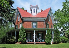
thousand people, these buildings enjoy a picturesque hilly rural site. The buildings with returns at the sides, and small rectangular windows and doors plus a shallow pitched building is surmounted by a slate roof. The original slate were recently relaid and the wall areas. The basement is a modern feature, with restrooms, and features a grade level and brick detailing, plus an intricate plan are present. second floor which has over a half dozen bedrooms. A large rear stairway goes from the first to the third floors. The interior furnishings, wallpaper, bathroom fixtures and To the south and west of the John Gish House are two large brick barns which were used in the tobacco operation, plus some smaller wood sheds.
These buildings are simple X good The John Gish House is an unusually large and ornate Queen Anne style residence con- having been removed several years ago in anticipation of the building's demolition.All entrance in the rear. roof flashing repaired.Inside,the house feature3 a number of small roomis.Two parlors The house enjoys a picturesque setting atop a small hill in Gish Areas of SignificanceCheck and justify below - archeology-historic _ conservation . law - social/ _ invention - other (specify) Statement of
Statement of significance
(in one paragraph) the height of its operations in the mid to late nineteenth centuries, enabled its owners the raising of tobacco here and encouraged other farmers to grow this crop. Gish operated but particularly in the Ohio region. These two farmhouses with their outbuildings, are the last physical vestige of this important industry. In addition, the earlier building is a fine example of Greek Revival Style architecture and the later residence is an and began preparations for moving westward to Ohio in 1830. Gish purchased 116 acres of a suitable house for his large family in 1859 which his oldest son, Abraham, a carpenter by when milder southern-grown tobaccos became popular. A descendant of Jacob Gish, Evangeline point where it was to be razed.
To save the building, a local historical society was underway and the building will become a museum and public meeting facility. commerce 1400-1499 1700-1799 transportation communications engineering industry humanitarian science theater music prehistoric military sculpture in excellent condition. literature 8.
Significance _education 1900- an extensive tobacco operation which produced cigars for shipment all over the country, - politics/government X1800-1899 unusually large and rare example of brick Queen Anne style architecture and survives today -economics cabin was actually on a neighboring tract of land and Gish was obliged to dismantle and - community planning - landscape architecture _ religion Aagriculture X architecture 1859, 1888 Abraham Gish, builder Jacob Gish was born and raised in Lancaster County, Pennsylvania. He married there city of Rittman. Gish died at the age of 60 four years after the house was finished. about one hundred yards to the top of a small hill.
Quoted from the National Register nomination
for reference 13000897, 23 pages, held by the National Archives in Record
Group 79. See the
catalogue record.
Listed places nearby
1 within 8 miles
Other National Register properties close
enough to walk or drive between, ordered by distance from this one. Both
positions come from the same geocoding pass that matched these properties
to their map sheets.
Listing record. National Park Service National Register of Historic Places, listed-properties dataset, current to 2026-05-22.
Map join. Address geocoded through the United States Census geocoder, then tested against the published boundary of every sheet in the USGS Historical Topographic Map Collection.
How this page is made. Listing fields come from federal records; map-sheet coverage is a labelled coordinate-to-boundary calculation, not a source-field claim.
Specimens. Global Biodiversity Information Facility (GBIF), https://www.gbif.org/. Only records licensed CC0 or CC BY are used. Records licensed CC BY-NC are excluded because this site carries advertising. Images are checked individually and any whose licence is non-commercial, no-derivatives or unreadable is refused.
Mines and quarries. USGS Mineral Resources Data System (MRDS) https://mrdata.usgs.gov/mrds/ A work of the United States government, no copyright under 17 U.S.C. 105.
Storms. NOAA National Centers for Environmental Information, Storm Events Database https://www.ncei.noaa.gov/stormevents/ A work of the United States government, no copyright under 17 U.S.C. 105. Narratives are quoted verbatim from the National Weather Service report and are not edited or summarised.
 Block
Block