BlockBefore
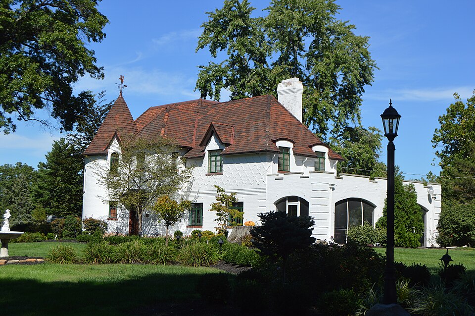
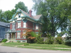
Photograph of Joseph and Cecilia Bappert House
Photograph by Nyttend, Public domain. Via Wikimedia Commons.

Bappert, Joseph and Cecilia, House

Listed on the National Register of Historic Places in 2016. A historic map-sheet match is not published yet. The record needs a coordinate-quality review before it can be joined to a sheet boundary.

From the record

“In 1849, shortly afterwards, he removed to Green township, Hamilton county, Ohio, and settled near Cheviot and again pursued his practice of medicine; but in 1859 the Democratic party in the county convention nominated him for the then lucrative office of county treasurer, supposed to be worth twenty-five thousand or thirty thousand dollars a year, and elected him over able and strong competitors. The county had been Republican the year before, having elected Henry Kessler sheriff by some twelve hundred majority.”

History of Hamilton County, Ohio, with Illustrations and Biographical Sketches (1881). Machine-read text.

one of 314 National Register listings in Hamilton County · listed in 2016 · category: Building · one of 9 National Historic Landmarks in Hamilton County.

Sources: the county history on the Internet Archive · the National Register database, National Park Service

The listing

  • What is counted as historic. The nomination lists 1 building, 1 structure as contributing to the listing.
  • Address. 1550 Neeb Rd., Cincinnati, 45238
  • When was it listed? 2016-09-06
  • Category. building
  • Township. Green township
  • National Register reference number. 16000596 - assigned by the National Park Service when the property was listed.

What happened here

An account from the chapter on Green township, The inset identifies its exact source book and publication year.

From History of Hamilton County, Ohio, with Illustrations and Biographical Sketches, published 1881 - Green Township

Mrs. Sidney S. Jackson

and a half years. He was also a member of the Walnut Hill school board, and laid the corner stone ffi the first school building built under the free school law. When the late war broke out he entered the army with four sons, two of whom were killed, one at Chancellorsville, the other murdered. He was in the first battle of the west at Vienna, and served, at one time, as a member of the staff.

Read the rest of this passage

The ground it stands on

20,298 words

The chapter on Green Township in History of Hamilton County, Ohio, with Illustrations and Biographical Sketches, published 1881 names Cincinnati. This is what it says, exactly as the scans read.

Green is the most regular and symmetrical township in the county. It is a perfe'ct square - an even surveyed township of thirty-six sections, six miles on a side, such as is common in the newer western and northern States, but not in the older settled regions, and of which no other instance is presented in Hamilton county. It lies altogether in fractional range two, township two, and is precisely included between the range and township lines, which separate it from Cincinnati and Mill Creek township on the east, Delhi on the south, Miami on the west, and Colerain on the north. Its section lines are run with remarkable correctness, considering that it lies wholly within the Miami Purchase, and might have shared in the troubles caused by the carelessness of the earliest surveyors. Save for some eccentricity in the second meridian east of the township line, the sections are mostly exact square miles, a fact which can be stated, probably, of no other tract of equal size within the Purchase. Still, its total acreage amounts to but twenty-two thousand seven hundred and fourteen - about an even half-section short of what it should be were all the sections full.

Passage source: History of Hamilton County, Ohio, with Illustrations and Biographical Sketches, published 1881.

Some of the most interesting and attractive drives in the county are through this township, upon the Cleves and Harrison turnpike, the Colerain pike, a mile of whose course lies through the northeastern corner, and other important roads, some of which lie, as in the newer States settled upon Congress lands, on the section lines. The Cincinnati & Westwood narrow-gauge railway lies mostly in Green township, and is at present the only iron road within its limits. Starting at Ernst Station, on the Cincinnati, Hamilton & Dayton railroad, in the city, it comes up the valley of Lick run, from which it soon diverges to reach the higher ground, across which it runs for more than three miles in a general northwesterly direction, stopping for the present at Robb's, near Bridgetown. The projected Cincinnati & Venice railway, if built upon the surveyed line, will enter the township from the north at St. Jacob's, proceed nearly due south four miles, and intersect this road just south of Cheviot.

Passage source: History of Hamilton County, Ohio, with Illustrations and Biographical Sketches, published 1881.

Machine-read from a century-old scan, so expect the errors a machine makes: misspelled names, dropped words, stray characters.

Read the whole chapter on Green Township - 20,298 words on its settlement, mills, schools and churches.

Specimens collected near this property

12 of 4,394 shown

Regional context, not property-specific evidence. Museums hold 4,394 specimens collected within 10 miles of Bappert, Joseph and Cecilia, House between 1819 and 1975: 1,961 Fungi, 1,444 Animalia, 826 Plantae, 123 Protozoa, 21 Unrecorded, 18 Chromista, 1 Bacteria. 12 distinct Species records are shown. Collected by A Schwartz, A. Braun, A. F. Braun and others. Each is a physical object with a catalogue number, and each entry opens the museum's record. This is what was collected and kept, not a survey of what lives here - nothing can be concluded from a species being absent.

Image SpeciesYear Collected by Where, as recorded
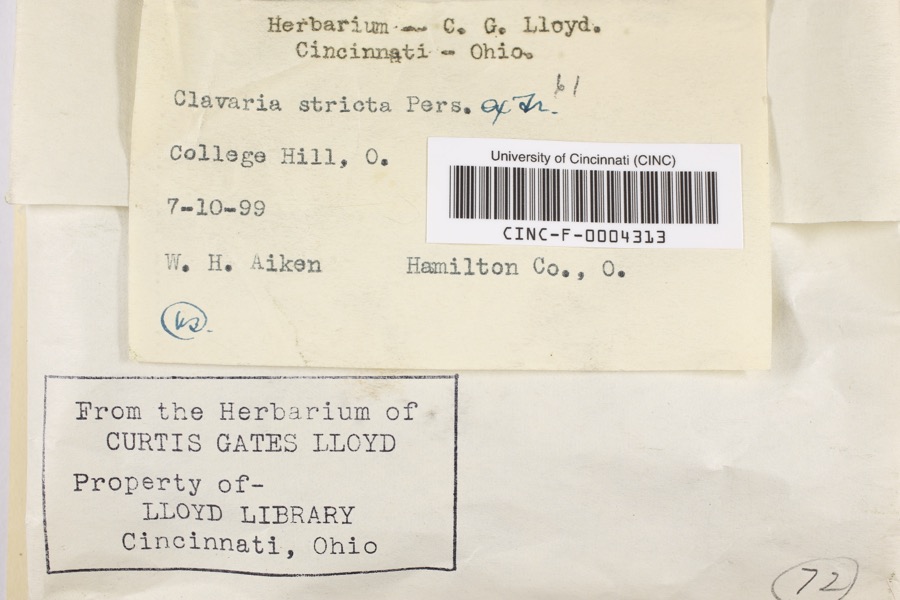
Specimen of Clavaria striata Pers.Clavaria striata Pers.1899Aiken, Walter H.College Hill
Specimen of Corticium polyporoideum Berk. & M.A.CurtisCorticium polyporoideum Berk. & M.A.Curtis1899C.G. LloydCincinnati
Specimen of Microsphaera diffusa Cooke & PeckMicrosphaera diffusa Cooke & Peck1899Aiken, Walter H.Cincinnati
A photograph of the species Quercus leana, not of this specimenQuercus × leana Nutt.1819Thomas Nuttall3 miles North of Cincinnati
A photograph of the species Atrichum angustatum, not of this specimenAtrichum angustatum (Brid.) Bruch & Schimp.1820T. G. Leaprobably Cincinnatti
A photograph of the species Barbula unguiculata, not of this specimenBarbula unguiculata Hedw.1820T. G. Leaprobably Cincinnatti
A photograph of the species Rhus venenata, not of this specimenRhus venenata DC.1830Clark, JosephNorth of Cincinnati
A photograph of the species Equisetum arvense, not of this specimenEquisetum arvense L.1834Short, Charles Wilkins; Lea, Thomas G.Cincinnati
A photograph of the species Carex comosa, not of this specimenCarex comosa Boott1835Collector unspecifiedIn citivate Ohio prope Cincinnati. [Inferred locality from precise loc.]
A photograph of the species Carex davisii, not of this specimenCarex davisii Schwein. & Torr.1835Frankin ditione Miami civitatis Ohio
A photograph of the species Carex lupulina, not of this specimenCarex lupulina Muhl. ex Willd.1835Joseph C. FrankCincinnati.
Albugo candida (Pers. ex J.F.Gmel.) Roussel1897Kellerman, W.A.College Hill

All 4,394 specimens within 10 miles, at the Global Biodiversity Information Facility.

Mines and quarries near this property

5 within 5 miles

Regional context, not property-specific evidence. The federal mineral resources record lists 5 workings within 5 miles of Bappert, Joseph and Cecilia, House: 3 past producers, 2 producers. 2 still produce. What was taken out: Salt, Stone, Crushed/Broken, Sand and Gravel, Construction. Distance is straight-line from the map coordinates, so a quarry counted here may appear on a neighbouring settlement's page as well.

Where SiteCommodity StatusRecorded
Constance YardStone, Crushed/BrokenProducer
Taylorsport MineSand and Gravel, ConstructionProducer
Cargill Salt TerminalSaltPast Producer
Cincinnati Salt ServiceSaltPast Producer
Cincinnati WarehouseSaltPast Producer

Every working recorded in Hamilton County

Storms near this property

60 of 70 shown

Regional context, not property-specific evidence. The National Weather Service names Cincinnati, the town this property stands in, in 70 storm reports between 1994 and 2025: 25 thunderstorm wind, 17 hail, 14 flash flood, 7 flood. The reports record 1 injury. Each account below is quoted exactly as the forecast office filed it, from the NOAA Storm Events Database, and each date opens the federal record of that event.

WhenEvent Place namedHarm What the report says
March 2001LightningCincinnati1 hurtA woman was injured when lightning struck the building and went through electronic equipment into her phone headset.
March 2017FloodCincinnati$100,000Dozens of basements were flooding across Hamilton County due to high water.
November 2017Flash FloodCincinnati$100,000Numerous roads were flooded throughout the Cincinnati area and some basements were flooded. Flooding also caused some damage at Reading High School and Whitaker Elementary School.
February 2000LightningCincinnati$100,000Lightning struck a home causing a fire in the attic, which spread toward the second floor before being extinguished. Significant fire and water damage occurred to the home.
August 2000LightningCincinnati$80,000Lightning struck a home causing a fire on the second floor.
January 1997Thunderstorm WindCincinnati$70,000no account filed
July 1994Thunderstorm WindCincinnati$50,000Trees were downed. Ceiling tiles were ripped from a parking garage and at least one car was damaged.
January 1997LightningCincinnati$50,000no account filed
July 1996LightningCincinnati$50,000no account filed
July 1998LightningCincinnati$40,000Lightning struck a home causing a fire, which caused significant damage.
April 2024Flash FloodCincinnati$30,000Three units of apartments along MLK Drive had to be evacuated due to high water. Rushing water also caused damage to some roads in Columbia Township.
September 2018Flash FloodCincinnati$30,000High water was reported on several roads in the downtown Cincinnati area and the near West Side. A retaining wall collapsed onto a roadway near the intersection of State Avenue and Ernst Street and a building was flooded on Poplar Street. Also, an apartment basement flooded on Linn Street and one resident needed to be rescued.
November 2013Thunderstorm WindCincinnati$20,000Two trees fell on two cars due to thunderstorm winds.
June 2019Flash FloodCincinnati$15,000High water was reported at I-471 and I-71.
December 2006Thunderstorm WindCincinnati$15,000Trees and power lines were knocked down across the Cincinnati metro area.
June 2017FloodCincinnati$10,000There were reports of lingering high water on roadways and some roads remained closed.|Also, there were reports of some basement flooding in homes.
July 2015Thunderstorm WindCincinnati$10,000Numerous trees and power lines were downed throughout downtown Cincinnati.
July 2012Flash FloodCincinnati$10,000Vehicles were reported trapped in high water due to heavy rainfall near Gest Street and Dalton Avenue.
September 2000Thunderstorm WindCincinnati$10,000Trees downed across Cincinnati.
June 2008Thunderstorm WindCincinnati$8,000Trees were knocked down across the county.
July 2020Thunderstorm WindCincinnati$7,000A large tree fell onto a carport and a garage on Considine Lane.
May 2020Flash FloodCincinnati$5,000A person had to be rescued from their car due to swift moving high water.
October 2010Thunderstorm WindCincinnati$5,000A roof was partially torn off of an apartment building due to damaging thunderstorm winds.
April 2002Thunderstorm WindCincinnati$5,000Several trees were knocked down throughout the Clifton area.
July 2001Thunderstorm WindCincinnati$5,000Thunderstorm winds knocked down trees.
April 2000Thunderstorm WindCincinnati$5,000Trees and power lines downed. One tree fell across a car.
June 1997Flash FloodCincinnati$5,000Numerous roads flooded due to persistent heavy rainfall.
May 1996Thunderstorm WindCincinnati$5,000no account filed
June 1996Thunderstorm WindCincinnati$5,000no account filed
July 2006Thunderstorm WindCincinnati$4,000Trees and powerlines were downed just north of downtown.
May 2002Flash FloodCincinnati$4,000High water occurred on River Road near the Krohn Conservancy.
February 2011Thunderstorm WindCincinnati$3,000Numerous trees were reported down due to damaging thunderstorm winds.
January 2008Thunderstorm WindCincinnati$3,000Large trees were knocked down.
March 2007FloodCincinnati$3,000Several roads were flooded and closed throughout the Cincinnati metro area.
October 2007HailCincinnati$3,000Hail ranging from penny to quarter sized occurred from downtown Cincinnati north and east into the Norwood area.
July 2001Thunderstorm WindCincinnati$3,000Large limbs were knocked down.
July 1997Thunderstorm WindCincinnati$3,000Trees downed.
June 2010Flash FloodCincinnati$2,000Some neighborhoods had flooded streets due to heavy rainfall.
June 2010Flash FloodCincinnati$2,000High water was reported over Interstate 74 and Interstate 75.
August 2010Thunderstorm WindCincinnati$2,000A couple of trees and some power lines were reported down across the northern part of the city.
July 2017Thunderstorm WindCincinnati$1,000A tree was downed between Sycamore and Main Streets.
July 2015Thunderstorm WindCincinnati$1,000A large tree was downed.
March 2012Flash FloodCincinnati$1,000The second report of flash flooding due to heavy rain in Hamilton County was water rushing across roads in and around the downtown area.
April 2011Thunderstorm WindCincinnati$1,000Large tree branches were broken due to damaging thunderstorm winds.
April 2011Heavy RainCincinnati$1,000A portion of Interstate 471 had high water on it due to heavy rainfall.
December 2011FloodCincinnati$1,000Several roads were reported closed across the county due to flooding caused by heavy rain.
August 2025FloodCincinnati-Water was flowing down the Elsinore Place Steps.
March 2023HailCincinnati-Nickel sized hail was reported in Mt. Auburn.
March 2019FloodCincinnati-Part of eastbound U.S. 50 was closed due to high water at the Freeman Avenue exit.
September 2018FloodCincinnati-Central Parkway was closed due to high water.
April 2015HailCincinnati-Dime size hail fell at the intersection of Lehmann and Radcliffe Roads.
June 2009HailCincinnati-Several reports were received from in and around Cincinnati of three quarters to one inch hail.
May 2002Flash FloodCincinnati-Heavy rain caused street flooding through the city.
May 2002Flash FloodCincinnati-High water deposited debris at the intersection of Glenview and Kirby Roads.
October 1999HailCincinnati-Report taken from the Spring Grove section of Cincinnati.
July 1998Flash FloodCincinnati-Several hours of heavy rainfall caused water to flood across many of the city roads.
June 2016HailCincinnati-no account filed
April 2015HailCincinnati-no account filed
May 2012HailCincinnati-no account filed
July 2012HailCincinnati-no account filed

Every storm recorded in Hamilton County

Newspapers printed here

0 digitised pages

14 papers published in this town, digitised by the Library of Congress and free to read: 0 issues, 0 pages. Every page is searchable, so a name or a street can be looked for directly in what the town printed about itself at the time.

Map coverage status

No historic map-sheet match is published for this property yet. That does not mean no map exists. This record needs a coordinate-quality review before it can be joined to a sheet boundary. Browse the county's mapped places while that work is pending.

Listed places nearby

6 within 8 miles

Other National Register properties close enough to walk or drive between, ordered by distance from this one. Both positions come from the same geocoding pass that matched these properties to their map sheets.

Photograph PropertyDistance Listed
Pine Meer0.9 miles1982
Cheviot Fieldhouse2.4 miles2009
Williams, W. L., House2.5 miles1977
Westwood United Methodist Church2.7 miles1980
St. Aloysius--on--the--Ohio3.0 miles2014
Beech Avenue Houses3.1 miles1979

Sources for this property

National Archives recordThe nomination case file for reference 16000596 in Record Group 79.
Hamilton CountyAll 314 listed properties in this county.

Provenance

  • Listing record. National Park Service National Register of Historic Places, listed-properties dataset, current to 2026-05-22.
  • Map join. Address geocoded through the United States Census geocoder, then tested against the published boundary of every sheet in the USGS Historical Topographic Map Collection.
  • How this page is made. Listing fields come from federal records; map-sheet coverage is a labelled coordinate-to-boundary calculation, not a source-field claim.
  • Specimens. Global Biodiversity Information Facility (GBIF), https://www.gbif.org/. Only records licensed CC0 or CC BY are used. Records licensed CC BY-NC are excluded because this site carries advertising. Images are checked individually and any whose licence is non-commercial, no-derivatives or unreadable is refused.
  • Mines and quarries. USGS Mineral Resources Data System (MRDS) https://mrdata.usgs.gov/mrds/ A work of the United States government, no copyright under 17 U.S.C. 105.
  • Storms. NOAA National Centers for Environmental Information, Storm Events Database https://www.ncei.noaa.gov/stormevents/ A work of the United States government, no copyright under 17 U.S.C. 105. Narratives are quoted verbatim from the National Weather Service report and are not edited or summarised.