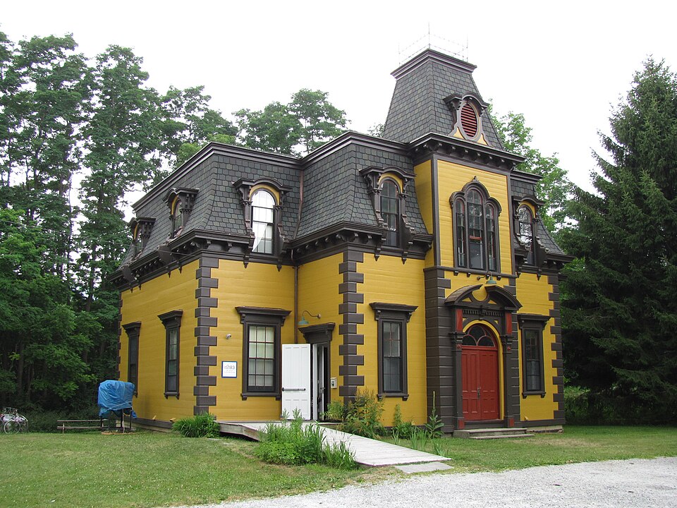
Built in 1870 in the Second Empire architecture in the United States and Canada. Listed on the National Register of Historic Places in
1972. A historic map-sheet match is not published yet. The record needs a coordinate-quality review before it can be joined to a sheet boundary.
From the record
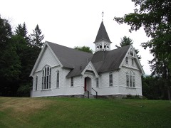
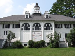
“Citizens Hall is a historic municipal building at 13 Willard Hill Road in Interlaken, a village of Stockbridge, Massachusetts. Built in 1870 as a schoolhouse and community meeting center, it is a well-preserved local example of Second Empire architecture.”
Wikipedia article Citizens Hall, CC BY-SA 4.0.
one of 94 National Register listings in Berkshire County · listed in 1972 · category: Building · built in 1870, Second Empire architecture in the United States and Canada, by Charles T. Rathbun · one of 1 National Historic Landmarks in Berkshire County.
Architectural style. Second Empire architecture in the United States and Canada
Architect. Charles T. Rathbun
National Register reference number.72000126- the number the National Park Service assigned this property when it was listed, and the key its nomination file is catalogued under at the National Archives.
Fires near this property
41 since 2002
Regional context, not property-specific
evidence. The
federal wildfire occurrence database
lists 41 fires within 5 miles of Citizens Hall between
2002 and 2020, burning about 29 acres in total. 2 started naturally. 1 was recorded as arson.
Distance is straight-line from the map coordinates, so a fire counted
here may appear on a neighbouring settlement's page as well.
Reported cause
Fires
Debris and open burning
17
Equipment and vehicle use
6
Recreation and ceremony
6
Missing data/not specified/undetermined
5
Natural
2
Other causes
2
Arson/incendiarism
1
Power generation/transmission/distribution
1
Railroad operations and maintenance
1
The most recent of
them, most recent first, with the day each was reported and the service
that recorded it.
Regional context, not property-specific
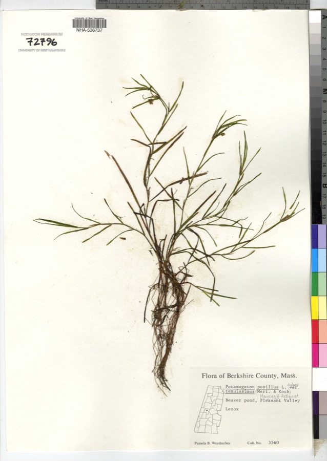
evidence. Museums hold 1,896 specimens
collected within 10 miles of Citizens Hall between 1833 and
1975: 833 Animalia, 808 Plantae, 248 Fungi, 3 Protozoa, 2 Chromista, 2 Unrecorded. 12 distinct Species records are shown.
Collected by A W Evans, A. Brown, A. E. Treat and others. Each is a
physical object with a catalogue
number, and each entry opens the museum's record. This is what was
collected and kept, not a survey of what lives here - nothing can be
concluded from a species being absent.
Regional context, not property-specific
evidence. The federal mineral resources record lists
52 workings within 5 miles of Citizens Hall: 30 past producers, 16 producers, 4 occurrences, 1 prospect.
16 still produce. What was taken out: Iron, Sand and Gravel, Construction, Stone, Crushed/Broken, Limestone, General. Distance is straight-line from the
map coordinates, so a quarry counted here may appear on a neighbouring
settlement's page as well.
Regional context, not property-specific
evidence. The National Weather Service names
Interlaken, the town this property stands in, in 4 storm reports between 2016 and 2022: 4 thunderstorm wind.
No death or injury is recorded in these reports. Each account below is quoted exactly as the forecast office
filed it, from the NOAA Storm Events Database, and each date
opens the federal record of that event.
No historic map-sheet match is published
for this property yet. That does not mean no map exists. This record needs
a coordinate-quality review before it can be joined to a sheet boundary.
Browse the county's mapped places while that work is
pending.
From the nomination file
2,727 words on record
When this property was proposed for the
National Register, someone wrote the case for it: what the building is,
and why it matters. That document is a federal record in the public domain.
It is quoted below word for word, never summarised. The text was read off the scanned case file by machine, so the
occasional stray character is the recogniser's and the 1970s
typewriter's.
Description of the property
Citizens Hall stands on a hill in the middle of a wide flat expanse of grass, with the Berkshire hill rising beyond. To the rear of the building, the land drops off in a woodland thicket, while dwellings built in the vernacular Greek Revival style flank it. The 1870 Hall is two stories high and has a gracefully curved Mansard roof. The boarded walls terminate in wooden quoins at each corner. Interrupted only by a tower, a wide cornice with elosely spaced and delicately detailed brackets encircles the Hall. Although the impression given is that of a nearly square building, the side facades are two bays wide and the main facade is five, with a three bay pavilion centered on it.
The middle bay of this pavilion projects slightly to form a two-story entrance tower which rises through the roof of the building. The tower walls are topped by a bracketed cornice identical to that below the main roof. The uppermost member of this cornice extends to form part of the curb between the two slopes of the main roof. The straight sides of the tower's roof taper and culminate in a simple cornice. Above this rises the crown of the tower -- a lacy, ornamental iron balustrademm The imposing main entrance in the tower is topped by a broken roundheaded pediment which is supported on each side of the door by a single elongated pilaster with ornamented capital. Beneath the pediment, the elaborately decorated entabla- ture is broken by a semi-circular light over the door.
The shape of this light echoes the curves of the roundheaded dormer windows.
Citizens Hall, which was built in 1870, is primarily significant for its architecture. It is a small-scale version of the civic buildings constructed in the Second Empire (Mansard) and Italianate styles in major American cities following the Civil War. In Citizens Hall, that typically stone and brick architecture is translated into a wooden rural idiom and combined with elements which reflect the characteristic exuberance of the Victorian period. The Hall is the architectural epicenter of Curtisville, a small community within the Town of Stockbridge, which grew up around twelve mills. The mills are gone but several small dwellings in Greek Revival vernacular style, a brick store building, a Federal brick church and a Greek Revival inn remain.
Historical records for Citizens Hall are scant and most are contained in the Selectmen's Report for the Town of Stockbridge for the year ending April 1, 1871. According to that report, Citizens Hall was designed by C. T. Rathbun. The construction of the building was the result of a new system of school administration begun in Stockbridge in 1866. Existing school districts were abolished and public education facilities were to be concentrated in the three business centers of the Town -- the Plains, Glendale and Curtisville. The two rooms on the first floor of Citizens Hall housed the Curtisville school and the second floor was the community assembly hall. The Town of Stockbridge is negotiating the sale of the property to the Berkshire County Historical Society.
The sale of the property is with preservation restrictions approved by the Massachusetts Historical Commission (General Laws, Chapter 184, as most recently amended). These restrictions cover the exterior of the building and certain interior features.
Quoted from the National Register nomination
for reference 72000126, 12 pages, held by the National Archives in Record
Group 79. See the
catalogue record.
Listed places nearby
6 within 8 miles
Other National Register properties close
enough to walk or drive between, ordered by distance from this one. Both
positions come from the same geocoding pass that matched these properties
to their map sheets.
Listing record. National Park Service National Register of Historic Places, listed-properties dataset, current to 2026-05-22.
Map join. Address geocoded through the United States Census geocoder, then tested against the published boundary of every sheet in the USGS Historical Topographic Map Collection.
How this page is made. Listing fields come from federal records; map-sheet coverage is a labelled coordinate-to-boundary calculation, not a source-field claim.
Wildfire. Short, Karen C. 2022. Spatial wildfire occurrence data for the United States, 1992-2020 [FPA_FOD_20221014]. 6th Edition. Fort Collins, CO: Forest Service Research Data Archive. https://doi.org/10.2737/RDS-2013-0009.6 Collected with United States Government funding and usable without additional permissions or fees.
Specimens. Global Biodiversity Information Facility (GBIF), https://www.gbif.org/. Only records licensed CC0 or CC BY are used. Records licensed CC BY-NC are excluded because this site carries advertising. Images are checked individually and any whose licence is non-commercial, no-derivatives or unreadable is refused.
Mines and quarries. USGS Mineral Resources Data System (MRDS) https://mrdata.usgs.gov/mrds/ A work of the United States government, no copyright under 17 U.S.C. 105.
Storms. NOAA National Centers for Environmental Information, Storm Events Database https://www.ncei.noaa.gov/stormevents/ A work of the United States government, no copyright under 17 U.S.C. 105. Narratives are quoted verbatim from the National Weather Service report and are not edited or summarised.
 Block
Block