Listed on the National Register of Historic Places in
1973. A historic map-sheet match is not published yet. The record needs a coordinate-quality review before it can be joined to a sheet boundary.
From the record
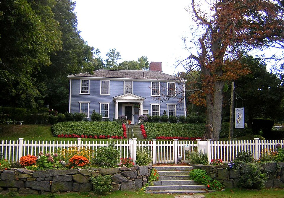
“The Suffolk Resolves House, also known as the Daniel Vose House, is a historic house at 1370 Canton Avenue in Milton, Massachusetts. It has long been claimed that this building was where the Suffolk Resolves were signed on September 4, 1774.”
Wikipedia article Suffolk Resolves House, CC BY-SA 4.0.
one of 249 National Register listings in Norfolk County · listed in 1973 · category: Building · one of 2 National Historic Landmarks in Norfolk County.
National Register reference number.73000308- the number the National Park Service assigned this property when it was listed, and the key its nomination file is catalogued under at the National Archives.
Mr. Hunt was born in Scott's Woods, Milton. He is remembered with great affection as connected with the Sabbath School of the First Evangelical Church in his boyhood. The pastor of this church has followed him with the watchful interest of a sincere friend in his education and progress onward to the place he now occupies.
Since the above date a handsome church edifice has been erected on the Dorchester side, where the shepherd gathers his Milton and Dorchester flock. May the prophetic words come to pass : " There shall they lie in a good fold, and in a fat pasture shall they feed." - Ezekicl xxxiv. 14.
Regional context, not property-specific
evidence. The
federal wildfire occurrence database
lists 177 fires within 5 miles of Suffolk Resolves House between
2003 and 2020, burning about 419 acres in total. None started naturally. None was recorded as arson.
Distance is straight-line from the map coordinates, so a fire counted
here may appear on a neighbouring settlement's page as well.
Reported cause
Fires
Recreation and ceremony
100
Missing data/not specified/undetermined
41
Smoking
28
Equipment and vehicle use
5
Debris and open burning
2
Railroad operations and maintenance
1
The most recent of
them, most recent first, with the day each was reported and the service
that recorded it.
Regional context, not property-specific
evidence. Museums hold 13,248 specimens
collected within 10 miles of Suffolk Resolves House between 1810 and
1975: 5,045 Plantae, 4,289 Fungi, 3,337 Animalia, 291 Protozoa, 187 Chromista, 63 Unrecorded, 36 Bacteria. 12 distinct Species records are shown.
Collected by (MARSDEN, H W), ?, ? ex Herb. W.G. Farlow and others. Each is a
physical object with a catalogue
number, and each entry opens the museum's record. This is what was
collected and kept, not a survey of what lives here - nothing can be
concluded from a species being absent.
Regional context, not property-specific
evidence. The federal mineral resources record lists
5 workings within 5 miles of Suffolk Resolves House: 2 unknowns, 2 producers, 1 past producer.
2 still produce. What was taken out: Sand and Gravel, Construction, Stone, Crushed/Broken, Granite. Distance is straight-line from the
map coordinates, so a quarry counted here may appear on a neighbouring
settlement's page as well.
Regional context, not property-specific
evidence. The National Weather Service names
Milton, the town this property stands in, in 21 storm reports between 1996 and 2025: 9 thunderstorm wind, 5 lightning, 4 heavy rain, 1 hail.
The reports record 3 injuries. Each account below is quoted exactly as the forecast office
filed it, from the NOAA Storm Events Database, and each date
opens the federal record of that event.
Lightning struck a house on Augusta Road, causing a fire that engulfed the entire third floor of the house. No one was home at the time of the fire. Three firefighters were hospitalized for heat exhaustion but were released less than 24 hours later.
No historic map-sheet match is published
for this property yet. That does not mean no map exists. This record needs
a coordinate-quality review before it can be joined to a sheet boundary.
Browse the county's mapped places while that work is
pending.
From the nomination file
2,016 words on record
When this property was proposed for the
National Register, someone wrote the case for it: what the building is,
and why it matters. That document is a federal record in the public domain.
It is quoted below word for word, never summarised. The text was read off the scanned case file by machine, so the
occasional stray character is the recogniser's and the 1970s
typewriter's.
Description of the property
É Moved Original Site residence beside the Neponset River in Milton Village, now stands atop a tree-studded knoll in one of Milton's attractive residential neighborhoods. Open fields and woods flank the property on two sides. Landscape features include 18th century-style flower and vegetable gardens. In order to ensure the preservation of the property, the deed to the Suffolk Resolves House was given to the Milton Historical Society in 1950. However, the Society was unable to finance restoration and the house was threatened with destruc- tion. The Society then deeded the house to Dr. and Mrs. James Ayer and it was moved to their property on Canton Avenue later the same year. At that time the building was repaired and restored.
It was later deeded back to the Milton Historical Society, which operates the property as a museum. 0.3 The wooden clapboard building has two stories. Two large interior chimneys project above the shallow hipped roof. The facade is five bays wide; the northeast elevation is two bays and the southwest elevation, incorporating the addition to the structure, is three. Twelve-over-twelve sash windows, with Doric window cornices, are used throughout. On the northwest front, the center entrance is ornamented with a simple architrave surround and covered by a porch supported by Roman-Doric columns and pilasters. The entablature and pediment contain dentil detail.
A small pane of glass, penetrating the clapboard covering, but not the wall, was placed to the right of the door enabling museum visitors to examine the construction techniques used in joining the two parts of the Suffolk Resolves House: on the left (looking at the facade from Canton Avenue) is the earlier portion, constructed about 1760; to the right is the addition to the structure made by Vose in 1773.
The Suffolk Resolves House has political significance as a surviving building associated with an historic pre-Revolutionary War event. The Suffolk Resolves was a statement expressing the Massachusetts Bay Colony's dissatisfaction with England's punitive colonial policies; the adoption of the Resolves by the Suffolk County conven- tion in 1774 was one of the first steps taken to organize opposition to these policies prior to the Revolution. The document was among the many local anti-British statements of the time: its distinction comes from its immediate endorsement by the First Continental Congress at Philadelphia.
The tax on tea of 1773; closing the port of Boston in 1774; a ban on holding town meetings without consent of the Royal Governor and other repressive acts by the British had made virtual slaves of the Massachusetts Bay Colony and the City of Boston. One form of resistance to this tyranny was the formation of county conven- tions which met throughout Massachusetts to formulate resolutions protesting the indifference and intransigence of King George III and Parliament in the years before the convening of the First Continental Congress at Philadelphia in 1774. Since town meetings were severely restricted, "county conventions" were substituted.
They were held, whenever possible, in rural locations to encourage the country people to make common cause with Boston and to remain, in the words of Samuel Adams, as "free from interference" as possible. By 1774 the political and economic situation had become intolerable, causing prominent Boston-area citizens, including many who were members of their local Committees of Correspondence, to meet with the Suffolk County convention in order to protest the coercive measures in use against Massachusetts. On April 16, 1774, the convention held a preliminary meeting at Doty's Tavern in Stoughton. They reconvened on September 6 at Woodward Tavern, Dedham. Dr.
Quoted from the National Register nomination
for reference 73000308, 8 pages, held by the National Archives in Record
Group 79. See the
catalogue record.
Listed places nearby
6 within 8 miles
Other National Register properties close
enough to walk or drive between, ordered by distance from this one. Both
positions come from the same geocoding pass that matched these properties
to their map sheets.
Listing record. National Park Service National Register of Historic Places, listed-properties dataset, current to 2026-05-22.
Map join. Address geocoded through the United States Census geocoder, then tested against the published boundary of every sheet in the USGS Historical Topographic Map Collection.
How this page is made. Listing fields come from federal records; map-sheet coverage is a labelled coordinate-to-boundary calculation, not a source-field claim.
Wildfire. Short, Karen C. 2022. Spatial wildfire occurrence data for the United States, 1992-2020 [FPA_FOD_20221014]. 6th Edition. Fort Collins, CO: Forest Service Research Data Archive. https://doi.org/10.2737/RDS-2013-0009.6 Collected with United States Government funding and usable without additional permissions or fees.
Specimens. Global Biodiversity Information Facility (GBIF), https://www.gbif.org/. Only records licensed CC0 or CC BY are used. Records licensed CC BY-NC are excluded because this site carries advertising. Images are checked individually and any whose licence is non-commercial, no-derivatives or unreadable is refused.
Mines and quarries. USGS Mineral Resources Data System (MRDS) https://mrdata.usgs.gov/mrds/ A work of the United States government, no copyright under 17 U.S.C. 105.
Storms. NOAA National Centers for Environmental Information, Storm Events Database https://www.ncei.noaa.gov/stormevents/ A work of the United States government, no copyright under 17 U.S.C. 105. Narratives are quoted verbatim from the National Weather Service report and are not edited or summarised.
 Block
Block