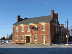
Built in 1820. Listed on the National Register of Historic Places in
1973. A historic map-sheet match is not published yet. The record needs a coordinate-quality review before it can be joined to a sheet boundary.
From the record
“The Valentine Wilson House was a historic residence in Madison County, Ohio, United States. Located off Interstate 70 about 1 mile (1.6 km) north of Summerford, it was the home of pioneer Valentine Wilson.”
Wikipedia article Valentine Wilson House, CC BY-SA 4.0.
one of 7 National Register listings in Madison County · listed in 1973 · category: Building · built in 1820.
National Register reference number.73001505- the number the National Park Service assigned this property when it was listed, and the key its nomination file is catalogued under at the National Archives.
The ground it stands on
3,370 words
The chapter on Somerford Township in History of Madison County Ohio, published 1915 names Somerford. This is what it says, exactly as the scans read.
Somerford township lies along the western border of Madison: 'county, second from the northern border. It:is bounded:on the north by Pike. and Monroe townships, on the east by Monroe and Deer Creeks townships, on the south by Union township and on the west by Champaign county and Clark county. The following was taken from the record books of the county commissioners, dated March 4, 1839: "Ordered, by the commissioners, that the following' boundaries, which have heretofore been'a part of Deer Creek township, be organized as a new township, to'be known and designated by' the name of Somerford, to wit: Beginning at the 'southwest cornet of Piké township, in the line of Champaign county; thence with the'said line south three Iniles and two hundred poles to the corner between the county of Chanipaign and Clark'; "thehee with the Clark' county line south ten degrees west, six and a half 'miles to the north bank of Deér creek, on Daniel Wilson's land; thence north seventy-seven degrees ' east; four miles and one hundred eighty poles, crossing the Urbana road and Glade run to two black oaks and two burr oaks near where George Frederick 'formerly lived, on A. 'Poland's land ; thence north to the line of Monroe and Pike townships north forty- six degrees west five miles to the beginning. " The next and last record we find concerning the boundary line of Somerford township is 'in the record book, dated March 20, 1840, and is as follows : "Ordered, by the commissioners of Madison 'county, that the line between the townships of Union and Somerford be so altered as to include Daniel Wilson's and the land' upon which he now lives into Union township."
The soil is. very rich. and productive, and suitable to, the raising of all _kinds of grains, cereals and grasses, the exuberance of the latter making it an excellent stock country, Along, the creeks and the more flat portions of the township, the soil consists of a deep black loam, and the more undulating lands are a mixture, of loam and clay. The township is well watered by the creeks, whica also prove invaluable for drainage and which are fed by reLea ty numbers of beautiful springs. These springs dot the farms from one extreme to the other of the limited domain. Deer creek, with its numerous branches, penetrate all portions of the territory. George's ereek, the largest branch, heads near the northwest corner of the township, and, coursing in a southeast direction. empties into the main creek, near the eastern border of the township. With all the beautiful Springs and creeks,. forming an ever- -gushing supply of water, together with the subsoil of clay, this township is "proof against danger. to its crops from an ordinary drought. Somerford township, unlike many others of Madison 'county, was originally well timbered, having no prairies entirely destitute of trees; and it might be stated that it had a very remarkable variety of timber, consisting of white, black, red and burr oak, elm, maple, locust, cherry, hickory, walnut and beech, of which the white and red oak were the most beautiful growths; the cherry and walnut, of which, in an early day, vast quantities were cut down and burned in clearing up the land, if now in possession of the owners of these lands, would alone be worth a fortune. But the ruthless axe of the pioneers and his merciless torch nearly obliterated these species from the township. Owing to the small size of the streams, there is no water power of value, and the mills that now exist, or have existed in this township, have been run by steam power. Therefore, the greatest efforts, and the interests of the people, with the natural advanages they possessed as above described, have been along lines of agricultural pursuits.
Regional context, not property-specific
evidence. The federal mineral resources record lists
2 workings within 5 miles of Wilson, Valentine, House: 2 past producers.
None of them still produces. What was taken out: Sand and Gravel, Construction. Distance is straight-line from the
map coordinates, so a quarry counted here may appear on a neighbouring
settlement's page as well.
No historic map-sheet match is published
for this property yet. That does not mean no map exists. This record needs
a coordinate-quality review before it can be joined to a sheet boundary.
Browse the county's mapped places while that work is
pending.
From the nomination file
1,687 words on record
When this property was proposed for the
National Register, someone wrote the case for it: what the building is,
and why it matters. That document is a federal record in the public domain.
It is quoted below word for word, never summarised. The text was read off the scanned case file by machine, so the
occasional stray character is the recogniser's and the 1970s
typewriter's.
Description of the property
a chimney stack (part of which has fallen in) and small gable- been replaced downstairs but remain in the upstairs bedrooms. All In spite of the leaking roof, falling plaster, warping floor (continued on contin. sheet) with wooden trim and mantel piece.
NATION not trim along the rakes thus creating wide expanses of uninter Shortly after the completion of the main structure, a one-story lor" design with additional one-story brick and wood structures end windows and contains a large fireplace, simply appointed The plain wall surfaces are a consequence walnut woodwork including built-in cupboards and superb original is slightly pinker and lighter in color than the rest of the six-panel doors.A circular "ladder" stair ascends from the hal six symetrically placed openings, the front door being in the middle. a glorious rich color now somewhat subdued and made motley with of the rooms exhibit complete chair rails and excellently crafted east gable and not on the corresponding opposite gable.
RECONDITION southwest facade, but a common bond is used on all other exterior The main two-story section has tall internal gable-end chimney inset on the flu area between the attic windows on the south- The overall jointing used is very thin and the cement used a window and door, opening on the same side as the main facade, Prior to 1875,a common, one-story wooden frame structure was ad The Valentine Wilson House is a two-story, brick,"hall and par After l875,a simple porch was added to cover this door but has (Check One) to the attic. DESCRIPTION The wing has but two of the mantels remain. two-room addition was used as a hog pen in later years. Excellent Fair the house are not pierced by openings. the architectural character of the total structure. since been removed.
Valentine Wilson was Ohio, In 1816, where he bought 200 acres, of which he added to his death, it is believed that he owned the largest improved farm in the State of Ohio. His Darby Plains farm contained 50 and exterior, a certain boldness, and at the same time, a feel- ness area of Madison County, by a man of relative affluent gable-end chimneys and typically blank gable walls.
Therefore (continued on contin, sheet) Engineering Military Architecture Conservation Transportation Communications Other Theater Aboriginal Science Music Religion/Phi Literature SIGNIFICANCE itarian Sculpture Landscape Social/Human- The people of the Mid-Atlantic region influenced the North, ing of reserve that gives this piece of architecture a dignity Invention The Valentine Wilson House, orginally constructed in a wilder- Industry westward direction in which folk cultures were carried out of tidewater architecture in this Madison County area.
dle Atlantic architectural styles in folk housing to this migrant to the Mid-Atlantic region usually erected two-story Commerce circa l820,shows excellent refinement of details both interior Township, Madison County, Ohio.He Settled on original Virginia this source area by diffusion and migration.It of the National Trail. NATIONAL dwellings, one room deep, two or more rooms long with internal means, can serve to illustrate the transplantation of the Mid- Education miles of fencing and l,2oo acres in one pasture alone.
the Valentine Wilson House, so typical of this style of tide- REGISTER Art Political PERIOD (Check One or More as Appropriate) died July 2, 1855 in this, his brick farm home, in Somerford Military Survey #3726, then Deer Creek Township, Madison County, His first son, William D. Wilson, born in 180%, is called man. losophy County.
Quoted from the National Register nomination
for reference 73001505, 12 pages, held by the National Archives in Record
Group 79. See the
catalogue record.
Listed places nearby
4 within 8 miles
Other National Register properties close
enough to walk or drive between, ordered by distance from this one. Both
positions come from the same geocoding pass that matched these properties
to their map sheets.
Listing record. National Park Service National Register of Historic Places, listed-properties dataset, current to 2026-05-22.
Map join. Address geocoded through the United States Census geocoder, then tested against the published boundary of every sheet in the USGS Historical Topographic Map Collection.
How this page is made. Listing fields come from federal records; map-sheet coverage is a labelled coordinate-to-boundary calculation, not a source-field claim.
Mines and quarries. USGS Mineral Resources Data System (MRDS) https://mrdata.usgs.gov/mrds/ A work of the United States government, no copyright under 17 U.S.C. 105.
 Block
Block