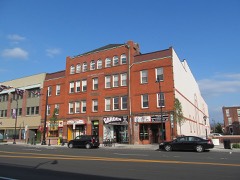
Listed on the National Register of Historic Places in
1975. A historic map-sheet match is not published yet. The record needs a coordinate-quality review before it can be joined to a sheet boundary.
From the record
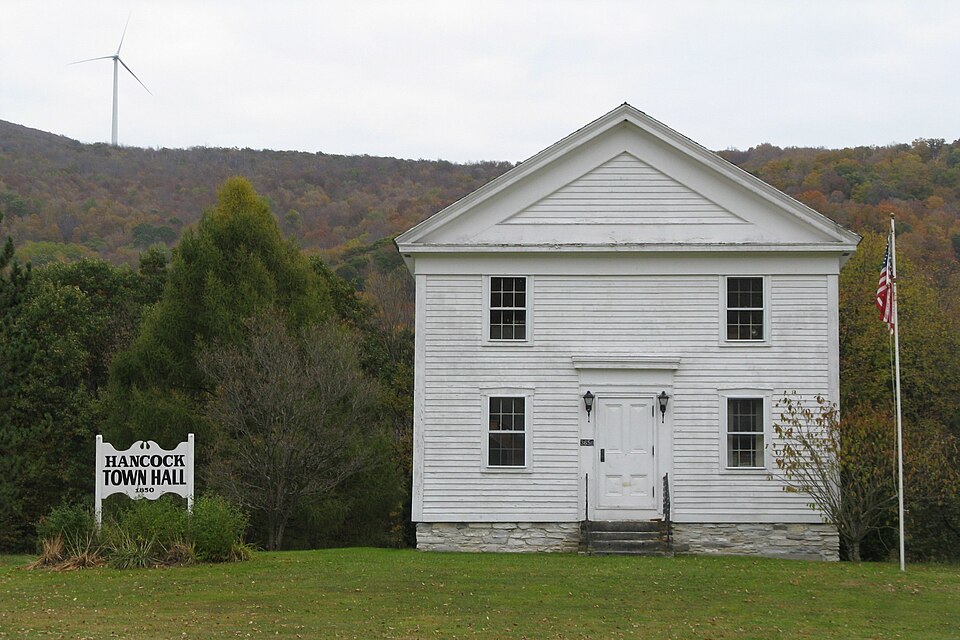
“Hancock Town Hall is a historic town hall on Massachusetts Route 43 in Hancock, Massachusetts. It was constructed in the Greek Revival style c. 1852, using timbers from a previous meeting house.”
Wikipedia article Hancock Town Hall, CC BY-SA 4.0.
one of 94 National Register listings in Berkshire County · listed in 1975 · category: Building · one of 1 National Historic Landmarks in Berkshire County.
National Register reference number.73001956- the number the National Park Service assigned this property when it was listed, and the key its nomination file is catalogued under at the National Archives.
Fires near this property
83 since 2000
Regional context, not property-specific
evidence. The
federal wildfire occurrence database
lists 83 fires within 5 miles of Hancock Town Hall between
2000 and 2020, burning about 206 acres in total. 8 started naturally. 14 were recorded as arson.
Distance is straight-line from the map coordinates, so a fire counted
here may appear on a neighbouring settlement's page as well.
Reported cause
Fires
Missing data/not specified/undetermined
36
Debris and open burning
18
Arson/incendiarism
14
Natural
8
Smoking
3
Recreation and ceremony
2
Equipment and vehicle use
2
The most recent of
them, most recent first, with the day each was reported and the service
that recorded it.
Regional context, not property-specific
evidence. Museums hold 1,024 specimens
collected within 10 miles of Hancock Town Hall between 1835 and
1975: 453 Animalia, 419 Plantae, 150 Fungi, 2 Unrecorded. 12 distinct Species records are shown.
Collected by A K Harrison, A Schwartz, A. K. Harrison and others. Each is a
physical object with a catalogue
number, and each entry opens the museum's record. This is what was
collected and kept, not a survey of what lives here - nothing can be
concluded from a species being absent.
Regional context, not property-specific
evidence. The federal mineral resources record lists
4 workings within 5 miles of Hancock Town Hall: 2 past producers, 1 producer, 1 occurrence.
1 still produces. What was taken out: Iron, Sand and Gravel, Construction. Distance is straight-line from the
map coordinates, so a quarry counted here may appear on a neighbouring
settlement's page as well.
Regional context, not property-specific
evidence. The National Weather Service names
Hancock, the town this property stands in, in 9 storm reports between 2000 and 2022: 5 thunderstorm wind, 2 hail, 1 lightning, 1 flash flood.
No death or injury is recorded in these reports. Each account below is quoted exactly as the forecast office
filed it, from the NOAA Storm Events Database, and each date
opens the federal record of that event.
Heavy rainfall from thunderstorms heavily damaged a 1.5 mile stretch of the Berry Pond Circuit Road in the Pittsfield State Forest in Pittsfield. As a result of the flash flooding, 13 popular campsites at Berry Pond had to be closed for the remainder of the summer season due to the damaged access road. A local newspaper reported that when the flash flooding occurred, campers had to be evacuated before water cascading down the mountain gouged out the paved road. The damage to the road and eleven stone culverts was estimated to be significant and will cost between $173,000 and $277,000 to repair.
A tree, along with wires were reported down on Route 43 in Hancock due to strong thunderstorm winds. An estimated wind gust of 60 miles per hour was also reported.
Thunderstorms developed along a frontal boundary, then moved into Berkshire county very late on August 9. Dime to nickel size hail was reported by a spotter in Hancock.
No historic map-sheet match is published
for this property yet. That does not mean no map exists. This record needs
a coordinate-quality review before it can be joined to a sheet boundary.
Browse the county's mapped places while that work is
pending.
From the nomination file
6,349 words on record
When this property was proposed for the
National Register, someone wrote the case for it: what the building is,
and why it matters. That document is a federal record in the public domain.
It is quoted below word for word, never summarised. The text was read off the scanned case file by machine, so the
occasional stray character is the recogniser's and the 1970s
typewriter's.
Description of the property
The Hancock Town Hall (c.1852) exemplifies the simplest and most prolific adaptation of the temple form of the Greek Revival style. Its short gable end faces west and contains the main entrance which is centered on the facade. A heavy entablature with boxed cornice encircles the clapboard-sided building directly above the second story windows and forms a pediment in the gable end. Segmental lintels top the first story windows, three on each of the long facades and one at each side of the entrance. Narrow cornerboards mark each corner of the building. A heavy, flat entablature rests over the door frame. The building is painted white with the door trimmed in green. Future plans include stripping the green paint and repainting the door white.
The Hancock Town Hall is two stories and measures 26'6" by 36'6". The interior plan includes a large meeting room which comprises the entire second floor and a central hall with two rooms on either side on the first floor. The walls are white plaster and the floors are wide pine. The original location of the Hancock Town Hall was on less than an acre of land in the middle of the Hancock town center. Facing onto Main Street, the building was bordered to the south by the tree-lined Kinderhook Creek, and on the remaining sides by village houses and public buildings typical of the 19th century- On August 29, 1975 the Hancock Town Hall was moved approximately ½ mile from its original location to a new site on Route 43.
The move was necessary because Hancock does not have a central sewage system and there was no room for a proper disposal system in the town center area. The Town Hall now sits on two acres of flat land next to the town cemetery.
/ARCHITECT The Hancock Town Hall is one of only three town halls in Berkshire County built specifically for that purpose. Until the functions of church and state were officially separated in Massachusetts around 1830, meetinghouses served both as town meeting places and houses of worship. Thus, the building of the Hancock Town Hall specifically for town meetings symbolizes the tra- dition of local government as it grew in Massachusetts. Although smaller in scale, the basic shape and design of the Town Hall reflect the traditional style of the New England meetinghouse. In its form and in certain architec- tural features, the Town Hall also resembles the schoolhouses constructed during this same period.
The simple and bold form and uncluttered lines of the Hancock Town Hall illustrate the classical revival style adapted to suit the needs and resources of a small, rural community. In the early 1850's the town of Hancock voted to demolish a local church on the Captain William Hadsell Farm and use the materials for the construction of a town hall. Instrumental in this project were selectmen William Hadsell and Benjamin Whitman. Although there was some opposition to the plan, a lawsuit was initiated which allowed the completion of the town hall. For a number of years, space was provided in the Town Hall for the Hancock Classical Institute, a private school which drew students from Hancock and the surrounding towns.
This was considered a college preparatory school, and a separate public school was maintained for the town. The first teacher at the Hancock Classical Institute was Hiram La Motte Lewis, a student at Williams College. Succeeding student teachers were selected with the advice of Williams' president Mark Hopkins.
Quoted from the National Register nomination
for reference 73001956, 33 pages, held by the National Archives in Record
Group 79. See the
catalogue record.
Listed places nearby
6 within 8 miles
Other National Register properties close
enough to walk or drive between, ordered by distance from this one. Both
positions come from the same geocoding pass that matched these properties
to their map sheets.
Listing record. National Park Service National Register of Historic Places, listed-properties dataset, current to 2026-05-22.
Map join. Address geocoded through the United States Census geocoder, then tested against the published boundary of every sheet in the USGS Historical Topographic Map Collection.
How this page is made. Listing fields come from federal records; map-sheet coverage is a labelled coordinate-to-boundary calculation, not a source-field claim.
Wildfire. Short, Karen C. 2022. Spatial wildfire occurrence data for the United States, 1992-2020 [FPA_FOD_20221014]. 6th Edition. Fort Collins, CO: Forest Service Research Data Archive. https://doi.org/10.2737/RDS-2013-0009.6 Collected with United States Government funding and usable without additional permissions or fees.
Specimens. Global Biodiversity Information Facility (GBIF), https://www.gbif.org/. Only records licensed CC0 or CC BY are used. Records licensed CC BY-NC are excluded because this site carries advertising. Images are checked individually and any whose licence is non-commercial, no-derivatives or unreadable is refused.
Mines and quarries. USGS Mineral Resources Data System (MRDS) https://mrdata.usgs.gov/mrds/ A work of the United States government, no copyright under 17 U.S.C. 105.
Storms. NOAA National Centers for Environmental Information, Storm Events Database https://www.ncei.noaa.gov/stormevents/ A work of the United States government, no copyright under 17 U.S.C. 105. Narratives are quoted verbatim from the National Weather Service report and are not edited or summarised.
 Block
Block