Listed on the National Register of Historic Places in
1974. A historic map-sheet match is not published yet. The record needs a coordinate-quality review before it can be joined to a sheet boundary.
From the record
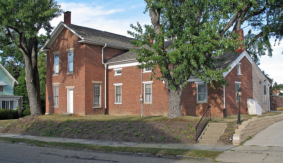
“The Haines House is a historic house in Alliance, Ohio that was an Underground Railroad station.”
Wikipedia article Haines House (Alliance, Ohio), CC BY-SA 4.0.
one of 81 National Register listings in Stark County · listed in 1974 · category: Building.
National Register reference number.74001623- the number the National Park Service assigned this property when it was listed, and the key its nomination file is catalogued under at the National Archives.
Specimens collected near this property
12 of 76 shown
Regional context, not property-specific
evidence. Museums hold 76 specimens
collected within 10 miles of Haines House between 1890 and
1975: 72 Animalia, 2 Fungi, 2 Plantae. 12 distinct Species records are shown.
Collected by Armbruster, D. C. (Daniel C.), Bryan, J. M., Collector(s): William D. Stull and others. Each is a
physical object with a catalogue
number, and each entry opens the museum's record. This is what was
collected and kept, not a survey of what lives here - nothing can be
concluded from a species being absent.
Regional context, not property-specific
evidence. The federal mineral resources record lists
3 workings within 5 miles of Haines House: 2 past producers, 1 producer.
1 still produces. What was taken out: Clay, Sand and Gravel, Construction, Coal. Distance is straight-line from the
map coordinates, so a quarry counted here may appear on a neighbouring
settlement's page as well.
Regional context, not property-specific
evidence. The National Weather Service names
Alliance, the town this property stands in, in 38 storm reports between 1995 and 2021: 22 thunderstorm wind, 13 hail, 2 flash flood, 1 lightning.
No death or injury is recorded in these reports. Each account below is quoted exactly as the forecast office
filed it, from the NOAA Storm Events Database, and each date
opens the federal record of that event.
Thunderstorm winds caused considerable damage in Alliance and adjacent Washington Township. Dozens of trees were downed in these areas. A house just south of Alliance was heavily damaged by a fallen tree. Several barns in Washington Township lost portions of roof and a couple mobile homes were also damaged.
Thunderstorm winds downed many trees south of Alliance. A large pole building sustained considerable damage and a home nearby was damaged by a fallen tree. Scattered power outages were reported in the area.
No historic map-sheet match is published
for this property yet. That does not mean no map exists. This record needs
a coordinate-quality review before it can be joined to a sheet boundary.
Browse the county's mapped places while that work is
pending.
From the nomination file
1,850 words on record
When this property was proposed for the
National Register, someone wrote the case for it: what the building is,
and why it matters. That document is a federal record in the public domain.
It is quoted below word for word, never summarised. The text was read off the scanned case file by machine, so the
occasional stray character is the recogniser's and the 1970s
typewriter's.
Description of the property
bay Federal style house. Destroyed sometime after 1915, and the various minor alterations have been removed. However, there woodwork is intact. There are ornamental mantelpieces but no fire- rectangular transom of the Greek Revival. Originally there was a Fair version of a Batty Langley design. The front door has the side lights and PERIOD (Check One or More as Appropriate) X 19th Century - Pre-Columbian! SPECIFIC DATE(S) (If Applicable and Known) - Prehistoric - Other (Specify) ] Religion/Phi- Indus try ] Science - Theater - Transportation STATEMENT OF
Statement of significance
house in Stark County, was built by John Grant, on a land grant of It was visited regularly by abolitionists Stephen S. Foster, Abby C. Haines, who died in 1942 at the age of 100 as the last remaining style house with a portico of two superimposed orders so far north in Ohio. A common type in Virginia, Kentucky, southern Ohio and Indiana, of the settlers of nearby Columbiana County, where the design also appears, were from Virginia, and alternatively, some were from New century state, including interior furnishings of Empire, Victorian and Eastlake periods, appropriate to the time of the Haines family.
FEB 1 2 1974 Commerce Architecture Communications losophy Military REGISTER NATIONAL Conservation Engineering Aboriginal SIGNIFICANCE Landscape Agriculture Education itarian Literature Political Music 1834/1842 Urban Planning undergone restoration to an approximation of its mid-nineteenth Invention Since its acquisition by the present owner in 1966, the house has it is extremely rare less than five miles from the Connecticut Western Sculpture Civil War veteran in Detroit.
1970, Mr.Johannesen was named Ohio's Outstanding Preservationist of The Haines house was an underground railroad station.The original 1834).In 1841 Grant's daughter Sarah married J.Ridgeway Haines, reliable source of information is the recollections of eldest son John wing of the house, according to one tradition the oldest brick already an abolitionist at the age of 2l.The house was completed The house is also important as an unusual example of a late Federal Jersey and the Philadelphia area. in 1842,and probably served as an underground station after 1853. Social/Human- 1812,in the 1830s county tax records show it in existence in Reserve. The transmission of the design is not ,yet clear, but many Art RECEIVED 1969 by the Ohio Association of Historical Societies.
Quoted from the National Register nomination
for reference 74001623, 11 pages, held by the National Archives in Record
Group 79. See the
catalogue record.
Listed places nearby
6 within 8 miles
Other National Register properties close
enough to walk or drive between, ordered by distance from this one. Both
positions come from the same geocoding pass that matched these properties
to their map sheets.
Listing record. National Park Service National Register of Historic Places, listed-properties dataset, current to 2026-05-22.
Map join. Address geocoded through the United States Census geocoder, then tested against the published boundary of every sheet in the USGS Historical Topographic Map Collection.
How this page is made. Listing fields come from federal records; map-sheet coverage is a labelled coordinate-to-boundary calculation, not a source-field claim.
Specimens. Global Biodiversity Information Facility (GBIF), https://www.gbif.org/. Only records licensed CC0 or CC BY are used. Records licensed CC BY-NC are excluded because this site carries advertising. Images are checked individually and any whose licence is non-commercial, no-derivatives or unreadable is refused.
Mines and quarries. USGS Mineral Resources Data System (MRDS) https://mrdata.usgs.gov/mrds/ A work of the United States government, no copyright under 17 U.S.C. 105.
Storms. NOAA National Centers for Environmental Information, Storm Events Database https://www.ncei.noaa.gov/stormevents/ A work of the United States government, no copyright under 17 U.S.C. 105. Narratives are quoted verbatim from the National Weather Service report and are not edited or summarised.
 Block
Block