BlockBefore
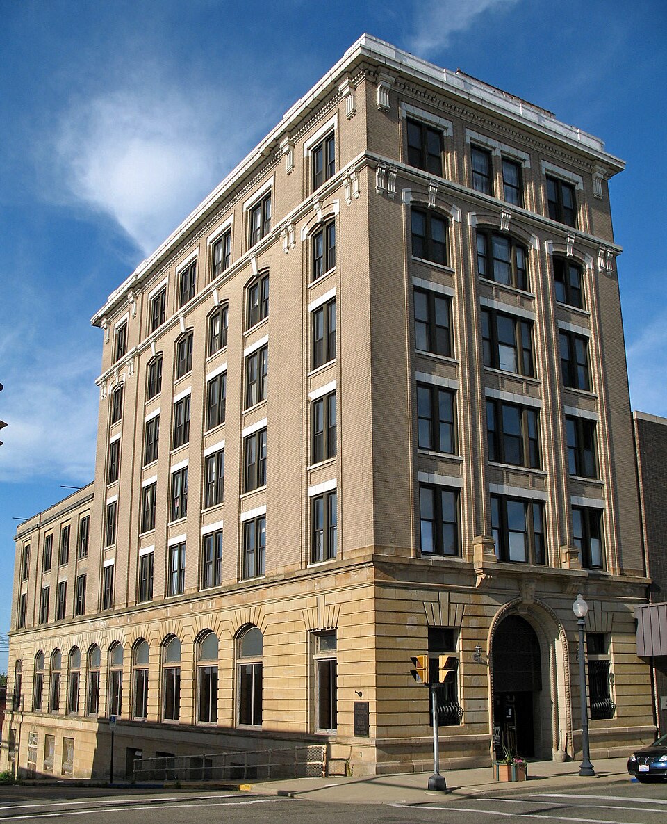
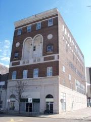
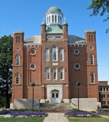
Photograph of Alliance Bank Building
Photograph by Sanfranman59, CC BY-SA 3.0. Via Wikimedia Commons.

Alliance Bank Building

Listed on the National Register of Historic Places in 1995. A historic map-sheet match is not published yet. The record needs a coordinate-quality review before it can be joined to a sheet boundary.

From the record

“The Alliance Bank Building is a historic bank building in Alliance, Ohio, listed on the National Register of Historic Places.”

Wikipedia article Alliance Bank Building, CC BY-SA 4.0.

one of 81 National Register listings in Stark County · listed in 1995 · category: Building.

Sources: the Wikipedia article · the case file at the National Archives · the National Register database, National Park Service

The listing

  • What is counted as historic. The nomination lists 1 building as contributing to the listing.
  • Address. 502 E. Main St., Alliance, 44601
  • When was it listed? 1995-07-28
  • Category. building
  • Township. Alliance city
  • Architectural style. Renaissance Revival architecture
  • National Register reference number. 95000940 - the number the National Park Service assigned this property when it was listed, and the key its nomination file is catalogued under at the National Archives.

Specimens collected near this property

12 of 75 shown

Regional context, not property-specific evidence. Museums hold 75 specimens collected within 10 miles of Alliance Bank Building between 1890 and 1975: 71 Animalia, 2 Fungi, 2 Plantae. 12 distinct Species records are shown. Collected by Armbruster, D. C. (Daniel C.), Bryan, J. M., Collector(s): William D. Stull and others. Each is a physical object with a catalogue number, and each entry opens the museum's record. This is what was collected and kept, not a survey of what lives here - nothing can be concluded from a species being absent.

Image SpeciesYear Collected by Where, as recorded
A photograph of the species Agelaius phoeniceus, not of this specimenAgelaius phoeniceus phoeniceus (Linnaeus, 1766)1890Paul MorrisAlliance, near
A photograph of the species Amblema plicata, not of this specimenAmblema plicata (Say, 1817)1893Sterki, VictorAlliance
A photograph of the species Picoides pubescens, not of this specimenPicoides pubescens medianus (Swainson, 1832)1903not recordedNew Baltimore
A photograph of the species Passerina ciris, not of this specimenPasserina ciris (Linnaeus, 1758)1905F. A. W. DeanAlliance
A photograph of the species Etheostoma variatum, not of this specimenEtheostoma variatum Kirtland, 18401930Trautman, M. B. (Milton Bernard) & Foster, R. (Robert)Mahoning River tributary, within north central Concord township, near Limaville, Lexington township
Eupelmidae1934VL WildermuthAlliance
A photograph of the species Carex alopecoidea, not of this specimenCarex alopecoidea Tuck.1937R. E. ShanksAtwater, Ohio.
A photograph of the species Ambloplites rupestris, not of this specimenAmbloplites rupestris (Rafinesque, 1817)1941Trautman, M. B. (Milton Bernard) & ScottDeer Creek, 0.25 mi west of Limaville, ~0.3 mi W of Limaville, Lexington township
A photograph of the species Ameiurus melas, not of this specimenAmeiurus melas melas (Rafinesque, 1820)1941Trautman, M. B. (Milton Bernard) & ScottDeer Creek, 0.25 mi west of Limaville, ~0.3 mi W of Limaville, Lexington township
A photograph of the species Campostoma anomalum, not of this specimenCampostoma anomalum anomalum1941Trautman, M. B. (Milton Bernard) & ScottDeer Creek, 0.25 mi west of Limaville, ~0.3 mi W of Limaville, Lexington township
A photograph of the species Catostomus commersonii, not of this specimenCatostomus commersonii (Lacepède, 1803)1941Trautman, M. B. (Milton Bernard) & ScottDeer Creek, 0.25 mi west of Limaville, ~0.3 mi W of Limaville, Lexington township
A photograph of the species Ericymba buccata, not of this specimenEricymba buccata Cope, 18651941Trautman, M. B. (Milton Bernard) & ScottDeer Creek, 0.25 mi west of Limaville, ~0.3 mi W of Limaville, Lexington township

All 75 specimens within 10 miles, at the Global Biodiversity Information Facility.

Mines and quarries near this property

3 within 5 miles

Regional context, not property-specific evidence. The federal mineral resources record lists 3 workings within 5 miles of Alliance Bank Building: 2 past producers, 1 producer. 1 still produces. What was taken out: Clay, Sand and Gravel, Construction, Coal. Distance is straight-line from the map coordinates, so a quarry counted here may appear on a neighbouring settlement's page as well.

Where SiteCommodity StatusRecorded
J & R PitClay, Sand and Gravel, Construction, CoalProducer
Alliance Brick Corp. Pit Number 2ClayPast ProducerSedimentary
Alliance Brick Corp. Pit Number 2ClayPast Producer

Every working recorded in Stark County

Storms near this property

38 since 1995

Regional context, not property-specific evidence. The National Weather Service names Alliance, the town this property stands in, in 38 storm reports between 1995 and 2021: 22 thunderstorm wind, 13 hail, 2 flash flood, 1 lightning. No death or injury is recorded in these reports. Each account below is quoted exactly as the forecast office filed it, from the NOAA Storm Events Database, and each date opens the federal record of that event.

WhenEvent Place namedHarm What the report says
May 2004Thunderstorm WindAlliance$150,000Thunderstorm winds caused considerable damage in Alliance and adjacent Washington Township. Dozens of trees were downed in these areas. A house just south of Alliance was heavily damaged by a fallen tree. Several barns in Washington Township lost portions of roof and a couple mobile homes were also damaged.
February 2017Thunderstorm WindAlliance$100,000Thunderstorm winds downed many trees south of Alliance. A large pole building sustained considerable damage and a home nearby was damaged by a fallen tree. Scattered power outages were reported in the area.
May 2012HailAlliance$50,000Golf ball sized hail was observed. A few vehicles were damaged.
September 2002Thunderstorm WindAlliance$30,000Thunderstorm winds downed a few trees and power poles. A home was damaged by a fallen tree.
June 1998LightningAlliance$25,000Two houses were struck and damaged by lightning.
June 1998Flash FloodAlliance$20,000Heavy thunderstorm rains of 3 inches in little over an hour caused flooding of roads. A few cars were flooded and a number of basements were flooded.
June 2011Thunderstorm WindAlliance$15,000Thunderstorm winds downed several trees.
June 2015Thunderstorm WindAlliance$10,000Thunderstorm winds downed a few trees, large limbs and power lines.
July 2013Thunderstorm WindAlliance$10,000Thunderstorm winds downed several large tree limbs.
June 2002HailAlliance$10,000Quarter size hail was observed.
June 2011Thunderstorm WindAlliance$8,000Thunderstorm winds downed a few trees.
July 2013Thunderstorm WindAlliance$5,000Thunderstorm winds downed a few large tree limbs.
September 2002Thunderstorm WindAlliance$5,000Thunderstorm winds downed a few large tree limbs.
August 1996Thunderstorm WindAlliance$5,000no account filed
June 2008Thunderstorm WindAlliance$4,000Several trees were reported down.
June 2007Thunderstorm WindAlliance$4,000A tree and several large limbs were reported down.
June 2007Thunderstorm WindAlliance$4,000Several large trees were reported down.
May 1998Thunderstorm WindAlliance$3,000Trees were downed.
June 1995Thunderstorm WindAlliance$3,000Trees were downed. Heavy thunderstorm rains of about two inches produced some flooding of streets and poor drainage areas.
May 2006Thunderstorm WindAlliance$2,000A few large limbs were reported down.
July 2002Thunderstorm WindAlliance$2,000Thunderstorm winds downed two large tree limbs.
June 1998Thunderstorm WindAlliance$2,000Trees were downed.
May 2018Thunderstorm WindAlliance$1,000Thunderstorm winds downed two trees.
June 2014Thunderstorm WindAlliance$1,000Thunderstorm winds downed a tree.
May 2012Thunderstorm WindAlliance$1,000Thunderstorm winds toppled a tree.
July 2021Thunderstorm WindAlliance-Large tree branches down around the city of Alliance. No impact to power.
May 2018HailAlliance-Penny sized hail was observed.
August 2017HailAlliance-Penny to nickel sized hail was reported.
May 2014HailAlliance-Penny sized hail was observed.
May 2012HailAlliance-Quarter sized hail was observed.
May 2012HailAlliance-Nickel sized hail was observed.
July 2009HailAlliance-Nickel size hail was observed.
April 2004HailAlliance-Penny size hail was observed three miles south of Alliance.
August 1998Flash FloodAlliance-Heavy thunderstorm rain caused flooding of streets.
August 1998HailAlliance-Some crops were damaged.
June 2000HailAlliance-no account filed

Every storm recorded in Stark County

Map coverage status

No historic map-sheet match is published for this property yet. That does not mean no map exists. This record needs a coordinate-quality review before it can be joined to a sheet boundary. Browse the county's mapped places while that work is pending.

From the nomination file

3,434 words on record

When this property was proposed for the National Register, someone wrote the case for it: what the building is, and why it matters. That document is a federal record in the public domain. It is quoted below word for word, never summarised. The text was read off the scanned case file by machine, so the occasional stray character is the recogniser's and the 1970s typewriter's.

Statement of significance

Areas of Significance for National Register listing.) X A Property is associated with events that have made a significant contribution to the broad patterns of our history. -B Property is associated with the lives of persons X C Property embodies the distinctive characteristics of a type, period, or method of construction or represents the work of a master, or possesses high artistic values, or represents a significant and Period of Significance 1914 - 1945 - D Property has yielded, or is likely to yield, information important in prehistory or history. (Mark "x" in all the boxes that apply.) 1914, 1923 religious purposes. Significant Person - B removed from its original location. (Complete if Criterion B is marked above) - C a birthplace or grave. - D a cemetery.

L E a reconstructed building, object, or structure. F a commemorative property. G less than 50 years of age or achieved significance within the past 50 years. THOMAS, LEWIS W., architect 1914 building WALKER AND WEEKS, architect 1923 addition Narrative Statement of Significance GEORGE B. MCMILLIN CO., builder 1914 bldg.

The whole case file for this property - 3,434 words, 40 pages, reproduced complete.

Quoted from the National Register nomination for reference 95000940, 40 pages, held by the National Archives in Record Group 79. See the catalogue record.

Listed places nearby

6 within 8 miles

Other National Register properties close enough to walk or drive between, ordered by distance from this one. Both positions come from the same geocoding pass that matched these properties to their map sheets.

Photograph PropertyDistance Listed
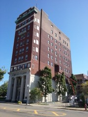
City Savings Bank & Trust Company0.2 miles2016
First Methodist Episcopal Church of Alliance, Ohio0.2 miles1985
Eagles Building--Strand Theater0.2 miles1997
Haines House0.6 miles1974
Earley-Hartzell House0.6 miles1987
Mount Union College District1.4 miles1972

Sources for this property

National Archives recordThe nomination case file for reference 95000940 in Record Group 79.
Wikipedia articleCommunity-written account of this property, licensed CC BY-SA.
Stark CountyAll 81 listed properties in this county.

Provenance

  • Listing record. National Park Service National Register of Historic Places, listed-properties dataset, current to 2026-05-22.
  • Map join. Address geocoded through the United States Census geocoder, then tested against the published boundary of every sheet in the USGS Historical Topographic Map Collection.
  • How this page is made. Listing fields come from federal records; map-sheet coverage is a labelled coordinate-to-boundary calculation, not a source-field claim.
  • Specimens. Global Biodiversity Information Facility (GBIF), https://www.gbif.org/. Only records licensed CC0 or CC BY are used. Records licensed CC BY-NC are excluded because this site carries advertising. Images are checked individually and any whose licence is non-commercial, no-derivatives or unreadable is refused.
  • Mines and quarries. USGS Mineral Resources Data System (MRDS) https://mrdata.usgs.gov/mrds/ A work of the United States government, no copyright under 17 U.S.C. 105.
  • Storms. NOAA National Centers for Environmental Information, Storm Events Database https://www.ncei.noaa.gov/stormevents/ A work of the United States government, no copyright under 17 U.S.C. 105. Narratives are quoted verbatim from the National Weather Service report and are not edited or summarised.