Listed on the National Register of Historic Places in
1975. A historic map-sheet match is not published yet. The record needs a coordinate-quality review before it can be joined to a sheet boundary.
From the record
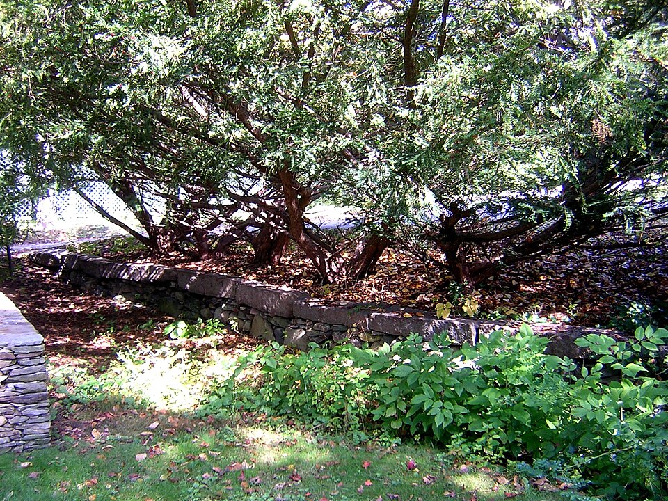
“Thomas Hutchinson's Ha-ha is a historic ha-ha at 100-122 Randolph Avenue in Milton, Massachusetts, United States. Probably built about 1771, it is the only surviving structure of the once-extensive estate of Thomas Hutchinson, the last civilian colonial governor of the British Province of Massachusetts Bay, and one of the few examples of an early ha-ha in North America.”
Wikipedia article Gov. Thomas Hutchinson's Ha-ha, CC BY-SA 4.0.
one of 249 National Register listings in Norfolk County · listed in 1975 · category: Structure · one of 2 National Historic Landmarks in Norfolk County.
National Register reference number.75000290- the number the National Park Service assigned this property when it was listed, and the key its nomination file is catalogued under at the National Archives.
Mr. Hunt was born in Scott's Woods, Milton. He is remembered with great affection as connected with the Sabbath School of the First Evangelical Church in his boyhood. The pastor of this church has followed him with the watchful interest of a sincere friend in his education and progress onward to the place he now occupies.
Since the above date a handsome church edifice has been erected on the Dorchester side, where the shepherd gathers his Milton and Dorchester flock. May the prophetic words come to pass : " There shall they lie in a good fold, and in a fat pasture shall they feed." - Ezekicl xxxiv. 14.
Regional context, not property-specific
evidence. The
federal wildfire occurrence database
lists 168 fires within 5 miles of Hutchinson's, Gov. Thomas, Ha-ha between
2015 and 2020, burning about 110 acres in total. None started naturally. None was recorded as arson.
Distance is straight-line from the map coordinates, so a fire counted
here may appear on a neighbouring settlement's page as well.
Reported cause
Fires
Recreation and ceremony
112
Smoking
31
Missing data/not specified/undetermined
20
Debris and open burning
3
Equipment and vehicle use
2
The most recent of
them, most recent first, with the day each was reported and the service
that recorded it.
Regional context, not property-specific
evidence. Museums hold 12,014 specimens
collected within 10 miles of Hutchinson's, Gov. Thomas, Ha-ha between 1810 and
1975: 4,773 Plantae, 3,648 Fungi, 3,119 Animalia, 204 Protozoa, 174 Chromista, 63 Unrecorded, 33 Bacteria. 12 distinct Species records are shown.
Collected by (MARSDEN, H W), ?, ? ex Herb. W.G. Farlow and others. Each is a
physical object with a catalogue
number, and each entry opens the museum's record. This is what was
collected and kept, not a survey of what lives here - nothing can be
concluded from a species being absent.
Regional context, not property-specific
evidence. The federal mineral resources record lists
3 workings within 5 miles of Hutchinson's, Gov. Thomas, Ha-ha: 1 unknown, 1 past producer, 1 producer.
1 still produces. What was taken out: Stone, Crushed/Broken, Granite. Distance is straight-line from the
map coordinates, so a quarry counted here may appear on a neighbouring
settlement's page as well.
Regional context, not property-specific
evidence. The National Weather Service names
Milton, the town this property stands in, in 21 storm reports between 1996 and 2025: 9 thunderstorm wind, 5 lightning, 4 heavy rain, 1 hail.
The reports record 3 injuries. Each account below is quoted exactly as the forecast office
filed it, from the NOAA Storm Events Database, and each date
opens the federal record of that event.
Lightning struck a house on Augusta Road, causing a fire that engulfed the entire third floor of the house. No one was home at the time of the fire. Three firefighters were hospitalized for heat exhaustion but were released less than 24 hours later.
No historic map-sheet match is published
for this property yet. That does not mean no map exists. This record needs
a coordinate-quality review before it can be joined to a sheet boundary.
Browse the county's mapped places while that work is
pending.
From the nomination file
2,125 words on record
When this property was proposed for the
National Register, someone wrote the case for it: what the building is,
and why it matters. That document is a federal record in the public domain.
It is quoted below word for word, never summarised. The text was read off the scanned case file by machine, so the
occasional stray character is the recogniser's and the 1970s
typewriter's.
Description of the property
Located behind St.Michael's Church an Rando1ph Ave. in Milton, Gov.Hutchinson's Ha-Ha is a stone faced ditch 120' long, 6' wide, and 4' high. The slanted sides of the ha-ha, which are composed of puddingstone and granite rubble, are topped with large cut granite blocks, 5' long, 8"high and l' deep. The ha-ha runs north-south and forms the western boundary of the now deteriorated formal garden. The ha-ha is currently in a state of disrepair; many stones have fallen and it has become congested with debris. Stone steps which descended west to the pasture are located at the southern end of the ha-ha. The garden, which was maintained into the 20th c., measured approximately 320' by 220'and was divided by gravel paths into four sections with a small rear rose garden.
Each section of the garden was enclosed with shrubs and perennials and various hardwoods were placed throughout. While some shrubs and trees still exist, the garden plan is no longer visible and a 20th c. house is located in the middle of the area. With the presence of the house, the garden is unrestorable but plans do exist to restore the ha-ha. The paved drive which runs to the house is located on the natural northern boundary of the ha-ha. BaoDh 0a010E0 ta eashe ste Pre U.n2h 50° 1150 RECEIVED JAN2 81975 NATIONAL REGISTER 8
Statement of significance
/ARCHITECT Gov. Hutchinson's Ha-Ha is significant as the last extant feature (aside from foliage and land) of Gov.Hutchinson's estate, one of the few ha-has visibly extant in New England, and one of the few in the United States. The ha-ha was a very important element in the late 18th and early 19th c. formal garden. Designed, in part, to keep out-wandering cows while not interrupting the view from within the garden, the ha-ha was so named because it was a feature not visible until one was almost upon it, thus the expression of surprise, "ha". In 1771, the year Thomas Hutchinson became Provincial Governor of Massachusetts, Horace Walpole published the most complete description of a "ha-ha" composed up to that point.
In his book, On Modern Gardening, the purpose of the ha-ha was to harmonize the prim regularity of the cultivated portion of the property, the lawn, flower gardens, etc. with the wilder pastures, meadows, deer parks, and cultivated fields outside. Combining them in a general design, "all nature" would thus become a garden. The ha-ha was a most fashionable formal garden feature and it is thought that Gov.Hutchinson constructed the ha-ha shortly after the appearance of Horace Walpole's book. Hutchinson had bought the property in Milton in 1742 and by 1744 had built his "Monticello in Massachusetts". He continually embellished his estate and his love for his garden and knowledge of horticulture were respectfully noted by even his enemy, John Adams.
Hutchinson served as Governor from 1771 to 1774 when he left for England and never returned to America. Thomas Hutchinson was considered to be the most distinguished as well as the most loyal Colonial-born official of his time.
Quoted from the National Register nomination
for reference 75000290, 14 pages, held by the National Archives in Record
Group 79. See the
catalogue record.
Listed places nearby
6 within 8 miles
Other National Register properties close
enough to walk or drive between, ordered by distance from this one. Both
positions come from the same geocoding pass that matched these properties
to their map sheets.
Listing record. National Park Service National Register of Historic Places, listed-properties dataset, current to 2026-05-22.
Map join. Address geocoded through the United States Census geocoder, then tested against the published boundary of every sheet in the USGS Historical Topographic Map Collection.
How this page is made. Listing fields come from federal records; map-sheet coverage is a labelled coordinate-to-boundary calculation, not a source-field claim.
Wildfire. Short, Karen C. 2022. Spatial wildfire occurrence data for the United States, 1992-2020 [FPA_FOD_20221014]. 6th Edition. Fort Collins, CO: Forest Service Research Data Archive. https://doi.org/10.2737/RDS-2013-0009.6 Collected with United States Government funding and usable without additional permissions or fees.
Specimens. Global Biodiversity Information Facility (GBIF), https://www.gbif.org/. Only records licensed CC0 or CC BY are used. Records licensed CC BY-NC are excluded because this site carries advertising. Images are checked individually and any whose licence is non-commercial, no-derivatives or unreadable is refused.
Mines and quarries. USGS Mineral Resources Data System (MRDS) https://mrdata.usgs.gov/mrds/ A work of the United States government, no copyright under 17 U.S.C. 105.
Storms. NOAA National Centers for Environmental Information, Storm Events Database https://www.ncei.noaa.gov/stormevents/ A work of the United States government, no copyright under 17 U.S.C. 105. Narratives are quoted verbatim from the National Weather Service report and are not edited or summarised.
 Block
Block