BlockBefore
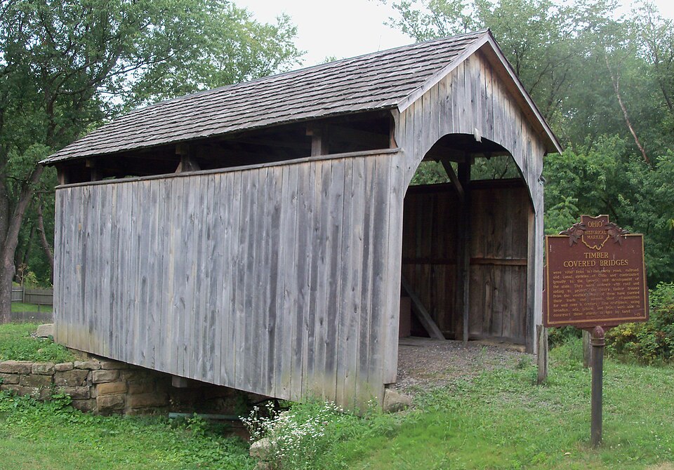
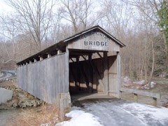
Photograph of Church Hill Road Covered Bridge
Photograph by Roseohioresident, CC BY-SA 3.0. Via Wikimedia Commons.

Church Hill Road Covered Bridge

Listed on the National Register of Historic Places in 1975. A historic map-sheet match is not published yet. The record needs a coordinate-quality review before it can be joined to a sheet boundary.

From the record

“The Church Hill Road Covered Bridge is a covered bridge in Columbiana County, Ohio. It was originally located over Middle Fork Little Beaver Creek in Elk Township.”

Wikipedia article Church Hill Road Covered Bridge, CC BY-SA 4.0.

one of 35 National Register listings in Columbiana County · listed in 1975 · category: Structure · one of 1 National Historic Landmarks in Columbiana County.

Sources: the Wikipedia article · the case file at the National Archives · the National Register database, National Park Service

The listing

  • What is counted as historic. The nomination lists 1 structure as contributing to the listing.
  • Address. 3 mi. E of Lisbon off SR 867, Lisbon, 44432
  • When was it listed? 1975-06-11
  • Category. structure
  • Township. Elkrun township
  • National Register reference number. 75001347 - the number the National Park Service assigned this property when it was listed, and the key its nomination file is catalogued under at the National Archives.

Fires near this property

19 since 2005

Regional context, not property-specific evidence. The federal wildfire occurrence database lists 19 fires within 5 miles of Church Hill Road Covered Bridge between 2005 and 2017, burning about 32 acres in total. None started naturally. None was recorded as arson. Distance is straight-line from the map coordinates, so a fire counted here may appear on a neighbouring settlement's page as well.

Reported cause Fires
Debris and open burning9
Missing data/not specified/undetermined4
Recreation and ceremony4
Smoking2

The most recent of them, most recent first, with the day each was reported and the service that recorded it.

DateCause SizeReported by Name on the report
3 June 2016Smokingunder an acreOhio Department of Natural Resources5006
29 May 2015Recreation and ceremony1.0 acresOhio Department of Natural Resources1741
9 April 2005Debris and open burning5.6 acresOhio Department of Natural Resourcesnot named
5 April 2015Missing data/not specified/undetermined1.0 acresOhio Department of Natural Resources866
18 April 2016Smoking3.0 acresOhio Department of Natural Resources4667
14 April 2005Debris and open burningunder an acreOhio Department of Natural Resourcesnot named
13 April 2015Debris and open burning1.0 acresOhio Department of Natural Resources1721
10 April 2005Missing data/not specified/undeterminedunder an acreOhio Department of Natural Resourcesnot named

Every fire recorded in Columbiana County

Specimens collected near this property

12 of 625 shown

Regional context, not property-specific evidence. Museums hold 625 specimens collected within 10 miles of Church Hill Road Covered Bridge between 1884 and 1975: 379 Animalia, 214 Plantae, 31 Fungi, 1 Unrecorded. 12 distinct Species records are shown. Collected by ?, Adler, K. K., Albert Peyron and others. Each is a physical object with a catalogue number, and each entry opens the museum's record. This is what was collected and kept, not a survey of what lives here - nothing can be concluded from a species being absent.

Image SpeciesYear Collected by Where, as recorded
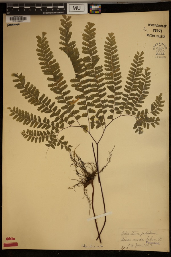
Specimen of Adiantum pedatum L.Adiantum pedatum L.1887?Dense woods, Salem.
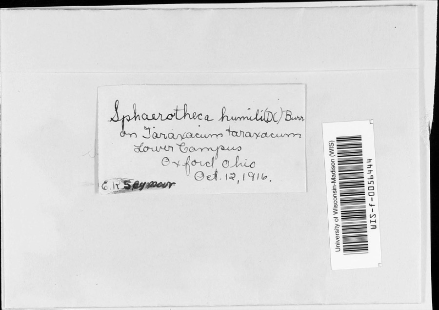
Specimen of Sphaerotheca humuli var. fuliginea (Schltdl.) E.S.SalmonSphaerotheca humuli var. fuliginea (Schltdl.) E.S.Salmon1916E.K. SeymourLower campus
Specimen of Irpiciporus tulipiferae (Schwein.) MurrillIrpiciporus tulipiferae (Schwein.) Murrill1917OverholtsW. Elkton
A photograph of the species Ilex verticillata, not of this specimenIlex verticillata (L.) A.Gray1884Shafer, J.A.near line of Columbiana Co
A photograph of the species Onoclea sensibilis, not of this specimenOnoclea sensibilis L.1884Shafer, J.A.near line of Columbiana County
A photograph of the species Thelypteris palustris, not of this specimenThelypteris palustris var. pubescens (G.Lawson) Fernald1884Shafer, J.A.near line of Columbiana Co
A photograph of the species Chamerion angustifolium, not of this specimenChamerion angustifolium subsp. circumvagum (Mosquin) Hoch1885Shafer, J.A.N.Y.P.U.O.RR, East of Salem
A photograph of the species Micranthes pensylvanica, not of this specimenMicranthes pensylvanica (L.) Haw.1885Shafer, J.A.near line Columbiana Co
A photograph of the species Platanthera lacera, not of this specimenPlatanthera lacera (Michx.) G.Don1885Shafer, J.A.; Hill, W.near Columbiana County line
A photograph of the species Toxicodendron vernix, not of this specimenToxicodendron vernix (L.) Kuntze1885Shafer, J.A.near Columbiana County
A photograph of the species Dryopteris cristata, not of this specimenDryopteris cristata (L.) A.Gray1889Shafer, J.A.near line of Columbiana Co
A photograph of the species Viola L., not of this specimenViola L.1897Holzinger, J.M.Winona County.

All 625 specimens within 10 miles, at the Global Biodiversity Information Facility.

Mines and quarries near this property

3 within 5 miles

Regional context, not property-specific evidence. The federal mineral resources record lists 3 workings within 5 miles of Church Hill Road Covered Bridge: 2 past producers, 1 producer. 1 still produces. What was taken out: Clay, Sand and Gravel, Construction. Distance is straight-line from the map coordinates, so a quarry counted here may appear on a neighbouring settlement's page as well.

Where SiteCommodity StatusRecorded
Adams PitSand and Gravel, ConstructionProducer
Huffman Clay PitClayPast ProducerSedimentary
Huffman Clay PitClayPast Producer

Every working recorded in Columbiana County

Storms near this property

60 of 61 shown

Regional context, not property-specific evidence. The National Weather Service names Lisbon, the town this property stands in, in 61 storm reports between 1993 and 2025: 36 thunderstorm wind, 19 hail, 4 flash flood, 1 tornado. No death or injury is recorded in these reports. Each account below is quoted exactly as the forecast office filed it, from the NOAA Storm Events Database, and each date opens the federal record of that event.

WhenEvent Place namedHarm What the report says
July 2003Flash FloodLisbon$150,000Streams flooded. And a culvert washed out, damaging Route 172, just east of Route 9, about 7 mi west of Lisbon. Courthouse damaged by flooding.
July 1999Thunderstorm WindLisbon$100,000A microburst with winds estimated at around 80 MPH produced damage across the Lisbon area. The microburst produced a path of sporadic wind damage about 1.5 miles in length. The width varied from about 100 feet near the start of the track to nearly 100 yards at the end. The path of the microburst was directed west to east across Ohio SR 30/45 approximately 3.5 miles southeast of Lisbon. One house sustained some structural damage near the roof and second story balcony. A mobile home was lifted from its foundation and several smaller sheds and out-buildings on the property were also damaged or destroyed. In addition, numerous trees and power lines were downed by the microburst winds.
July 2012Thunderstorm WindLisbon$75,000Emergency management reported trees and power lines down, as well as shingles and siding ripped off homes.
June 2008Thunderstorm WindLisbon$75,000Emergency management reported large trees down in Lisbon.
May 2004Thunderstorm WindLisbon$30,00010 camping trailers destroyed by wind. Hundreds of trees down countywide.
June 2011Thunderstorm WindLisbon$25,000Department of transportation reported trees down near Lisbon.
May 2022Thunderstorm WindLisbon$10,000Trees were reported to be blown down.
March 2008FloodLisbon$10,000Emergency management reported streets flooded in Lisbon.
April 2014Thunderstorm WindLisbon$5,000A trained spotter reported a very large pine tree down on Route 45 blocking the southbound lane.
July 2011Thunderstorm WindLisbon$5,000Emergency management reports trees down on Route 517 in Lisbon.
April 2005Thunderstorm WindLisbon$5,000Trees blown down at intersection of Rtes 30 and 45. Several other trees down in the townships of Hanover and Liverpool.
June 2005Thunderstorm WindLisbon$5,000Trees and power lines down, on Rte 164, just south of Lisbon.
June 2015Thunderstorm WindLisbon$4,000A trained spotter reported numerous large trees snapped.
May 2006Thunderstorm WindLisbon$4,000Trees blown down on Rte 164.
June 2022Thunderstorm WindLisbon$3,000Broadcast media reported power lines down on East Washington Street and other streets in Lisbon, OH.
June 2015Thunderstorm WindLisbon$3,000Law enforcement reported trees down.
July 1999Thunderstorm WindLisbon$3,000Thunderstorm winds downed several trees.
July 1999Thunderstorm WindLisbon$3,000Thunderstorm winds downed several large trees.
June 1998Thunderstorm WindLisbon$3,000Thunderstorm winds blew down three large trees.
July 1998Thunderstorm WindLisbon$3,000no account filed
April 2019Thunderstorm WindLisbon$2,000County 911 officials reported that numerous trees were blown down near Lisbon.
November 2017Thunderstorm WindLisbon$2,000Local law enforcement reported several trees down.
April 2003Thunderstorm WindLisbon$2,000Trees down.
June 2002Thunderstorm WindLisbon$2,000Thunderstorm winds downed a few large trees and power lines.
August 2001Thunderstorm WindLisbon$2,000Thunderstorm winds downed a few trees.
July 2000Thunderstorm WindLisbon$2,000Thunderstorm winds downed a few trees.
August 1998Thunderstorm WindLisbon$2,000Thunderstorm winds downed a few trees.
June 1995TornadoLisbon$2,000A brief tornado (F0) touched down briefly near the intersection of Routes 45 and 517 on the northwest side of Lisbon. The tornado was approximated 15 yards wide and was on the ground for about a tenth of a mile. The only associated damage was a few downed trees and three pieces of aluminum siding ripped from the side of a nearby home.
July 2019Flash FloodLisbon$1,000A trained spotter reported flooding around Lee Avenue and Race Road.
May 2003Thunderstorm WindLisbon$1,000Large tree limbs and power lines down.
June 1998Thunderstorm WindLisbon$1,000Thunderstorm winds blew a tree down across Echodale Road.
June 1995Thunderstorm WindLisbon$1,000Power lines downed by thunderstorm winds.
June 1995Thunderstorm WindLisbon$1,000thunderstorm winds.
August 2012Thunderstorm WindLisbon$500State official reported multiple trees down and power outages.
May 1993HailLisbon$500no account filed
March 2025Thunderstorm WindLisbon-Downed trees and power lines were reported in the area of Lisbon.
July 2025Thunderstorm WindLisbon-Report of multiple wires down in the area.
August 2023Thunderstorm WindLisbon-Large trees down.
June 2021Thunderstorm WindLisbon-Wires down on Black Road in Center Township.
May 2018Thunderstorm WindLisbon-Trees down on Steubenville Pike and Black Road in Lisbon.
April 2015HailLisbon-The public reported silver dollar sized hail.
June 2007HailLisbon-Quarter size hail was reported by a trained spotter in the East Rochester area.
August 2007HailLisbon-A HAM radio operator reported nickel sized hail in Lisbon.
June 2007Thunderstorm WindLisbon-Trees reported down along Rt. 518.
June 2004Flash FloodLisbon-Logtown Rd flooded.
June 1998Flash FloodLisbon-Thunderstorm rains produced minor flooding on US Route 30.
June 1995HailLisbon-Power lines downed by thunderstorm winds.
March 2024HailLisbon-no account filed
May 2018HailLisbon-no account filed
July 2013HailLisbon-no account filed
June 2013HailLisbon-no account filed
May 2011HailLisbon-no account filed
March 2011HailLisbon-no account filed
May 2011HailLisbon-no account filed
March 2010HailLisbon-no account filed
May 2010HailLisbon-no account filed
June 2005HailLisbon-no account filed
April 2002HailLisbon-no account filed
July 1996HailLisbon-no account filed
April 1996HailLisbon-no account filed

Every storm recorded in Columbiana County

Map coverage status

No historic map-sheet match is published for this property yet. That does not mean no map exists. This record needs a coordinate-quality review before it can be joined to a sheet boundary. Browse the county's mapped places while that work is pending.

From the nomination file

4,452 words on record

When this property was proposed for the National Register, someone wrote the case for it: what the building is, and why it matters. That document is a federal record in the public domain. It is reproduced in full on its own page, word for word and never summarised. The text was read off the scanned case file by machine, so the occasional stray character is the recogniser's and the 1970s typewriter's.

The whole case file for this property - 4,452 words, 33 pages, reproduced complete.

Quoted from the National Register nomination for reference 75001347, 33 pages, held by the National Archives in Record Group 79. See the catalogue record.

Listed places nearby

6 within 8 miles

Other National Register properties close enough to walk or drive between, ordered by distance from this one. Both positions come from the same geocoding pass that matched these properties to their map sheets.

Photograph PropertyDistance Listed
Hanna--Kenty House2.1 miles2001
Eckis, Nicholas, House5.3 miles1980
Columbiana County Infirmary5.5 miles1979
Teegarden--Centennial Covered Bridge5.9 miles2000
Morgan, John H., Surrender Site6.3 miles1973
Schmick, Charles Nelson, House6.7 miles1991

Sources for this property

National Archives recordThe nomination case file for reference 75001347 in Record Group 79.
Wikipedia articleCommunity-written account of this property, licensed CC BY-SA.
Columbiana CountyAll 35 listed properties in this county.

Provenance

  • Listing record. National Park Service National Register of Historic Places, listed-properties dataset, current to 2026-05-22.
  • Map join. Address geocoded through the United States Census geocoder, then tested against the published boundary of every sheet in the USGS Historical Topographic Map Collection.
  • How this page is made. Listing fields come from federal records; map-sheet coverage is a labelled coordinate-to-boundary calculation, not a source-field claim.
  • Wildfire. Short, Karen C. 2022. Spatial wildfire occurrence data for the United States, 1992-2020 [FPA_FOD_20221014]. 6th Edition. Fort Collins, CO: Forest Service Research Data Archive. https://doi.org/10.2737/RDS-2013-0009.6 Collected with United States Government funding and usable without additional permissions or fees.
  • Specimens. Global Biodiversity Information Facility (GBIF), https://www.gbif.org/. Only records licensed CC0 or CC BY are used. Records licensed CC BY-NC are excluded because this site carries advertising. Images are checked individually and any whose licence is non-commercial, no-derivatives or unreadable is refused.
  • Mines and quarries. USGS Mineral Resources Data System (MRDS) https://mrdata.usgs.gov/mrds/ A work of the United States government, no copyright under 17 U.S.C. 105.
  • Storms. NOAA National Centers for Environmental Information, Storm Events Database https://www.ncei.noaa.gov/stormevents/ A work of the United States government, no copyright under 17 U.S.C. 105. Narratives are quoted verbatim from the National Weather Service report and are not edited or summarised.