




BlockBefore
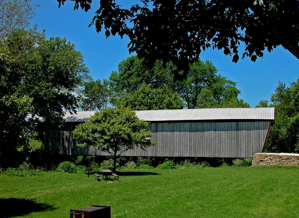
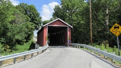
Photograph of Lynchburg Covered Bridge
Photograph by dok1, CC BY 2.0. Via Wikimedia Commons.

Lynchburg Covered Bridge

Listed on the National Register of Historic Places in 1976. A historic map-sheet match is not published yet. The record needs a coordinate-quality review before it can be joined to a sheet boundary.

From the record

“The Lynchburg Covered Bridge is a historic wooden covered bridge that spans the east fork of the Little Miami River in Lynchburg, Ohio. It also has the distinction, following a recent repair and restoration project, of being the only such covered bridge in North America to have been converted to a pseudo-suspension infrastructure.”

Wikipedia article Lynchburg Covered Bridge, CC BY-SA 4.0.

one of 11 National Register listings in Clinton County · listed in 1976 · category: Structure.

Sources: the Wikipedia article · the case file at the National Archives · the National Register database, National Park Service

The listing

  • What is counted as historic. The nomination lists 1 structure as contributing to the listing.
  • Address. East Fork of Little Miami River, Lynchburg, 45142
  • When was it listed? 1976-03-16
  • Category. structure
  • Township. Clark township
  • National Register reference number. 76001456 - the number the National Park Service assigned this property when it was listed, and the key its nomination file is catalogued under at the National Archives.

The ground it stands on

7,004 words

The chapter on Clark Township in The History of Clinton County, Ohio : Containing a History of the County; Its Townships, Cities, Towns ... General and Local Statistics; Portraits of Early Settlers and Prominent Men; History of the Northwest Territory; History of Ohio .., published 1915 names Lynchburg. This is what it says, exactly as the scans read.

Tradition has It thnt Thomas Johns was the first to settle within the present bounds of Clark township. He is said to have located on the Bast fork, about three miles southenHt of the present site of Martinsville. Nothing about the place of bis birth or of the date of his settlement can be ascertained. However, it Is known that Isaac Miller settled about three miles east of Martinsville. The story is told that Mr. Miller, needing a hoe. Journeyed sixteen miles on foot through the forests to New Market In Highland county to make his purchase. Joseph McKibben also settled about the same time In the same neighborhood. In 1806. John Wright came from North Carolina, bought the present site of Martinsville, for two dollars an acre, and settled there. He was mainly Instrumental in the laylng-out of that village and erected the first bouse within Its limits. A daughter of bis was the first person to be Interred In the Friend's graveyard at Martinsville. By the year 1808, Samuel McCulloch had settled on East fork, four miles southeast of Martinsville, and Isaac Van Meter and John Jones near the present site of Lynchburg.

Passage source: The History of Clinton County, Ohio : Containing a History of the County; Its Townships, Cities, Towns ... General and Local Statistics; Portraits of Early Settlers and Prominent Men; History of the Northwest Territory; History of Ohio .., published 1915.

In the first days of the settlement the meal for bread for tbe community was ground on a hand-mill owned by Joseph Moon. Sr. A short time afterwards. Isaac Nordyke built a borse-mlll five or six miles away from the Martinsville settlement. The next opportunities were to take two or three bushels of grnln on horseback to the mill on Cowan's creek or the East fork. When the water was too low for these mills to operate, a Journey of three or four days was required to reach the mills on the Miami. The first mill to be built within tbe confines of the township was a saw and grist-mill built by William Leagitt on the East fork, followed by Isaac Jones, near Lynchburg, and the third was built by Aaron Ruse on the same stream, between Leagitt's and Jones'. William Patterson built tbe fourth mill in tbe township on tbe East fork of Todd's fork, half a mile northwest of Martinsville. A cardlng-mlll. run by oxen on an Inclined wheel, was built about 1827. by Christopher Hiatt. John Lytle later erected another cardingmachine near tbe present site of Martinsville, as did also Curtis Jackson. The first mill within tbe township to use steam power was built about a mile west of that town In 1833 or 1834. Isaac Pidgeon applied steam to a carding and fulling machine, to which he attached apparatus for grinding corn a short time later. Two other steam-mills were built later - one known as Kester's. about two miles northeast of Martinsville, which was removed several years later to Farmer's Station: the other, in Martinsville, built with money raised by subscription for that purpose. The mill was built and operated for a while by Angus McCoy and Daniel Carey. This mill was destroyed by fire about the year 1860, while owned by Jehu Darls. who erected another building.

Passage source: The History of Clinton County, Ohio : Containing a History of the County; Its Townships, Cities, Towns ... General and Local Statistics; Portraits of Early Settlers and Prominent Men; History of the Northwest Territory; History of Ohio .., published 1915.

Machine-read from a century-old scan, so expect the errors a machine makes: misspelled names, dropped words, stray characters.

Read the whole chapter on Clark Township - 7,004 words on its settlement, mills, schools and churches.

Specimens collected near this property

12 of 100 shown

Regional context, not property-specific evidence. Museums hold 100 specimens collected within 10 miles of Lynchburg Covered Bridge between 1923 and 1969: 84 Animalia, 15 Plantae, 1 Fungi. 12 distinct Species records are shown. Collected by Braun, E. Lucy, Bruce Menzel; F. Menzel, C CROFT and others. Each is a physical object with a catalogue number, and each entry opens the museum's record. This is what was collected and kept, not a survey of what lives here - nothing can be concluded from a species being absent.

Image SpeciesYear Collected by Where, as recorded
A photograph of the species Cladonia coniocraea, not of this specimenCladonia coniocraea (Flörke) Spreng.1923Braun, E. LucyKlock's Crossing
A photograph of the species Catharinea undulata, not of this specimenCatharinea undulata (Hedw.) F.Weber & D.Mohr1930Fulford, Margaret H.North of Westboro
A photograph of the species Helodium paludosum, not of this specimenHelodium paludosum (Austin) Austin ex Broth.1930Fulford, Margaretnorth of Westboro
A photograph of the species Plagiothecium denticulatum, not of this specimenPlagiothecium denticulatum (Hedw.) Schimp.1930Fulford, Margaretnorth of Westboro
A photograph of the species Polytrichum ohioense, not of this specimenPolytrichum ohioense Renauld & Cardot1930Fulford, Margaretnorth of Westboro
A photograph of the species Ericymba buccata, not of this specimenEricymba buccata Cope, 18651938Rhoades, R. (Randall)Turtle Creek, within Dodson township, near Lynchburg, Dodson township
A photograph of the species Etheostoma blennioides, not of this specimenEtheostoma blennioides blennioides Rafinesque, 18191938Rhoades, R. (Randall)Turtle Creek, south of Lynchburg, ~0.4 mi SE of Lynchburg, Dodson township
A photograph of the species Etheostoma flabellare, not of this specimenEtheostoma flabellare Rafinesque, 18191938Rhoades, R. (Randall)Turtle Creek, within Dodson township, near Lynchburg, Dodson township
Labidesthes sicculus (Cope, 1865)1938Rhoades, R. (Randall)Westboro Reservoir, Jefferson township, 0.6 mi W of Westboro, Jefferson township
A photograph of the species Lepomis cyanellus, not of this specimenLepomis cyanellus Rafinesque, 18191938Rhoades, R. (Randall)Westboro Reservoir, Jefferson township, 0.6 mi W of Westboro, Jefferson township
Lepomis macrochirus Rafinesque, 18191938Rhoades, R. (Randall)Westboro Reservoir, Jefferson township, 0.6 mi W of Westboro, Jefferson township
Notropis cornutus chrysocephalus (Rafinesque, 1820)1938Rhoades, R. (Randall)Turtle Creek, within Dodson township, near Lynchburg, Dodson township

All 100 specimens within 10 miles, at the Global Biodiversity Information Facility.

Map coverage status

No historic map-sheet match is published for this property yet. That does not mean no map exists. This record needs a coordinate-quality review before it can be joined to a sheet boundary. Browse the county's mapped places while that work is pending.

From the nomination file

1,563 words on record

When this property was proposed for the National Register, someone wrote the case for it: what the building is, and why it matters. That document is a federal record in the public domain. It is quoted below word for word, never summarised. The text was read off the scanned case file by machine, so the occasional stray character is the recogniser's and the 1970s typewriter's.

Description of the property

portals, a metal roof(much missing), vertical, high-boarded siding, and Of damage to the roof and rafters in a windstorm in February 1974. Much CONDITION UNEXPOSED RUINS EXCELLENT GOOD FAIR XDETERIORATED traffic until repairs are made. considered to be the first panel truss and the first truss into which CHECK ONE counterbraces in the form of an X between wooden verticals. and there is no lean to the structure.The bridge is closed to all cut-stone abutments. lengthwise and resting on 11" x 3" joists. bridge about 1o' out from each abutment. The floor is one layer, laid 2 3/4".

The upper chords are 3-11" x 5k" and the lower chords are 1- The structure under consideration is a one-span wooden truss covered mathematical calculations entered.The Lynchburg Bridge is a lo panel The condition of the Lgmchburg Bridge is not good at this time because siding is also gone.The trusses of the bridge seem sturdy, however, The roadway width is 16'5" and the overall width of the structure is John C. Gregg of Hillsboro, Ohio,using the Long truss plan.This truss was patented in 1830 by Col.Stephan H. Long of the U.S. Army Topo- AREAS OF
Statement of significance

No repair work has been done as yet. being one of only eight Long trusses left in Ohio, it is our only 1500-1599 1870 INVENTION ART EDUCATION COMMERCE ARCHEOLOGY-HISTORIC PERIOD THEATER BUILDER/ARCHITECT AGRICULTURE ARCHITECTURE LAW MILITARY SIGNIFICANCE Historic 1900- second century.

SCULPTURE INDUSTRY cided to close to bridge to pedestrian traffic until repairs could be _POLITICS/GOVERNMENT EXPLORATION/SETTLEMENT Historic Landmarks was formed at this time with the intention of taking the Lynchburg Bridge still stands sturdy and straight as it enters its County line and construction and maintenance costs were shared equally _COMMUNICATIONS steel structure a few hundred yards down stream and the fight began to _TRANSPORTATION _PHILOSOPHY _SOCIAL/HUMANITARIAN The bridge takes its name from the village of Lynchburg which in turn, was named by its early settlers for their home of Lynchburg, Virginia.

X.ENGINEERING -1600-1699 _CONSERVATION -SCIENCE -1800-1899 -1400-1499 _ECONOMICS one of the few village bridges left here in Ohio and one of only three _RELIGION -MUSIC -_1700-1799 There was an Indian encampment here as covered bridges in the Highland-Clinton County areas. In addition to However, ownership of the bridge still rests with the two counties and inter-county covered bridge.Despite the heavy damage to its nothing has been done about a park at the site.At the time it was by- of February l974 damaged the roof structure so badly that it was de- The Lynchburg Bridge was built in l870 by John C. Gregg of Hillsboro late as 18o6 and there was a battle nearby between Simon Kenton and by the two counties.In l969,the old bridge was by-passed by a new Lynchburg is an historic area.

The whole case file for this property - 1,563 words, 12 pages, reproduced complete.

Quoted from the National Register nomination for reference 76001456, 12 pages, held by the National Archives in Record Group 79. See the catalogue record.

Listed places nearby

1 within 8 miles

Other National Register properties close enough to walk or drive between, ordered by distance from this one. Both positions come from the same geocoding pass that matched these properties to their map sheets.

Photograph PropertyDistance Listed
Martinsville Road Covered Bridge6.2 miles1974

Sources for this property

National Archives recordThe nomination case file for reference 76001456 in Record Group 79.
Wikipedia articleCommunity-written account of this property, licensed CC BY-SA.
Clinton CountyAll 11 listed properties in this county.

Provenance

  • Listing record. National Park Service National Register of Historic Places, listed-properties dataset, current to 2026-05-22.
  • Map join. Address geocoded through the United States Census geocoder, then tested against the published boundary of every sheet in the USGS Historical Topographic Map Collection.
  • How this page is made. Listing fields come from federal records; map-sheet coverage is a labelled coordinate-to-boundary calculation, not a source-field claim.
  • Specimens. Global Biodiversity Information Facility (GBIF), https://www.gbif.org/. Only records licensed CC0 or CC BY are used. Records licensed CC BY-NC are excluded because this site carries advertising. Images are checked individually and any whose licence is non-commercial, no-derivatives or unreadable is refused.