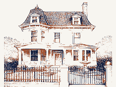
A National Historic Landmark. Listed on the National Register of Historic Places in
1976. A historic map-sheet match is not published yet. The record needs a coordinate-quality review before it can be joined to a sheet boundary.
From the record
“(VII) Daniel Smith Gray, son of Timothy Gray (6), born in Wilton, New Hampshire, October 6, 1816, died October 9, 1900, at Lowell. He attended the district schools of his native town, and remained at home working on his father's farm until he was about twenty years of age.”
Historic Homes and Places and Genealogical and Personal Memoirs Relating to the Families of Middlesex County, Massachusetts ; (1908). Machine-read text.
one of 1100 National Register listings in Middlesex County · listed in 1976 · category: Building · one of 3 National Historic Landmarks in Middlesex County.
National Register reference number.76001972- the number the National Park Service assigned this property when it was listed, and the key its nomination file is catalogued under at the National Archives.
It appears that immediately after ilr. Lowell's return he had at once gone to work to construct a loom ; but he found its construction no easy task. Without patterns, or even drawings, so far as we know, each part had to be planned and tried, altered and rearranged, until tlie whole assumed the shape of a machine. We are told that " many little matters were to be overcome or adjusted before it would work perfectly." Mr. Appleton says : " Mr. Lowell said to me that he did not wish me to see it until it was complete, of whicli he would give me notice. At length the time arrived. He invited me to go out with him and see the loom operate. I well recollect the state of admiration and satisfaction with which we sat by the hour watching the beautiful movement of this new and wonderful machine, destined, as it evidently was, to change the character of all textile industry. This was in the autumn of 1814."
The great obstacle to tlie use of the power-loom, at that time, proved to be dressing the yarn ; it required a man at each loom to dress the warp as it unrolled from the beam. This rendered it necessary to stop the loom while the man was doing it. This difficulty was removed by the invention of an ingenious mode of dressing the warp before it was placed in the loom. Mr. Lowell procured from England a drawing of Horrocks' dressing-frame, and Mr. Moody, whose services he had secured, made an improvement which more than doubled its efficiency, - a very ingenious machine called a warper, that wound the threads from the bobbins on the beam. After this there was no farther difficulty in running a power-loom.
Regional context, not property-specific
evidence. The
federal wildfire occurrence database
lists 133 fires within 5 miles of Hamilton Manufacturing Company Countinghouse between
2001 and 2020, burning about 75 acres in total. 3 started naturally. 30 were recorded as arson.
Distance is straight-line from the map coordinates, so a fire counted
here may appear on a neighbouring settlement's page as well.
Reported cause
Fires
Missing data/not specified/undetermined
36
Arson/incendiarism
30
Debris and open burning
27
Recreation and ceremony
20
Equipment and vehicle use
4
Smoking
4
Misuse of fire by a minor
3
Power generation/transmission/distribution
3
Natural
3
Railroad operations and maintenance
2
Other causes
1
The most recent of
them, most recent first, with the day each was reported and the service
that recorded it.
Regional context, not property-specific
evidence. Museums hold 552 specimens
collected within 10 miles of Hamilton Manufacturing Company Countinghouse between 1898 and
1975: 359 Plantae, 125 Animalia, 35 Fungi, 29 Protozoa, 3 Chromista, 1 Unrecorded. 12 distinct Species records are shown.
Collected by A. C. Mathieson, A. F. Newton, A. F. Newton, M. K. Thayer and others. Each is a
physical object with a catalogue
number, and each entry opens the museum's record. This is what was
collected and kept, not a survey of what lives here - nothing can be
concluded from a species being absent.
Regional context, not property-specific
evidence. The federal mineral resources record lists
22 workings within 5 miles of Hamilton Manufacturing Company Countinghouse: 10 past producers, 7 producers, 4 plants, 1 unknown.
11 still produce. What was taken out: Sand and Gravel, Construction, Stone, Crushed/Broken, Graphite, Nickel, Gold, Silver, Copper. Distance is straight-line from the
map coordinates, so a quarry counted here may appear on a neighbouring
settlement's page as well.
Regional context, not property-specific
evidence. The National Weather Service names
Lowell, the town this property stands in, in 16 storm reports between 1995 and 2023: 6 thunderstorm wind, 4 flood, 3 lightning, 2 hail.
The reports record 2 injuries. Each account below is quoted exactly as the forecast office
filed it, from the NOAA Storm Events Database, and each date
opens the federal record of that event.
No historic map-sheet match is published
for this property yet. That does not mean no map exists. This record needs
a coordinate-quality review before it can be joined to a sheet boundary.
Browse the county's mapped places while that work is
pending.
From the nomination file
9,890 words on record
When this property was proposed for the
National Register, someone wrote the case for it: what the building is,
and why it matters. That document is a federal record in the public domain.
It is quoted below word for word, never summarised. The text was read off the scanned case file by machine, so the
occasional stray character is the recogniser's and the 1970s
typewriter's.
Description of the property
The Iocks and Canals Historic District encompasses all of the canals in Lowell, (built between 1793 and 1848), their associated locks, and the mills that were powered by the canals. There are about five miles of canals, and the associated mill yards increase the acreage of the nominated district to approximately 100 acres. The canals are all contiguous though they meander throughout the city. The mill buildings and yards are all associated directly with a canal, and three boarding houses, not contiguous to the canals but built by mill owners for their workers, are also included in the district. The Pawtucket Canal, the first canal to be built in Iowel1, leaves the Merrimack River a few hundred yards apstream from the Pawtucket Dam.
The site of the guard locks, about 2,000 feet from the head of the canal, has been inn continuous use since the canal was opened to navigation in 1796, and the present structures and facilities include the Francis . to navigat2on in 17%, a Gate, a lock house and a sluice gate house. The Francis Gate (#2) also known locally as Francis' Folly, is aproticullis flood gate, bullt in 1848-1850. The lock house (#1), built in 1881 over the upstream gate of the locking chamber, replaced an earlier 1852 structure. It is a wwoden frame building with round arched windows and a slate hipped roof. The gluice gate house (#3) built in 1870, is a brick Romanesque structure with round arched windows and a slate ridge roof, containing machinery for five gates.
Ma- sonry work around the Guard Iocks includes the lower part of the dam (1832), the upper dam portion (1848), the walls of the upstream island and lock chamber (1801) and downstream lock chamber.
/ARCHITECT STATEMENT OF SIGNIFICANCE The Locks and Canals Historic District in Iowell is significant for its contributions to the development of Iowell as the first great industrial city in the United States. The industrial revolution in North America was first initiated on a large scale in Lowell, and our industrial economy and present levels of technology are a feflectiog of Lowell's manufacturing experiments. TJ:J In 1792 Governor John Hancock signed a charter incorporating the Proprietors of the locks and Canals on the Merrimack River. The charter gave to this group of Newburyport merchants tiparian rights on the Merrimack River from the Massachusetts border to the Atlantic Ocean, and more specifically, the right to build locks and a canal to circumvent the Pawtucket Falls.
This canal, opened in 1796, formed an island between itself and the Merrimack River, where the City of Lowell later developed. The canal was used to transport lumber, foodstuffs and people around the Pawtucket Falls on their journey from New Hampshire to Newburyport. In 1803 the Middlesex Canal opened, funnelling off to Boston the traffic which had been going to Newburyport, and caused the Pawtucket Canal to fail financially. In 1822 the Merrimack Manufactüring Company, founded by Patrick Tracy Jackson and Nathan Appleton, bought up the holdings of the Proprietors and all of the land between the Merri- mack River and the Pawtucket Canal.
Both Jackson and Appleton had been partners of Francis Cabot Iowe11 in his successful mill at Waltham, Massachusetts where, for the first time, otton was processed 'into cloth within a single building. At the Waltham mill Francis Iowe11 had developed the system of boarding houses and strict social regulation, which brought New England farm girls into the mills and had such an impact on the early days of the American indistrial revolution.
Quoted from the National Register nomination
for reference 76001972, 38 pages, held by the National Archives in Record
Group 79. See the
catalogue record.
Listed places nearby
6 within 8 miles
Other National Register properties close
enough to walk or drive between, ordered by distance from this one. Both
positions come from the same geocoding pass that matched these properties
to their map sheets.
Listing record. National Park Service National Register of Historic Places, listed-properties dataset, current to 2026-05-22.
Map join. Address geocoded through the United States Census geocoder, then tested against the published boundary of every sheet in the USGS Historical Topographic Map Collection.
How this page is made. Listing fields come from federal records; map-sheet coverage is a labelled coordinate-to-boundary calculation, not a source-field claim.
Wildfire. Short, Karen C. 2022. Spatial wildfire occurrence data for the United States, 1992-2020 [FPA_FOD_20221014]. 6th Edition. Fort Collins, CO: Forest Service Research Data Archive. https://doi.org/10.2737/RDS-2013-0009.6 Collected with United States Government funding and usable without additional permissions or fees.
Specimens. Global Biodiversity Information Facility (GBIF), https://www.gbif.org/. Only records licensed CC0 or CC BY are used. Records licensed CC BY-NC are excluded because this site carries advertising. Images are checked individually and any whose licence is non-commercial, no-derivatives or unreadable is refused.
Mines and quarries. USGS Mineral Resources Data System (MRDS) https://mrdata.usgs.gov/mrds/ A work of the United States government, no copyright under 17 U.S.C. 105.
Storms. NOAA National Centers for Environmental Information, Storm Events Database https://www.ncei.noaa.gov/stormevents/ A work of the United States government, no copyright under 17 U.S.C. 105. Narratives are quoted verbatim from the National Weather Service report and are not edited or summarised.
 Block
Block