Listed on the National Register of Historic Places in
1977. A historic map-sheet match is not published yet. The record needs a coordinate-quality review before it can be joined to a sheet boundary.
From the record
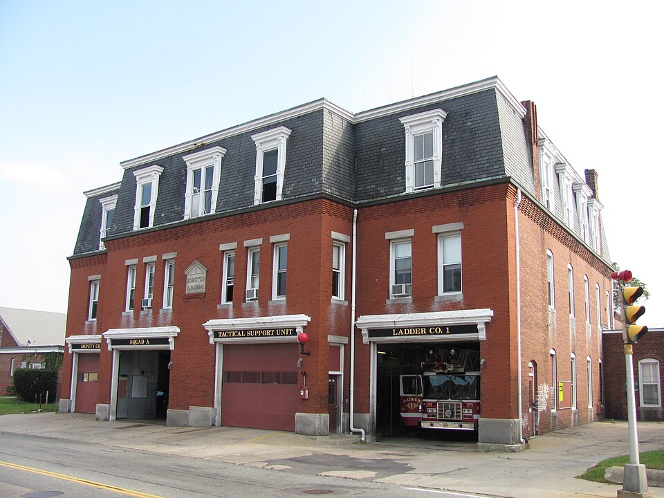
“The Central Fire Station is a historic fire station on 40 Pleasant Street in Brockton, Massachusetts. Built in 1884-85, the three-story brick mansard-roofed Second Empire building included several "firsts".”
Wikipedia article Central Fire Station (Brockton, Massachusetts), CC BY-SA 4.0.
one of 93 National Register listings in Plymouth County · listed in 1977 · category: Building · one of 1 National Historic Landmarks in Plymouth County.
Architectural style. Second Empire architecture in the United States and Canada
Architect. Waldo V. Howard
National Register reference number.77000193- the number the National Park Service assigned this property when it was listed, and the key its nomination file is catalogued under at the National Archives.
The history of Brockton has been written, and is at last presented to the public, after an unexpected amount of labor. There is no. locality in New England which has undergone more rapid changes than this. In ISOO the auth(ir wrote an extended histor)' of the town of North Bridgewater, which has long since gone out of print, containing then about six thousand inhabitants. The rapid growth of the town, the change (jf name t(j Brockton, and afterwards its incorporation into a city, rendered the necessity for a new and enlarged naiTative work under the distinctive name of Brockton. The work has been subject to unavoidable delay owing to the extra amount of work in its preparation, and it is submitted to the citizens of Brockton and vicinity, with all its imperfections, with the hope that it may not be disappointing to those who are interested in and have by their encouragement and generous subscriptions been the means of its publication. Of the importance of works of this class, we may be pardoned for quoting from an eminent writer on kindred works: *
The undersigned citizens and legal voters in the town of North Bridgewater, while willing or desirous to change the corporate name of the town, respectfully beg leave to protest against adopting the name of Brockton, and ask to be heard by themselves or counsel thereon.
Regional context, not property-specific
evidence. The
federal wildfire occurrence database
lists 421 fires within 5 miles of Central Fire Station between
2005 and 2020, burning about 179 acres in total. 5 started naturally. 8 were recorded as arson.
Distance is straight-line from the map coordinates, so a fire counted
here may appear on a neighbouring settlement's page as well.
Reported cause
Fires
Debris and open burning
211
Missing data/not specified/undetermined
133
Misuse of fire by a minor
30
Recreation and ceremony
17
Smoking
16
Arson/incendiarism
8
Natural
5
Fireworks
1
The most recent of
them, most recent first, with the day each was reported and the service
that recorded it.
Regional context, not property-specific
evidence. Museums hold 793 specimens
collected within 10 miles of Central Fire Station between 1857 and
1975: 441 Plantae, 216 Fungi, 133 Animalia, 1 Chromista, 1 Protozoa, 1 Unrecorded. 12 distinct Species records are shown.
Collected by A. A. Eaton, A. B. Seymour, A. Clark and others. Each is a
physical object with a catalogue
number, and each entry opens the museum's record. This is what was
collected and kept, not a survey of what lives here - nothing can be
concluded from a species being absent.
Regional context, not property-specific
evidence. The federal mineral resources record lists
11 workings within 5 miles of Central Fire Station: 9 past producers, 1 producer, 1 plant.
2 still produce. What was taken out: Sand and Gravel, Construction, Stone, Crushed/Broken. Distance is straight-line from the
map coordinates, so a quarry counted here may appear on a neighbouring
settlement's page as well.
Regional context, not property-specific
evidence. The National Weather Service names
Brockton, the town this property stands in, in 26 storm reports between 1994 and 2023: 8 thunderstorm wind, 8 hail, 3 heavy rain, 3 lightning.
The reports record 60 injuries. Each account below is quoted exactly as the forecast office
filed it, from the NOAA Storm Events Database, and each date
opens the federal record of that event.
Numerous trees and wires were downed by thunderstorm winds throughout Brockton. This includes trees and wires on Warren Avenue in front of the Boys and Girls Club, near the high school, on Route 14, on French and Perkins Avenues, and on Ash Street. One of these trees fell on a dentists office on South Street in the Campello neighborhood.
A line of thunderstorms moved across parts of central and eastern Massachusetts with wind gusts to 40 to 50 mph. In Lowell, two children received minor injuries when a tree fell on them after it was uprooted by winds gusting to an estimated 50 mph. In Southboro, large tree limbs were downed. In Swampscott, a tree fell on an automobile. In Belmont, Cambridge, and Watertown, tree limbs and a few power lines were reported blown down. In Brockton, two large tree limbs were knocked down. In downtown Boston, a street sign was blown down and hit a man on the head.
No historic map-sheet match is published
for this property yet. That does not mean no map exists. This record needs
a coordinate-quality review before it can be joined to a sheet boundary.
Browse the county's mapped places while that work is
pending.
From the nomination file
2,322 words on record
When this property was proposed for the
National Register, someone wrote the case for it: what the building is,
and why it matters. That document is a federal record in the public domain.
It is quoted below word for word, never summarised. The text was read off the scanned case file by machine, so the
occasional stray character is the recogniser's and the 1970s
typewriter's.
Description of the property
Central Fire Station is located on Pleasant Street in downtown Brockton in a mixed commercial/residential area. The exterior of the building has changed little since its construction in 1884. The 3 story, Mansard roof structure is of red brick with a granite foundation. Fenestration is tall narrow windows of either 1/1 or 2/2. A corbelled brick table encircles the building beneath the slate roof. The symmetrical facade faces north toward Pleasant Street. It is dominated by a central projecting pavilion; the first story of this is dominated by two engine bays whose 5x6 panel wooden doors are painted green and white. The second and third hori- zontal bands of panels at the top of the doors are glass. The doors are topped by a plain frieze and molded cornice supported by end brackets.
Above each door is a TAS OV Cater dEOs igdo group of 3 half windows with granite lintels and sills. At the center of these window groupings is a raised granite plaque noting the date of the building's erection. The third story has three decorative dormers painted green. The center dormer is composed of paired 1/1 windows. This is flanked by the 2/2 window dormers on either side. A11 three are framed by molded architraves and headed by a wide, projecting, molded en- tablature. The narrow east and west elevations of the pavillion each contain a tall wooden door headed by a 2/2 window on the second story. Flanking the center pavillion is the main body of the building. Both the eastern and western facade ends have an engine bay identical to those in the projection.
These bays are topped by two 2/2 windows on the second story and by a single 2/2 dormer win- dow in the roof.
/ARCHITECT waldo V. Howard Brockton's Central Fire Station is significant for a technological achievement and as a well preserved and maintained example of the Second Empire Style of architecture. Although it cannot be described as a high style example of Second Empire architecture, it remains one of the finest examples of its style in Brockton. The Central Fire Station was completed in 1884, one year after the Edison Electric Illuminating Company power station began operation. This was the first three-wire underground electric distribution system in the country, and Central Fire Station has the first electrically illuminated fire station in the nation. The building was designed by Waldo V. Howard, one of Brockton's most successful late 19th century architects.
Like scores of small city architects throughout New England, Howard worked in a variety of revival styles popular in Victorian America. Besides the Fire Station, Howard is known to have designed the Italianate Satucket Block on Main Street, the Romanesque Gardner Block on Center Street and the Queen Anne First Universalist Church on Cottage Street, all in Brockton.
Quoted from the National Register nomination
for reference 77000193, 13 pages, held by the National Archives in Record
Group 79. See the
catalogue record.
Listed places nearby
6 within 8 miles
Other National Register properties close
enough to walk or drive between, ordered by distance from this one. Both
positions come from the same geocoding pass that matched these properties
to their map sheets.
Listing record. National Park Service National Register of Historic Places, listed-properties dataset, current to 2026-05-22.
Map join. Address geocoded through the United States Census geocoder, then tested against the published boundary of every sheet in the USGS Historical Topographic Map Collection.
How this page is made. Listing fields come from federal records; map-sheet coverage is a labelled coordinate-to-boundary calculation, not a source-field claim.
Wildfire. Short, Karen C. 2022. Spatial wildfire occurrence data for the United States, 1992-2020 [FPA_FOD_20221014]. 6th Edition. Fort Collins, CO: Forest Service Research Data Archive. https://doi.org/10.2737/RDS-2013-0009.6 Collected with United States Government funding and usable without additional permissions or fees.
Specimens. Global Biodiversity Information Facility (GBIF), https://www.gbif.org/. Only records licensed CC0 or CC BY are used. Records licensed CC BY-NC are excluded because this site carries advertising. Images are checked individually and any whose licence is non-commercial, no-derivatives or unreadable is refused.
Mines and quarries. USGS Mineral Resources Data System (MRDS) https://mrdata.usgs.gov/mrds/ A work of the United States government, no copyright under 17 U.S.C. 105.
Storms. NOAA National Centers for Environmental Information, Storm Events Database https://www.ncei.noaa.gov/stormevents/ A work of the United States government, no copyright under 17 U.S.C. 105. Narratives are quoted verbatim from the National Weather Service report and are not edited or summarised.
 Block
Block