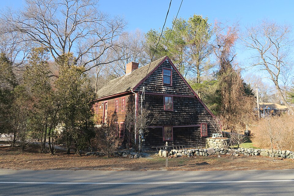
Listed on the National Register of Historic Places in
1979. A historic map-sheet match is not published yet. The record needs a coordinate-quality review before it can be joined to a sheet boundary.
From the record
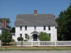
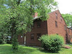
“The Chaplin-Clarke House is a historic First Period house at 109 Haverhill Street in Rowley, Massachusetts. Its oldest section built c. 1670 by Joseph Chaplin, it is the oldest house in Rowley.”
Wikipedia article Chaplin-Clarke House, CC BY-SA 4.0.
one of 350 National Register listings in Essex County · listed in 1979 · category: Building · one of 2 National Historic Landmarks in Essex County.
National Register reference number.79000343- the number the National Park Service assigned this property when it was listed, and the key its nomination file is catalogued under at the National Archives.
Fires near this property
58 since 2015
Regional context, not property-specific
evidence. The
federal wildfire occurrence database
lists 58 fires within 5 miles of Chaplin-Clarke House between
2015 and 2020, burning about 43 acres in total. 1 started naturally. 9 were recorded as arson.
Distance is straight-line from the map coordinates, so a fire counted
here may appear on a neighbouring settlement's page as well.
Reported cause
Fires
Debris and open burning
22
Arson/incendiarism
9
Equipment and vehicle use
8
Power generation/transmission/distribution
4
Recreation and ceremony
3
Railroad operations and maintenance
3
Missing data/not specified/undetermined
3
Smoking
3
Misuse of fire by a minor
2
Natural
1
The most recent of
them, most recent first, with the day each was reported and the service
that recorded it.
Regional context, not property-specific
evidence. Museums hold 3,055 specimens
collected within 10 miles of Chaplin-Clarke House between 1821 and
1975: 1,407 Plantae, 985 Animalia, 556 Fungi, 70 Chromista, 15 Unrecorded, 12 Bacteria, 10 Protozoa. 12 distinct Species records are shown.
Collected by A Brown, A. A. Eaton, A. A. Eaton; R. G. Leavitt and others. Each is a
physical object with a catalogue
number, and each entry opens the museum's record. This is what was
collected and kept, not a survey of what lives here - nothing can be
concluded from a species being absent.
Regional context, not property-specific
evidence. The federal mineral resources record lists
8 workings within 5 miles of Chaplin-Clarke House: 6 past producers, 2 producers.
2 still produce. What was taken out: Sand and Gravel, Construction, Lead, Silver. Distance is straight-line from the
map coordinates, so a quarry counted here may appear on a neighbouring
settlement's page as well.
Regional context, not property-specific
evidence. The National Weather Service names
Rowley, the town this property stands in, in 7 storm reports between 1999 and 2023: 5 thunderstorm wind, 2 hail.
No death or injury is recorded in these reports. Each account below is quoted exactly as the forecast office
filed it, from the NOAA Storm Events Database, and each date
opens the federal record of that event.
No historic map-sheet match is published
for this property yet. That does not mean no map exists. This record needs
a coordinate-quality review before it can be joined to a sheet boundary.
Browse the county's mapped places while that work is
pending.
From the nomination file
1,577 words on record
When this property was proposed for the
National Register, someone wrote the case for it: what the building is,
and why it matters. That document is a federal record in the public domain.
It is quoted below word for word, never summarised. The text was read off the scanned case file by machine, so the
occasional stray character is the recogniser's and the 1970s
typewriter's.
Description of the property
The Chaplin-Clarke House is located on Haverill Street a short distance southwest of Row- ley Center. Despite its proximity to the center, the setting is rural and landscaping is natural. The house, which faces south, is built into the side of a hill so that its western half is 1½ stories in height while its eastern half is 2½ stories. The facade of this five bay, center entrance house is sheathed in clapboards while the side elevations are shingled. The gabled lean-to roof is covered with cedar shingles and the central chimney is parged. Exterior decorative detail is minimal, consisting of simple cornerboards, door and window surrounds. On the east elevation there is a framed overhang on the second story and a hewn overhang in the attic.
The facade is asymmetrical with the entrance' placed slightly west of center. The two windows on the one story west side 'are full size, while those on the two story eastern side are smaller and are placed above a similar pair lighting the first story. is a second entrance to the ground floor in the eastern corner. The west elevation has one window in the attic and two at the first floor as well as a door and small square window in the lean-to. The east elevation has one window each in the attic and second story and three at the first floor. Fenestration on the low rear elevation is irregular. A second chimney rises from the northwest corner of the ell.
Interior details include one seven foot and two ten foot fireplaces, chamfered struc- tural members, and some original sheathing and hardware.
Statement of significance
/ARCHITECT Joseph Chaplin STATEMENT OF SIGNIFICANCE The Chaplin-Clarke house, which is the oldest in Rowley, is an unusual and well pre- served example of seventeenth century construction. It is believed that it stands on the site of a primitive structure erected by Hugh Chaplin in 1643. His son Joseph. erected a one room deep house c.1670 when he married.; The, lean-to was added c.1700 completing the form of the present house. Early in the eighteenth century the property was acquired by Richard Clarke who is buried a few rods west of the house. It had only one other owner before being ac- quired by the Society for the Preservation of New England Antiquities early in the twentieth century. Recently it has been returned to private ownership.
Long regarded as the oldest house in town, the Chaplin-Clarke house is the last vestige of Rowley's original settlement which, by 1650, had grown to include sixty families. An archeological investigation of the area could reveal significant information about early historic period contruction techniques and lifeways in Rowley. The data coula also provide comparative information about 17th century coastal adaptations.
Quoted from the National Register nomination
for reference 79000343, 10 pages, held by the National Archives in Record
Group 79. See the
catalogue record.
Listed places nearby
6 within 8 miles
Other National Register properties close
enough to walk or drive between, ordered by distance from this one. Both
positions come from the same geocoding pass that matched these properties
to their map sheets.
Listing record. National Park Service National Register of Historic Places, listed-properties dataset, current to 2026-05-22.
Map join. Address geocoded through the United States Census geocoder, then tested against the published boundary of every sheet in the USGS Historical Topographic Map Collection.
How this page is made. Listing fields come from federal records; map-sheet coverage is a labelled coordinate-to-boundary calculation, not a source-field claim.
Wildfire. Short, Karen C. 2022. Spatial wildfire occurrence data for the United States, 1992-2020 [FPA_FOD_20221014]. 6th Edition. Fort Collins, CO: Forest Service Research Data Archive. https://doi.org/10.2737/RDS-2013-0009.6 Collected with United States Government funding and usable without additional permissions or fees.
Specimens. Global Biodiversity Information Facility (GBIF), https://www.gbif.org/. Only records licensed CC0 or CC BY are used. Records licensed CC BY-NC are excluded because this site carries advertising. Images are checked individually and any whose licence is non-commercial, no-derivatives or unreadable is refused.
Mines and quarries. USGS Mineral Resources Data System (MRDS) https://mrdata.usgs.gov/mrds/ A work of the United States government, no copyright under 17 U.S.C. 105.
Storms. NOAA National Centers for Environmental Information, Storm Events Database https://www.ncei.noaa.gov/stormevents/ A work of the United States government, no copyright under 17 U.S.C. 105. Narratives are quoted verbatim from the National Weather Service report and are not edited or summarised.
 Block
Block