Listed on the National Register of Historic Places in
1979. A historic map-sheet match is not published yet. The record needs a coordinate-quality review before it can be joined to a sheet boundary.
From the record
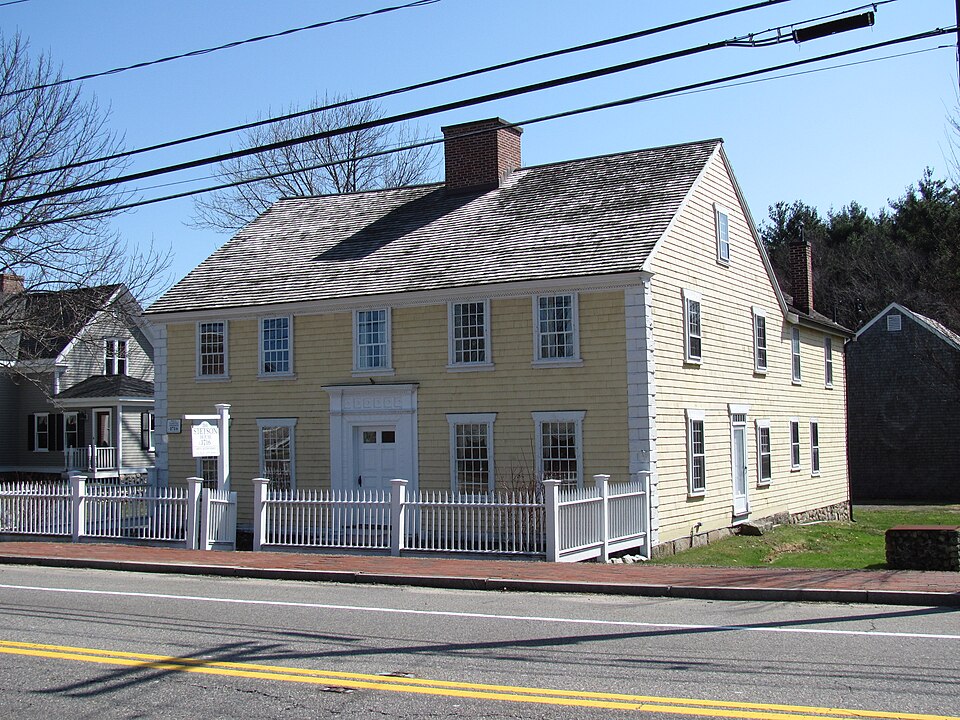
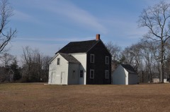
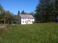
“The Stetson House is a historic house at Hanover Street in Hanover, Massachusetts. The frame house was built c. 1694 by Samuel "Drummer" Stetson and was occupied by the Stetson family until at least the 1860s.”
Wikipedia article Stetson House, CC BY-SA 4.0.
one of 93 National Register listings in Plymouth County · listed in 1979 · category: Building · one of 1 National Historic Landmarks in Plymouth County.
National Register reference number.79000366- the number the National Park Service assigned this property when it was listed, and the key its nomination file is catalogued under at the National Archives.
Probably no citizen of Hanover was more active or conspicious during the war than Joseph Cushing. He lived in a house which stood where now stands that of Horace S. Tower, and the latter uses the Cushing well for his water supply.
The Hanover artillery company's service was not all performed at home. From July 1 to Sept. 6, 1814, (68 days) under Lieut. Elisha Barrell, Jr., a detachment of it was on duty at Scituate Harbor and the whole company was for a month, September 19 to October 19, 1814. at Plymouth.
Regional context, not property-specific
evidence. The
federal wildfire occurrence database
lists 293 fires within 5 miles of Stetson House between
2015 and 2020, burning about 82 acres in total. 2 started naturally. 3 were recorded as arson.
Distance is straight-line from the map coordinates, so a fire counted
here may appear on a neighbouring settlement's page as well.
Reported cause
Fires
Debris and open burning
172
Missing data/not specified/undetermined
89
Misuse of fire by a minor
21
Smoking
6
Arson/incendiarism
3
Natural
2
The most recent of
them, most recent first, with the day each was reported and the service
that recorded it.
Regional context, not property-specific
evidence. Museums hold 1,053 specimens
collected within 10 miles of Stetson House between 1836 and
1975: 464 Plantae, 308 Animalia, 176 Fungi, 72 Unrecorded, 16 Chromista, 11 Protozoa, 6 Bacteria. 12 distinct Species records are shown.
Collected by A. A. Eaton, A. B. Seymour, A. C. Mathieson and others. Each is a
physical object with a catalogue
number, and each entry opens the museum's record. This is what was
collected and kept, not a survey of what lives here - nothing can be
concluded from a species being absent.
Regional context, not property-specific
evidence. The federal mineral resources record lists
3 workings within 5 miles of Stetson House: 3 past producers.
None of them still produces. What was taken out: Sand and Gravel, Construction. Distance is straight-line from the
map coordinates, so a quarry counted here may appear on a neighbouring
settlement's page as well.
Regional context, not property-specific
evidence. The National Weather Service names
Hanover, the town this property stands in, in 8 storm reports between 2001 and 2023: 3 thunderstorm wind, 2 hail, 2 lightning, 1 flood.
The reports record 1 injury. Each account below is quoted exactly as the forecast office
filed it, from the NOAA Storm Events Database, and each date
opens the federal record of that event.
A man in his 30s was struck by lightning while holding a personal electronic device at an auto repair shop. Lightning struck the ground nearby and jumped to the electronic device. Injuries were reported as not life threatening.
Several small streams went into flood, including the Taunton River at Bridgewater, the Jones River at Kingston, and the Indian Head River at Hanover. Several streets were closed throughout East Bridgewater, Bridgewater, and Whitman. In addition, collections at the Holmes Public Library in Halifax were damaged by floodwaters. Residents of John Dunn Drive in Rockland were evacuated from their homes. Forty homes in Brockton were evacuated after power and gas were shut off to the houses. Several roads were closed in Brockton due to flooding.
No historic map-sheet match is published
for this property yet. That does not mean no map exists. This record needs
a coordinate-quality review before it can be joined to a sheet boundary.
Browse the county's mapped places while that work is
pending.
From the nomination file
2,499 words on record
When this property was proposed for the
National Register, someone wrote the case for it: what the building is,
and why it matters. That document is a federal record in the public domain.
It is quoted below word for word, never summarised. The text was read off the scanned case file by machine, so the
occasional stray character is the recogniser's and the 1970s
typewriter's.
Description of the property
The Stetson House is a two and one-half story frame structure with a later ell, facing north, on a roughly two-acre site in Hanover Center. Although the present dwelling house dates primarily from c. 1760, it incorporates portions of an earlier (c. 1700) house. Structural evidence suggests that the barn also may date from c. 1700. The street facade of the Stetson House displays granite Ioundation tacing, wood water table, and symmetrical placement of five bays with a center entrance. Ihe sash are 12/12 on the first story and 12/8 on the second. BZTE The elaborate entrance frontispiece with fluted Doric pilasters, rusticated paneling, quoins, and dentilated cornice probably dates from c.
1790, as does teeloey motef undar te as pamo od an they teentmicee tury shestora, pninted mid-nineteenth-century ell extends from the southwest portion of the house. The earliest interior area is the southeast room where there is a fireplace core with exposed beams. The summer beam there is champtered with lambs' tongue stops. In the northwest parlor the decorative wood trim has late eighteenth-century mouldings and a "rustification" motif which is unusual but corresponds to the same detailing on the entrance frontispiece. The cupboard door beside the fire- place has raised field paneling. Above this parlor, the northwest chamber is similar. In both of these rooms the trim represents an interesting provincial interpretation of transitional Georgian-Federal woodwork.
Trim work having a more typical vernacular Federal design exists in the mortheast parlor. The northeast and southeast chambers underwent "restoration" sometime between 1916 and 1928. The owner, Dr. Lloyd Vernon Briggs, left no records to justify his choices. These two chambers have exposed traming. Ihe wall surtace in the northeast chamber is simply the interior side of the exterior wall sheathing.
The Stetson House, built c. 1700, retains integrity of location, design, materials and workmanship and is one of the earliest extant buildings in Hanover Center. It is also associated with one of Hanover's oldest families and remained in their ownership for nearly iwo hundred years. During its earlier years it played a key role in the life of the community serving as a tavern and a meetinghouse. It stands on a two-acre plot which is part of a far more extensive parcel of land originally acquired in 1634 for the Plymouth Colony by the first Stetson in the area, Robert Stetson. The area was then known as Scituate, and Stetson obtained a section encompassing parts of Scituate and present-day Hingham and Abington from the Namasakeesett Indians.
In 1634 the Plymouth Colony Court granted Stetson a "considerable tract of land" which included shore along the Nhe towm or, sand part of Herring Brook. By 1642 the area was incorporated as Stetson erected a saw mill on Herring Brook in 1656, probably the first in that part of the colony. "Cornet" Robert Stetson, so named because he was a Cornet of the first light horse corps in the Colony, was said to have considerable wealth. He served as a Deputy to the Colony Court, a Colony Cormissioner, and a member of the Council of War. One on his sons, Captain Benjamin Stetson, was very likely the builder of the house. As early as 1690, Captain Stetson was engaged in shipbuilding on the North River. He left the property, with an unspecified acerage, to his son Samuel in 1715.
Samuel, known in the records as "Drummer" Stetson, evidently continued the family tradition of nickname by CER military association.
Quoted from the National Register nomination
for reference 79000366, 17 pages, held by the National Archives in Record
Group 79. See the
catalogue record.
Listed places nearby
6 within 8 miles
Other National Register properties close
enough to walk or drive between, ordered by distance from this one. Both
positions come from the same geocoding pass that matched these properties
to their map sheets.
Listing record. National Park Service National Register of Historic Places, listed-properties dataset, current to 2026-05-22.
Map join. Address geocoded through the United States Census geocoder, then tested against the published boundary of every sheet in the USGS Historical Topographic Map Collection.
How this page is made. Listing fields come from federal records; map-sheet coverage is a labelled coordinate-to-boundary calculation, not a source-field claim.
Wildfire. Short, Karen C. 2022. Spatial wildfire occurrence data for the United States, 1992-2020 [FPA_FOD_20221014]. 6th Edition. Fort Collins, CO: Forest Service Research Data Archive. https://doi.org/10.2737/RDS-2013-0009.6 Collected with United States Government funding and usable without additional permissions or fees.
Specimens. Global Biodiversity Information Facility (GBIF), https://www.gbif.org/. Only records licensed CC0 or CC BY are used. Records licensed CC BY-NC are excluded because this site carries advertising. Images are checked individually and any whose licence is non-commercial, no-derivatives or unreadable is refused.
Mines and quarries. USGS Mineral Resources Data System (MRDS) https://mrdata.usgs.gov/mrds/ A work of the United States government, no copyright under 17 U.S.C. 105.
Storms. NOAA National Centers for Environmental Information, Storm Events Database https://www.ncei.noaa.gov/stormevents/ A work of the United States government, no copyright under 17 U.S.C. 105. Narratives are quoted verbatim from the National Weather Service report and are not edited or summarised.
 Block
Block