BlockBefore
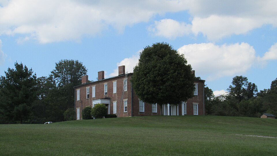
Photograph of Higby House
Photograph by Aesopposea, CC BY-SA 3.0. Via Wikimedia Commons.

Higby House

Listed on the National Register of Historic Places in 1979. A historic map-sheet match is not published yet. The record needs a coordinate-quality review before it can be joined to a sheet boundary.

From the record

one of 22 National Register listings in Ross County · listed in 1979 · category: Building.

Sources: the case file at the National Archives · the National Register database, National Park Service

The listing

  • What is counted as historic. The nomination lists 1 building as contributing to the listing.
  • Address. S of Chillicothe on Three Locks Rd, Chillicothe, 45601
  • When was it listed? 1979-11-29
  • Category. building
  • Township. Franklin township
  • Architectural style. Greek Revival architecture
  • National Register reference number. 79001933 - the number the National Park Service assigned this property when it was listed, and the key its nomination file is catalogued under at the National Archives.

Fires near this property

48 since 2005

Regional context, not property-specific evidence. The federal wildfire occurrence database lists 48 fires within 5 miles of Higby House between 2005 and 2020, burning about 172 acres in total. None started naturally. 2 were recorded as arson. Distance is straight-line from the map coordinates, so a fire counted here may appear on a neighbouring settlement's page as well.

Reported cause Fires
Debris and open burning24
Missing data/not specified/undetermined16
Equipment and vehicle use3
Arson/incendiarism2
Power generation/transmission/distribution1
Recreation and ceremony1
Smoking1

The most recent of them, most recent first, with the day each was reported and the service that recorded it.

DateCause SizeReported by Name on the report
7 September 2007Missing data/not specified/undetermined6.0 acresOhio Department of Natural Resourcesnot named
7 September 2007Debris and open burning2.0 acresOhio Department of Natural Resourcesnot named
7 September 2007Equipment and vehicle use5.0 acresOhio Department of Natural Resourcesnot named
6 September 2007Missing data/not specified/undetermined4.0 acresOhio Department of Natural Resourcesnot named
6 September 2007Missing data/not specified/undetermined2.0 acresOhio Department of Natural Resourcesnot named
4 September 2007Missing data/not specified/undetermined1.5 acresOhio Department of Natural Resourcesnot named
3 September 2007Missing data/not specified/undetermined2.0 acresOhio Department of Natural Resourcesnot named
22 September 2010Debris and open burningunder an acreOhio Department of Natural Resourcesnot named

Every fire recorded in Ross County

Specimens collected near this property

12 of 781 shown

Regional context, not property-specific evidence. Museums hold 781 specimens collected within 10 miles of Higby House between 1923 and 1975: 706 Animalia, 50 Fungi, 20 Plantae, 5 Protozoa. 12 distinct Species records are shown. Collected by A. C. Lincoln, A. Cronquist, A. Spreitzer and others. Each is a physical object with a catalogue number, and each entry opens the museum's record. This is what was collected and kept, not a survey of what lives here - nothing can be concluded from a species being absent.

Image SpeciesYear Collected by Where, as recorded
A photograph of the species Aceria ulmicola, not of this specimenAceria ulmicola Nalepa, 19091923Miller, A. E. (August E.)Richmond Dale, Ross Co., OH, U.S.A.
A photograph of the species Sceloporus undulatus, not of this specimenSceloporus undulatus (Bosc & Daudin, 1801)1926ROBT ENDERS3 MI N ALMA
A photograph of the species Ammocrypta pellucida, not of this specimenAmmocrypta pellucida (Putnam, 1863)1929Trautman, M. B. (Milton Bernard) & Foster, R. (Robert)Salt Creek, near US 50, east of Londonderry OH, Liberty Township
A photograph of the species Carpiodes cyprinus, not of this specimenCarpiodes cyprinus hinei Trautman, 19561929MB Trautman & ass't.Paint Creek, trib of Scioto River near mouth, Springfield Twp
A photograph of the species Etheostoma blennioides, not of this specimenEtheostoma blennioides Rafinesque, 18191929MB Trautman & ass't.Paint Creek, trib of Scioto River near mouth, Springfield Twp
A photograph of the species Etheostoma nigrum, not of this specimenEtheostoma nigrum Rafinesque, 18201929MB Trautman & ass't.Paint Creek, trib of Scioto River near mouth, Springfield Twp
A photograph of the species Etheostoma variatum, not of this specimenEtheostoma variatum Kirtland, 18401929MB Trautman & ass't.Paint Creek, trib of Scioto River near mouth, Springfield Twp
A photograph of the species Etheostoma zonale, not of this specimenEtheostoma zonale (Cope, 1868)1929MB Trautman & ass't.Paint Creek, trib of Scioto River near mouth, Springfield Twp
A photograph of the species Hybopsis Agassiz, not of this specimenHybopsis Agassiz, 18541929Trautman, M. B. (Milton Bernard) & Foster, R. (Robert)Scioto River, within Jefferson township, near Richmond Dale, Jefferson township
A photograph of the species Hypentelium nigricans, not of this specimenHypentelium nigricans (Lesueur, 1817)1929Trautman, M. B. (Milton Bernard) & Foster, R. (Robert)Scioto River, within Jefferson township, near Richmond Dale, Jefferson township
A photograph of the species Micropterus dolomieu, not of this specimenMicropterus dolomieu dolomieu Lacepède, 18021929Trautman, M. B. (Milton Bernard) & Foster, R. (Robert)Scioto River, within Jefferson township, near Richmond Dale, Jefferson township
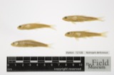
A photograph of the species Notropis deliciosus, not of this specimenNotropis deliciosus (Girard, 1856)1929Trautman, M. B. (Milton Bernard) & Foster, R. (Robert)Scioto River, within Jefferson township, near Richmond Dale, Jefferson township

All 781 specimens within 10 miles, at the Global Biodiversity Information Facility.

Mines and quarries near this property

8 within 5 miles

Regional context, not property-specific evidence. The federal mineral resources record lists 8 workings within 5 miles of Higby House: 5 past producers, 2 producers, 1 plant. 3 still produce. What was taken out: Sand and Gravel, Construction, Stone, Crushed/Broken. Distance is straight-line from the map coordinates, so a quarry counted here may appear on a neighbouring settlement's page as well.

Where SiteCommodity StatusRecorded
Southern Silica Inc PitStone, Crushed/BrokenProducer
Southern Silica Sandstone PitStone, Crushed/BrokenPast ProducerSedimentary
Miami Gravel PitSand and Gravel, ConstructionPast ProducerSedimentary
Miami Gravel PitSand and Gravel, ConstructionProducer
Morrison PitSand and Gravel, ConstructionPast ProducerSedimentary
Morrison PitSand and Gravel, ConstructionPast Producer
Parry CompanySand and Gravel, ConstructionPlant
Parry Silica Sand and Gravel PlantSand and Gravel, ConstructionPast ProducerSedimentary

Every working recorded in Ross County

Storms near this property

60 of 92 shown

Regional context, not property-specific evidence. The National Weather Service names Chillicothe, the town this property stands in, in 92 storm reports between 1995 and 2025: 56 thunderstorm wind, 24 hail, 6 flood, 3 lightning. The reports record 1 death and 6 injuries. Each account below is quoted exactly as the forecast office filed it, from the NOAA Storm Events Database, and each date opens the federal record of that event.

WhenEvent Place namedHarm What the report says
June 2005LightningChillicothe1 killed, 5 hurtAn inmate in the yard at the Chillicothe Correctional Institute was struck and killed by lightning. Five others were injured by the lightning strike.
September 1999LightningChillicothe1 hurtA man was struck by lightning and suffered injury.
May 2000LightningChillicothe$30,000A lightning strike caused a fire in the attic of a house leading to extensive damage.
February 2000Flash FloodChillicothe$25,000North Fork Creek flooded west of Chillicothe causing evacuation of a camp ground.
June 2022Thunderstorm WindChillicothe$20,000Numerous trees were downed and trees were snapped in the Chillicothe area.
June 2012Thunderstorm WindChillicothe$15,000A metal roof was removed from a building on Race Street due to thunderstorm winds.
April 2005HailChillicothe$15,000no account filed
June 2011Thunderstorm WindChillicothe$12,000Trees and utility poles were reported down due to damaging thunderstorm winds.
July 2012Thunderstorm WindChillicothe$10,000Numerous trees were reported down along several roadways in the county.
April 2011Thunderstorm WindChillicothe$10,000Damage occurred to a building due to thunderstorm winds.
July 2003Flash FloodChillicothe$10,000Several homes were flooded and one road was washed out.
July 2002Flash FloodChillicothe$10,000Problems with high water occurred across the county. A roof of a gas station on the west side of Chillicothe collapsed under the weight of the heavy rain.
September 2000Thunderstorm WindChillicothe$10,000Numerous trees downed.
August 2000Thunderstorm WindChillicothe$10,000Strong winds blew trailers over at the county fair.
July 1998Thunderstorm WindChillicothe$10,000Numerous trees downed.
July 1997Thunderstorm WindChillicothe$10,000Several trees knocked down across the county.
April 2002HailChillicothe$10,000no account filed
February 2011Thunderstorm WindChillicothe$7,000A small metal shed was destroyed, trees were down, and power lines were down due to damaging thunderstorm winds.
June 1995HailChillicothe$6,000Crop damage was reported due to wind blown hail.
July 2022Thunderstorm WindChillicothe$5,000A large tree fell onto a house and knocked down some power lines.
June 2019Thunderstorm WindChillicothe$5,000Numerous trees were knocked down throughout the county, including in and around Chillicothe.
June 2011Thunderstorm WindChillicothe$5,000Trees and power lines were reported down due to damaging thunderstorm winds.
June 2007Thunderstorm WindChillicothe$5,000Several trees and power poles were knocked down in the Great Seal State Forest and along Marietta Road.
June 2001Thunderstorm WindChillicothe$5,000Thunderstorms produced strong winds which moved 500 pound bleachers and tore off dugout roofs at a ball field.
April 2000Thunderstorm WindChillicothe$5,000Numerous trees downed.
August 1999Thunderstorm WindChillicothe$5,000Several large trees downed.
July 1997Thunderstorm WindChillicothe$5,000Trees and power lines downed.
August 2007HailChillicothe$5,000no account filed
April 2002HailChillicothe$5,000no account filed
May 1996Thunderstorm WindChillicothe$5,000no account filed
May 2024Thunderstorm WindChillicothe$4,000A few trees were downed on the southeast side of Chillicothe.
July 2023Thunderstorm WindChillicothe$4,000A few trees were downed in Chillicothe.
June 2008Thunderstorm WindChillicothe$4,000Large tree limbs were downed across several roads.
April 2006Thunderstorm WindChillicothe$4,000Several tree limbs were downed.
May 2024Thunderstorm WindChillicothe$3,000A few trees were downed on Church Street and Carlisle Place.
May 2022Thunderstorm WindChillicothe$3,000Several trees were downed along Eastern Avenue near U.S. 23.
August 2020Thunderstorm WindChillicothe$3,000Trees were reported knocked down near the intersection of Liberty Hill Road and OH-772.
August 2020Thunderstorm WindChillicothe$3,000Trees were reported knocked down.
May 2009Thunderstorm WindChillicothe$3,000Trees were downed in town.
June 2005Thunderstorm WindChillicothe$3,000Trees were knocked down.
May 2004Thunderstorm WindChillicothe$3,000A few trees were downed.
August 2003Thunderstorm WindChillicothe$3,000Trees and powerlines were downed.
August 2002Thunderstorm WindChillicothe$3,000Trees were downed on the north and east sides of town.
April 2001Thunderstorm WindChillicothe$3,000A thunderstorm produced strong winds which knocked down a few trees.
June 2001Thunderstorm WindChillicothe$3,000A few trees downed
May 2001Thunderstorm WindChillicothe$3,000Trees were knocked down by thunderstorm winds.
July 1999Thunderstorm WindChillicothe$3,000Numerous trees knocked down.
September 1999Thunderstorm WindChillicothe$3,000Trees were knocked down across Rocky Road.
July 1998Thunderstorm WindChillicothe$3,000Trees downed.
June 1998Thunderstorm WindChillicothe$3,000Several trees downed.
July 1997Thunderstorm WindChillicothe$3,000Several trees downed.
April 2002HailChillicothe$3,000no account filed
November 2020Thunderstorm WindChillicothe$2,000A few trees were downed.
August 2020Thunderstorm WindChillicothe$2,000Trees were reported knocked down.
December 2013Thunderstorm WindChillicothe$2,000A few trees were down across the county due to thunderstorm winds.
June 2011Thunderstorm WindChillicothe$2,000A few trees were reported down due to damaging thunderstorm winds.
October 2010Thunderstorm WindChillicothe$2,000Trees and large tree limbs were reported down due to damaging thunderstorm winds.
June 2003Thunderstorm WindChillicothe$2,000Large limbs and branches were knocked down.
October 2006HailChillicothe$2,000no account filed
May 2022Thunderstorm WindChillicothe$1,000A large tree was downed along East Main Street. Several large branches were also downed in the area.

Every storm recorded in Ross County

Map coverage status

No historic map-sheet match is published for this property yet. That does not mean no map exists. This record needs a coordinate-quality review before it can be joined to a sheet boundary. Browse the county's mapped places while that work is pending.

From the nomination file

1,565 words on record

When this property was proposed for the National Register, someone wrote the case for it: what the building is, and why it matters. That document is a federal record in the public domain. It is quoted below word for word, never summarised. The text was read off the scanned case file by machine, so the occasional stray character is the recogniser's and the 1970s typewriter's.

Description of the property

columns supporting a three part entablature and sheltering a six panel door with supported by Doric columns that shelters another six panel door with transom. A combination frame and brick addition was made at the rear in the center of the L. It has details similar to the remainder of the house. the house and a small brick out building with stepped brick dentils at the cornice. a large frame barn in poor condition lies to the west of the house. The nominated property includes the main house and related outbuildings along with a small portion of the hillside setting of the complex. Doric ruins Condition deteriorated unexposed There is a one-story portico on the front entrance consisting of paired 7. Description been removed. and one end wall chimney.

Check one construction and the foundation is ashlar stone.There are three sidewall chimneys sidelights and transom.On the side of the house is another entrance with a portico The Dresbach House is a two-story Greek Revival common bond brick residence.It is L-shaped with five front bays and six on the side.The roof is gabled and of metal A small frame shed with standing seam metal roof is a short distance to the rear of and slightly projecting eaves. A few wooden shutters remain but the majority have The box gutters have been removed revealing stepped brick dentils under the plain The windows are 6/6 double hung sash.The sills and lintels are plain stone lug. -good 8.

Statement of significance

(in one paragraph) house popular in Ross County during the middle the nineteenth century- This local manifestation of the style was portrayed by Talbot Hamlin as characterized The Higby House was described in the 1880 county history as "a spacious brick mansion facade and side elevation help to emphasize the brick dentil work at the cornice and Situated on the side of a low hill overlooking the Scioto River, Ohio and Erie Canal, Scioto Valley Railroad, and Three Locks Road, the house was especially well sited to take advantage of the commerce moving through the valley. It was built for Sylvester The setting of the property is noteworthy with an exceptional view of the Scioto Valley the crest the elevation on which the property is located.

1857 1600-1699 1700-1799 economics 1500-1599 1400-1499 communications commerce engineering industry theater humanitarian transportation Builder/Architect conservation exploration/settlement literature invention music Period and business. science Specific dates politics/government law 1900- by brick houses with austere detailing, low roof-lines, and small classical porticos.

- other (specify) N.Higby who worked as a farmer and served as the storekeeper, station agent, and post- built in 1857,[and elegantly furnished."The austerity of the wall surfaces of the stretching out to the south of the property.The hillside setting of the property .agriculture -art - archeology-prehistoric - community planning - religion The Higby House is significant as an excellent example of the Greek Revival style of the Doric columned porticos. All combine to make the house a particularly noteworthy example of the special Greek Revival styling found in Ross County. With the exception of the cornice, the house remains much as it was shown in the 1875 county atlas. landscape architecture contributes to its visual significance and the nominated area includes author, 1875.

Hamlin, Talbot. Greek Revival Architecture in America, London:Oxford University Press, 1944.

Read the complete 1,565-word case file.

The whole case file for this property - 1,565 words, 13 pages, reproduced complete.

Quoted from the National Register nomination for reference 79001933, 13 pages, held by the National Archives in Record Group 79. See the catalogue record.

Listed places nearby

1 within 8 miles

Other National Register properties close enough to walk or drive between, ordered by distance from this one. Both positions come from the same geocoding pass that matched these properties to their map sheets.

Photograph PropertyDistance Listed
Highbank Farm5.3 miles1980

Sources for this property

National Archives recordThe nomination case file for reference 79001933 in Record Group 79.
Ross CountyAll 22 listed properties in this county.

Provenance

  • Listing record. National Park Service National Register of Historic Places, listed-properties dataset, current to 2026-05-22.
  • Map join. Address geocoded through the United States Census geocoder, then tested against the published boundary of every sheet in the USGS Historical Topographic Map Collection.
  • How this page is made. Listing fields come from federal records; map-sheet coverage is a labelled coordinate-to-boundary calculation, not a source-field claim.
  • Wildfire. Short, Karen C. 2022. Spatial wildfire occurrence data for the United States, 1992-2020 [FPA_FOD_20221014]. 6th Edition. Fort Collins, CO: Forest Service Research Data Archive. https://doi.org/10.2737/RDS-2013-0009.6 Collected with United States Government funding and usable without additional permissions or fees.
  • Specimens. Global Biodiversity Information Facility (GBIF), https://www.gbif.org/. Only records licensed CC0 or CC BY are used. Records licensed CC BY-NC are excluded because this site carries advertising. Images are checked individually and any whose licence is non-commercial, no-derivatives or unreadable is refused.
  • Mines and quarries. USGS Mineral Resources Data System (MRDS) https://mrdata.usgs.gov/mrds/ A work of the United States government, no copyright under 17 U.S.C. 105.
  • Storms. NOAA National Centers for Environmental Information, Storm Events Database https://www.ncei.noaa.gov/stormevents/ A work of the United States government, no copyright under 17 U.S.C. 105. Narratives are quoted verbatim from the National Weather Service report and are not edited or summarised.