Listed on the National Register of Historic Places in
1980. A historic map-sheet match is not published yet. The record needs a coordinate-quality review before it can be joined to a sheet boundary.
From the record
one of 11 National Register listings in Ashland County · listed in 1980 · category: Building.
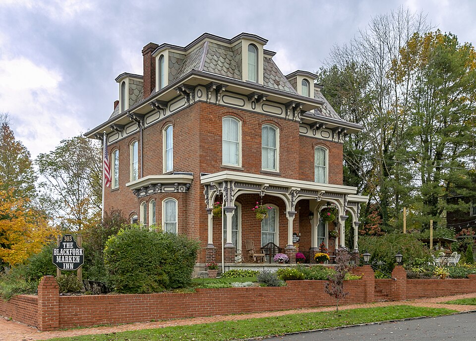
Architectural style. Second Empire architecture in the United States and Canada
National Register reference number.80002935- the number the National Park Service assigned this property when it was listed, and the key its nomination file is catalogued under at the National Archives.
Regional context, not property-specific
evidence. The
federal wildfire occurrence database
lists 14 fires within 5 miles of Black, Philip J., House between
2005 and 2020, burning about 22 acres in total. None started naturally. 1 was recorded as arson.
Distance is straight-line from the map coordinates, so a fire counted
here may appear on a neighbouring settlement's page as well.
Reported cause
Fires
Debris and open burning
4
Smoking
4
Missing data/not specified/undetermined
3
Power generation/transmission/distribution
1
Recreation and ceremony
1
Arson/incendiarism
1
The most recent of
them, most recent first, with the day each was reported and the service
that recorded it.
Regional context, not property-specific
evidence. Museums hold 551 specimens
collected within 10 miles of Black, Philip J., House between 1896 and
1975: 516 Animalia, 30 Plantae, 5 Fungi. 12 distinct Species records are shown.
Collected by A C ALLEN, A.E. Daugherty, Auten, M. and others. Each is a
physical object with a catalogue
number, and each entry opens the museum's record. This is what was
collected and kept, not a survey of what lives here - nothing can be
concluded from a species being absent.
Regional context, not property-specific
evidence. The federal mineral resources record lists
2 workings within 5 miles of Black, Philip J., House: 1 past producer, 1 producer.
1 still produces. What was taken out: Sand and Gravel, Construction. Distance is straight-line from the
map coordinates, so a quarry counted here may appear on a neighbouring
settlement's page as well.
Regional context, not property-specific
evidence. The National Weather Service names
Loudonville, the town this property stands in, in 36 storm reports between 1995 and 2025: 18 thunderstorm wind, 12 hail, 4 flash flood, 1 lightning.
No death or injury is recorded in these reports. Each account below is quoted exactly as the forecast office
filed it, from the NOAA Storm Events Database, and each date
opens the federal record of that event.
Severe thunderstorm winds downed trees, destroyed one garage and blew the roof off a barn. Another barn was blown down, killing some of the livestock inside. Crops were damaged.
Moderate rainfall fell over the Mohican Valley on Sunday May 9th. Rainfall amounts between 2 to 3 inches was reported between 6 am and 6 pm. The Black Fork reported flooding from well upstream in Richland County and again down in Loudonville where it meets the Mohican River. The Black Fork USGS gage at Loudonville exceeded flood stage on Sunday afternoon and reached moderate flood stage on the morning of the 10th, cresting at 11.3 feet. Flood waters inundated recreational campgrounds and liveries along the river. Due to the early season timing, there was limited population along the river, however damage was reported to numerous campers and some permanent structures.
Thunderstorm downburst winds estimated at 65 to 75 mph knocked down around two dozen trees in Mohican State Park. A distinct damage path approximately one quarter mile in length and 50 to 100 feet wide was observed. Most of the downed trees were 12 to 18 inches in diameter and were snapped near the ground.
Thunderstorms dumped two to three inches of rain on southern Ashland County in about an hour. The Mohican River went out its banks just west of Loudonville in Mohican State Park. A campground in the park had to be partially evacuated.
No historic map-sheet match is published
for this property yet. That does not mean no map exists. This record needs
a coordinate-quality review before it can be joined to a sheet boundary.
Browse the county's mapped places while that work is
pending.
From the nomination file
4,314 words on record
When this property was proposed for the
National Register, someone wrote the case for it: what the building is,
and why it matters. That document is a federal record in the public domain.
It is quoted below word for word, never summarised. The text was read off the scanned case file by machine, so the
occasional stray character is the recogniser's and the 1970s
typewriter's.
Description of the property
The house is four bays across and three bays deep, with the south two bays projecting out rectangular, featuring cut stone sills and segmental arches ornamented by corbelled brick- A robust wood cornice wraps around the entire building and features an unusual windows, two facing each direction. A large ornate porch spans the entire front, stepping at the northern half of the porch, but will be removed during the restoration now in been replaced by asphalt shingles, which are to be replaced in the near future with a slate-like material. A small one story enclosed wooden porch at the rear has recently The brick walls of this building have never been sandblasted or repointed.
The interior is remarkable for the absence of a central hallway, with the only Woodwork throughout the house is generally simple and massive, reflecting the house's level in the rear, due to a sloping terrain and has a brick floor, suggesting its possible This house is located near the northern edge of Loudonville, a community of about wall is in front as is a brick walkway, which has recently been restored. ruins unexposed deteriorated spacious parlors and a kitchen are located on the first floor and are interconnected by Xoriginal site back on the northern half to follow the outline of the building.Single carved wood This house is a two story brick structure which rests on a cut sandstone foundation.
separate the brackets.Above is a bell-cast mansard roof punctuated by a series of dormer Check one a series of broad archways.Of special note is the projecting bay window in the southeast Alterations to the exterior consist of a new concrete porch floor in front along Condition parlor which is framed by a magnificent ogee arch opening trimmed in ornate woodwork.
(in one paragraph) The Philip J. Black House is a rare and well-preserved example of Second Empire set it apart from other local buildings dating from the same period. Of secondary im- portance is the association of this building with its original owner, who was a leading After selling his business, Black entered the produce business where he became very the property for use as a hotel and restuarant. 1600-1699 1500-1599 1700-1799 1400-1499 communications economics Period conservation Builder/Architect humanitarian engineering unknown science invention law education industry 8. Significance The present owners acquired the property recently and are engaged in renovating business to J.F.Redd and presumably would have had some cash to build this house.
1900- was built about 1865,which is about the time that Black sold his grocery and baking military literature - politics/government landscape architecture _ religion example of the Second Empire style. The size, scale and craftsmanship of this building Philip J. Black acquired this land in 1860 from Nathaniel Haskell, a local banker at the age of 62,the house passed to his eldest daughter Josephine.It remained in the family until the death of his youngest daughter Minnie in 1944. successful.He was a Republican in politics and served as councilman and mayorof the who owned much 1and in and around the village.Family records indicate that the house local businessman and who served as mayorof Loudonville.
Quoted from the National Register nomination
for reference 80002935, 34 pages, held by the National Archives in Record
Group 79. See the
catalogue record.
Listed places nearby
3 within 8 miles
Other National Register properties close
enough to walk or drive between, ordered by distance from this one. Both
positions come from the same geocoding pass that matched these properties
to their map sheets.
Listing record. National Park Service National Register of Historic Places, listed-properties dataset, current to 2026-05-22.
Map join. Address geocoded through the United States Census geocoder, then tested against the published boundary of every sheet in the USGS Historical Topographic Map Collection.
How this page is made. Listing fields come from federal records; map-sheet coverage is a labelled coordinate-to-boundary calculation, not a source-field claim.
Wildfire. Short, Karen C. 2022. Spatial wildfire occurrence data for the United States, 1992-2020 [FPA_FOD_20221014]. 6th Edition. Fort Collins, CO: Forest Service Research Data Archive. https://doi.org/10.2737/RDS-2013-0009.6 Collected with United States Government funding and usable without additional permissions or fees.
Specimens. Global Biodiversity Information Facility (GBIF), https://www.gbif.org/. Only records licensed CC0 or CC BY are used. Records licensed CC BY-NC are excluded because this site carries advertising. Images are checked individually and any whose licence is non-commercial, no-derivatives or unreadable is refused.
Mines and quarries. USGS Mineral Resources Data System (MRDS) https://mrdata.usgs.gov/mrds/ A work of the United States government, no copyright under 17 U.S.C. 105.
Storms. NOAA National Centers for Environmental Information, Storm Events Database https://www.ncei.noaa.gov/stormevents/ A work of the United States government, no copyright under 17 U.S.C. 105. Narratives are quoted verbatim from the National Weather Service report and are not edited or summarised.
 Block
Block