Listed on the National Register of Historic Places in
1980. A historic map-sheet match is not published yet. The record needs a coordinate-quality review before it can be joined to a sheet boundary.
From the record
one of 7 National Register listings in Gallia County · listed in 1980 · category: Building.
National Register reference number.80003028- the number the National Park Service assigned this property when it was listed, and the key its nomination file is catalogued under at the National Archives.
Fires near this property
44 since 2006
Regional context, not property-specific
evidence. The
federal wildfire occurrence database
lists 44 fires within 5 miles of Davis Mill between
2006 and 2020, burning about 176 acres in total. None started naturally. 2 were recorded as arson.
Distance is straight-line from the map coordinates, so a fire counted
here may appear on a neighbouring settlement's page as well.
Reported cause
Fires
Debris and open burning
30
Missing data/not specified/undetermined
11
Arson/incendiarism
2
Equipment and vehicle use
1
The most recent of
them, most recent first, with the day each was reported and the service
that recorded it.
Regional context, not property-specific
evidence. Museums hold 149 specimens
collected within 10 miles of Davis Mill between 1900 and
1974: 115 Animalia, 19 Plantae, 12 Fungi, 2 Unrecorded, 1 Chromista. 12 distinct Species records are shown.
Collected by A. M. Evans, Babcocks D. O., Bartley, F. and others. Each is a
physical object with a catalogue
number, and each entry opens the museum's record. This is what was
collected and kept, not a survey of what lives here - nothing can be
concluded from a species being absent.
Regional context, not property-specific
evidence. The federal mineral resources record lists
1 working within 5 miles of Davis Mill: 1 producer.
All of them still produce. What was taken out: Stone, Crushed/Broken, Bituminous. Distance is straight-line from the
map coordinates, so a quarry counted here may appear on a neighbouring
settlement's page as well.
Regional context, not property-specific
evidence. The National Weather Service names
Patriot, the town this property stands in, in 16 storm reports between 1998 and 2022: 9 hail, 3 thunderstorm wind, 2 flash flood, 1 tornado.
No death or injury is recorded in these reports. Each account below is quoted exactly as the forecast office
filed it, from the NOAA Storm Events Database, and each date
opens the federal record of that event.
The tornado touched down near Burnette Road, then moved east across Hannan Trace Road, before dissipating east of Rocky Fork Road. In the vicinity of Hannan Trace Road, the tornado width was 150 yards and destroyed 3 barns. Wooden pieces of the barn, from 1 to 5 feet in length, became projectiles. The wood was scattered about the area, with some pieces wedged into the ground. The storm was rated as an F2 in this area. Elsewhere along its path, the tornado was weaker. Two homes received minor damage. Farm equipment and one truck were also damaged.
No historic map-sheet match is published
for this property yet. That does not mean no map exists. This record needs
a coordinate-quality review before it can be joined to a sheet boundary.
Browse the county's mapped places while that work is
pending.
From the nomination file
1,373 words on record
When this property was proposed for the
National Register, someone wrote the case for it: what the building is,
and why it matters. That document is a federal record in the public domain.
It is quoted below word for word, never summarised. The text was read off the scanned case file by machine, so the
occasional stray character is the recogniser's and the 1970s
typewriter's.
Description of the property
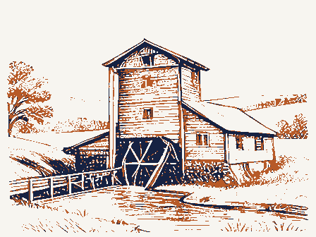
from about 1885 shows the building with both additions #5).No evidence has 1960's and used to build a house next to the mill; the addition was small and the The interior has hand-hewn timbers and much of the Tate 19th century machinery is The shed addition now serves as a small gift shop #4).The present owners plan one-story shed addition at the #2).The foundation is #3); X_altered siding (frame underneath) and a large, frame-sided dormer (photo #1). The building to retain and restore the machinery and, if feasible, remove the metal siding and The mill islocated on a rural road on the shores of Raccoon Creek.
Statement of significance
(in one paragraph) Areas of Significance-Check and justify below more than 100 miles from the Hocking Hills south through Vinton and Gallia Counties to the Ohio River.Cora Mill servedas a small commercial and grain processing center for mills once-located along Raccoon Creek have been demolished with the exception of Cora. Cora Mill is significant as the only remaining mill located on Raccoon Creek,which runs only because of the available water power but also because of the.high quality buhrstones and the wheel and the mill never again.operated.. of the numerous mills 1ocated along Raccoon Creek.There were over a dozen in Gallia _archeology-prehistoric community planning - landscape architecture _ religion Specific dates C.
1845-1937 surrounding farmers,many of whom had migrated to the area from Wales.It was only one County alone.The first mill to be built was Woods Mill, erected in 1803 in Gallia 9.
Quoted from the National Register nomination
for reference 80003028, 18 pages, held by the National Archives in Record
Group 79. See the
catalogue record.
Listed places nearby
1 within 8 miles
Other National Register properties close
enough to walk or drive between, ordered by distance from this one. Both
positions come from the same geocoding pass that matched these properties
to their map sheets.
Listing record. National Park Service National Register of Historic Places, listed-properties dataset, current to 2026-05-22.
Map join. Address geocoded through the United States Census geocoder, then tested against the published boundary of every sheet in the USGS Historical Topographic Map Collection.
How this page is made. Listing fields come from federal records; map-sheet coverage is a labelled coordinate-to-boundary calculation, not a source-field claim.
Wildfire. Short, Karen C. 2022. Spatial wildfire occurrence data for the United States, 1992-2020 [FPA_FOD_20221014]. 6th Edition. Fort Collins, CO: Forest Service Research Data Archive. https://doi.org/10.2737/RDS-2013-0009.6 Collected with United States Government funding and usable without additional permissions or fees.
Specimens. Global Biodiversity Information Facility (GBIF), https://www.gbif.org/. Only records licensed CC0 or CC BY are used. Records licensed CC BY-NC are excluded because this site carries advertising. Images are checked individually and any whose licence is non-commercial, no-derivatives or unreadable is refused.
Mines and quarries. USGS Mineral Resources Data System (MRDS) https://mrdata.usgs.gov/mrds/ A work of the United States government, no copyright under 17 U.S.C. 105.
Storms. NOAA National Centers for Environmental Information, Storm Events Database https://www.ncei.noaa.gov/stormevents/ A work of the United States government, no copyright under 17 U.S.C. 105. Narratives are quoted verbatim from the National Weather Service report and are not edited or summarised.
 Block
Block