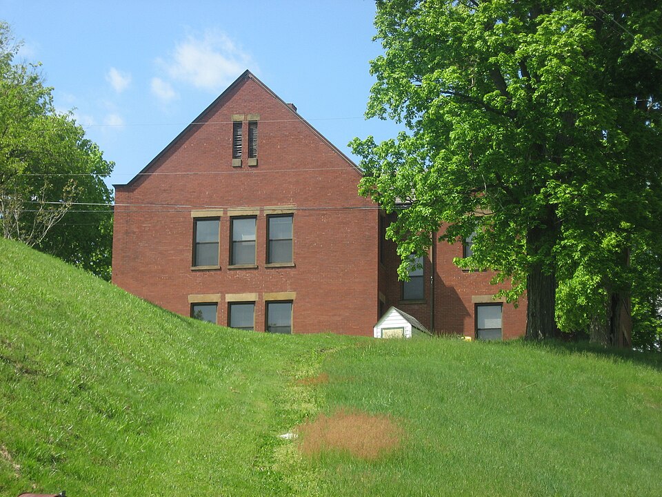
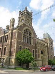
Built in 1904. Listed on the National Register of Historic Places in
1980. A historic map-sheet match is not published yet. The record needs a coordinate-quality review before it can be joined to a sheet boundary.
From the record
“The West School is a historic former school in the village of Crooksville, Ohio, United States. Constructed during a period of significant growth in the community, it served local children for a comparatively short time before its sale for private use.”
Wikipedia article West School (Crooksville, Ohio), CC BY-SA 4.0.
one of 11 National Register listings in Perry County · listed in 1980 · category: Building · built in 1904.
National Register reference number.80003207- the number the National Park Service assigned this property when it was listed, and the key its nomination file is catalogued under at the National Archives.
Fires near this property
39 since 2013
Regional context, not property-specific
evidence. The
federal wildfire occurrence database
lists 39 fires within 5 miles of West School between
2013 and 2019, burning about 203 acres in total. None started naturally. 3 were recorded as arson.
Distance is straight-line from the map coordinates, so a fire counted
here may appear on a neighbouring settlement's page as well.
Reported cause
Fires
Debris and open burning
26
Missing data/not specified/undetermined
6
Arson/incendiarism
3
Equipment and vehicle use
1
Power generation/transmission/distribution
1
Recreation and ceremony
1
Smoking
1
The most recent of
them, most recent first, with the day each was reported and the service
that recorded it.
Regional context, not property-specific
evidence. Museums hold 158 specimens
collected within 10 miles of West School between 1891 and
1975: 141 Animalia, 9 Fungi, 5 Plantae, 2 Unrecorded, 1 Protozoa. 12 distinct Species records are shown.
Collected by Bergstrom, J., Buchanan, J., Buker, W.E. and others. Each is a
physical object with a catalogue
number, and each entry opens the museum's record. This is what was
collected and kept, not a survey of what lives here - nothing can be
concluded from a species being absent.
Regional context, not property-specific
evidence. The federal mineral resources record lists
7 workings within 5 miles of West School: 4 past producers, 3 producers.
3 still produce. What was taken out: Clay, Limestone, General. Distance is straight-line from the
map coordinates, so a quarry counted here may appear on a neighbouring
settlement's page as well.
Regional context, not property-specific
evidence. The National Weather Service names
Crooksville, the town this property stands in, in 27 storm reports between 1994 and 2026: 15 thunderstorm wind, 9 hail, 2 flash flood, 1 funnel cloud.
No death or injury is recorded in these reports. Each account below is quoted exactly as the forecast office
filed it, from the NOAA Storm Events Database, and each date
opens the federal record of that event.
A NWS survey team found that strong straight line winds of 80 to 90 MPH resulted in tree damage to a mixture of softwood and hardwood trees just south of Crooksville. The results of the survey indicated that straight line winds were |responsible for the areas of tree damage noted just south of Crooksville.|Tree damage initially began on either side of Flint Ridge Road, consisting |of a mix of hardwood and softwood trees that were either uprooted or snapped|off. Additionally, a porch awning was lifted up and over a mobile home. Tree|damage continued east-northeast to Tunnel Hill Road across from the water |plant. A narrow swath of significant tree damage was noted, with several large, |healthy softwood trees either uprooted or snapped off. The damage continued |along Ceramic Road, where additional damage occurred to a mix of hardwood and |softwood trees. Notably, a softwood pine was snapped off and landed on a home |on the east side of Ceramic Road. The damage ended just east of Ceramic Road. |All damage along this path was lying in a northeast direction.
No historic map-sheet match is published
for this property yet. That does not mean no map exists. This record needs
a coordinate-quality review before it can be joined to a sheet boundary.
Browse the county's mapped places while that work is
pending.
From the nomination file
1,196 words on record
When this property was proposed for the
National Register, someone wrote the case for it: what the building is,
and why it matters. That document is a federal record in the public domain.
It is quoted below word for word, never summarised. The text was read off the scanned case file by machine, so the
occasional stray character is the recogniser's and the 1970s
typewriter's.
Description of the property
stairs to the raised double doorway have been removed.The highest story of the tower -unexposed Xoriginal site contains an enclosed belfry, with louvered voids. Each of the wings of the ell is trimmed with smooth-dressed stone.A beveled stone beltcourse extends around the entire approximately one hundred yards west of the building.There are no historic outbuild- building at a height just below the first story windows.In addition to voids on the tower set in the angle of the ell. The main entrance to the building is located on this wall.At attic level on each gable end are paired louvered ventilation openings. the crest ofa sharp incline to State Route 93.The village cemetery is 1ocated Areas of Significance-Check and justify below - archeology-historic . conservation .
law _ science _ literature - sculpture - education _ military .social/ _ music X 1800-1899 - philosophy _ theater - 1900- - politics/government - transportation - other (specify) Statement of
Statement of significance
(in one paragraph) this time, Crooksville was rapidly undergoing a population expansion with the estab- lishment of potteries, which still flourish today, and the construction of these two time, during the early 'teens, it also was used as a high school. area, and increased reyenues allowed the village to construct newer facilities, in- Leaf Lodge #678, who used it for their hall until 1978. 1904 1500-1599 1600-1699 1400-1499 1700-1799 commerce communications economics architecture humanitarian Builder/Architect Period industry agriculture prehistoric exploration/settlement unknown art 8.
Significance its counterpart, East School which has been severely altered over the years) was West School is nominated as the only intact vestige of the village of Crooksville Lengineering Specific dates facilities was no doubt intended to meet the needs of the growing village.For a invention - archeology-prehistoric - community planning _ landscape architecture - religion built as a result of the first planned educational expansion of the village.During cluding a high school.In 1929.West School was sold to the Knights of Pythias Oak from the early 20th century.According toa local published history West School 9.
Quoted from the National Register nomination
for reference 80003207, 10 pages, held by the National Archives in Record
Group 79. See the
catalogue record.
Listed places nearby
1 within 8 miles
Other National Register properties close
enough to walk or drive between, ordered by distance from this one. Both
positions come from the same geocoding pass that matched these properties
to their map sheets.
Listing record. National Park Service National Register of Historic Places, listed-properties dataset, current to 2026-05-22.
Map join. Address geocoded through the United States Census geocoder, then tested against the published boundary of every sheet in the USGS Historical Topographic Map Collection.
How this page is made. Listing fields come from federal records; map-sheet coverage is a labelled coordinate-to-boundary calculation, not a source-field claim.
Wildfire. Short, Karen C. 2022. Spatial wildfire occurrence data for the United States, 1992-2020 [FPA_FOD_20221014]. 6th Edition. Fort Collins, CO: Forest Service Research Data Archive. https://doi.org/10.2737/RDS-2013-0009.6 Collected with United States Government funding and usable without additional permissions or fees.
Specimens. Global Biodiversity Information Facility (GBIF), https://www.gbif.org/. Only records licensed CC0 or CC BY are used. Records licensed CC BY-NC are excluded because this site carries advertising. Images are checked individually and any whose licence is non-commercial, no-derivatives or unreadable is refused.
Mines and quarries. USGS Mineral Resources Data System (MRDS) https://mrdata.usgs.gov/mrds/ A work of the United States government, no copyright under 17 U.S.C. 105.
Storms. NOAA National Centers for Environmental Information, Storm Events Database https://www.ncei.noaa.gov/stormevents/ A work of the United States government, no copyright under 17 U.S.C. 105. Narratives are quoted verbatim from the National Weather Service report and are not edited or summarised.
 Block
Block