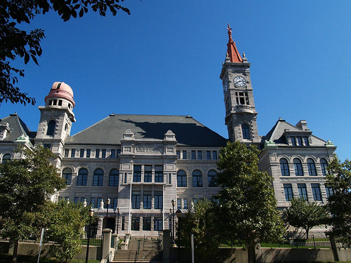
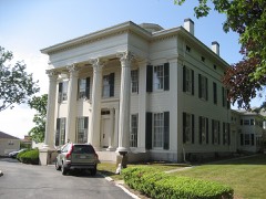
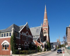
Photograph by Marcbela (Marc N. Belanger), Public domain. Via
Wikimedia Commons.
Durfee, B.M.C., High School
Built in 1886 in the Renaissance Revival architecture. Listed on the National Register of Historic Places in
1981. A historic map-sheet match is not published yet. The record needs a coordinate-quality review before it can be joined to a sheet boundary.
From the record
“Durfee High School is an historic former high school building at 289 Rock Street in Fall River, Massachusetts. The school was built in 1886 and added to the National Register of Historic Places in 1981.”
Wikipedia article B.M.C. Durfee High School (1886 building), CC BY-SA 4.0.
one of 272 National Register listings in Bristol County · listed in 1981 · category: Building · built in 1886, Renaissance Revival architecture · one of 8 National Historic Landmarks in Bristol County.
National Register reference number.81000109- the number the National Park Service assigned this property when it was listed, and the key its nomination file is catalogued under at the National Archives.
Fires near this property
28 since 2001
Regional context, not property-specific
evidence. The
federal wildfire occurrence database
lists 28 fires within 5 miles of Durfee, B.M.C., High School between
2001 and 2020, burning about 56 acres in total. None started naturally. 3 were recorded as arson.
Distance is straight-line from the map coordinates, so a fire counted
here may appear on a neighbouring settlement's page as well.
Reported cause
Fires
Missing data/not specified/undetermined
13
Debris and open burning
6
Misuse of fire by a minor
3
Arson/incendiarism
3
Recreation and ceremony
1
Power generation/transmission/distribution
1
Equipment and vehicle use
1
The most recent of
them, most recent first, with the day each was reported and the service
that recorded it.
Regional context, not property-specific
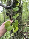
evidence. Museums hold 1,060 specimens
collected within 10 miles of Durfee, B.M.C., High School between 1844 and
1975: 582 Animalia, 368 Plantae, 77 Fungi, 29 Chromista, 4 Unrecorded. 12 distinct Species records are shown.
Collected by A E Schuyler, A. B. Hervey, A. Macrae and others. Each is a
physical object with a catalogue
number, and each entry opens the museum's record. This is what was
collected and kept, not a survey of what lives here - nothing can be
concluded from a species being absent.
Regional context, not property-specific
evidence. The federal mineral resources record lists
2 workings within 5 miles of Durfee, B.M.C., High School: 1 unknown, 1 plant.
1 still produces. What was taken out: Stone, Crushed/Broken, Sand and Gravel, Construction. Distance is straight-line from the
map coordinates, so a quarry counted here may appear on a neighbouring
settlement's page as well.
Regional context, not property-specific
evidence. The National Weather Service names
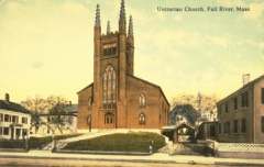
Fall River, the town this property stands in, in 24 storm reports between 1997 and 2025: 10 flood, 5 thunderstorm wind, 5 flash flood, 2 hail.
No death or injury is recorded in these reports. Each account below is quoted exactly as the forecast office
filed it, from the NOAA Storm Events Database, and each date
opens the federal record of that event.
At 1:25 PM EST, several cars were trapped in flood waters on Quequechan Street and Warren Street, near a Walmart store. The two streets were closed due to flooding.
Warren Street was flooded and impassable. A car was stuck in flood waters on Pleasant Street at the intersection with Quarry Street. Manhole covers popped off due to flooding on Globe Street.
No historic map-sheet match is published
for this property yet. That does not mean no map exists. This record needs
a coordinate-quality review before it can be joined to a sheet boundary.
Browse the county's mapped places while that work is
pending.
From the nomination file
2,572 words on record
When this property was proposed for the
National Register, someone wrote the case for it: what the building is,
and why it matters. That document is a federal record in the public domain.
It is quoted below word for word, never summarised. The text was read off the scanned case file by machine, so the
occasional stray character is the recogniser's and the 1970s
typewriter's.
Description of the property
B.M.C Durfee High School is an imposing three and a half story granite building occupying an entire city block bounded by Rock, Cherry, High, and Locust Streets. Erected in 1886 from designs by George A. Clough, Durfee High School is prominently situated near the proposed Highlands Historic District overlooking Mt. Hope Bay, just north of downtown Fall Its setting, together with a steep hippedroofand five story clock-tower, make the structure a dominant element in the landscape and a key Fall River landmark. The most concise description of the building was that written by the architect upon its opening and published three years later in B.M.C. Durfee High School, Fall River, MA, Fall River, 1889. It is still remarkably accurate. .
hat er tgn benthc tchi ecr up, The building occupies a commanding position, with spacious grounds about it. The area of the building is 20,500 feet. The exterior walls of all four elevations are built of granite, surmount ed with steep plated roofs, and the whole treated in a modern ren- aissance style. The principal features of the architecture are brought out in a clock-tower an observatory tower, and a central pavilion with steep roofs. The main features (two towers and central pavilion) are arranged across the front, between heavy projecting end pavilions, and are tied together at the bottom, from one to the other, with a massive The clock tower at the south end is mainly of granite, terminating with a copper spire or finial.
The clock dial is 114 feet above the grade; below, and yet above the roofs, is an open belfry with a chime of bells. The north tower occupies a symmetrical position with that of the south, but is of less height and is surmounted with an astronomical cupola, fitted with telescope.
/Architect George A. Clough, architect Norcross Brothers, builders Statement of Significance (in one paragraph) The B.M.C. Durfee High School, designed by Boston architect George Clough, possesses ESEEE integrity of location, design, setting, materials, and workmanship. In the quality of design and materials, it is emblematic of late nineteenth century Fall River's wealth and civic pride and reflects the city's commitment to meet the educational In addition to its civic and architectural significance, the school also has strong associations with one of Fall River's most important families; the Durfee's. Thus the school meets criteria A, B, and C of the The building was given by Mary Brayton Durfee Young in memory of her son, Bradford . Mathew Chaloner Durfee.
Durfee, a native of Fall River and area resident, died in 1872, at the age of twenty-nine. The Durfee family was prominent in the establishment of Fall River's industrial base with the establishment of the Fall River Iron Works in 1821. In giving the building, Mrs. Young was responding both to the needs of the city, whose thirty-year old high school was overcrowded and about to be enlarged, and to the desires of her son, who hoped that his estate might assist the youth of the city to be instructed in the "chemical, physical, and mechanical sciences, which enter so largely into the industries of Fall River." Thus, the school was endowed by Mrs. Young with $50,000 for these puxposes.
The principal orator at the dedication on June 15, 1887 (the 44th anniversary of Durfee's birth) was Reverend Roswell D. Hitchcock, President of the Union Theological Seminary in New York, who summed up the special role that Durfee High School would play in the life of Fall River.
Quoted from the National Register nomination
for reference 81000109, 12 pages, held by the National Archives in Record
Group 79. See the
catalogue record.
Listed places nearby
6 within 8 miles
Other National Register properties close
enough to walk or drive between, ordered by distance from this one. Both
positions come from the same geocoding pass that matched these properties
to their map sheets.
Listing record. National Park Service National Register of Historic Places, listed-properties dataset, current to 2026-05-22.
Map join. Address geocoded through the United States Census geocoder, then tested against the published boundary of every sheet in the USGS Historical Topographic Map Collection.
How this page is made. Listing fields come from federal records; map-sheet coverage is a labelled coordinate-to-boundary calculation, not a source-field claim.
Wildfire. Short, Karen C. 2022. Spatial wildfire occurrence data for the United States, 1992-2020 [FPA_FOD_20221014]. 6th Edition. Fort Collins, CO: Forest Service Research Data Archive. https://doi.org/10.2737/RDS-2013-0009.6 Collected with United States Government funding and usable without additional permissions or fees.
Specimens. Global Biodiversity Information Facility (GBIF), https://www.gbif.org/. Only records licensed CC0 or CC BY are used. Records licensed CC BY-NC are excluded because this site carries advertising. Images are checked individually and any whose licence is non-commercial, no-derivatives or unreadable is refused.
Mines and quarries. USGS Mineral Resources Data System (MRDS) https://mrdata.usgs.gov/mrds/ A work of the United States government, no copyright under 17 U.S.C. 105.
Storms. NOAA National Centers for Environmental Information, Storm Events Database https://www.ncei.noaa.gov/stormevents/ A work of the United States government, no copyright under 17 U.S.C. 105. Narratives are quoted verbatim from the National Weather Service report and are not edited or summarised.
 Block
Block