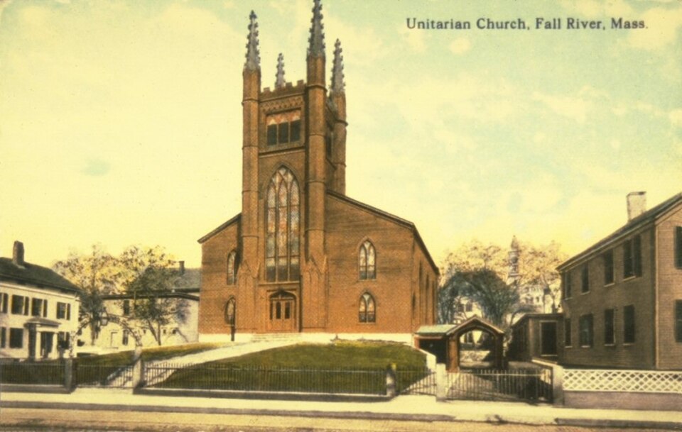
Photograph by Unknown author Unknown author, Public domain. Via
Wikimedia Commons.
Unitarian Society, The
Listed on the National Register of Historic Places in
1982. A historic map-sheet match is not published yet. The record needs a coordinate-quality review before it can be joined to a sheet boundary.
From the record
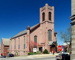
“The Unitarian Society was a historic church building located in Fall River, Massachusetts.”
Wikipedia article Unitarian Society (Fall River), CC BY-SA 4.0.
one of 272 National Register listings in Bristol County · listed in 1982 · category: Building · one of 8 National Historic Landmarks in Bristol County.
National Register reference number.82004958- the number the National Park Service assigned this property when it was listed, and the key its nomination file is catalogued under at the National Archives.
Fires near this property
26 since 2002
Regional context, not property-specific
evidence. The
federal wildfire occurrence database
lists 26 fires within 5 miles of Unitarian Society, The between
2002 and 2020, burning about 54 acres in total. None started naturally. 3 were recorded as arson.
Distance is straight-line from the map coordinates, so a fire counted
here may appear on a neighbouring settlement's page as well.
Reported cause
Fires
Missing data/not specified/undetermined
12
Debris and open burning
6
Arson/incendiarism
3
Misuse of fire by a minor
2
Recreation and ceremony
1
Power generation/transmission/distribution
1
Equipment and vehicle use
1
The most recent of
them, most recent first, with the day each was reported and the service
that recorded it.
Regional context, not property-specific
evidence. Museums hold 1,057 specimens
collected within 10 miles of Unitarian Society, The between 1844 and
1975: 582 Animalia, 365 Plantae, 77 Fungi, 29 Chromista, 4 Unrecorded. 12 distinct Species records are shown.
Collected by A E Schuyler, A. B. Hervey, A. Macrae and others. Each is a
physical object with a catalogue
number, and each entry opens the museum's record. This is what was
collected and kept, not a survey of what lives here - nothing can be
concluded from a species being absent.
Regional context, not property-specific
evidence. The federal mineral resources record lists
2 workings within 5 miles of Unitarian Society, The: 1 unknown, 1 plant.
1 still produces. What was taken out: Stone, Crushed/Broken, Sand and Gravel, Construction. Distance is straight-line from the
map coordinates, so a quarry counted here may appear on a neighbouring
settlement's page as well.
Regional context, not property-specific
evidence. The National Weather Service names
Fall River, the town this property stands in, in 24 storm reports between 1997 and 2025: 10 flood, 5 thunderstorm wind, 5 flash flood, 2 hail.
No death or injury is recorded in these reports. Each account below is quoted exactly as the forecast office
filed it, from the NOAA Storm Events Database, and each date
opens the federal record of that event.
At 1:25 PM EST, several cars were trapped in flood waters on Quequechan Street and Warren Street, near a Walmart store. The two streets were closed due to flooding.
Warren Street was flooded and impassable. A car was stuck in flood waters on Pleasant Street at the intersection with Quarry Street. Manhole covers popped off due to flooding on Globe Street.
No historic map-sheet match is published
for this property yet. That does not mean no map exists. This record needs
a coordinate-quality review before it can be joined to a sheet boundary.
Browse the county's mapped places while that work is
pending.
From the nomination file
2,144 words on record
When this property was proposed for the
National Register, someone wrote the case for it: what the building is,
and why it matters. That document is a federal record in the public domain.
It is quoted below word for word, never summarised. The text was read off the scanned case file by machine, so the
occasional stray character is the recogniser's and the 1970s
typewriter's.
Description of the property
The Unitarian Society of Fall River, founded in 1832, constructed their Gothic Revival style church in 1835 at the southeast corner of Borden and Second Streets. The after- math of Fall River's 1843 fire, which changed the character of the area surrounding the church, resulted in its removal, in numbered pieces, to its present site at 309 North Main Street in 1860. The church of the Unitarian Society in Fall River is wood frame construction with clapboard sheathing. In form it is a simple rectangular block topped by a broad pitched roof and fronted by a square central tower divided horizontally into three stages. In overall design, therefore, the church adheres closely to the New EngLand tradition of colonial meeting house construction which preceeded it.
In detail, however, it is Gothic Revival. Double and triple lancet windows. both in the body of the church and in the tower are capped by Gothic label, or hood, moldings. The corners of the square tower are defined by smaller, engaged polygonal towers topped by crocketted spires. The first stage of the tower contains a slightly recessed center entrance framed by a 4-centered, pointed arch supported on clustered, engaged colônettes. Above this arch a flat label moulding joins with the projecting molded course above it to define the upper limit of the first stage and the base, or sill, of the second stage of the tower. This is occupied by a triple lancet window which rises to a point above the ridge of the church roof.
A belfry in which hangs a Paul Revere bell comprises the uppermost stage of the tower. Tripartite louvered panels in each wall of the belfry are Gothic-arched and capped by a flat label molding. Gothic ornamentation also comprises the base of each panel.
/Architect NA Statement of Significance (in one paragraph) The church of the Unitarian Society in Fall River possesses integrity of location, design, materials, and workmanship, and with its traditional colonial meeting house form overlaid with Gothic Revival detail, is a very good example of the type of church structure which began to be built in New England during the late 1820s. This church, with the others like it, 1ooked both backward and forward stylistically when it was constructed in 1835. ,Said to be a copy of the Pilgrims' Church in Plymouth, Massachusetts (destroyed by fire in the late nineteenth century), the Unitarian Society's meeting house is the oldest church building in Fall River that continues to be occupied by the denomination which erected it.
The Unitarian Society in Fall River was founded in 1832 by people dissatisfied with the narrowness and spiritual orthodoxy of the five churches already existing in the commmity. Many even walked as far as Newport, Rhode Island to hear Dr. William E. Channing speak. Noteworthy among the ministers to the Unitarian Society's Fall River church was the Reverend Samuel Longfellow, brother of Henry Wadsworth Longfellow. During his ministry from 1848 to 1851, Longfellow was also chairman of the Fall River School Committee and influential in the establishment of the city's public high school. The Reverend Joshua loung, minister from 1868 to 1875, was known for having preached John Brown's funeral sermon after he was executed at Charlestown, Virginia in 1859.
Some of the great preachers of New England have also spoken from the Unitarian Society pulpit: the Reverend James Freeman Clark; the Reverend Edward Everett Hale; and Harvard's Dr. Samuel Eliot.
Quoted from the National Register nomination
for reference 82004958, 12 pages, held by the National Archives in Record
Group 79. See the
catalogue record.
Listed places nearby
6 within 8 miles
Other National Register properties close
enough to walk or drive between, ordered by distance from this one. Both
positions come from the same geocoding pass that matched these properties
to their map sheets.
Listing record. National Park Service National Register of Historic Places, listed-properties dataset, current to 2026-05-22.
Map join. Address geocoded through the United States Census geocoder, then tested against the published boundary of every sheet in the USGS Historical Topographic Map Collection.
How this page is made. Listing fields come from federal records; map-sheet coverage is a labelled coordinate-to-boundary calculation, not a source-field claim.
Wildfire. Short, Karen C. 2022. Spatial wildfire occurrence data for the United States, 1992-2020 [FPA_FOD_20221014]. 6th Edition. Fort Collins, CO: Forest Service Research Data Archive. https://doi.org/10.2737/RDS-2013-0009.6 Collected with United States Government funding and usable without additional permissions or fees.
Specimens. Global Biodiversity Information Facility (GBIF), https://www.gbif.org/. Only records licensed CC0 or CC BY are used. Records licensed CC BY-NC are excluded because this site carries advertising. Images are checked individually and any whose licence is non-commercial, no-derivatives or unreadable is refused.
Mines and quarries. USGS Mineral Resources Data System (MRDS) https://mrdata.usgs.gov/mrds/ A work of the United States government, no copyright under 17 U.S.C. 105.
Storms. NOAA National Centers for Environmental Information, Storm Events Database https://www.ncei.noaa.gov/stormevents/ A work of the United States government, no copyright under 17 U.S.C. 105. Narratives are quoted verbatim from the National Weather Service report and are not edited or summarised.
 Block
Block