Listed on the National Register of Historic Places in
1980. A historic map-sheet match is not published yet. The record needs a coordinate-quality review before it can be joined to a sheet boundary.
From the record
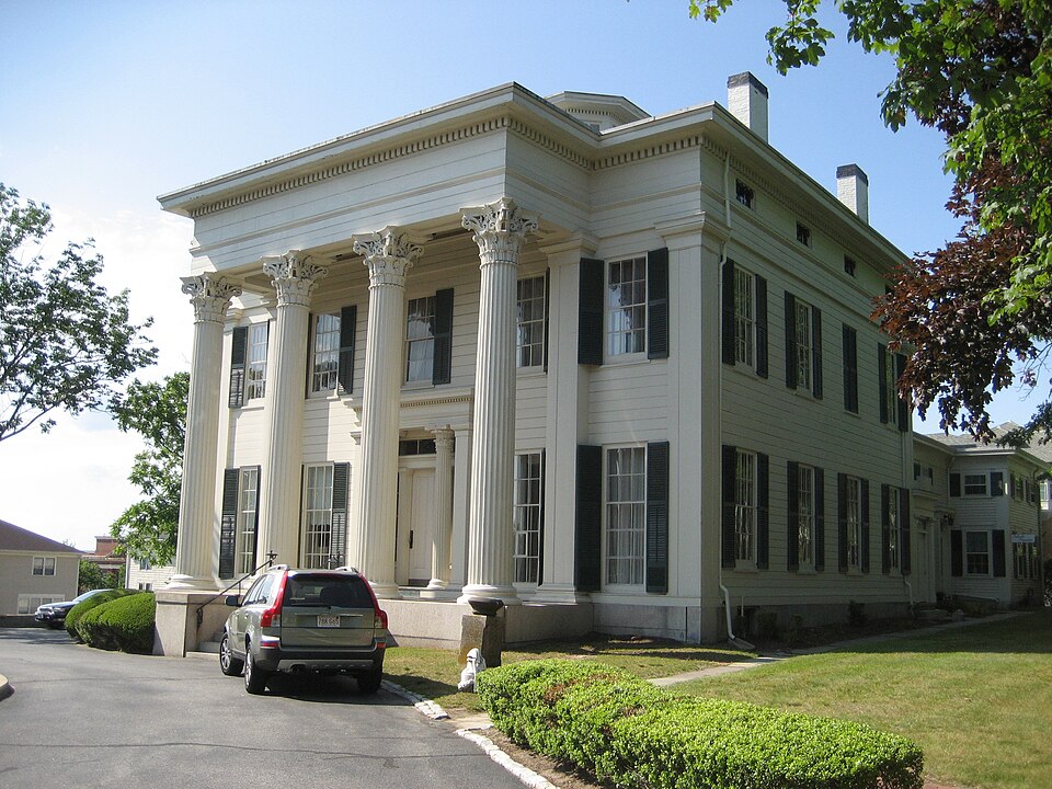
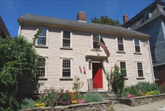
“The Osborn House is a historic house at 456 Rock Street in Fall River, Massachusetts, built in the Greek Revival style.”
Wikipedia article Osborn House, CC BY-SA 4.0.
one of 272 National Register listings in Bristol County · listed in 1980 · category: Building · one of 8 National Historic Landmarks in Bristol County.
National Register reference number.80000431- the number the National Park Service assigned this property when it was listed, and the key its nomination file is catalogued under at the National Archives.
Fires near this property
27 since 2001
Regional context, not property-specific
evidence. The
federal wildfire occurrence database
lists 27 fires within 5 miles of Osborn House between
2001 and 2020, burning about 55 acres in total. None started naturally. 3 were recorded as arson.
Distance is straight-line from the map coordinates, so a fire counted
here may appear on a neighbouring settlement's page as well.
Reported cause
Fires
Missing data/not specified/undetermined
13
Debris and open burning
6
Arson/incendiarism
3
Misuse of fire by a minor
2
Recreation and ceremony
1
Power generation/transmission/distribution
1
Equipment and vehicle use
1
The most recent of
them, most recent first, with the day each was reported and the service
that recorded it.
Regional context, not property-specific
evidence. Museums hold 1,057 specimens
collected within 10 miles of Osborn House between 1844 and
1975: 583 Animalia, 364 Plantae, 77 Fungi, 29 Chromista, 4 Unrecorded. 12 distinct Species records are shown.
Collected by A E Schuyler, A. B. Hervey, A. Macrae and others. Each is a
physical object with a catalogue
number, and each entry opens the museum's record. This is what was
collected and kept, not a survey of what lives here - nothing can be
concluded from a species being absent.
Regional context, not property-specific
evidence. The federal mineral resources record lists
2 workings within 5 miles of Osborn House: 1 unknown, 1 plant.
1 still produces. What was taken out: Stone, Crushed/Broken, Sand and Gravel, Construction. Distance is straight-line from the
map coordinates, so a quarry counted here may appear on a neighbouring
settlement's page as well.
Regional context, not property-specific
evidence. The National Weather Service names
Fall River, the town this property stands in, in 24 storm reports between 1997 and 2025: 10 flood, 5 thunderstorm wind, 5 flash flood, 2 hail.
No death or injury is recorded in these reports. Each account below is quoted exactly as the forecast office
filed it, from the NOAA Storm Events Database, and each date
opens the federal record of that event.
At 1:25 PM EST, several cars were trapped in flood waters on Quequechan Street and Warren Street, near a Walmart store. The two streets were closed due to flooding.
Warren Street was flooded and impassable. A car was stuck in flood waters on Pleasant Street at the intersection with Quarry Street. Manhole covers popped off due to flooding on Globe Street.
No historic map-sheet match is published
for this property yet. That does not mean no map exists. This record needs
a coordinate-quality review before it can be joined to a sheet boundary.
Browse the county's mapped places while that work is
pending.
From the nomination file
2,002 words on record
When this property was proposed for the
National Register, someone wrote the case for it: what the building is,
and why it matters. That document is a federal record in the public domain.
It is quoted below word for word, never summarised. The text was read off the scanned case file by machine, so the
occasional stray character is the recogniser's and the 1970s
typewriter's.
Description of the property
The Durfee-Carr-Osborn House occupies a lot at the southwest corner of Rock and Maple Streets in "the Hill" section of Fall River. An elaborate example of Greek Revival style architecture, thehouseismade upof a three-story main houseandone-and-one-half story rear ell, both of wooden construction. The main house is nearly square in plan (45'X 50') with four interior end-wall chimneys. The structure rises from a foundation of hammered granite ashlar to a low hip root. All elev- ations are faced with matched boarding, the horizontal joints of which have been scored. The corners of the main house are framed by Doric pilasters which support a wide frieze and a dentilled cornice. except for the first story windows of the facade (south elevation) which contain floor-to- ceiling 6/9 sash.
Centered on the roof of the main house is an octagonal cupola, each face of which contains a four-pane casement window. The cupola is enclosed by a nearly flat roof, which projects far out over the body of the cupola to form a dees cornice. The facade (south elevation) is perpendicular to Rock Street and is approached from a circular driveway. It is symmetrical, having at its center a monumental Corinthinian portico of three bays' length and one bay's depth. Where this portico is joined to the facade, it is supported by Doric pilasters. Set behind the portico's center bay, the house's main entry is framed by Doric pilasters and an entablature. Standing in antis are two fluted columns with acanthus and palm-leaf capitals.
The door itself, is surrounded by rectangular sidelights and a rectangular transom. Fenestration of the facade consists of four windows at the first story and five at the second. The east elevation faces Rock Street and contains four évenly spaced windows at both the first and second stories.
(in one paragraph) Builder/Architect Russell Warren of Providence, architect The Durfee-Carr-Osborn House possesses integrity of location, design, setting and materials as well as historical associations with several of Fall River's leading nineteenth-century industrialists and with the establishment of "the Hill" as a wealthy residential district during the mid-nineteenth century. One of three houses designed by Russell Warren and built for members of the Borden-Durfee family in th early 1840's, the Durfee-Carr-Osborn House is the last of the three extant and remains Fall River's most elaborate example of Greek Revival architecture.
As one of the first houses built on "the Hill" (referred to as "the Highlands") overlooking Fall River's center, the Durfee-Carr-Osborn House was sited so that its facade faced a terraced lawn and, more distantly, Fall River center and Mt. Hope Bay. At present, the house remains in nearly original condition, both inside and out. The house's original owner, for whom it was designed, was Joseph Durfee, whose Massasoit and Wamsutta Mills; in addition, he served on the boards of directors of daughter, Elizabeth, and her-husband, Willian Carr, who occupied the property for more that fifty years. After 1880, the house was also occupied by the Carr's daughter and her husband, James Osborn.
Osborn was prominent in the City's textile (1896-1898) and treasurer of the Merchant's Manufacturing Company; the latter two his daughter, Elizabeth and her husband, Leeds Burchard. In 1951, the house was sold and converted to aparish house for the adjacent Presbyterian Church. In 1977, the property was sold to its current owners who con- verted it back to a single-family residence. The house is currently being restored based, in part, on the Durfee-Carr-Osborn family photographs and on some original furnishings which have been found in storage in the house.
Quoted from the National Register nomination
for reference 80000431, 13 pages, held by the National Archives in Record
Group 79. See the
catalogue record.
Listed places nearby
6 within 8 miles
Other National Register properties close
enough to walk or drive between, ordered by distance from this one. Both
positions come from the same geocoding pass that matched these properties
to their map sheets.
Listing record. National Park Service National Register of Historic Places, listed-properties dataset, current to 2026-05-22.
Map join. Address geocoded through the United States Census geocoder, then tested against the published boundary of every sheet in the USGS Historical Topographic Map Collection.
How this page is made. Listing fields come from federal records; map-sheet coverage is a labelled coordinate-to-boundary calculation, not a source-field claim.
Wildfire. Short, Karen C. 2022. Spatial wildfire occurrence data for the United States, 1992-2020 [FPA_FOD_20221014]. 6th Edition. Fort Collins, CO: Forest Service Research Data Archive. https://doi.org/10.2737/RDS-2013-0009.6 Collected with United States Government funding and usable without additional permissions or fees.
Specimens. Global Biodiversity Information Facility (GBIF), https://www.gbif.org/. Only records licensed CC0 or CC BY are used. Records licensed CC BY-NC are excluded because this site carries advertising. Images are checked individually and any whose licence is non-commercial, no-derivatives or unreadable is refused.
Mines and quarries. USGS Mineral Resources Data System (MRDS) https://mrdata.usgs.gov/mrds/ A work of the United States government, no copyright under 17 U.S.C. 105.
Storms. NOAA National Centers for Environmental Information, Storm Events Database https://www.ncei.noaa.gov/stormevents/ A work of the United States government, no copyright under 17 U.S.C. 105. Narratives are quoted verbatim from the National Weather Service report and are not edited or summarised.
 Block
Block