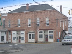
Listed on the National Register of Historic Places in
1982. A historic map-sheet match is not published yet. The record needs a coordinate-quality review before it can be joined to a sheet boundary.
From the record
one of 11 National Register listings in Ashland County · listed in 1982 · category: Building.
National Register reference number.82003538- the number the National Park Service assigned this property when it was listed, and the key its nomination file is catalogued under at the National Archives.
Regional context, not property-specific
evidence. Museums hold 302 specimens
collected within 10 miles of Lakefork School between 1896 and
1975: 268 Animalia, 34 Plantae. 12 distinct Species records are shown.
Collected by B.H., L.A. & H.H., B.H., M.H. & H.P., Collector(s): Edwin Lincoln Moseley and others. Each is a
physical object with a catalogue
number, and each entry opens the museum's record. This is what was
collected and kept, not a survey of what lives here - nothing can be
concluded from a species being absent.
Regional context, not property-specific
evidence. The National Weather Service names
Jeromesville, the town this property stands in, in 15 storm reports between 1998 and 2022: 7 thunderstorm wind, 5 hail, 2 flood, 1 flash flood.
No death or injury is recorded in these reports. Each account below is quoted exactly as the forecast office
filed it, from the NOAA Storm Events Database, and each date
opens the federal record of that event.
Thunderstorm winds estimated at nearly 60 mph severely damaged a pole barn. Debris from the barn was spread out over an 80 yard area and also forced the closure of a road nearby.
There were several reports from both law enforecement and trained spotters in Jeromesville of thunderstorm wind damage. Many trees were reported down along with power lines. A trained spotter reported a tree down on a building causing roof damage.
Multiple roads flooded and impassable across the county due to flooding. Brookside Drive flooded by swift water from the Town Run Creek on the west side of Ashland. Highway 250 near Jeromesville flooded and SR 302. Grandpa's Cheesebarn and Sweeties Chocolates closed due to flooding. Flooding at residences reported in Ashland.
Several roads flooded across the southern portions of the county on April 4. Rainfall amounts over southern Ashland County was around 1 to 2 inches. However, heavier rainfall amounts fell in the headwaters of the Mohican River in Richland County where observers measured closer to 3 inches of rain. The Black Fork Mohican River at Loudonville came out of banks on April 4th flooding numerous campgrounds and recreational areas. Due to the seasonal variability of the population, the impacts were limited. The Jerome Fork and Glenn Run creeks flooded portions of CR 1950. The most notable damage occurred in Jeromesville on County Road 1950 just east of CR 175 were a large section of a road bank was eroded.
Rainfall through the evening hours of the 31st across central portions of the county lead to the closure of two county roads around Jeromesville due to high water.
No historic map-sheet match is published
for this property yet. That does not mean no map exists. This record needs
a coordinate-quality review before it can be joined to a sheet boundary.
Browse the county's mapped places while that work is
pending.
From the nomination file
2,772 words on record
When this property was proposed for the
National Register, someone wrote the case for it: what the building is,
and why it matters. That document is a federal record in the public domain.
It is quoted below word for word, never summarised. The text was read off the scanned case file by machine, so the
occasional stray character is the recogniser's and the 1970s
typewriter's.
Description of the property
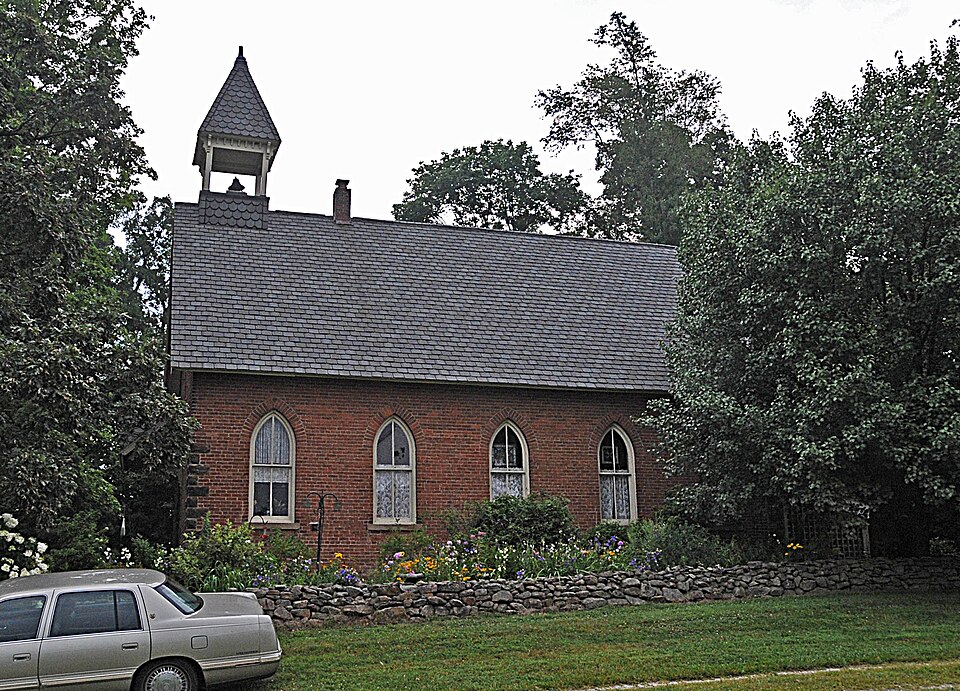
gable end is the bell tower rising 60 feet above the ground.This delicate tower retains larly to that of the quoins and larger red streaked sandstone forming a Gothic arch. bond is accented at each of the four corners with rough cut stone quoins rising 3/4of just to the southeast. -deteriorated _ unaltered _fair Wainscoating covers the walls of the entryway. X good date with composite shingles due to its deteriorated condition.A primary feature of the This material can also be Areas of Significance - Check and justify below - prehistoric - archeology-prehistoric - community planning - archeology-historic - conservation . law - science - agriculture - economics .
literature - sculpture X architecture X education .military _ social/ .art - engineering - music X 1800-1899 - exploration/settlement - philosophy _ theater - industry - politics/government _ transportation _ invention - other (specify) Statement of
Statement of significance
(in one paragraph) school's main stylistic features, lancet windows, bell tower and entrance arch make a 1600-1699 1400-1499 1700-1799 Builder/Architect 1500-1599 communications humanitarian Period commerce 1900- 8. Significance and one of the country's most substantial and best preserved one room schoolhouses.The fine example of a Victorian Gothic school building.This late nineteenth century structure The Lakefork School is significant as a fine example of Victorian.Gothic architecture walls.The single room is 36 feet by 42 feet with a raised teacher's platform across the front.The present owners have been attempting to maintain the integrity of the school.
is the only one of its kind standing in tact and altered only slightly.A simi- lar structure, a few miles away, stands in near ruin. The Lakefork school was permanently Specific dates circa 1880 closed in 1938.The interior is stripped but retains the natural wainscoating and plaster 1874, Atlas of Ashland County. - Letters received by present owner. UMT References northeast corner of intersecting Co. 175 and Twp. 75 in Mohican Township, and the lot contains one building, the Lakefork School.
- state Wendy Leigh Barlow (419) 755-4011 city or town Ohio 44906 The evaluated significance of this property within the state is: _ national 665), I hereby nominate this property for inclusion in the Nafional Register and certify that it has been evaluated State Historic Preservation Officer signature I hereby certify that this property is included in the National Register Chief of Registration code county date Easting Northing Zone Mansfield telephone 1:24,000 Verbal boundary description and justification Ohio 12. State Historic Preservation Officer Certification 11.
Quoted from the National Register nomination
for reference 82003538, 21 pages, held by the National Archives in Record
Group 79. See the
catalogue record.
Listed places nearby
4 within 8 miles
Other National Register properties close
enough to walk or drive between, ordered by distance from this one. Both
positions come from the same geocoding pass that matched these properties
to their map sheets.
Listing record. National Park Service National Register of Historic Places, listed-properties dataset, current to 2026-05-22.
Map join. Address geocoded through the United States Census geocoder, then tested against the published boundary of every sheet in the USGS Historical Topographic Map Collection.
How this page is made. Listing fields come from federal records; map-sheet coverage is a labelled coordinate-to-boundary calculation, not a source-field claim.
Specimens. Global Biodiversity Information Facility (GBIF), https://www.gbif.org/. Only records licensed CC0 or CC BY are used. Records licensed CC BY-NC are excluded because this site carries advertising. Images are checked individually and any whose licence is non-commercial, no-derivatives or unreadable is refused.
Storms. NOAA National Centers for Environmental Information, Storm Events Database https://www.ncei.noaa.gov/stormevents/ A work of the United States government, no copyright under 17 U.S.C. 105. Narratives are quoted verbatim from the National Weather Service report and are not edited or summarised.
 Block
Block