Listed on the National Register of Historic Places in
1982. A historic map-sheet match is not published yet. The record needs a coordinate-quality review before it can be joined to a sheet boundary.
From the record
one of 7 National Register listings in Hocking County · listed in 1982 · category: Building.
Architectural style. Queen Anne style architecture in the United States
National Register reference number.82003598- the number the National Park Service assigned this property when it was listed, and the key its nomination file is catalogued under at the National Archives.
Fires near this property
87 since 1993
Regional context, not property-specific
evidence. The
federal wildfire occurrence database
lists 87 fires within 5 miles of Woodruff, William H., House between
1993 and 2020, burning about 114 acres in total. None started naturally. 2 were recorded as arson.
Distance is straight-line from the map coordinates, so a fire counted
here may appear on a neighbouring settlement's page as well.
Reported cause
Fires
Recreation and ceremony
36
Debris and open burning
32
Missing data/not specified/undetermined
9
Power generation/transmission/distribution
3
Equipment and vehicle use
3
Arson/incendiarism
2
Other causes
2
The most recent of
them, most recent first, with the day each was reported and the service
that recorded it.
Regional context, not property-specific
evidence. Museums hold 1,760 specimens
collected within 10 miles of Woodruff, William H., House between 1874 and
1975: 1,345 Animalia, 296 Plantae, 85 Fungi, 34 Protozoa. 12 distinct Species records are shown.
Collected by A. N. Bragg, Aaron J. Sharp, B. Fink and others. Each is a
physical object with a catalogue
number, and each entry opens the museum's record. This is what was
collected and kept, not a survey of what lives here - nothing can be
concluded from a species being absent.
Regional context, not property-specific
evidence. The federal mineral resources record lists
12 workings within 5 miles of Woodruff, William H., House: 8 past producers, 4 producers.
4 still produce. What was taken out: Sand and Gravel, Construction, Brick Clay, Clay, Fire Clay (Refractory). Distance is straight-line from the
map coordinates, so a quarry counted here may appear on a neighbouring
settlement's page as well.
Regional context, not property-specific
evidence. The National Weather Service names
Logan, the town this property stands in, in 71 storm reports between 1994 and 2026: 47 thunderstorm wind, 10 hail, 10 flood, 3 flash flood.
The reports record 10 injuries. Each account below is quoted exactly as the forecast office
filed it, from the NOAA Storm Events Database, and each date
opens the federal record of that event.
3 papers published in this town,
digitised by the Library of Congress and free to read: 0 issues,
0 pages. Every page is searchable, so a name or a street can be
looked for directly in what the town printed about itself at the time.
No historic map-sheet match is published
for this property yet. That does not mean no map exists. This record needs
a coordinate-quality review before it can be joined to a sheet boundary.
Browse the county's mapped places while that work is
pending.
From the nomination file
1,937 words on record
When this property was proposed for the
National Register, someone wrote the case for it: what the building is,
and why it matters. That document is a federal record in the public domain.
It is quoted below word for word, never summarised. The text was read off the scanned case file by machine, so the
occasional stray character is the recogniser's and the 1970s
typewriter's.
Description of the property
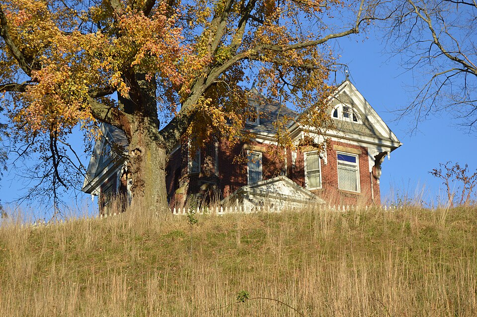
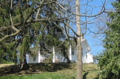
The W. H. Woodruff House sits on a high hill overlooking the Hocking Valley east of on the turret which along with a dome had to be removed due to deterioration. The front part of the house has a three part entablature with scroll brackets and pendant. Three elevations of the building contain set-out brick designs, and the west side board as the house. A frame barn is found to the rear. The house was carpeted when constructed. It contains 1l rooms and two background for the glass lighting fixtures now electrified. All woodwork is intact. The stairway from the reception hall features an oak carved newel post with a in appearance with tile imported from Czechoslovakia on the bottom and beveled glass mirrors above. Two massive sets of sliding wood doors are still in place.
Condition moved ruins fair decorative brass doorknobs is intact.The basement contains five rooms. have stained rose colored glass transom lights.Windows feature arched head and stone The house has the original plaster ceiling moldings in geometricdesigns which were a Check one - unexposed is covered with slate. The only visible outside change is omission of the steeple ornate Eastlake type open frame porch on the facade features an open frieze. The features a lattice work design with the initials "WHW" in brick. Several windows large halls, seven fireplaces and 62 windows. The ceilings are eleven feet high on the first and ten feet high on the second floor.
All original hardware, such as A brick smokehouse/outhouse features the same building style with decorative barge- deteriorated lintels. - good 8.
Statement of significance
(in one paragraph) on the house is the turret on the southwest fine landscape architecture - religion E. P. Jackson & Son inent Hocking County citizen and as an outstanding architectural example in the economy was predominantly supported by agriculture in the 19th century.Because of the modest in scale and less pretentious stylistically. It is set on top of a hill over- looking the Hocking Valley and the site of the Hocking Canal. The attention to detail and was the largest landowner in the county.
His obituary states that he was engaged and stairway are a reflection of the high level of prosperity the Woodruff family Builder/Architect art The Woodruff House is located in Green Twp just east of Logan.Hocking County's Acreage of nominated property Approximately 5 acres Quadrangle name _Gore UMT References Verbal boundary description and justification List all states and counties for properties overlapping state or county boundaries _ state Mrs.
Helen Mowrey/Kathleen Andrews Ohio University/ SORHAPO July 2, 1981 street & number city or town The evaluated significance of this property within the state is: _ national As the designated State Historic Preservation Officer for the National Historic Preservation Act of 1966 (Public Law 89 665), I hereby nominate this property for inclusion in the National Register and certify that it has been evaluated State Historic Preservation Officer signature GPO 938 835 11.
Quoted from the National Register nomination
for reference 82003598, 22 pages, held by the National Archives in Record
Group 79. See the
catalogue record.
Listed places nearby
6 within 8 miles
Other National Register properties close
enough to walk or drive between, ordered by distance from this one. Both
positions come from the same geocoding pass that matched these properties
to their map sheets.
Listing record. National Park Service National Register of Historic Places, listed-properties dataset, current to 2026-05-22.
Map join. Address geocoded through the United States Census geocoder, then tested against the published boundary of every sheet in the USGS Historical Topographic Map Collection.
How this page is made. Listing fields come from federal records; map-sheet coverage is a labelled coordinate-to-boundary calculation, not a source-field claim.
Wildfire. Short, Karen C. 2022. Spatial wildfire occurrence data for the United States, 1992-2020 [FPA_FOD_20221014]. 6th Edition. Fort Collins, CO: Forest Service Research Data Archive. https://doi.org/10.2737/RDS-2013-0009.6 Collected with United States Government funding and usable without additional permissions or fees.
Specimens. Global Biodiversity Information Facility (GBIF), https://www.gbif.org/. Only records licensed CC0 or CC BY are used. Records licensed CC BY-NC are excluded because this site carries advertising. Images are checked individually and any whose licence is non-commercial, no-derivatives or unreadable is refused.
Mines and quarries. USGS Mineral Resources Data System (MRDS) https://mrdata.usgs.gov/mrds/ A work of the United States government, no copyright under 17 U.S.C. 105.
Storms. NOAA National Centers for Environmental Information, Storm Events Database https://www.ncei.noaa.gov/stormevents/ A work of the United States government, no copyright under 17 U.S.C. 105. Narratives are quoted verbatim from the National Weather Service report and are not edited or summarised.
 Block
Block