Listed on the National Register of Historic Places in
1982. A historic map-sheet match is not published yet. The record needs a coordinate-quality review before it can be joined to a sheet boundary.
From the record
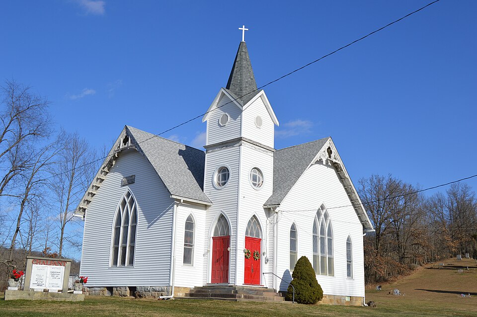
“Chalfant Church is a historic church in Warsaw in Coshocton County, Ohio. It was the first church in the county; the county was formed in 1810.”
Wikipedia article Chalfant Church, CC BY-SA 4.0.
one of 16 National Register listings in Coshocton County · listed in 1982 · category: Building.
National Register reference number.82004416- the number the National Park Service assigned this property when it was listed, and the key its nomination file is catalogued under at the National Archives.
The towhship contains no village and but a single postofiice. This is Wakatomica, situated exactly in the center of the township. Although no village plat was ever made of the land, there is quite a little Chester of houses here, and it, perhaps, deserves the name of a village. A store has been kept at the place for about thirty years. It was started by Charles Houser, who retained it perhaps five or six years, since then it has been owned by a number of men successively. Isaac Piersel purchased it about two years ago and still has possession. The various industrial shops common to a small place like this may be found here. A large building was erected by Darius Wright about 1857, and occupied by him for a blacksmith and wagon shop. The manufacture of wagons was carried on quite extensivelj^ for a while, but ten or twelve years ago Mr. Wright renacved to Warsaw and the shop was closed. Stewart McGinnis is the postmaster,
The towhship contains no village and but a single postoffice. This is Wakatomica, situated exactly in the center of the town.ship. Although no village xjlat was ever made of the land, there is quite a little-chester of houses here, and it, perhaps, deserves the name of a village. A store has been kept at the place for about thirty years. It w'as started by Charles Houser, who retained it perhai)s five or six years, since then it has been owned by a number of men successively. Isaac Piersel purchased it about two years ago and still has possession. The various industrial- shops common to a small place like this may be fovmd here. A large building was erected by Darius Wright about 18.57, and occupied by him for a blacksmith and wagon shop. The manufacture of wagons was carried on quite extensively for a while, but ten or twelve years ago Mr. Wright removed to Warsaw and the shop was closed. Stewart McGinnis is the postmaster.
Regional context, not property-specific
evidence. The
federal wildfire occurrence database
lists 18 fires within 5 miles of Chalfant Church between
2013 and 2020, burning about 84 acres in total. None started naturally. None was recorded as arson.
Distance is straight-line from the map coordinates, so a fire counted
here may appear on a neighbouring settlement's page as well.
Reported cause
Fires
Debris and open burning
9
Missing data/not specified/undetermined
7
Recreation and ceremony
1
Equipment and vehicle use
1
The most recent of
them, most recent first, with the day each was reported and the service
that recorded it.
Regional context, not property-specific
evidence. Museums hold 463 specimens
collected within 10 miles of Chalfant Church between 1846 and
1974: 370 Animalia, 56 Plantae, 36 Fungi, 1 Unrecorded. 12 distinct Species records are shown.
Collected by A. Spreitzer, Albaugh, W. F., Baumgartner and others. Each is a
physical object with a catalogue
number, and each entry opens the museum's record. This is what was
collected and kept, not a survey of what lives here - nothing can be
concluded from a species being absent.
Regional context, not property-specific
evidence. The federal mineral resources record lists
1 working within 5 miles of Chalfant Church: 1 producer.
All of them still produce. What was taken out: Clay. Distance is straight-line from the
map coordinates, so a quarry counted here may appear on a neighbouring
settlement's page as well.
Regional context, not property-specific
evidence. The National Weather Service names
Warsaw, the town this property stands in, in 34 storm reports between 1994 and 2025: 18 thunderstorm wind, 10 flash flood, 4 hail, 2 lightning.
The reports record 1 death. Each account below is quoted exactly as the forecast office
filed it, from the NOAA Storm Events Database, and each date
opens the federal record of that event.
Local media reported a 9 year old boy was struck by lightning and later died. The boy was outside attempting to bring horses into a barn when he was struck.
School buses stranded by flash flood at intersection of County Road 41 and Township Road 78. Another person stranded in car, surrounded by high water, on Township Road 48. Bridge washed out on State Route 60. Doppler radar estimated that on Simmons Run, more than 3 inches of rain fell from 2 to 3 pm EDT with a total of 6.2 inches, from 1 pm to 4 pm EDT. On Flint Run, more than 3.5 inches of rain fell from 2 to 3 pm EDT, with a total of 6.9 inches from 1 pm to 4 pm EDT. Flooding of State Route 60, Township Road 55, and County Road 41 continued through 9 PM EDT.
At 9 AM EDT, State Rte 715 was flooded and closed behind Mohawk Dam Also, along Killbuck Creek these roads flooded: SR 60 from Layland to Blissfield, southward to Rte 36. County Rd 24 near Metham flooded. At 11 PM EDT on the 17th, several roads remained flooded. At 1002 PM EDT on the 17th, Rte 83 flooded 8 miles north of Coshocton.
No historic map-sheet match is published
for this property yet. That does not mean no map exists. This record needs
a coordinate-quality review before it can be joined to a sheet boundary.
Browse the county's mapped places while that work is
pending.
From the nomination file
1,695 words on record
When this property was proposed for the
National Register, someone wrote the case for it: what the building is,
and why it matters. That document is a federal record in the public domain.
It is quoted below word for word, never summarised. The text was read off the scanned case file by machine, so the
occasional stray character is the recogniser's and the 1970s
typewriter's.
Description of the property
The Chalfant Church is a wood frame structure which rests on a foundation of rock- the southwest corner of the building and framed by two projecting gables is a tall spire. This wooden structure is articulated by elaborate wood trim and louvered openings and is sets of doors on two sides which feature their original brass fittings and are reached by sets of stone steps. To the rear is another entrance and an outside stairway leading to the half basement. ornamented all window openings but were recently removed and stored to prevent theft until elliptical railing and an inner railing. The church enjoys a picturesque rural setting. It is located in a hilly but culti- which rises up a fairly steep hill. It contains monuments from the late nineteenth and early twentieth centuries.
Across the road is an older and larger cemetery which has a number of very early sandstone monuments, some of which date from the 1820's. Behind the church is a recently erected picnic shelter, the only other structure on the unexposed property. excellent 7. Description - moveddate Condition .deteriorated faced sandstone. It is cross shaped in plan and is capped by intersecting gable roofs covered with slate. Three of the four gable ends each feature a large gothic window, accented by corner boards and bargeboard trim on each of the gable ends. Rising up from crowned by a steeply pitched pyramidal roof topped with a spire and weathervane.
The vertical windows, steeply pitched gable roof and the tall slender spire give this building The interior of the church consists of a single large meeting room featuring a pulpit at the east end and a small entryhall beneath the tower. Elaborate stained glass windows vated area with no other buildings in the vicinity.
(in one paragraph) and occupies the site of the first church building erected in the county. For many years during the nineteenth and early twentieth centuries this was a remarkably active rural end of the nineteenth century the congregation built a remarkable building, considering its isolated rural location, which is an excellent example of Victorian Gothic architecture that is well preserved; perhaps the finest rural church in Coshocton County. The congregation was founded in 1808 by Rev. William Ellington, who became its first church was closed due to a dwindling congregation and a couple of years later was deeded church has been maintained by Grace Church as a memorial to a past minister at their 1893 1500-1599 economics 1700-1799 1400-1499 communications commerce humanitarian church.
industry engineering archeology-historic Builder/Architect military theater music literature Period conservation law 8. Significance 1900- Specific dates by the Methodist church conference to Grace United Methodist Church in Coshocton.The education The Chalfant Church was home to the first religious congregation in Coshocton County - other(specify) _ archeology-prehistoric X architecture X exploration/settlement - philosophy pastor and a place of worship was begun in 1811. It was located on land owned by Mordecai Chalfant which was originally intended by Rev. Ellington to become a community.
Chalfant meeting house was replaced by a wood frame building in 1849 which was repaired and remodeled 1600-1699 art was one of the area'searliest settlers and a prosperous farmer.In its earliest days nearly all the original members were from nearby Muskingum County.The original 1og - - communityplanning N.N. Hill, History of Coshocton County, Newark, O.: A.A. Graham & Co., 1881, p. 617. The Times Reporter, New Philadelphia, Ohio, June 7, 1980, p. B-4.
Quoted from the National Register nomination
for reference 82004416, 12 pages, held by the National Archives in Record
Group 79. See the
catalogue record.
Listed places nearby
1 within 8 miles
Other National Register properties close
enough to walk or drive between, ordered by distance from this one. Both
positions come from the same geocoding pass that matched these properties
to their map sheets.
Listing record. National Park Service National Register of Historic Places, listed-properties dataset, current to 2026-05-22.
Map join. Address geocoded through the United States Census geocoder, then tested against the published boundary of every sheet in the USGS Historical Topographic Map Collection.
How this page is made. Listing fields come from federal records; map-sheet coverage is a labelled coordinate-to-boundary calculation, not a source-field claim.
Wildfire. Short, Karen C. 2022. Spatial wildfire occurrence data for the United States, 1992-2020 [FPA_FOD_20221014]. 6th Edition. Fort Collins, CO: Forest Service Research Data Archive. https://doi.org/10.2737/RDS-2013-0009.6 Collected with United States Government funding and usable without additional permissions or fees.
Specimens. Global Biodiversity Information Facility (GBIF), https://www.gbif.org/. Only records licensed CC0 or CC BY are used. Records licensed CC BY-NC are excluded because this site carries advertising. Images are checked individually and any whose licence is non-commercial, no-derivatives or unreadable is refused.
Mines and quarries. USGS Mineral Resources Data System (MRDS) https://mrdata.usgs.gov/mrds/ A work of the United States government, no copyright under 17 U.S.C. 105.
Storms. NOAA National Centers for Environmental Information, Storm Events Database https://www.ncei.noaa.gov/stormevents/ A work of the United States government, no copyright under 17 U.S.C. 105. Narratives are quoted verbatim from the National Weather Service report and are not edited or summarised.
 Block
Block